The instrument's own words
page 1
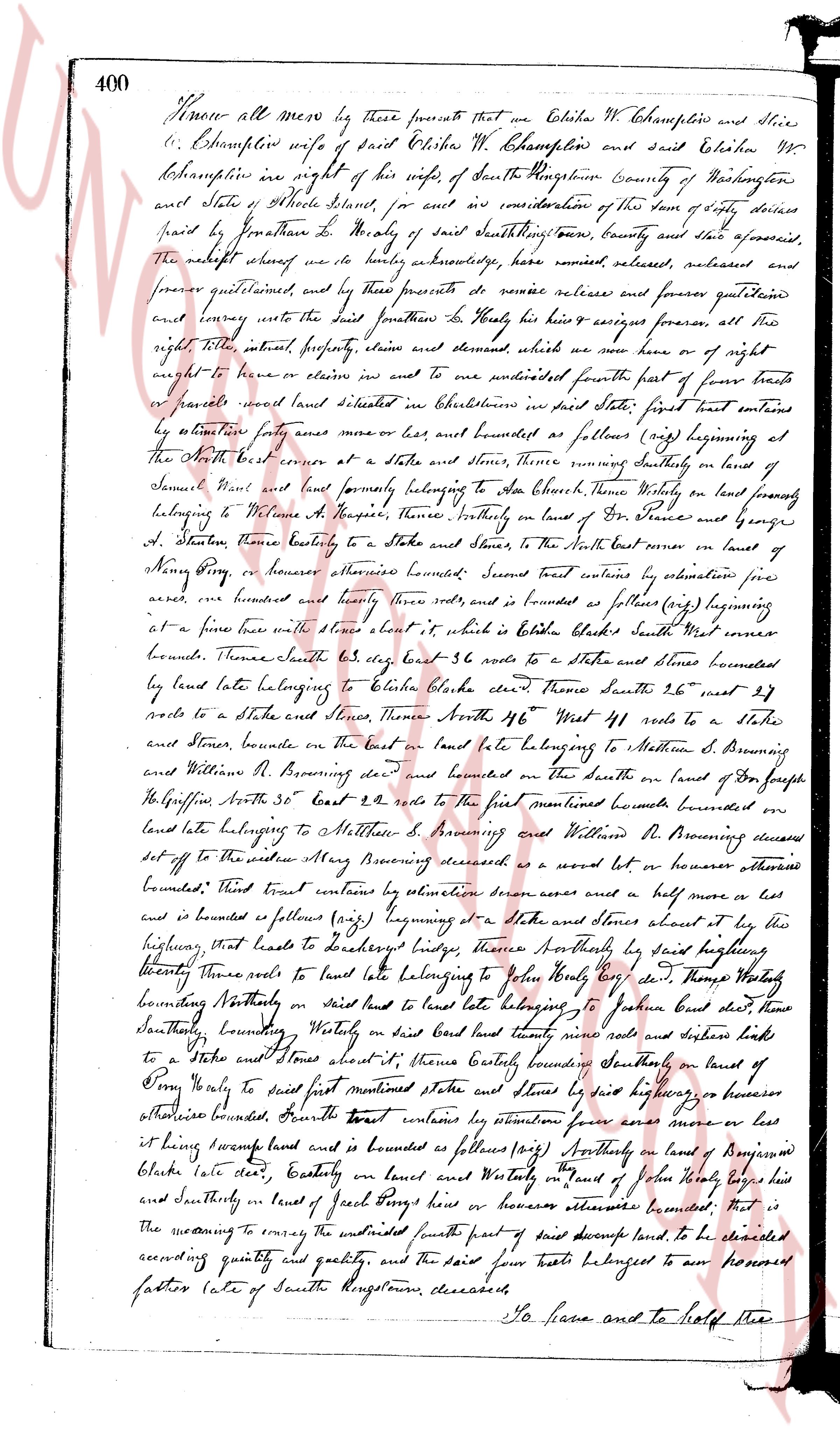
400 Know all men by these presents that we Elizabeth W. Champelin and Silas
C. Champelin her husband wife of said Elizabeth W. Champelin and said Elizabeth W
Champelin in right of his wife of the town of North Kingstown County of Washington
and state of Rhode Island aforesaid for and in consideration of the sum of fifty dollars
paid by Jonathan D. Healy of said North Kingstown County and state aforesaid
the receipt whereof we do hereby acknowledge have remised released and forever
forever quitclaimed and by these presents do remise release and forever quitclaim
and convey unto the said Jonathan D. Healy his heirs & assigns forever all the
right title interest property claims and demand whatever we now have or of right
ought to have or claim or entitle us in and unto one hundred fifty four parts of four
tenths or parcels wood land situated in Charlestown in said state first part contains
by estimation forty acres more or less and is bounded as follows viz beginning at
the North west corner at a stake and stones thence southerly on land of
Samuel Want and land formerly belonging to Lt Col Enoch Thorne vicinity on land
belonging to Nathan A. Hooper thence southerly on land of Dr France and george
A. Stanton thence easterly to a stake and stones thence to the North east corner on land of
Nancy King or whoever otherwise bounded bounded Second part contains by estimation one
acre and hundred and twenty rods and is bounded as follows viz beginning at
a fore tree with three blaze thereon it which is bolted to Elizabeth Blake's South west corner
bounds Thence southeast 43 deg east 36 rods to a stake and stones bounded
by land late belonging to Elizabeth Blake deceased Thence South 26 deg west 27
rods to a stake and stones highway Thence North 46 deg West 41 rods to a
stake and stones bounded on the east on land late belonging to Matthew S. Browning
and William R. Browning deceased and bounded on the north on land of Joseph
H. Griffin South 30 deg East 22 rods to the first mentioned bounds bounded easterly
on land late belonging to Matthew S. Browning and William R. Browning deceased
set off to the widow Mary Browning deceased as a sword lot or whoever otherwise
bounded Third part contains by estimation seven acres and a half more or less
bounded and is bounded as follows viz beginning at a stake and stones about by his
highing that leads to South Kingstown highway Thence Southeasterly by said highwaying
twenty three rods to land late belonging to John Healy son of Thos Healy
bounding Northly on said land late belonging to John Healy said stake thence
southerly Bounding Westerly on said land late belonging nine rods and daughter rods
to a stake and stones about said thence easterly bounding Southerly on land of
John Healy to said first mentioned stake and stones by said highway or whoever
otherwise bounded Fourth part contains by estimation four acres more or less
it being swamp land and is bounded as follows viz Northly on land of Joseph
Blake late state easterly on land and Westerly on land of John Healy late land
and southerly on land of Jacob King house or whoever otherwise bounded That is
to meaning to convey the untitled south part of said swamp land to be cleared
according quantity and quality and the said four parts belonged to our honored
father late of South Kingstown deceased
So to have and to hold free
page 2
401
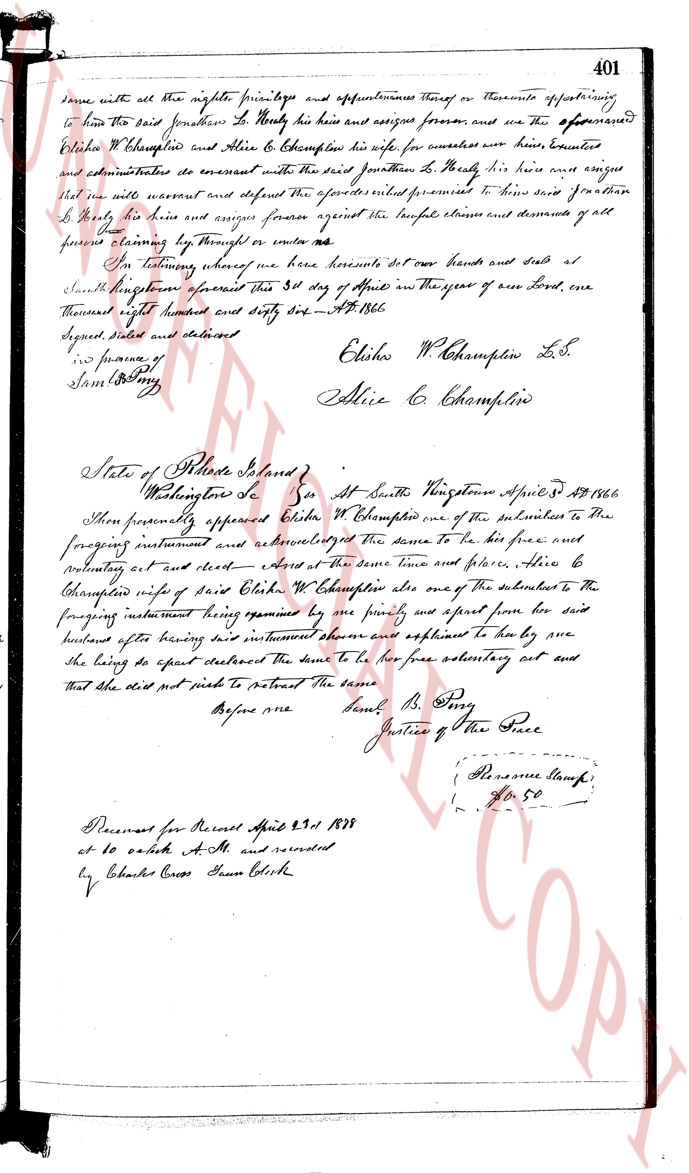
same with all the rights, privileges and appurtenances thereof or thereunto appertaining
to him the said Jonathan H. Nearly his heirs and assigns forever, and we the aforementioned
Elisha W. Champlin and Alice E. Champlin his wife for ourselves our heirs, executors
and administrators do covenant with the said Jonathan H. Nearly his heirs and assigns
that we will warrant and defend the aforesaid premises to him said Jonathan
H. Nearly his heirs and assigns forever against the lawful claims and demands of all
persons claiming by way through or under us.
In testimony whereof we hereunto set our hands and seal at
North Kingstown aforesaid this 31st day of April in the year of our Lord, one
thousand eight hundred and eighty six. A.D. 1886.
Signed, sealed and delivered
in presence of
Sam B. Ping
Elisha W. Champlin L.S.
Alice E. Champlin
State of Rhode Island
Washington Co Ss At North Kingstown April 31st 1886
Then personally appeared Elisha W. Champlin one of the subscribers to the
foregoing instrument and acknowledged the same to be his free and
voluntary act and deed - street - At the same time and place, Alice E
Champlin wife of said Elisha W. Champlin also one of the subscribers to the
foregoing instrument being examined by me privately and apart from her said
husband after having said instrument shown and explained to her by me
she being so exact declared the same to be her free voluntary act and
that she did not wish to retract the same.
Before me
Sam B. Ping
Justice of the Peace
(Reserve Stamp)
(Fee 50)
Received for Record April 23rd 1888
at 10 o'clock A.M. and recorded
by Charles Cross Town Clerk
The page as recorded