The instrument's own words
page 1 · read by Gemma vision
599
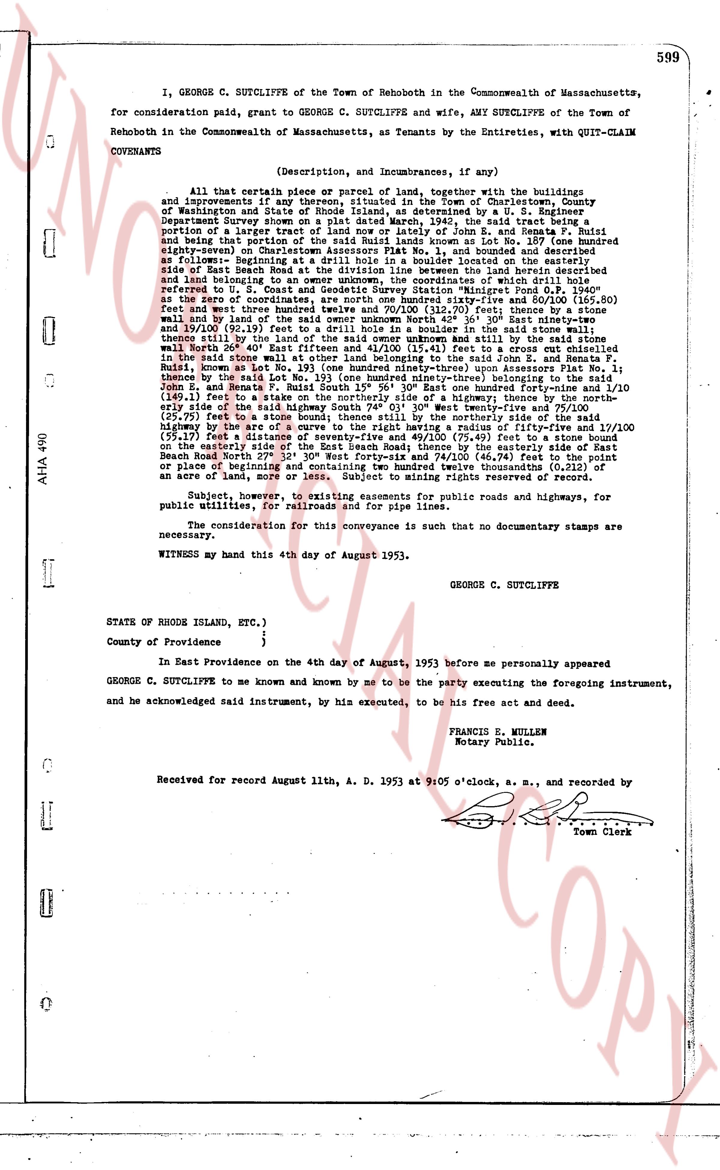
I, GEORGE C. SUTCLIFFE of the Town of Rehoboth in the Commonwealth of Massachusetts, for consideration paid, grant to GEORGE C. SUTCLIFFE and wife, AMY SUTCLIFFE of the Town of Rehoboth in the Commonwealth of Massachusetts, as Tenants by the Entireties, with QUIT-CLAIM COVENANTS
(Description, and Incumbrances, if any)
All that certain piece or parcel of land, together with the buildings and improvements if any thereon, situated in the Town of Charlestown, County of Washington and State of Rhode Island, as determined by a U. S. Engineer Department Survey shown on a map dated September 22, 1942, now and then being a portion of a larger tract of land now or lately of John E. E. and Renata P. Ruiz and being part of the property conveyed to me as trustee as shown on Lot No. 1, described as follows:- Beginning on Charlestown Assessors Plat No. 1, bound and described as follows:- Beginning on the northeasterly side of the road now known as the road located on the side of East Beach Road at the division line between the land herein described and land adjoining to the northeast, the point of beginning of which is the stone bound referred to U. S. Coast and Geodetic Survey Station "Minigret Pond O.F. 1940" square coordinates, are north One hundred fifty-five and eighty-five 100/100 (155.85) feet and west three hundred twenty-one feet seventy-two 100/100 (321.72) feet thence bearing North east forty-two 36' 50" East sixty ninety-two and thirty-one 100/100 (692.31) feet to a stone bound on the division line between the land herein described and the land of the said owner unknown North forty-two 36' 50" East sixty ninety-two and thirty-one 100/100 (692.31) feet to a stone bound on the division line between the land herein described and the land of the said owner unknown North forty-two 36' 50" East sixty ninety-two and thirty-one 100/100 (692.31) feet to a stone bound on the division line between the land herein described and the land of the said owner unknown North forty-two 36' 50" East sixty ninety-two and thirty-one 100/100 (692.31) feet to a stone bound on the division line between the land herein described and the land of the said owner unknown North forty-two 36' 50" East sixty ninety-two and thirty-one 100/100 (692.31) feet to a stone bound on the division line between the land herein described and the land of the said owner unknown North forty-two 36' 50" East sixty ninety-two and thirty-one 100/100 (692.31) feet to a stone bound on the division line between the land herein described and the land of the said owner unknown North forty-two 36' 50" East sixty ninety-two and thirty-one 100/100 (692.31) feet to a stone bound on the division line between the land herein described and the land of the said owner unknown North forty-two 36' 50" East sixty ninety-two and thirty-one 100/100 (692.31) feet to a stone bound on the division line between the land herein described and the land of the said owner unknown North forty-two 36' 50" East sixty ninety-two and thirty-one 100/100 (692.31) feet to a stone bound on the division line between the land herein described and the land of the said owner unknown North forty-two 36' 50" East sixty ninety-two and thirty-one 100/100 (692.31) feet to a stone bound on the division line between the land herein described and the land of the said owner unknown North forty-two 36' 50" East sixty ninety-two and thirty-one 100/100 (692.31) feet to a stone bound on the division line between the land herein described and the land of the said owner unknown North forty-two 36' 50" East sixty ninety-two and thirty-one 100/100 (692.31) feet to a stone bound on the division line between the land herein described and the land of the said owner unknown North forty-two 36' 50" East sixty ninety-two and thirty-one 100/100 (692.31) feet to a stone bound on the division line between the land herein described and the land of the said owner unknown North forty-two 36' 50" East sixty ninety-two and thirty-one 100/100 (692.31) feet to a stone bound on the division line between the land herein described and the land of the said owner unknown North forty-two 36' 50" East sixty ninety-two and thirty-one 100/100 (692.31) feet to a stone bound on the division line between the land herein described and the land of the said owner unknown North forty-two 36' 50" East sixty ninety-two and thirty-one 100/100 (692.31) feet to a stone bound on the division line between the land herein described and the land of the said owner unknown North forty-two 36' 50" East sixty ninety-two and thirty-one 100/100 (692.31) feet to a stone bound on the division line between the land herein described and the land of the said owner unknown North forty-two 36' 50" East sixty ninety-two and thirty-one 100/100 (692.31) feet to a stone bound on the division line between the land herein described and the land of the said owner unknown North forty-two 36' 50" East sixty ninety-two and thirty-one 100/100 (692.31) feet to a stone bound on the division line between the land herein described and the land of the said owner unknown North forty-two 36' 50" East sixty ninety-two and thirty-one 100/100 (692.31) feet to a stone bound on the division line between the land herein described and the land of the said owner unknown North forty-two 36' 50" East sixty ninety-two and thirty-one 100/100 (692.31) feet to a stone bound on the division line between the land herein described and the land of the said owner unknown North forty-two 36' 50" East sixty ninety-two and thirty-one 100/100 (692.31) feet to a stone bound on the division line between the land herein described and the land of the said owner unknown North forty-two 36' 50" East sixty ninety-two and thirty-one 100/100 (692.31) feet to a stone bound on the division line between the land herein described and the land of the said owner unknown North forty-two 36' 50" East sixty ninety-two and thirty-one 100/100 (692.31) feet to a stone bound on the division line between the land herein described and the land of the said owner unknown North forty-two 36' 50" East sixty ninety-two and thirty-one 100/100 (692.31) feet to a stone bound on the division line between the land herein described and the land of the said owner unknown North forty-two 36' 50" East sixty ninety-two and thirty-one 100/100 (692.31) feet to a stone bound on the division line between the land herein described and the land of the said owner unknown North forty-two 36' 50" East sixty ninety-two and thirty-one 100/100 (692.31) feet to a stone bound on the division line between the land herein described and the land of the said owner unknown North forty-two 36' 50" East sixty ninety-two and thirty-one 100/100 (692.31) feet to a stone bound on the division line between the land herein described and the land of the said owner unknown North forty-two 36' 50" East sixty ninety-two and thirty-one 100/100 (692.31) feet to a stone bound on the division line between the land herein described and the land of the said owner unknown North forty-two 36' 50" East sixty ninety-two and thirty-one 100/100 (692.31) feet to a stone bound on the division line between the land herein described and the land of the said owner unknown North forty-two 36' 50" East sixty ninety-two and thirty-one 100/100 (692.31) feet to a stone bound on the division line between the land herein described and the land of the said owner unknown North forty-two 36' 50" East sixty ninety-two and thirty-one 100/100 (692.31) feet to a stone bound on the division line between the land herein described and the land of the said owner unknown North forty-two 36' 50" East sixty ninety-two and thirty-one 100/100 (692.31) feet to a stone bound on the division line between the land herein described and the land of the said owner unknown North forty-two 36' 50" East sixty ninety-two and thirty-one 100/100 (692.31) feet to a stone bound on the division line between the land herein described and the land of the said owner unknown North forty-two 36' 50" East sixty ninety-two and thirty-one 100/100 (692.31) feet to a stone bound on the division line between the land herein described and the land of the said owner unknown North forty-two 36' 50" East sixty ninety-two and thirty-one 100/100 (692.31) feet to a stone bound on the division line between the land herein described and the land of the said owner unknown North forty-two 36' 50" East sixty ninety-two and thirty-one 100/100 (692.31) feet to a stone bound on the division line between the land herein described and the land of the said owner unknown North forty-two 36' 50" East sixty ninety-two and thirty-one 100/100 (692.31) feet to a stone bound on the division line between the land herein described and the land of the said owner unknown North forty-two 36' 50" East sixty ninety-two and thirty-one 100/100 (692.31) feet to a stone bound on the division line between the land herein described and the land of the said owner unknown North forty-two 36' 50" East sixty ninety-two and thirty-one 100/100 (692.31) feet to a stone bound on the division line between the land herein described and the land of the said owner unknown North forty-two 36' 50" East sixty ninety-two and thirty-one 100/100 (692.31) feet to a stone bound on the division line between the land herein described and the land of the said owner unknown North forty-two 36' 50" East sixty ninety-two and thirty-one 100/100 (692.31) feet to a stone bound on the division line between the land herein described and the land of the said owner unknown North forty-two 36' 50" East sixty ninety-two and thirty-one 100/100 (692.31) feet to a stone bound on the division line between the land herein described and the land of the said owner unknown North forty-two 36' 50" East sixty ninety-two and thirty-one 100/100 (692.31) feet to a stone bound on the division line between the land herein described and the land of the said owner unknown North forty-two 36' 50" East sixty ninety-two and thirty-one 100/100 (692.31) feet to a stone bound on the division
The page as recorded