The instrument's own words
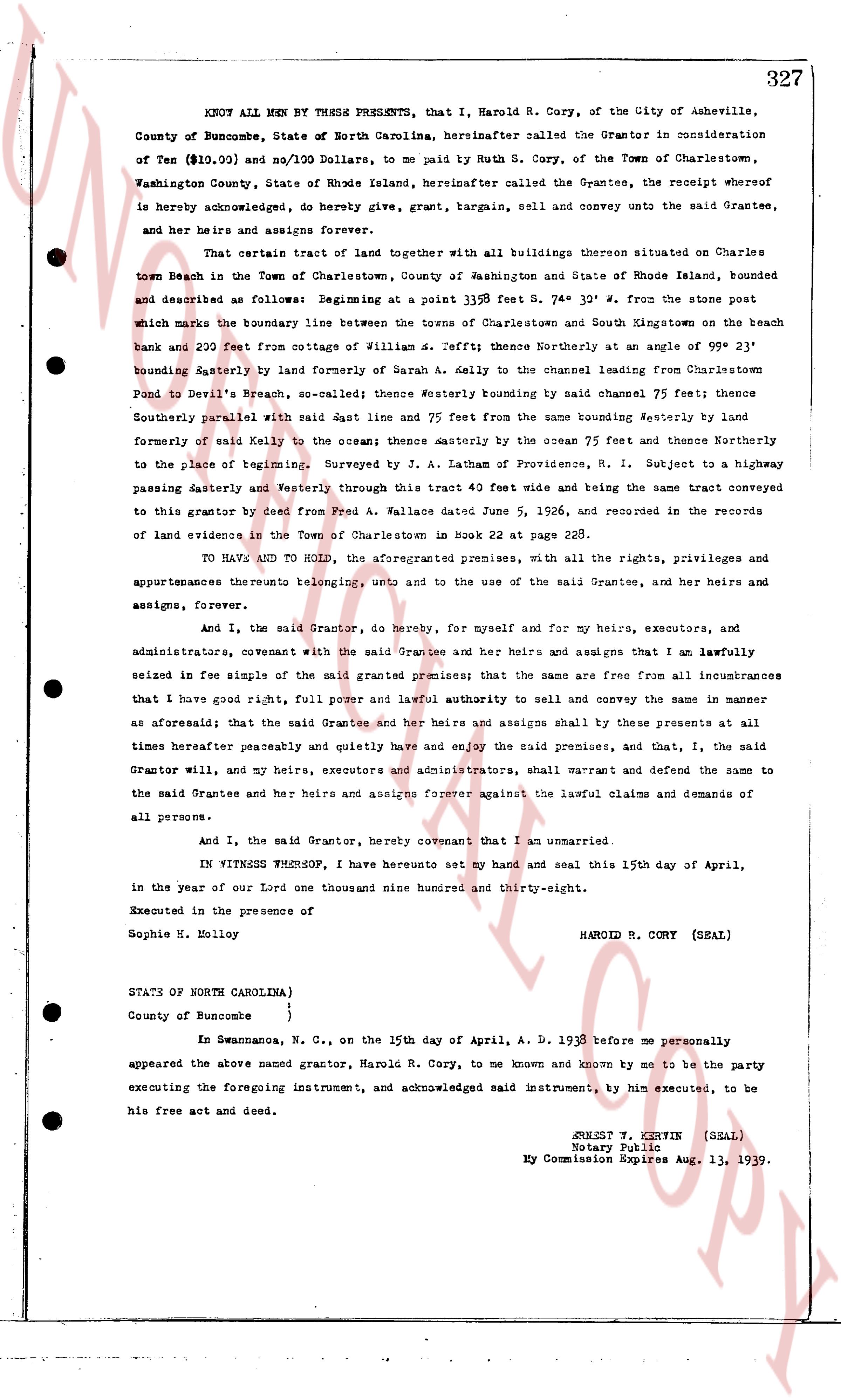
page 1
KNOW ALL MEN BY THESE PRESENTS, that I, Harold R. Cory, of the City of Asheville,
County of Buncombe, State of North Carolina, hereinafter called the Grantor in consideration
of Ten ($\$10.00$) and no $100$ Dollars, to me paid by Ruth S. Cory, of the Town of Charlestown,
Washington County, State of Rhode Island, hereinafter called the Grantee, the receipt whereof
is hereby acknowledged, do hereby give, grant, bargain, sell and convey unto the said Grantee,
and her heirs and assigns forever,
That certain tract of land together with all buildings thereon situated on Charles
Town Beach in the Town of Charlestown, County of Washington and State of Rhode Island, bounded
and described as follows: Beginning at a point $339$ feet S. $74^\circ$ $32'$ W. from the stone post
which marks the boundary line between the towns of Charlestown and South Kingstown on the beach
bank and $200$ feet from cottage of William S. Jeffit; thence Northeasterly at an angle of $99^\circ$ $23'$
bounding Easterly by line formed of Barns A. Kelly to the channel leaving Charlestown from
Pond to Devil's Breach, so-called; thence Westerly bounding by said channel $75$ feet; thence
Southerly parallel with said East line and $75$ feet from the same bounding Westerly by land
formed of said Kelly to the ocean thence Southerly by the ocean $75$ feet and thence Northerly
to the place of beginning. Surveyed by J. A. Lathan of Providence, R. I. Subject to a highway
passing Easterly and Westerly through this tract $40$ feet wide and being the same tract conveyed
to this grantor by deed from Fred A. Wallace dated June $5$, $1926$, and recorded in the records
of land evidences in the Town of Charlestown in book $22$ page $22$ AB.
TO HAVE AND TO HOLD, the aforementioned premises, with all the rights, privileges and
appurtenances thereto belonging, only and to the use of the said Grantee, and her heirs and
assigns, forever.
And I, the said Grantor, do hereby, for myself and for my heirs, executors, and
administrators, covenant with the said Grantee and her heirs and assigns that I am lawfully
seized in fee simple of the said granted premises; that the same are free from all incumbrances
that I have good right, full power and lawful authority to sell and convey the same in manner
as aforesaid; that the said Grantee and her heirs and assigns shall by these presents at all
times hereafter peaceably and quietly have and enjoy the said premises, and that, I, the said
Grantor will, and my heirs, executors and administrators, shall warrant and defend the same to
the said Grantee and her heirs and assigns forever against the lawful claims and demands of
all persons.
And I, the said Grantor, hereby covenant that I am an unmarried.
IN WITNESS WHEREOF, I have hereunto set my hand and seal this $15$th day of April,
in the year of our Lord one thousand one hundred and thirty-eight.
Executed in the presence of the
Sophie H. Holly
HAROLD R. CORY (SEAL)
STATE OF NORTH CAROLINA)
County of Buncombe )
In Swannanoa, N. C., on the $15$th day of April, A. D. $1938$ before me personally
appeared the above named grantor, Harold R. Cory, to me known and known by me to be the party
executing the foregoing instrument, and acknowledged said instrument, by him executed, to be
his free act and deed.
SHERBERT F. KERWIN (SEAL)
Notary Public
My Commission Expires Aug. $13$, $1939$.
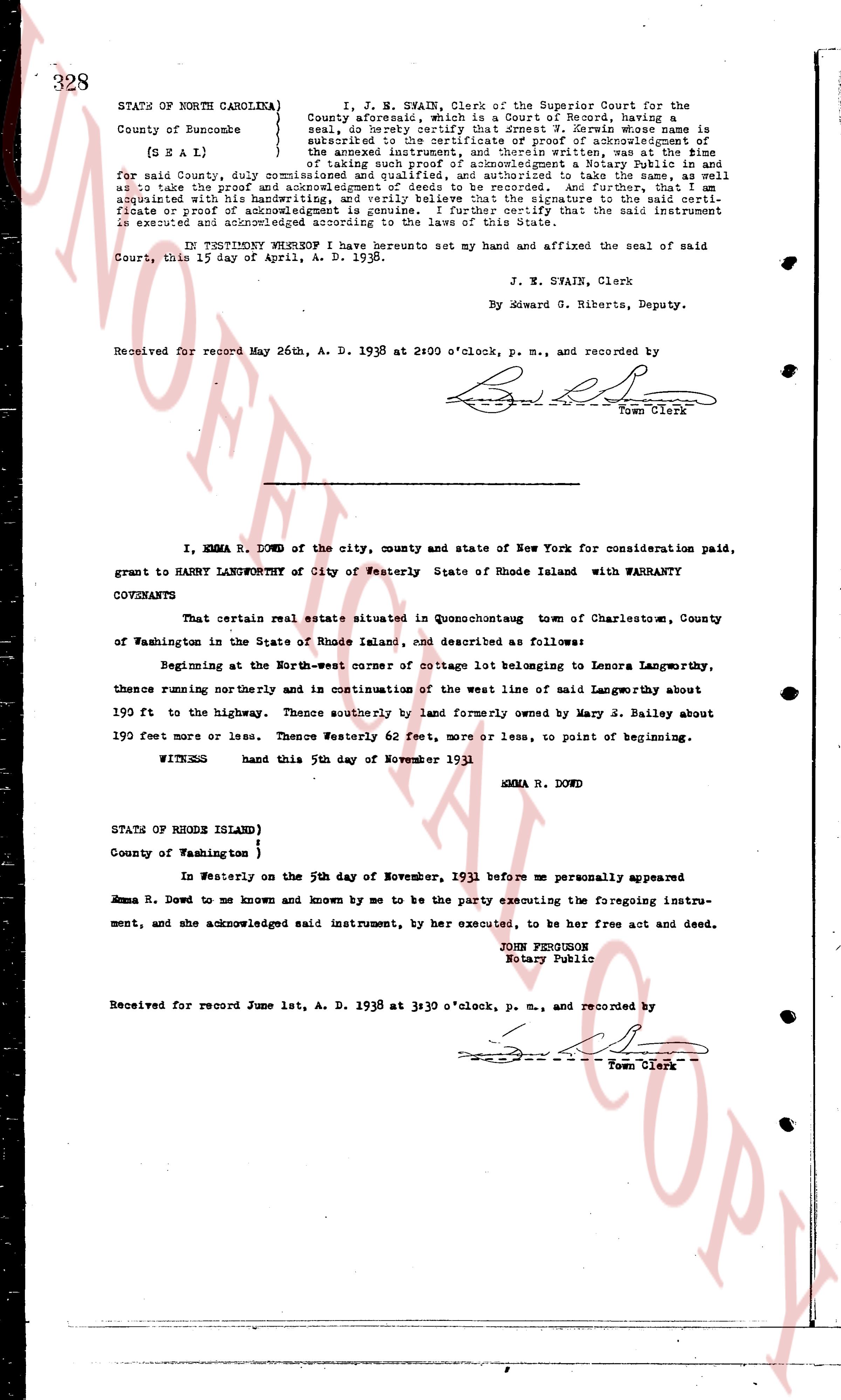
page 2
328 STATE OF NORTH CAROLINA } I, J. N. SVAIN, Clerk of the Superior Court for the
County of Buncombe which is a Court of Records, having
seal, do hereby certify that Ernest Z. Forwin whose name is
subscribed to the certificate of proof of acknowledgment of
[ SEAL ] the instrument hereunto annexed, has declared his
for said County, duly commissioned and qualified, to take
of taking such proof of acknowledgment a Notary Public in and
as to take the proof and acknowledgments of deeds to be recorded. And further, that an
examination of the handwriting in the signature to the instrument and the certificate
cricate or proof of acknowledgment is genuine. I further certify that the said instrument
executed and acknowledged according to the laws of this State.
Court, this 17 day of April, A. D. 1938.
IN TESTIMONY WHEREOF I have hereunto set my hand and affixed the seal of said
The page as recorded