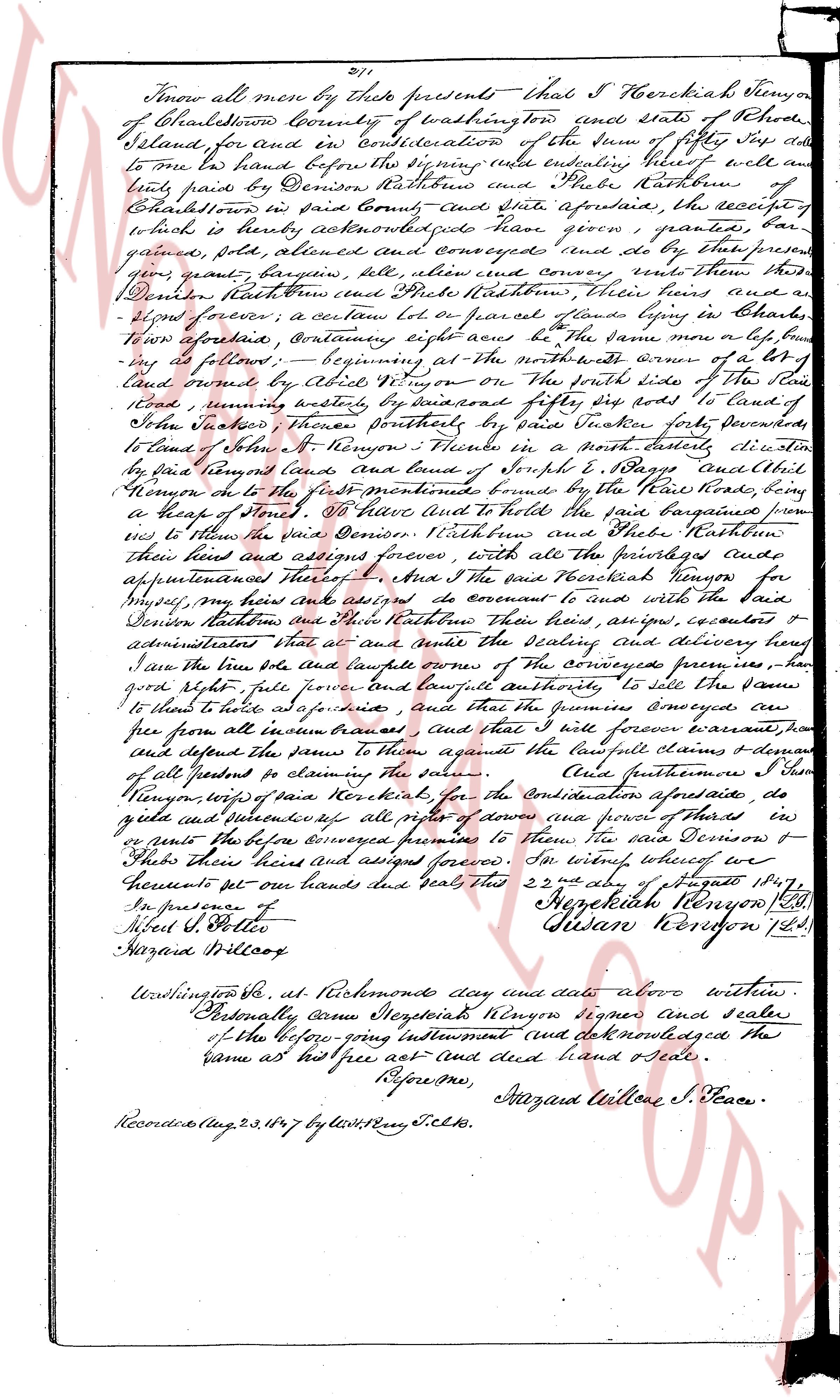
The instrument's own words
page 1
211
Know all men by these presents that I Hezekiah Kenyon
of Charlestown County of washington tow and state of Rhode
Island, for and by consideration of the sum of fifty six dollars
to me in hand before the signing these writes ending witness where of all
and sundry parts by Denison Rathbone and Silas Rathbone of
Charlestown in said County and State aforesaid, the receipt of
which is hereby acknowledged have given granted
gave granted sold alienated and conveyed (and do by these presents
give grant bargain sell alien and convey) unto them the
said Denison Rathbone and Silas Rathbone their heirs and
assigns forever, a certain lot or parcel of land lying by Charles
Town aforesaid containing eight acres be the same more or less
as follows: beginning at the North westerly corner of a lot
of land owned by Abel Kenyon on the North side of the line
road running easterly by distance of one hundred fifty six rods to land of
John Jacobs whereas northeast by distance one hundred ninety
rods to land of Jonathan Kenyon whereas in a north easterly direction
by distance two hundred rods and land of Joseph S. Lapsley and Abel
Kenyon on the said front boundaries bound by the line road running
in a heap of stones 30 rods and to hold to have and appertain from
us to the said parties Consider Rathbone and Silas Rathbone their
heirs and assigned forever with all the privileges and
appurtenances thereunto belonging. Also I the said Hezekiah Kenyon for
myself my heirs and assigns do covenant and agree with the said
Denison Rathbone and Silas Rathbone their heirs assigns executors &
administrators that we and our heirs shall the selling and delivery hereby
save the same title sole and lawful owner of the conveyed premises
have good right full power full power and lawful authority to sell the same
to the said to have and possess and that the premises conveyed are
free from all liens encumbrances and that will forever warrant run
sure defend the same to them against the lawfull claiming & domain
of all persons so claiming the same. Also furthermore I do
hereby appoint Hezekiah Kenyon for the consideration aforesaid do
give and deliver up all rights of power of tenure and power of Thirds
in or parts to the before conveyed premises to the said Denison &
Silas their heirs and assigned forever. In witness whereof we
hereunto set our hands and seals this 22nd day of august 1847
In presence of
Samuel S. Potter
Hazard Wilcox
Hezekiah Kenyon (L.S.)
Denison Rathbone (L.S.)
Charlestown R.I. at Richmonds day and date above written
Personally came Hezekiah Kenyon signer and sealer
of the before going instrument and acknowledged the
same as his free act and deed hand & seal
Before me,
Hazard Willone S. Justice
Recorded Aug 23, 1847 by Lew S. Fry C.l.s.
The page as recorded