The Deed Walker · From Ninigret · Charlestown, Rhode Island land evidence, 1738 to today
Trail: 96@29/273

9/20/1944 · DEED · book 29 page 273 doc 96@29/273

From JULIA MAYERS, JULIA MAYER, TOURGEE GEORGE W DECEASED life
To LAMPHERE HAROLD E
Premises approximately fifty (50) acres, more or less; fifty acres, more or less · Two tracts including a dwelling house (Charlestown, Holloway land, Zachary's Bridge, Lewis Kenyon, George W. Tourgee, Green's land, Jonathan Chappell)
Index description SEE DOC

Back — where this land came from

heir George W. Tourgee
“an heir-at-law of George W. Tourgee”
no book and page cited; the source is named, not recorded here
read by: gemma

Forward — where this land went

The grantee's later conveyances, by name — the man, not necessarily this land; the one that cites this deed as its source is the land

▶ 1944 · MORTGAGE DISCHARGE · LAMPHERE HAROLD E; LAMPHERE ALICE W → TOURGEE RUEBEN T · book 29 p 134
▶ 1944 · MORTGAGE · LAMPHERE HAROLD E → LANPHERE ANNA R; LANPHERE JOSEPH E · book 29 p 284
▶ 1957 · DEED · LAMPHEAR HAROLD E; LAMPHERE HAROLD E → JORDAN HARRIET H · book 36 p 5
▶ 1957 · DEED · LAMPHEAR HAROLD E; LAMPHERE HAROLD E → JORDAN HARRIET H · book 36 p 66
▶ 1957 · DEED · LAMPHEAR HAROLD E; LAMPHERE HAROLD E → JORDAN HARRIET H · book 36 p 84
▶ 1958 · DEED · LAMPHEAR HAROLD E; LAMPHERE HAROLD E → BOISCLAIR JOHN C; BOISCLAIR SHIRLEY A · book 36 p 410
▶ 1959 · DEED · LAMPHEAR HAROLD E; LAMPHERE HAROLD E → ELY CLARA A; ELY HARRY J · book 37 p 17
▶ 1959 · DEED · LAMPHEAR HAROLD E; LAMPHERE HAROLD E → BROWN PHYLLIS T · book 37 p 17
▶ 1959 · DEED · LAMPHEAR HAROLD E; LAMPHERE HAROLD E → LALLO EDWARD O; LALLO RUBY F · book 36 p 546
▶ 1959 · DEED · LAMPHEAR HAROLD E; LAMPHERE HAROLD E → ELY CLARA A; ELY HARRY J · book 36 p 604
▶ 1961 · DEED · JORDAN ARTHUR K; JORDAN HARRIET H; LAMPHERE HAROLD E → CARR JANE I; CARR JESSE R · book 37 p 538
▶ 1966 · DEED · JORDAN ARTHUR K; JORDAN HARRIET H; LAMPHERE HAROLD E; LANPHEAR HAROLD → KENYON ANDREW F · book 41 p 32
▶ 1966 · DEED · JORDAN ARTHUR K; JORDAN HARRIET; JORDAN HARRIETT H; LAMPHEAR HAROLD E; → JORDAN ROBERT; JORDAN CLARA I · book 41 p 36
▶ 1969 · DEED · JORDAN ARTHUR K; JORDAN HARRIET H; LAMPHERE HAROLD E → CARR JANE I; CARR JESSE R · book 43 p 139
▶ 1969 · AGREEMENT · CARR JANE I; CARR JESSE R; JORDAN ARTHUR K; JORDAN HARRIET H; LAMPHERE → LAMPHERE HAROLD E; JORDAN HARRIET H; JORDAN ARTHUR K; CARR JESSE R; CA · book 43 p 140
▶ 1969 · DEED · JORDAN ARTHUR K; JORDAN HARRIET H; LAMPHERE HAROLD E → JORDAN ROBERT; JORDAN CLARA I · book 43 p 145

The instrument's own words

page 1 · read by Gemma vision
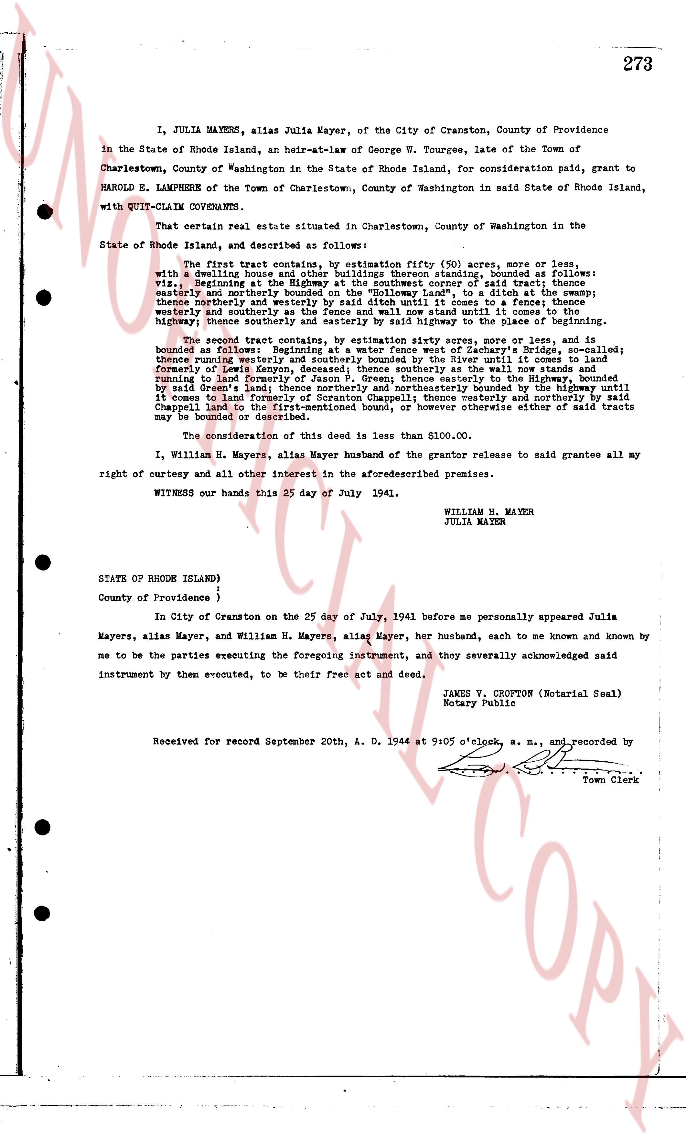
273 I, JULIA MAYERS, alias Julia Mayer, of the City of Cranston, County of Providence in the State of Rhode Island, an heir-at-law of George W. Tourgee, late of the Town of Charlestown, County of Washington in the State of Rhode Island, for consideration paid, grant to HAROLD E. LAMPHERE of the Town of Charlestown, County of Washington in said State of Rhode Island, with QUIT-CLAIM COVENANTS. That certain real estate situated in Charlestown, County of Washington in the State of Rhode Island, and described as follows: The first tract contains approximately fifty (50) acres, more or less, with a dwelling house and other buildings thereon standing, bounded as follows: viz, Beginning at the Highway at the southwest corner of said tract; thence easterly and northerly bounded on the "Holloway land", to a ditch at the swamp; thence southerly and westerly bounded on the "Holloway land", to the Highway; thence westerly and southerly as the fence and wall now stand until it comes to the Highway; thence northerly and easterly bounded by the Highway to the place of beginning. The second tract contains, by estimation fifty acres, more or less, and is bounded as follows: Beginning at water fence south of Zachary's Bridge, so called; thence running westerly and northerly bounded by a river until it comes to land formerly of Lewis Kenyon, deceased; thence southerly as the wall now stands and running to land formerly of George W. Tourgee, deceased; thence easterly bounded by said Green's land; thence northerly and northeasterly bounded by the highway until it comes to land formerly of Jonathan Chappell; thence easterly and northerly by said Chappell land to the first-mentioned bound, or however otherwise either of said tracts may be bounded or described. The consideration of this deed is less than $100.00. I, William H. Mayers, alias Mayer husband of the grantor release to said grantee all my right of curtesy and all other interest in the aforesaid described premises. WITNESS our hands this 25 day of July 1941. WILLIAM H. MAYER JULIA MAYER STATE OF RHODE ISLAND) ) County of Providence } In City of Cranston on the 25 day of July, 1941 before me personally appeared Julia Mayers, alias Mayer, and William H. Mayers, alias Mayer, her husband, each to me known and known by me to be the parties executing the foregoing instrument, and they severally acknowledged said instrument by them executed, to be their free act and deed. JAMES V. CROFTON (Notarial Seal) Notary Public Received for record September 20th, A. D. 1944 at 9:05 o'clock, a. m., and recorded by [Signature] Town Clerk

The page as recorded
page 1

deed_walker_v1.9_2026-10-10 · the index is the town's own (i2l.uslandrecords.com); transcripts, chains and the assessor's cards are the Perry Machine's reading of it. Where the record we hold runs out, the page says so.