The Deed Walker · From Ninigret · Charlestown, Rhode Island land evidence, 1738 to today
Trail: 7510 › 8765 › 6345 › 954@29/364

2/17/1945 · DEED · book 29 page 364 doc 954@29/364

From RIETZEL ROSE H
To NELSON EDWARD, NELSON MYRTLE E
Consideration consideration paid
Premises none · Tract bounded by Post Road and Town Highway (Charlestown, Post Road)
Index description POST RD

Back — where this land came from

This instrument states no source of title that we have read yet.

The grantor's earlier acquisitions, by name — the man, not necessarily this land

◀ 1939 · TAX COLLECTOR'S DEED · TEFFT EVERETT A → RIETZEL ROSE H · book 27 p 668
◀ 1939 · TAX COLLECTOR'S DEED · TALBOT NAPOLEON; TALBOT YVONNE → RIETZEL ROSE H · book 27 p 662
◀ 1939 · TAX COLLECTOR'S DEED · TEFFT EVERETT A → RIETZEL ROSE H · book 27 p 666
◀ 1939 · TAX COLLECTOR'S DEED · TEFFT EVERETT A → RIETZEL ROSE H · book 27 p 667
◀ 1933 · DEED · PERRY HOWARD B → RIETZEL ROSE H · book 25 p 337
◀ 1930 · DEED · RIETZEL ADOLPH F → RIETZEL ROSE H · book 24 p 213
◀ 1930 · DEED · RIETZEL ADOLPH F → RIETZEL ROSE H · book 24 p 219
◀ 1924 · DEED · CHARLESTOWN TOWN OF → RIETZEL ROSE H · book 21 p 313
◀ 1920 · DEED · SAUNDERS JULIA W → RIETZEL ROSE H · book 19 p 355
◀ 1913 · MORTGAGE · CLARK CHARLES H → RIETZEL ROSE H · book 17 p 422
◀ 1908 · DEED · SCHARDT ANNIE C; SCHARDT JOSEPH → RIETZEL ROSE H · book 16 p 128

Forward — where this land went

The grantee's later conveyances, by name — the man, not necessarily this land; the one that cites this deed as its source is the land

▶ 1946 · DEED · NELSON EDWARD; NELSON FRANK E; NELSON JULIA; NELSON LEONARD; NELSON LE → · book 30 p 151
▶ 1946 · DEED · NELSON EDWARD; NELSON MYRTLE → JOHNSON DOROTHY F; JOHNSON ERNEST G · book 30 p 197
▶ 1946 · DEED · NELSON EDWARD; NELSON MYRTLE → PANCIERA GRACE C; PANCIERA LOUIS · book 30 p 211
▶ 1947 · DEED · NELSON EDWARD; NELSON MYRTLE E → NELSON EDWARD · book 30 p 337
▶ 1947 · DEED · NELSON EDWARD; NELSON MYRTLE E → NELSON EDWARD · book 30 p 338
▶ 1947 · DEED · NELSON MYRTLE E → NELSON EDWARD · book 30 p 339
▶ 1947 · DEED · NELSON EDWARD; NELSON MYRTLE E → HESS JOHN · book 30 p 602
▶ 1948 · DEED · NELSON EDWARD; NELSON MYRTLE E → HINDLE SIDNEY F JR; HINDLE MARION · book 30 p 667
▶ 1945 · MORTGAGE · NELSON EDWARD; NELSON MYRTLE E → WAKEFIELD TRUST CO · book 29 p 390
▶ 1946 · MORTGAGE · NELSON EDWARD; NELSON MYRTLE E → DANIELSON FEDERAL SAVINGS AND LOAN ASSOC · book 30 p 216
▶ 1947 · MORTGAGE · NELSON EDWARD → DANIELSON FEDERAL SAVINGS AND LOAN ASSOC · book 30 p 346
▶ 1949 · MORTGAGE · NELSON EDWARD → DANIELSON FEDERAL SAVINGS AND LOAN ASSOC · book 32 p 15
▶ 1949 · MORTGAGE · NELSON EDWARD → ROBBINS LEWIS · book 31 p 504
▶ 1950 · MORTGAGE · NELSON EDWARD; NELSON MYRTLE E → ROBBINS LEWIS · book 32 p 114
▶ 1951 · SECURITY NOTICE OF LIEN · NELSON EDWARD; RANCH → PHILIP GLANZMAN & CO INC · book 0 p 0
▶ 1951 · SECURITY NOTICE OF LIEN · NELSON EDWARD; RANCH → ARCTIC REALTY CO; GENDRON'S WHOLESALE · book 0 p 0

Bounded by

George G. A. Roche · Gertrude M. Roche

The instrument's own words

page 1 · read by Gemma vision
I, ROSE H. RIETZEL, of the Town of Charlestown, County of Washington, State of Rhode Island, for consideration paid, grant to EDWARD NELSON and MYRTLE E. NELSON, husband and wife, as Joint Tenants and not as Tenants in Common, both of the Town of Charlestown, County of Washington, State of Rhode Island, with WARRANTY COVENANTS. That certain tract of land, situated in the Town of Charlestown, County of Washington, State of Rhode Island, bounded and described as follows: Beginning at a stone bound set in the ground on the southerly side, as of the Post Road, so called, at the northeasterly corner of the premises hereby conveyed described as follows: running northerly a distance of Four Hundred Fifty-four (454) feet, more or less, to another stone bound set in the ground; thence running westerly a distance of Three Hundred Twenty-three (323) feet, more or less, to another stone bound set in the ground; thence running northerly a distance of One Hundred (100) feet, to another boundary line of the Town Highway; thence running northeasterly, bounded northerly by said Town Highway, a distance of One Hundred (100) feet, to another stone bound set in the ground at the southeasterly corner of premises of Edward Nelson et als, land a distance of One Hundred Seventy-five (175) feet, to another stone bound set in the ground; thence running bounded northerly by said Carl Roche et als, land a distance of One Hundred Seventy-five (175) feet, to another stone bound set in the ground; thence running northeasterly in a straight line, a distance of Seventy-five (75) feet, to another stone bound set southeasterly corner of premises of Gertrude I. Card; thence running again northerly, bounded westerly by said Carl Roche et als, land a distance of One Hundred Seventy-five (175) feet, more or less, to said Post Road; thence running again easterly, bounded northerly by said Post Road, a distance of Seventy-five (75) feet, to the point and place of beginning, or however otherwise the same may be bound or described. I hereby covenant that I am unmarried. WITNESS my hand this 27th day of December, 1943. ROSE H. RIETZEL (DOCUMENTARY STAMPS, 55¢) STATE OF RHODE ISLAND, ETC. ) ) County of Washington ) In Charlestown on the 27th day of December, 1943 before me personally appeared Rose H. Rietzel, to me known and known by me to be the party executing the foregoing instrument, and she acknowledged said instrument, by her executed, to be her free act and deed. LINTON L. BROWN Notary Public Received for record February 17th, A. D. 1945 at 3:00 o'clock, p. m., and recorded by [?] Town Clerk

The page as recorded
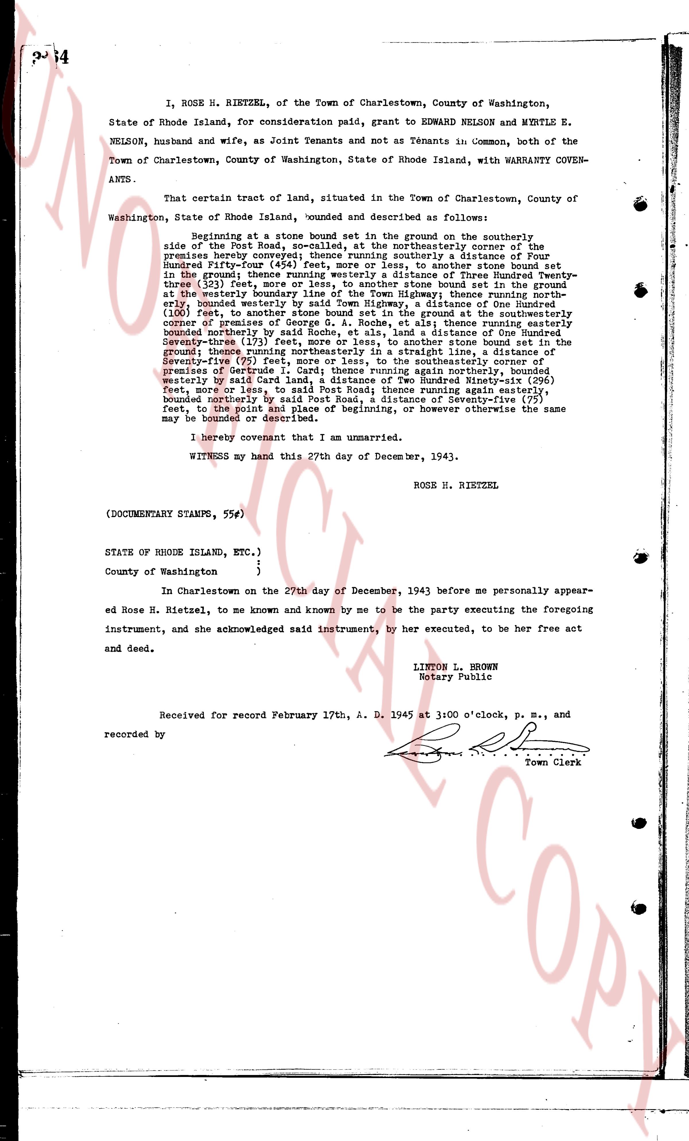
page 1

deed_walker_v1.9_2026-10-10 · the index is the town's own (i2l.uslandrecords.com); transcripts, chains and the assessor's cards are the Perry Machine's reading of it. Where the record we hold runs out, the page says so.