The instrument's own words
page 1 · read by Gemma vision
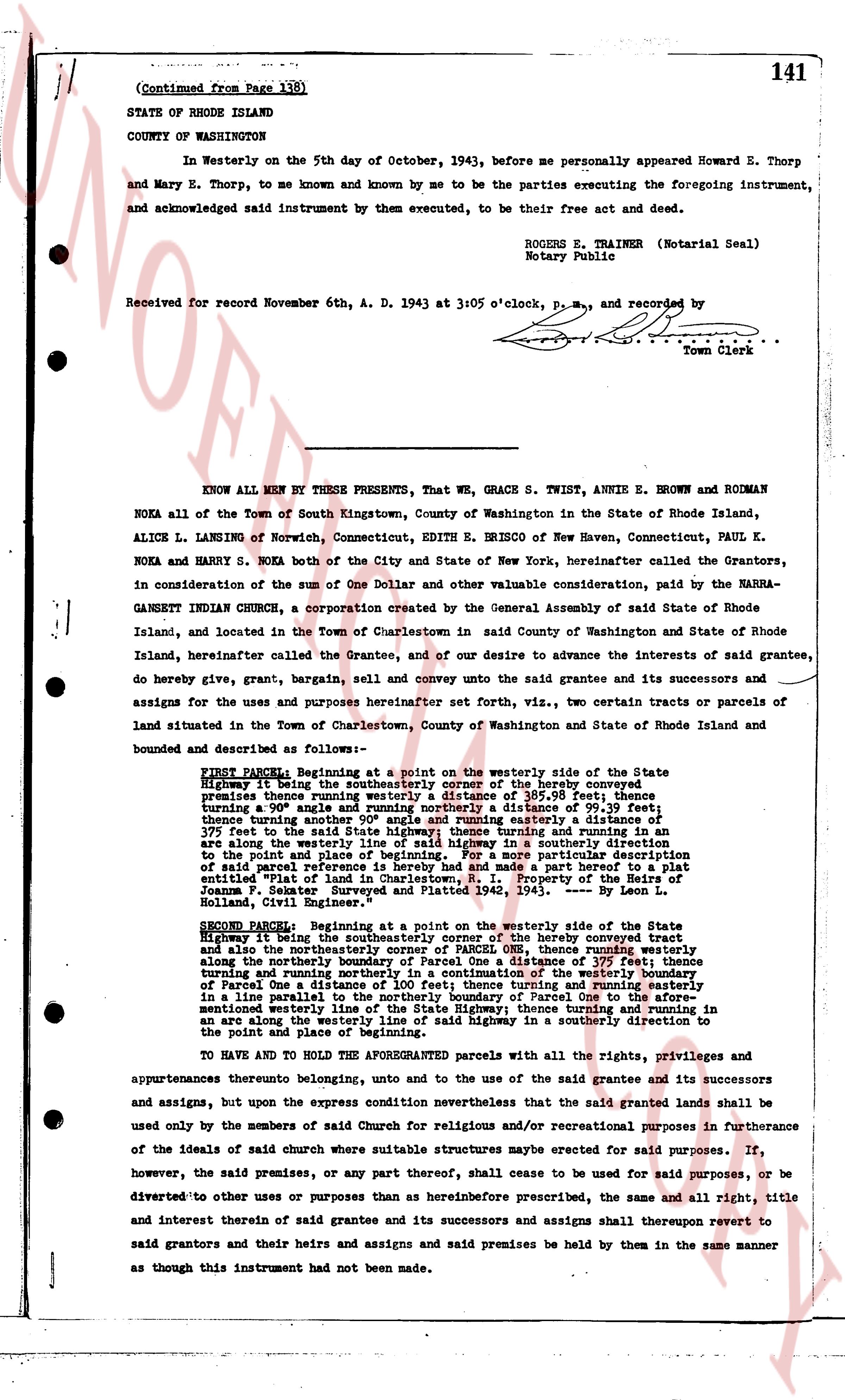
(Continued from Page 138)
141
STATE OF RHODE ISLAND
COUNTY OF WASHINGTON
In Westerly on the 5th day of October, 1943, before me personally appeared Howard E. Thorp and Mary E. Thorp, to me known and known by me to be the parties executing the foregoing instrument, and acknowledged said instrument by them executed, to be their free act and deed.
ROGERS E. TRAINER (Notarial Seal)
Notary Public
Received for record November 6th, A. D. 1943 at 3:05 o'clock, P.M., and recorded by [?]
Town Clerk
----
KNOW ALL MEN BY THESE PRESENTS, That WE, GRACE S. TWIST, ANNIE E. BROWN and RODMAN NOKA all of the Town of South Kingstown, County of Washington in the State of Rhode Island, ALICE L. LANSING of Norwich, Connecticut, EDITH E. BRISCOE of New Haven, Connecticut, PAUL K. NOKA and HARRY S. NOKA both of the City and State of New York, hereinafter called the Grantors, in consideration of the sum of One Dollar and other valuable consideration paid, by the NAURAGANNETT INDIAN CHURCH, a corporation created by the General Assembly of said State of Rhode Island, and located in the Town of Charlestown in said County of Washington and State of Rhode Island, hereinafter called the Grantee, and of our desire to advance the interests of said grantee, do hereby give, grant, sell, bargain, sell and convey unto the said grantee and its successors and assigns for the uses and purposes hereinafter set forth, viz., two certain tracts or parcels of land situated in the Town of Charlestown, County of Washington and State of Rhode Island and bounded and described as follows:—
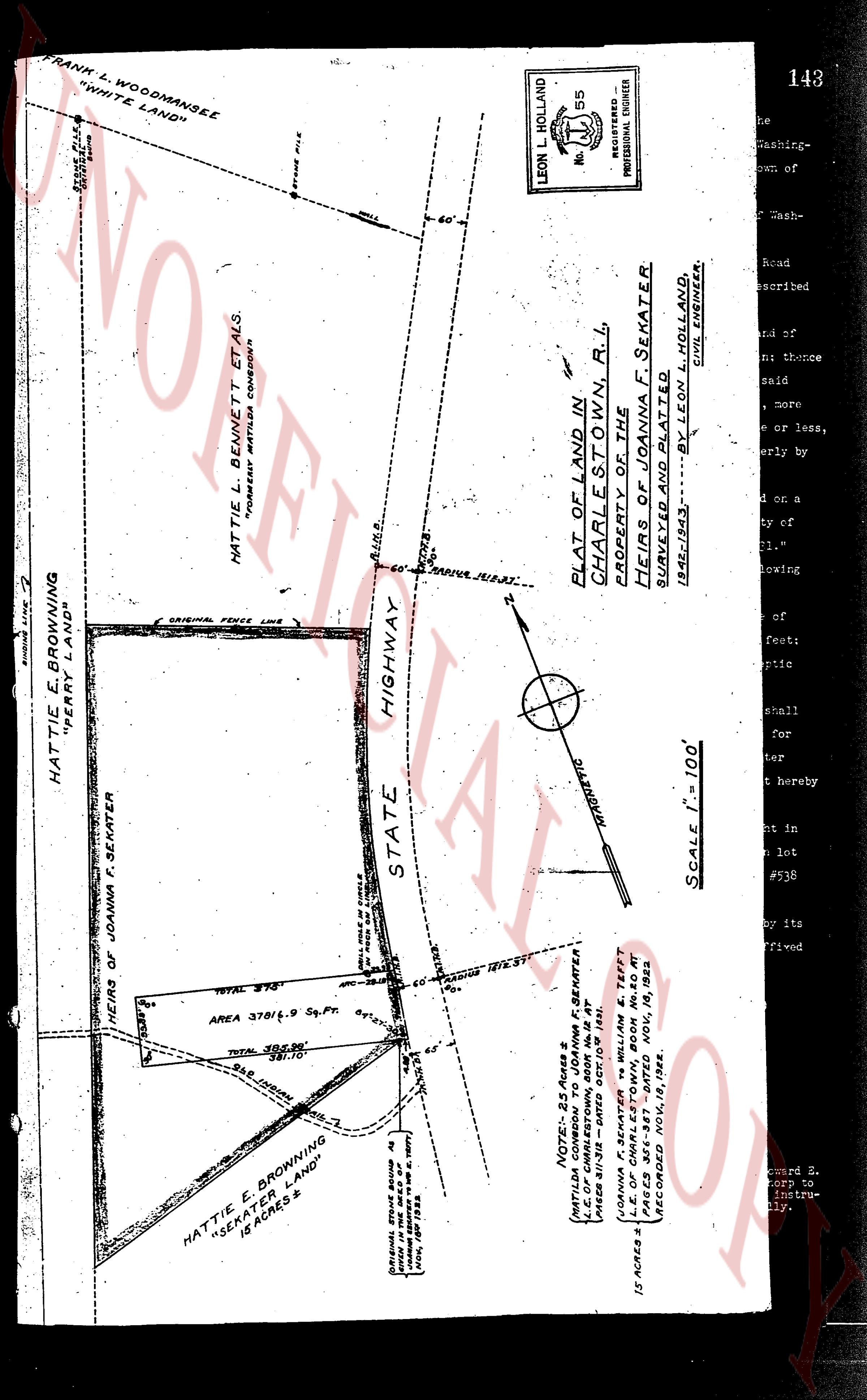
FIRST PARCEL: Beginning at a point on the westerly side of the State Highway being the southeasterly corner of the hereby conveyed premises thence running westerly a distance of 385.98 feet; thence turning a 90° angle and running northerly a distance of 99.39 feet; thence turning a 90° angle and running easterly a distance of 385.98 feet; thence turning a 90° angle and running southerly a distance of 375 feet to the said State highway; thence turning and running in an arc along the westerly side of said State highway in a southerly direction to the point and place of beginning. For a more particular description of said parcel reference is made to a map which forms a part hereof marked as "Plat of land in Charlestown, R. I. Property of the Heirs of James T. Esker. Surveyed and Platted 1942. — By — Leon L. Holland, Civil Engineer."
SECOND PARCEL: Beginning at a point on the westerly side of the State Highway being the southeasterly corner of the hereby conveyed lot ONE, thence running also along the northeasterly boundary of said Parcel One a distance of 375 feet; thence turning and running parallel to the northeasterly boundary of the westerly side of said State Highway a distance of 100 feet; thence turning and running westerly in a line parallel to the northeasterly boundary of Parcel One a distance of 375 feet to the mentioned westerly line of the State Highway; thence turning and running in an arc along the westerly side of said State highway in a southerly direction to the point and place of beginning.
TO HAVE AND TO HOLD the AFOREGRANTEDS parcels with all the rights, privileges and appurtenances thereunto belonging, unto and to the use of the said grantee and its successors and assigns, but upon the express condition nevertheless that the said granted lands shall be used only by the members of said Church for religious and/or recreational purposes in furtherance of the ideals of said church where suitable structures may be erected for said purposes. If, however, the said premises, or any part thereof, shall cease to be used for said purposes, or be diverted to other uses or purposes than as hereinbefore prescribed, the same and all right, title and interest therein of said grantee and its successors and assigns shall thereupon revert to said grantors and their heirs and assigns and said premises be held by them in the same manner as though this instrument had not been made.
page 2 · read by Gemma vision
142
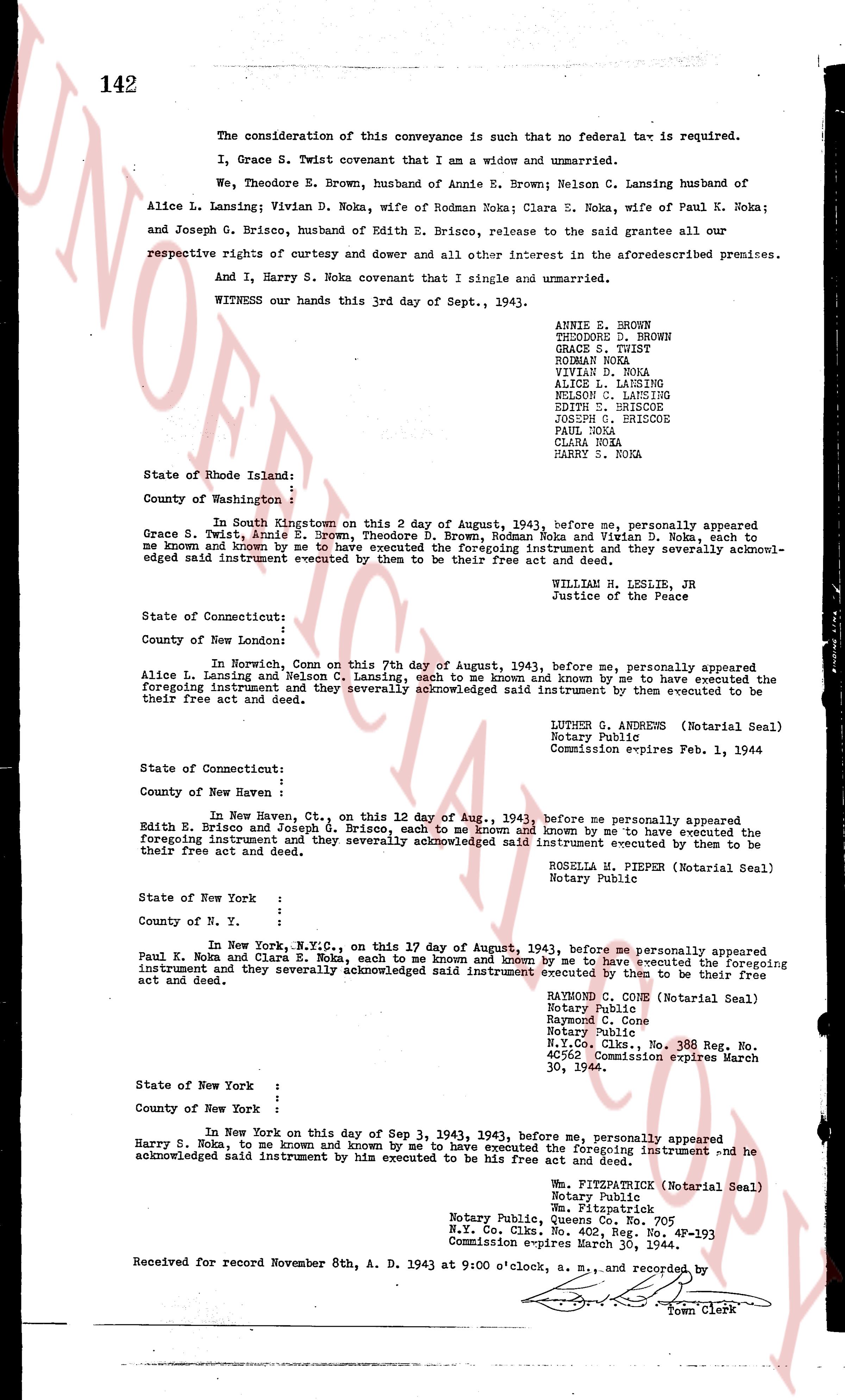
The consideration of this conveyance is such that no federal tax is required.
I, Grace S Twist covenant that I am a widow and unmarried.
We, Theodore D. Brown, husband of Annie E. Brown; Nelson C. Lansing husband of Alice L. Lansing; Vivian D. Noka, wife of Rodman Noka; Clara E. Noka, wife of Paul K. Noka; and Joseph G. Briscoe, husband of Edith E. Briscoe, release to the said grantee all our respective rights of curtesy and dower and all other interest in the aforesaid premises.
And I, Harry S. Noka covenant that I single and unmarried.
WITNESS our hands this 3rd day of Sept., 1943.
ANNIE E. BROWN
THEODORE D. BROWN
GRACE S. TWIST
RODMAN NOKA
VIVIAN D. NOKA
ALICE L. LANSING
NELSON C. LANSING
EDITH E. BRISCOE
JOSEPH G. BRISCOE
PAUL NOKA
CLARA NOKA
HARRY S. NOKA
State of Rhode Island: :
County of Washington: :
In South Kingstown on this 2 day of August, 1943, before me, personally appeared Grace S. Twist, Annie E. Brown, Theodore D. Brown, Rodman Noka and Vivian D. Noka, each to me known and known by me to have executed the foregoing instrument and they severally acknowledged said instrument executed by them to be their free act and deed.
WILLIAM R. LESLIE, JR
Justice of the Peace
State of Connecticut: :
County of New London: :
In Norwich, Conn on this 7th day of August, 1943, before me, personally appeared Alice L. Lansing and Nelson C. Lansing, each to me known and known by me to have executed the foregoing instrument and they severally acknowledged said instrument executed by them to be their free act and deed.
LUTHER G. ANDREWS (Notarial Seal)
Notary Public
Commission expires Feb. 1, 1944
State of Connecticut: :
County of New Haven : :
In New Haven, Ct., on this 12 day of Aug., 1943, before me personally appeared Edith E. Briscoe and Joseph G. Briscoe, each to me known and known by me to have executed the foregoing instrument and they severally acknowledged said instrument executed by them to be their free act and deed.
ROZELA M. PIEFEN (Notarial Seal)
Notary Public
State of New York : :
County of N. Y. : :
In New York, N.Y.C., on this 17 day of August, 1943, before me personally appeared Paul K. Noka and Clara E. Noka, each to me known and known by me to have executed the foregoing instrument and they severally acknowledged said instrument executed by them to be their free act and deed.
RAYMOND C. CONE (Notarial Seal)
Notary Public
Raymond C. Cone
Notary Public
N.Y. Co. Clks., No. 308, Reg. No.
40562 Commission expires March 30, 1944
State of New York : :
County of New York : :
In New York on this day 3 Sep 1943, 1943, before me, personally appeared Harry S. Noka, to me known and known by me to have executed the foregoing instrument and he acknowledged said instrument by him executed to be his free act and deed.
Wm. FITZPATRICK (Notarial Seal)
Notary Public
Wm. Fitzpatrick
Notary Public, Quant. Co., No. 705
N.Y. Co. Clks., No. 402, Reg. No. 4P-193
Commission expires March 30, 1944.
Received for record November 8th, A. D. 1943 at 9:00 o'clock, a. m., and recorded by [?]
Town Clerk
page 3 · read by Gemma vision
[NOT OFFICIAL]
HATTIE E. BROWNING
"PERRY LAND"
FRANK L. WOODMANSEE
"WHITE LAND"
HATTIE L. BENNETT ET ALS.
"FORMERLY MATILDA CONDON"
PLAT OF LAND IN
CHARLESTOWN, R.I.
PROPERTY OF THE
HEIRS OF JOANNA F. SEKATER
SURVEYED AND PLATTED
1943------BY LEON L. HOLLAND,
CIVIL ENGINEER.
LEON L. HOLLAND
R.E. No. 55
REGISTERED
PROFESSIONAL ENGINEER
STATE HIGHWAY
MAGNETIC
SCALE 1" = 100'
HATTIE E. BROWNING
"SEKATER LAND"
10 ACRES +/-
AREA 37814.9 Sq. Ft.
TOTAL 378'
TOTAL 381.00'
381.10'
NOTE: 2.5 Acres from MATILDA F. SEKATER
L.C. OF CHARLESTOWN, born Nov. 11th At
L.C. OF CHARLESTOWN, died Nov. 18th At
L.C. OF CHARLESTOWN, "WILLING E. TEFFT"
L.E. OF CHARLESTOWN, Book No. 88 At
Page 141, filed Nov. 18th, 1923,
RECORDED Nov. 18th, 1923.
15 ACRES +/-
ORIGINAL STONE BOUNDS As
shown on the map of the
Town of Charlestown in 1877.
(Book 131 Page 134)
HEIRS OF JOANNA F. SEKATER
The page as recorded