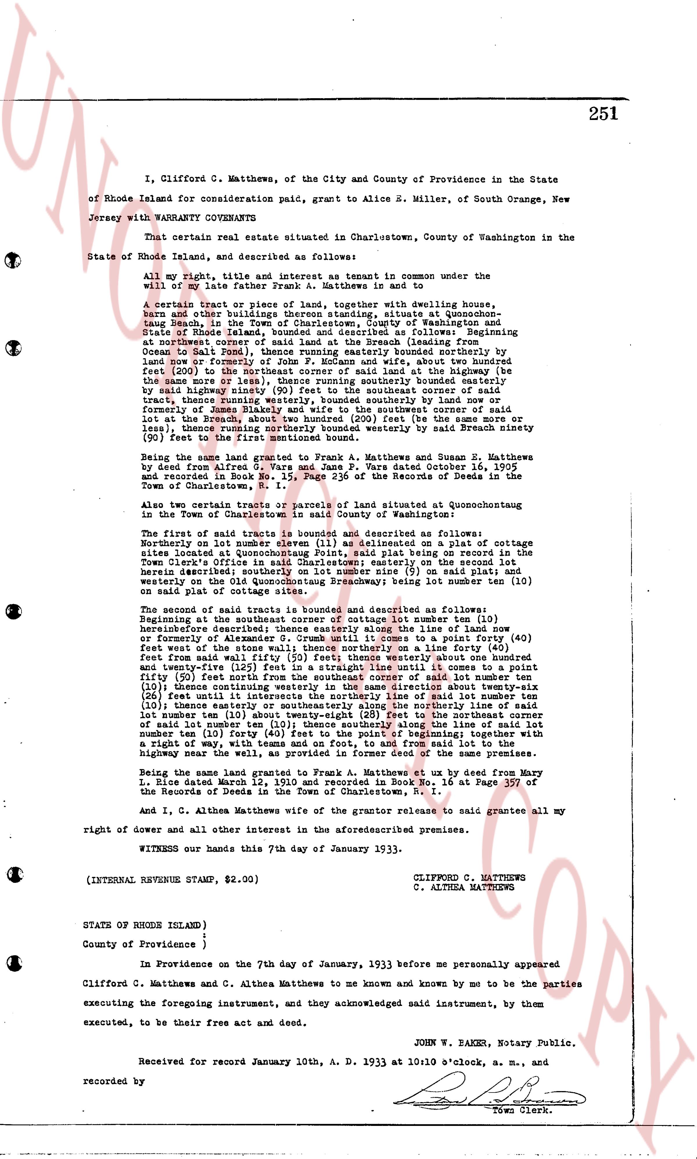
The instrument's own words
page 1
251
I, Clifford C. Matthews, of the City and County and Province in the State
of Rhode Island for consideration paid, grant to Alice B. Miller, of South Orange, New
Jersey with WARRANTY COVENANTS
That certain real estate situated in Charlestown, County of Washington in the
State of Rhode Island, and described as follows:
All my right, title and interest as tenant in common under the
will of my late father Frank A. Matthews, in and to
A certain tract or piece of land, together with dwelling house,
barn and other buildings thereon, all standing unity, situated at Quonsetochant
Beach, in the Town of Charlestown, County of Washington and State
of Rhode Island, which said land is bounded as follows: Beginning at
northport corner of said land at the Beach (leading from
Ocean Street to the beach) then running easterly marked boundary westerly on
land now or formerly of John P. McKenna and wife, about two hundred
feet (200) to the northeast corner of said land at the highway (be
the same corner or not) then running southerly marked boundary easterly on
said highway ninety (90) feet to the southeast corner of said tract
of land, thence running southwesterly marked boundaries by a hand row or
formerly of James Blakey and wife to the southwest corner of said
lot at the highway, thence running northerly (500) feet (be the same corner or
less), thence running northerly marked boundary westerly by said Breach ninety
feet (90) to the beginning here first described.
Being the same land granted to Frank A. Matthews and Susan E. Matthews
by deed from Alfred G. Vane and Jane F. Vane dated October 16, 1905
and recorded in Book M No. 1 Page 256 of the Records of Deeds in the
Town of Charlestown, R. I.
Also two certain tracts or pieces of land situated at Quonsetochant
in the Town of Charlestown, in said County of Washington:
The first of said tracts is bounded and described as follows:
Northerly on lot number eleven (11) as delineated on a plat or cottage
sites located at Quonsetochant Beach, said plat being on record in the
Town Clerk's Office in Charlestown easterly; easterly on the second lot
marked boundary outlined on said plat size (9) said plats and
westerly on the old Quonsetochant Broadway; being most lot number twelve (12)
on said plat of cottage sites.
The second of said tracts is bounded and described as follows:
Beginning at the southern corner of cottage lot number ten (10)
henceforth described; thence easterly along the line of said lot number
ten (10) forty feet until it comes to a point a forty (40)
feet west of the stone wall; thence northerly on a line a forty (40)
feet west of the stone wall ninety (90) feet to the northeast corner of said lot number
and twenty-five (25) feet in a straight line until it comes to a point
thirty (30) feet east of the northeast corner of said lot number ten (10)
thence continuing westerly in the same direction about twenty-six
(26) feet until it comes to the northeast line of said lot number ten
(10); thence easterly or southeasterly along the northerly line of said lot
number ten (10) thirty (30) feet to the northeast corner of said
number ten (10); thence southerly the line of said lot number
ten (10) and lot twelve (12) forty (40) feet to the beginning, said land
a right of way, with teams and on foot, from and said lot to the
highway near the wall, as in former deed of the same premises.
Being the same land granted to Frank Matthews at ux by deed from Mary
L. Dice dated March 12, 1910 and recorded in Book No. 16 at Page 357
of the Records of Deeds in the Town of Charlestown, R. I.
And I, C. Althea Matthews the grantor release to said grantee all my
right of dower and all other interest in the aforesaid premises.
WITNESS our hands this 7th day of January 1933.
(INTERNAL REVENUE STAMP, $2.00)
CLIFFORD C. MATTHEWS
C. ALTHEA MATTHEWS
STATE OF RHODE ISLAND)
County of Providence )
In Providence on the 7th day of January, 1933 before me personally appeared
Clifford C. Matthews and C. Althea Matthews to me known and known by me to be the parties
executing the foregoing instrument, and they acknowledged said instrument, by them
executed, to be their free act and deed.
JOHN W. BAKER, Notary Public.
Received for record January 10th, A. D. 1933 at 10 o'clock a. m., and
recorded by [Signature]
Town Clerk.
page 2
349
(b) Also that certain lot or parcel of land lying between the Shelter Harbor property
line as designated and delineated on the aforesaid map and the Post Road, so-called, which is
marked on said map as "Private Property of Dr. Franklin D. Lawson."
(c) Also a tract of land lying North of the Post Road, aforesaid, generally known
as the Perkins Farm, containing forty and one-half acres, more or less, particularly
described in a deed recorded in the Land Records of said Town of Westerly, in Book No. 42,
and Page 400, and in the Land Records of said Town of Charlestown, in Book No. 18, at page
147.
(d) Also a tract of land lying North of the Post Road aforesaid, generally known
as the Alner Browning Farm particularly described in a deed recorded in the Land Records of
said Town of Westerly, in Book No. 49, at page 11, and containing approximately one hundred
sixty-three acres of land.
(e) Also all driveways, parks, square, groves, forests, dunes and the beach lying
south thereof as designated and delineated on the aforesaid maps and also all land conveyed
to this grantor by deed from this grantee of even date herewith and also including Symphony
Beach extending from line marked "Westpawuk" easterly to line marked "U. S. Life Station,"
containing about forty-five hundred (4500) linear feet of ocean beach.
(f) Also that certain lot or parcel of land adjacent to and just north of the
Dunes designated on said map as "Private property of Dr. Franklin D. Lawson," bounded on
the east by a line parallel and four hundred (400) feet west of the division line of the
Towns of Westerly and Charlestown running from a point where said parallel line intersects
said Dunes in a generally western direction four hundred (400) feet bounded on the south by
said Dunes and the Atlantic Ocean, thence turning at an angle of approximately ninety (90°)
degree and running in a general northerly direction including and including the parcel marked Madrigal
Island and all beach and beach lots shown on said map.
Meaning and intending hereby to convey to said mortgagee all and singular the
parcels of land mentioned and described in two deeds from Shelter Harbor Corporation to
the mortgagor herein, the first of which said deeds is dated the 16th day of December, A. D.
1926 and is recorded in Land Evidence Records in said Westerly in Book 53 at pages 139 to 140,
Charlestown Book 24 page 54, and the second of said deed being dated the 26th day of June
A. D. 1928 and recorded in said Land Evidence Records of said Westerly in Book 53 at page 141,
Charlestown Book 24, page 56, and which said properties are delineated and marked out on "Map
of Shelter Harbor formally known and recorded as Muscutuxly (name changed March 1st, 1918)
property of Franklin D. Lawson Towns of Westerly, R. I. engraved by the Williams Map and Guide
Co. from a survey made in 1912 by George W. Woodard, scale 400 feet to the inch and which
said map is recorded in said Land Evidence Records of said Westerly in Book 53 at page 140;
and which said properties are also shown on "Map of Bungalow Sites Called Musicality Property
of Dr. Franklin D. Lawson, in the Town of Westerly, Rhode Island, 1912, scale 200 feet to an
inch by George W. Woodward" which said map is contained in two sheets, sheet two of which is
recorded on page 65 from Plat Book No. 2 in said Westerly and sheet one of which is recorded in
Plat Book No. 2 at page 88, as well as all other land owned by said mortgagor and in any way
herein referred to by plat or otherwise.
The above described premises are conveyed subject to mortgages restrictions, ease-
ments, and attachments of record.
TO HAVE AND TO HOLD, the said granted and bargained premises, with all the privileges,
and appurtenances to the same belonging, or in any wise appertaining to the said grantee, its
successors and assigns, forever.
page 3
351
STATE OF RHODE ISLAND
COUNTY OF WASHINGTON
In Westerly on the 20th day of May, A. D. 1933, before me personally appeared
Benjamin F. Moulton and Walter K. Pullen, to me known, and known by me to be the President
and Treasurer respectively of Shelter Harbor Country Club, and they acknowledged said
above instrument by them executed for and in behalf of said Shelter Harbor Country Club, to
be their individual and official free act and deed, and the free act and deed of said cor-
poration.
S. EVERETT WILKINS, JR.
Notary Public.
Received for record September 2nd, A. D. 1933, at 3:00 o'clock, p. m., and
recorded by [Signature]
Town Clerk.
The page as recorded