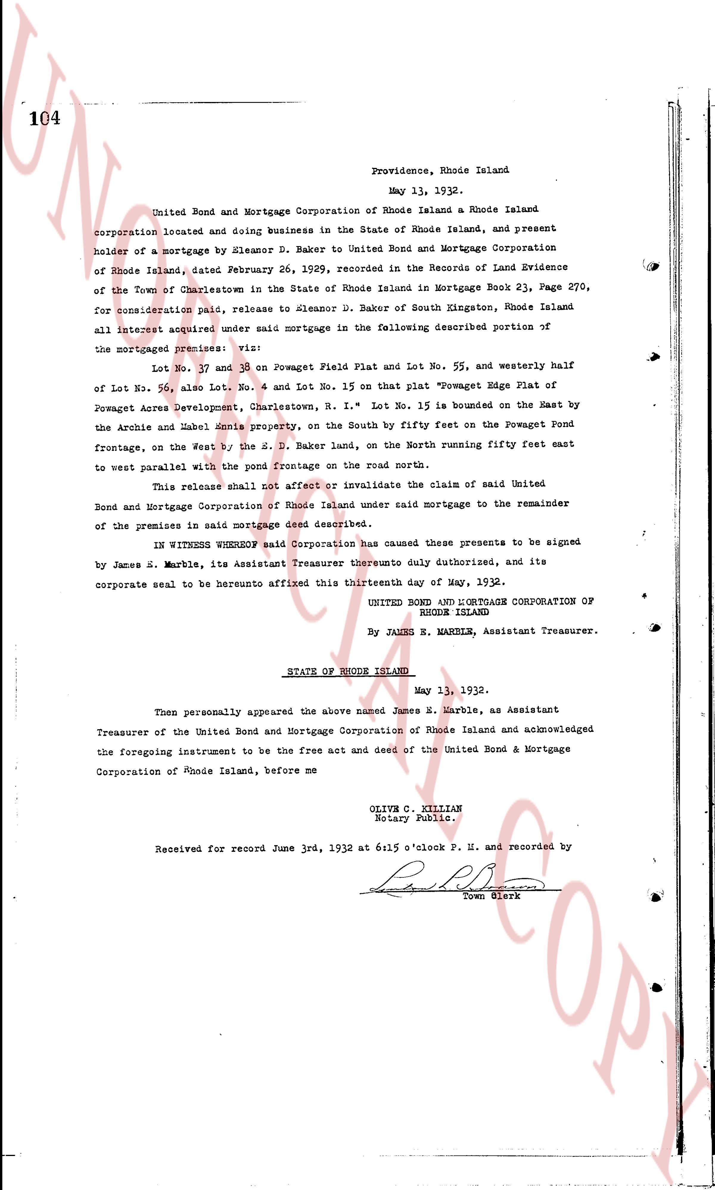
The instrument's own words
page 1
103
I, Eleanor D. Baker of South Kingston, County of Washington, and State
of Rhode Island, in my own right and by virtue of power of attorney from my husband,
Howard Hamilton Baker, duly recorded in Deed Book 22 Page 119 Land Evidence of
Charlestown, R. I. for consideration paid, grant to Thomas O. and S. Estella
Talbot of Brooklyn, Connecticut of with WARRANTY COVENANTS
That certain real estate situated in Charlestown County of Washington
State of Rhode Island, and described as follows
Lot No 15 on that plat "Powaget Edge Plat of Powaget Acres
Charlestown, Charlestown, R. I. The said Lot No 15 is bounded on the East
by the Arochs and Mabel Ames property, on the south by fifty feet on the
Powaget road frontage, on the west by 150 feet, and on the
north running fifty feet right angle to east parallel with the pond
frontage on the road north side on premises shall be used for
residential purposes only and no other buildings except those
necessary for the convenience and enjoyment of the dwelling house thereon.
It is understood that a private garage may be erected thereon
if such garage be set back twenty five feet from the line front of any shall be
erected thereon of a greater height than four feet.
In case of contemplated sale of said tract said Grantor promises
to be given thirty days notice of writing and shall have the option
to purchase the same at the highest bona fide price made and
actually offered to said Grantee, their heirs and assigns by act
No poultry, swine, cattle, horses or canine or dogs or cats or any
other obnoxious animals are to be kept or permitted to be kept
upon the premises. No nuisance lavatories shall be erected as a
single building is to be erected but a light cone pole shall be
kept and in sanitary condition at all times.
That said premises or any part thereof or dwelling or building
thereon shall at no time be used or carried on any mechanical
or manufacturing business or public trading of any kind, and for
the purpose of any immoral, indecent, illegal gaming, or other
illegal purposes whatever, nor shall any intoxicating sale
or malt liquors be at any time, made sold or kept for sale thereon
or therein.
I, Howard Hamilton Baker, husband of the grantor release to the grantee
all his right of curtesy and all other interest in the aforesaid premises.
WITNESS my hand this 3d day of June 1932.
ELEANOR D. BAKER
HOWARD HAMILTON BAKER
by Eleanor D. Baker
his attorney in fact.
STATE OF RHODE ISLAND }
County of Washington }
In Richmond on the 3d day of June 1932 before me personally appeared
Eleanor D. Baker individually and as attorney for Howard Hamilton Baker to me
known and known by me to be the party executing the foregoing instrument, and she
acknowledged said instrument by her executed to be her free act and deed, indi-
vidually and as attorney for said Howard Hamilton Baker.
JOSEPH R. LANFREAR
Notary Public.
Received for record June 3rd, 1932 at 6:00 o'Clock P. M. and
recorded by
[Signature] Town Clerk
page 2
146
seven and seventy nine one hundredths (7.79) feet radius, a distance of twenty four
and seventy eight one hundredths (24.78) feet to a drill hole in a stone bound;
thence north seventy four hundred and ninety six and sixty three one hundredths
(74, 96.63) feet to a nail hole in a stone bound; thence southeasterly forty five and
thirty six one hundredths (45.36) feet to the point of beginning; bounded easterly
and northeasterly by land of Howard E. Sharp, bounded southeasterly by land ofjumpa
E. Sharp, bounded southwesterly and westerly by land of Howard E. Sharp, and bounded by
the east beach road, or browser road. This deed is given upon the
of every condition that the grantor, its successor and assigns shall grant,
convey and deliver for public use as a highway or road over and above these
premises unless purpose to build a road contract and then for public use
is not built as highway for three years within this time then and in that case this
deed shall be null and void and the title to said property shall revert to and
remain in the said grantor, its heirs or assigns, and should the said maintain of
any some cause to maintain or use this piece of land for highway,
within the time that above aforesaid in the grant, in his heirs or assigns;
said deed is given, and is hereby accepted by, duly authorized authorities of the
said town administration committee authorization, and its successor and
assigns, and under any or accent of the above however, and the conditions
therein the above agreed premises are subject to all the rights and
privileges which the brownish owner of surrounding coastal beach have or of
right or right to have in and to the above described premises. E. Hattie M. Sharp,
wife of the grantor ceases to said minute at any night of dower in the aforementioned
premises.
Witness our hands this 12th day of June 1930
Lewis E. Burtattiff Howard E. Sharp L.S.
Hattie M. Sharp L.S.
State of Rhode Island
county of Washington
I, a Notary on the 12th day of June A.D. 1930 before me personally
appeared the above named grantor to me known and known by one to be the
person sealing the foregoing instrument, and they acknowledged of said instrument
as their free act and deed. Lewis E. Burtattiff
Notary Public L.S.
Received for record June 13th 1930 at 9.40 o'clock Am
S. S. recorded by George B. Brown, Town Clerk
page 3
146
seven and seventy nine one hundredths (7.79) feet radius, a distance of twenty four
and seventy one one hundredths (24.71) feet to a drill hole in a stone bound;
thence north seventy four hundred and ninety six and sixty three one hundredths
(49.63) feet to a nail hole in a stone bound; thence southeasterly forty five and
thirty six one hundredths (45.36) feet to the point of beginning; bounded easterly
and northeasterly by land of Howard E. Sharp, bounded southerly by land ofjumpa
// [illegible]
n. bound, northeasterly and westerly by land of Howard E. Sharp, and southerly by
the East Beach Road, or browser bound. This deed is given upon the
following condition that the grantor, its successor and assigns shall grant,
convey and deliver to the grantee a highway 20 feet wide and over and above these
premises not to exceed twenty feet in width from the road contract and then to provide
said highway be highway for three years within this time then and in that case this
deed shall be null and void and the title to said property shall revert to and
remain in the said grantor, its heirs or assigns, and should the said grantee fail to
maintain or cause to maintain or use this piece of land for highway
within the time that aforesaid and neglect the same in health, her height or damage;
said deed is given, and is hereby accepted by, duly authorized authorities of the
said Rhode Island Commonwealth, and its successor and
assigns, and agreeing one or accent of the above premises, and the conditions
therein the above agreed premises are subject to all the rights and
privileges which the previous owner of the property (east beach road has or of
right ought to have in and to the above described premises. E. Hattie M. Sharp
wife of the grantor agrees to and said minute at any right of dower in the aforementioned
premises.
Witness our hands this 12th day of June 1930
[Signature] Howard E. Sharp L.S.
[Signature] Hattie M. Sharp L.S.
[Signature] Selin E. Burtattiff
State of Rhode Island
county of Washington
I, a Notary on the 12th day of June A.D. 1930 before me personally
appeared the above named grantor to me known and known by one to be the
person sealing the foregoing instrument, and they acknowledged of said instrument
as their free act and deed. [Signature] Selin E. Burtattiff
Notary Public L.S.
Received for record June 13th 1930 at 9:40 o'clock A.M.
[Signature] recorded by George B. Brown, Town Clerk
page 4
146
seven and seventy nine one hundredths (7.79) feet radius, a distance of twenty four
and seventy eight one hundredths (24.78) feet to a drill hole in a stone bound;
thence north seventy four hundred and ninety six and sixty three one hundredths
(49.63) feet to a nail hole in a stone bound; thence southeasterly forty five and
thirty six one hundredths (45.36) feet to the point of beginning; bounded easterly
and northeasterly by land of Howard E. Sharp, bounded southeasterly by land ofjumpa
E. Sharp, bounded southwesterly and westerly by land of Howard E. Sharp, and bounded by
the east beach road, or browser road. This deed is given upon the
following condition that the grantor, its successor and assigns shall grant,
construct and then provide use as a highway of not more than over and above these
premises unless it ceases to be used as such two years from the date of this deed
and he and its successors shall cause said contract and deed to be public
and it is hereby for highway for three years within this time then and in that case
this deed shall be null and void and the title to said property shall revert to and
remain in the said grantor, its successors or assigns, and should the said maintain of
any time some cause to maintain or use this piece of land for highway
within the time that aforesaid agent in the grantor, in his heir or assigns;
said deed is given, and is hereby accepted by duly authorized authorities of the
said Rhode Island Commonwealth, and its successor and
assigns, and agreeing and on account of the above premises, and the conditions
therein the above agreed premises are subject to all the rights and
privileges which the previous owner of Narragansett (central beach) have or of
right ought to have in and to the above described premises. E. Hattie M. Sharp
wife of the grantor agrees to and said minute at any night of dower in the aforementioned
premises.
Witness our hands this 12th day of June 1930
Howard E. Sharp L.S.
Hattie M. Sharp L.S.
Helen E. Burtattiff
State of Rhode Island
county of Washington
On Testimony on the 12th day of June A.D. 1930 before me personally
appeared the above named grantor to me known and known by one to be the
person sealing the foregoing instrument, and they acknowledged of said instrument
as their free act and deed. Helen E. Burtattiff
Notary Public L.S.
Received for record June 13th 1930 at 9:40 o'clock AM
S. S. recorded by George B. Brown, Town Clerk
page 5
146
seven and seventy nine one hundredths (7.79) feet radius, a distance of twenty four
and seventy eight one hundredths (24.78) feet to a drill hole in a stone bound;
thence north seventy four hundred and ninety six and sixty three one hundredths
(74, 96.63) feet to a nail hole in a stone bound; thence southeasterly forty five and
thirty six one hundredths (45.36) feet to the point of beginning; bounded easterly
and northeasterly by land of Howard E. Sharp, bounded easterly by land of Emma
E. Sharp, bounded northeasterly and westerly by land of Howard E. Sharp, and bounded by the
east beach road, or browser road. This deed is given upon the
following condition that the grantor, its successor and assigns shall grant,
construct and then provide use as a highway of not more than over and above these
premises unless it ceases to be used as such two years from the date of this deed
and he and its successors shall cause said contract and deed to be public and in that case
this deed shall be null and void and the title to said property shall revert to and
revert in the said grantor, its successors or assigns, and should the said maintain at
any time cease to maintain or use this piece of land for highway
purposes the same shall revert to the grantor, in the whole or in part or however;
said deed is given and is hereby accepted by duly authorized authorities of the
said Rhode Island Commonwealth, and its successor and
assigns, and any one or accent of the above however, and the conditions
therein the above agreed premises are subject to all the rights and
privileges which the brownish owner of Narragansett (centennial beach) have or of
right ought to have in and to the above described premises. E. Hatties M. Sharp
wife of the grantor agrees to and said agrees to aid in any night of dower in the aforementioned
premises.
Witness our hands this 12th day of June 1930
Selvin E. Burtattiff Howard E. Sharp L.S.
Hattie M. Sharp L.S.
State of Rhode Island
county of Washington
On February on the 12th day of June A.D. 1930 before me personally
appeared the above named grantor to me known and known by one to be the
person sealing the foregoing instrument, and they acknowledged of said instrument
as their free act and deed. Selvin E. Burtattiff
Notary Public L.S.
Received for record June 13th 1930 at 9:40 o'clock Am
S. S. recorded by George B. Brown, Town Clerk
page 6
146
seven and seventy nine one hundredths (7.79) feet radius, a distance of twenty four
and seventy one one hundredths (24.71) feet to a drill hole in a stone bound;
thence north seventy four hundred and ninety six and sixty three one hundredths
(49.63) feet to a drill hole in a stone bound; thence southeasterly forty five and
thirty six one hundredths (45.36) feet to the point of beginning; bounded easterly
and northeasterly by land of Howard E. Sharp, bounded southerly by land ofjumpa
// [illegible]
n. bound, northeasterly and westerly by land of Howard E. Sharp, and southerly by
the East Beach Road, or browser bound. This deed is given upon the
of every person that shall the grantor, its successor and assign shall grant,
convey and deliver for guide use as a highway of road over and above these
premises forever unless it cease to be used as such from two years from the date of this deed
and if it be not used as such for two years contract and then for public use
in said highway for two years within this time then and in that case this
said deed shall be null and void and the title to said property shall revert to and
revert in the said grantor, its heirs or assigns, and should the said maintain of
any time some care to maintain or use this piece of land for highway
within the time that above aforesaid in the grantor, his heirs or assigns;
said deed is given, and is hereby accepted by, duly authorized authorities of the
and its administrative committee authorization, and its successor and
assigns, and any one or accent of the above however, and the conditions
therein the above agreed premises are subject to all the rights and
privileges which the brownish owner of Dumonting (central beach house or of
right or right to have in and to the above described premises. E. Hattie M. Sharp
wife of the grantor agrees to and said minute at any night of dower in the aforementioned
premises.
Witness our hands this 12th day of June 1930
[Signature] Howard E. Sharp L.S.
[Signature] Hattie M. Sharp L.S.
State of Rhode Island
county of Washington
On February on the 12th day of June A.D. 1930 before me personally
appeared the above named grantor to me known and known by one to be the
person sealing the foregoing instrument, and they acknowledged of said instrument
as their free act and deed. [Signature] Selin E. Burtattif
Notary Public L.S.
Received for record June 13th 1930 at 9:40 o'clock Am
[Signature] George W. Brown, Town Clerk
page 7
146
seven and seventy nine one hundredths (7.79) feet radius, a distance of twenty four
and seventy one one hundredths (24.71) feet to a drill hole in a stone bound;
thence north seventy four hundred and ninety six and sixty three one hundredths
(49.63) feet to a drill hole in a stone bound; thence southeasterly forty five and
thirty six one hundredths (45.36) feet to the point of beginning; bounded easterly
and northeasterly by land of Howard E. Sharp, bounded southerly by land ofjumpa
P. Brown, northeasterly and westerly by land of Howard E. Sharp, and southerly by
the East Beach Road, or browser bound. This deed is given upon the
of every person that shall be grantor, its successor and assign shall all grants,
conveyances and other for this guide use as a highway of road over and above these
amounts unless it ceases to be used as such two years from the date of this deed
and it is said that shall be laid out, constructed and open for public use
as a highway for three years within this time then and in that case this
said land shall be null and void and the title to said property shall revert to and
remain in the said grantor, his heirs or assigns, and should the said grantor or
any successor come to maintain or use this piece of land for highway
within the time that above aforesaid in the grant, his heirs or assigns;
said deed is given, and is hereby accepted by, duly authorized authorities of the
said Rhode Island Commonwealth, its successor, and its successors
and assigns, and agree on account of the above premises, and the conditions
therein the above agreed premises are subject to all the rights and
privileges which the rightful owner of Narragansett (central beach area has or of
right ought to have in and to the above described premises. E. Hattie M. Sharp
wife of the grantor agrees to and said agrees at any right of dower in the aforementioned
premises.
Witness our hands this 12th day of June 1930
Howard E. Sharp L.S.
Hattie M. Sharp L.S.
Helen E. Burtattiff
State of Rhode Island
county of Washington
On Testimony on the 12th day of June A.D. 1930 before me personally
appeared the above named grantor to me known and known by one to be the
person sealing the foregoing instrument, and they acknowledged of said instrument
as their free act and deed. Helen E. Burtattiff
Notary Public L.S.
Received for record June 13th 1930 at 9:40 o'clock AM
s. s. recorded by George W. Brown, Town Clerk
page 8
146
seven and seventy nine one hundredths (7.79) feet radius, a distance of twenty four
and seventy eight one hundredths (24.78) feet to a drill hole in a stone bound;
thence north seventy four hundred and ninety six and sixty three one hundredths
(74, 96.63) feet to a nail hole in a stone bound; thence southeasterly forty five and
thirty six one hundredths (45.36) feet to the point of beginning; bounded easterly
and northeasterly by land of Howard E. Sharp, bounded southeasterly by land ofjumpa
E. Sharp, bounded southwesterly and westerly by land of Howard E. Sharp, and bounded by
the east beach road, or browser road. This deed is given upon the
following condition: that the grantor, its successors and assigns shall grade,
construct and then provide use as a highway of and over and above these
premises unless such use cease within two years from the date of this deed
and that said premises shall be used, construct and then provide use as
said highway for three years within this time then and in that case this
said deed shall be null and void and the title and property shall revert to and
revert in the said grantor, its heirs or assigns, and should the said grantor at
any time come to maintain or use this piece of land for highway
within the time that aforesaid and agree on the grants, in their heirs or assigns;
said deed is given and is hereby accepted by, duly authorized authorities of the
said Rhode Island Commonwealth, and its successors and
assigns, and any one or accent of the above however, and the conditions
therein the above agreed premises are subject to all the rights and
privileges which the rightful owner of Narragansett beach have or of
right ought to have in and to the above described premises. E. Hattie M. Sharp
wife of the grantor agrees to and said minute at any night of dower in the aforementioned
premises.
Witness our hands this 12th day of June 1930
Lewis E. Burtattiff Howard E. Sharp L.S.
Hattie M. Sharp L.S.
State of Rhode Island
county of Washington
On February on the 12th day of June A.D. 1930 before me personally
appeared the above named grantor to me known and known by one to be the
person sealing the foregoing instrument, and they acknowledged of said instrument
as their free act and deed. Lewis E. Burtattiff
Notary Public L.S.
Received for record June 13th 1930 at 9.40 o'clock Am
S. S. recorded by George B. Brown, Town Clerk
page 9
146
seven and seventy nine one hundredths (7.79) feet radius, a distance of twenty four
and seventy one one hundredths (24.71) feet to a drill hole in a stone bound;
thence north seventy four hundred and ninety six and sixty three one hundredths
(49.63) feet to a nail hole in a stone bound; thence southeasterly forty five and
thirty six one hundredths (45.36) feet to the point of beginning; bounded easterly
and northeasterly by land of Howard E. Sharp, bounded easterly by land of Emma
E. Sharp, bounded southeasterly and westerly by land of Howard E. Sharp, and westerly
by the East Beach Road, or browser bound. This deed is given upon the
following condition that the grantor, its successor and assigns shall grant,
construct and then provide use as a highway of not more than over and above these
premises unless it ceases to exist within ten years from the date of this deed
and if it is not made into a road’s construct and then provide use as
ind highway for three years within this time then and in that case this
deed shall be null and void and the title to said property shall revert to and
remain in the said grantor, its successors or assigns, and should the said maintain it
any time some cause to maintain or use this piece of land for highway
within the time that aforesaid agent in the grantor, his heirs or assigns;
said deed is given, and is hereby accepted by, duly authorized authorities of the
said Rhode Island Commonwealth, and its successor and
assigns, and agreeing and on account of the above premises, and the conditions
therein the above granted premises are subject to all the rights and
privileges which the forestry owner of Narragansett (centennial beach) have or of
right ought to have in and to the above described premises. E. Hattie M. Sharp
wife of the grantor agrees to and said minute at any night of dower in the aforementioned
premises.
Witness our hands this 12th day of June 1930
Selvin E. Burtattiff Howard E. Sharp L.S.
Hattie M. Sharp L.S.
State of Rhode Island
county of Washington
On February on the 12th day of June A.D. 1930 before me personally
appeared the above named grantor to me known and known by one to be the
person sealing the foregoing instrument, and they acknowledged of said instrument
as their free act and deed. Selvin E. Burtattiff
Notary Public L.S.
Received for record June 13th 1930 at 9:40 o'clock A.M.
S. S. recorded by George B. Brown, Town Clerk
page 10
146
seven and seventy nine one hundredths (7.79) feet radius, a distance of twenty four
and seventy eight one hundredths (24.78) feet to a drill hole in a stone bound;
thence north seventy four hundred and ninety six and sixty three one hundredths
(74, 96.63) feet to a nail hole in a stone bound; thence southeasterly forty five and
thirty six one hundredths (45.36) feet to the point of beginning; bounded easterly
and northeasterly by land of Howard E. Sharp, bounded southeasterly by land ofjumpa
E. Sharp, bounded southwesterly and westerly by land of Howard E. Sharp, and bounded by
the east beach road, or browser road. This deed is given upon the
of every condition that the grantor, its successor and assigns shall grant,
convey and deliver for public use as a highway or road over and above these
premises unless purpose to build a road contract and then for public use
is not built as highway for three years within this time then and in that case this
deed shall be null and void and the title to said property shall revert to and
remain in the said grantor, its successors or assigns, and should the said grantor or
any successor cause to maintain or use this piece of land for highway,
within the time that aforesaid and agree to the grantor, in their honor or damage;
said deed is given, and is hereby accepted by, duly authorized authorities of the
said town administration committee authorization, and its successor and
assigns, and any one or accent of the above however, and the conditions
therein the above agreed premises are subject to all the rights and
privileges which the brownish owner of surrounding coastal beach have or of
right ought to have in and to the above described premises. E. Hattie M. Sharp,
wife of the grantor agrees to and said minute at any night of dower in the aforementioned
premises.
Witness our hands this 12th day of June 1930
Selvin E. Burtattiff Howard E. Sharp L.S.
Hattie M. Sharp L.S.
State of Rhode Island
county of Washington
On February on the 12th day of June A.D. 1930 before me personally
appeared the above named grantor to me known and known by one to be the
person sealing the foregoing instrument, and they acknowledged of said instrument
as their free act and deed. Selvin E. Burtattiff
Notary Public L.S.
Received for record June 13th 1930 at 9:40 o'clock AM
S. S. recorded by George B. Brown, Town Clerk
page 11
146
seven and seventy nine one hundredths (7.79) feet radius, a distance of twenty four
and seventy one one hundredths (24.71) feet to a drill hole in a stone bound;
thence north seventy four hundred and ninety six and sixty three one hundredths
(49.63) feet to a nail hole in a stone bound; thence southeasterly forty five and
thirty six one hundredths (45.36) feet to the point of beginning; bounded easterly
and northeasterly by land of Howard E. Sharp, bounded southeasterly by land ofjumpa
E. Sharp, bounded southwesterly and westerly by land of Howard E. Sharp, and bounded by
the east beach road, or browser road. This deed is given upon the
following condition that the grantor, its successor and assigns shall grant,
construct and open for public use a highway 20 feet wide and over and above these
premises not to exceed twenty feet in width’s build construct and open the public
road highway for three years from this time then and in that case
this deed is null and void and the title to said property shall revert to and
remain in the said grantor, its heirs or assigns, and should the said grantor fail to maintain
any time some cause to maintain or use this piece of land for highway
within the time that aforesaid and agree to the grantor, in their whole or in part, or damage;
said deed is given and is hereby accepted by duly authorized authorities of the
said town of Narragansett commission for streets, and its successor and
assigns, and any one or accent of the above however, and the conditions
therein the above agreed premises are subject to all the rights and
privileges which the previous owner of Narragansett coastal beach have or of
right ought to have in and to the above described premises. E. Hattie M. Sharp
wife of the grantor agrees to and said minute at any night of dower in the aforementioned
premises.
Witness our hands this 12th day of June 1930
Howard E. Sharp L.S.
Hattie M. Sharp L.S.
Helen E. Burtattiff
State of Rhode Island
county of Washington
On Testimony on the 12th day of June A.D. 1930 before me personally
appeared the above named grantor to me known and known by one to be the
person sealing the foregoing instrument, and they acknowledged of said instrument
as their free act and deed. Helen E. Burtattiff
Notary Public L.S.
Received for record June 13th 1930 at 9:40 o'clock AM
S. S. recorded by George B. Brown Town Clerk
The page as recorded