The instrument's own words
page 1
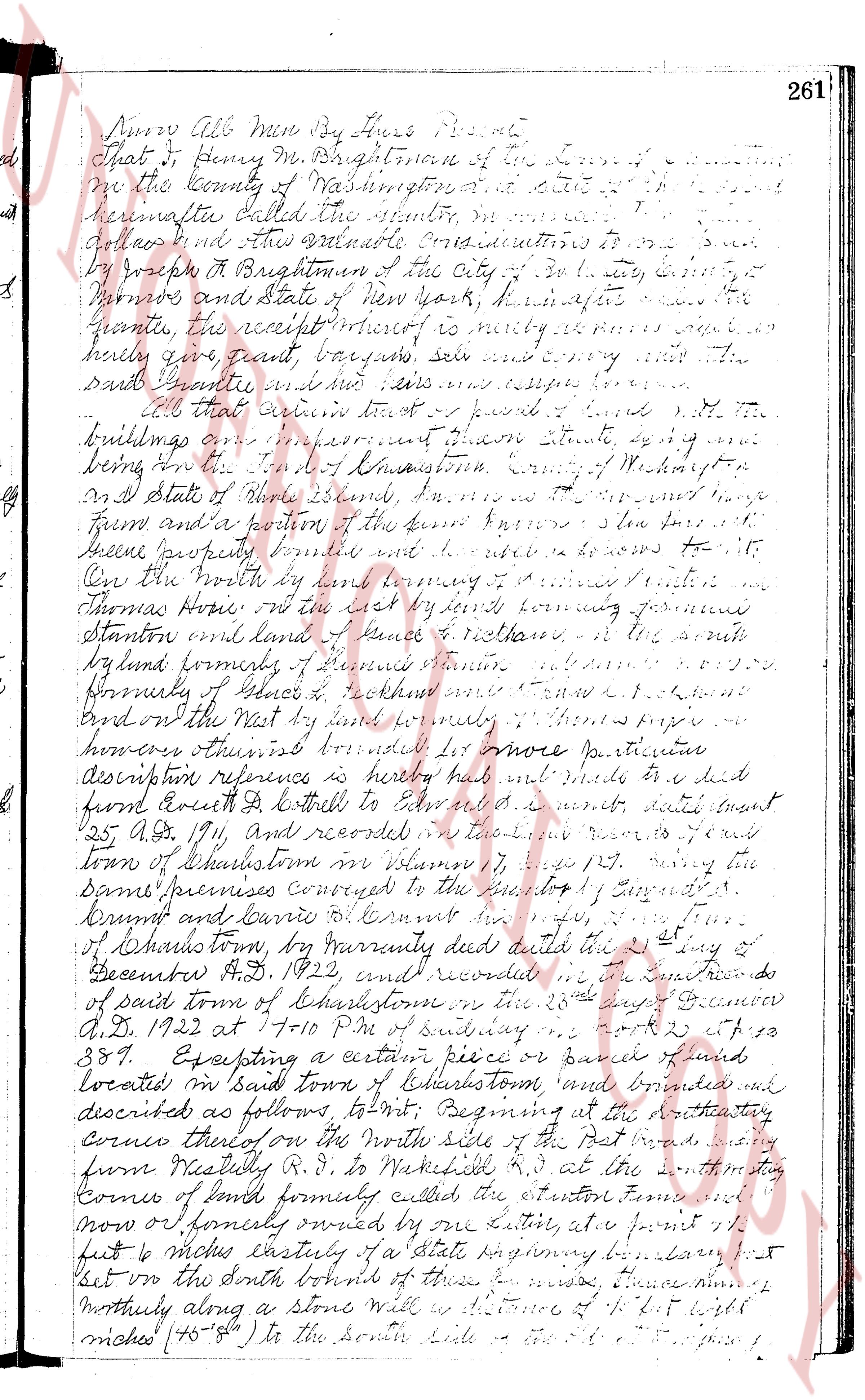
Anno All Men By These Presents
That I Henry M. Brightman of the Town of [blank]
in the County of Washington and State of [blank]
hereinafter called the grantor, in consideration
of [blank] and other valuable considerations to be
by Joseph A Brightman of the City of [blank] by [blank]
survivor and State of New York, hereinafter
called the grantee, receipt of which is hereby acknowledged
hereby give, grant, bargain, sell and convey unto the
said Grantee and his heirs and assigns forever
All that certain tract of land with all buildings
improvements thereon situated being one
being the Town of Narragansett Country of Washington
and State of Rhode Island in the said town known as the
farm and a portion of the farm known as the
green property bounded and described as follows to wit
On the North by land belonging to [blank] and [blank]
Thomas Horne On the East by land belonging to Samuel
Stanton and land of James R. Rollins on the South
by land belonging to Samuel Stanton and [blank]
formerly of James S. Rollins and [blank] R. Rollins
and on the West by land of newly [blank] Thomas Hope
his heirs and assigns bounded as follows more particular
description reference is hereby made to a deed
from Ezra D Bottell to Edward [blank] dated [blank]
25th Apr 1911, and recorded in the [blank] records of the
town of Charlestown on page 179 saying the
same premises conveyed to the [blank] L. [blank]
drums and [blank] E. [blank] dated the 2nd day of
December A.D. 1922, and recorded in the [blank] records
of said town of Charlestown on the 23rd day of December
A.D. 1922 at 1 to 10 P.M. of said booking vol 23 p 389
Excepting a certain piece or parcel of land
located in said town of Charlestown and bounded and
described as follows to wit Beginning at the southeasterly
corner thereof on the North side of the Post Road, running
from Narragansett R.I. to Wickford R.I. at the southeasterly
corner of land formerly called the station farm and
now of formerly owned by one Latimer, at a point 13
feet 6 inches easterly of a State highway boundary line
set over the south bound of these premises, running
northerly along a stone wall six distance of 4 feet wide
niches (76-8") to the South side of a [blank] [blank] [blank]
page 2
262
then westerly in a curve a distance of six hundred
eight feet N 18° W, more or less, following along
the center of the State highway to a point
where said highway and the First Road intersect
and thence S 14° E, 214 feet westward
to a point where it intersects with a way
and thence to a point where said way ends
and thence westerly by land now owned by
[illegible]
[illegible]
[illegible]
[illegible]
[illegible]
[illegible]
[illegible]
[illegible]
[illegible]
[illegible]
[illegible]
[illegible]
and recorded in the
Land Records of said town of Charlestown in Book 20,
at page 387, the said parcel of land having been purchased
from him the remainder of that conveyed to the said Henry M.
Brightman by Samuel A. Dunn as aforesaid, by the location
and construction of the said New State Highway called
the First Road running west Westerly to Wakefield
said piece of land being conveyed by the said Henry M.
Brightman to James H. Brightman and Alice M. Brightman
of the same city deceased november 28, 1927 in Book
13, page 115 of the Land Records of said town of Charlestown
Save Excepting a certain tract or parcel of land situated
in said town known only and named and described as follows
to wit Beginning at the intersection of the First Road and
the West Narragansett Beach Road southerly and thening
easterly along Beach Road about 1988 feet more or less
to a stone wall fence running easterly along stone wall to a
point bounding easterly by lands of William O. Lattin
and thening roughly angle a stone wall to the first bounding
westerly by lands of the said Lattin thence westerly bounding
northerly by edge of said First Road to the place of beginning as
above described being a portion of the farm
deeded to Henry M. Brightman by Edward S. Dunn by deed
dated December 21, 1922 and on Record in Land Records
town of Charlestown in Book 20, page 389
said piece of land being conveyed by Henry M. Brightman
to Charles A. Brightman by deed recorded October 23, 1928 in
Book 26, page 387 of the Land Records of said town of Charlestown
and used the following approved premises lying and being
in said town of Charlestown, being a portion of the farm
above particularly referred to:
Commencing at the northeasterly corner of said land where
page 3
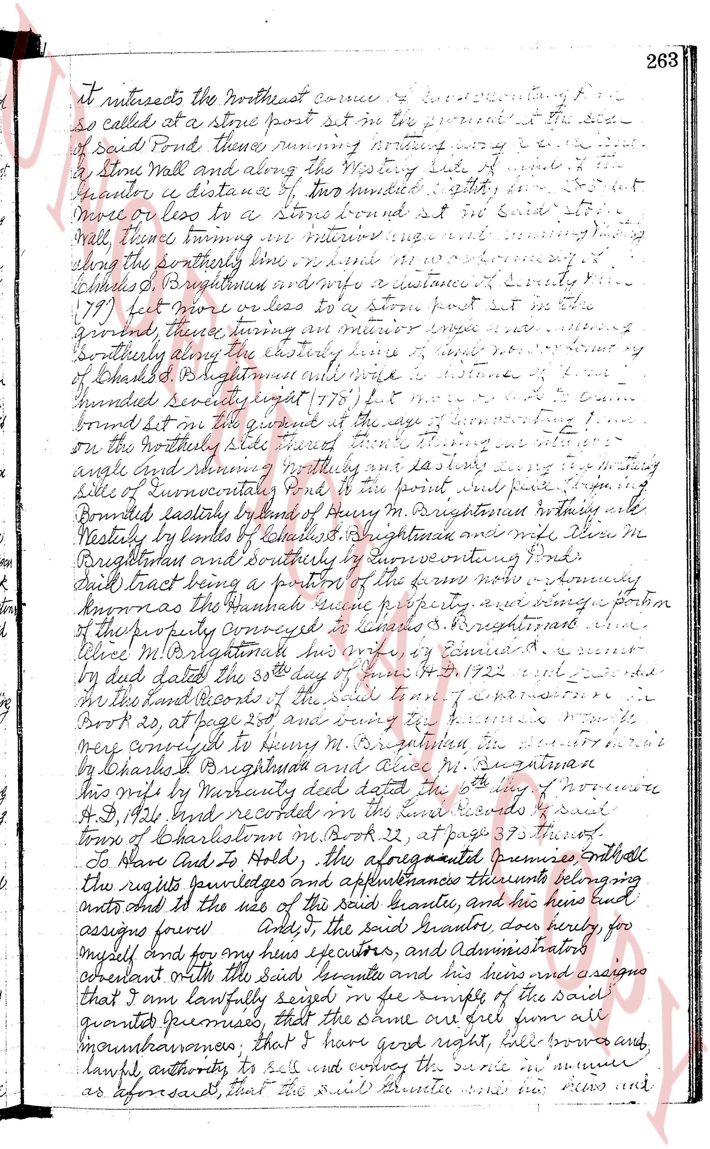
It intersects the northeast corner of the connecting
so called at a stone post set in the ground in the side
of said Pond thence running northerly vary[ing] courses
to a Stone Wall and along the westerly side of said wall
to the corner a distance of two hundred & eighty six feet
more or less to a Stone bound set in said stone
Wall thence turning an interior angle and running
along the southerly line more or less one hundred fifty
(150) feet Brightman marks a distance of Seventy five
(75) feet more or less to a stone post set in the
ground, thence turning an interior angle and running
southerly along the easterly line of a certain piece of
land bought by Brightman from his wife a distance of
two hundred seventy eight (278) feet & more or less
bound set in the same ground at the edge of connecting land
on the northerly side thereof then turning an interior
angle and running northerly and easterly along the westerly
side of Cunvarter's lot to the point first described beginning
Bounded easterly by land of Henry M. Brightman in northing and
Westerly by lands of Charles T. Brightman and his wife Mrs
Brightman and southerly by Cunvarter's connecting Pond.
said tract being a portion of the farm now a tenancy
known as the Hannah Quick property and being a portion
of the property conveyed to Charles T. Brightman and
his wife M. Brightman by deed by Edward A. [?]
by deed dated the 30th day of June A.D. 1722 entered
in the Land Records of the said town in volume
Book 20, at page 203 and being part of the farm
mere conveyed to Henry M. Brightman by deed
by Charles T. Brightman and his wife M. Brightman
by Warranty deed dated the 6th day of November
A.D. 1921 recorded in the land records of said
town of Charlestown in Book 32, at page 395 thereof.
To Have And To Hold, the aforesaid premises with
the rights privileges and appurtenances thereunto belonging
unto and to the use of the said Grantee and his heirs and
assigns forever And I the said Grantor does hereby for
myself and for my heirs executors, and Administrators
covenant with the said Grantee and his heirs and assigns
that I am lawfully seized in the simple of the said
granted premises that the same are free from all
incumbrances; that I have good right full power and
lawful authority to sell and convey the same in manner
as aforesaid that the said Grantee and his heirs and assigns
page 4
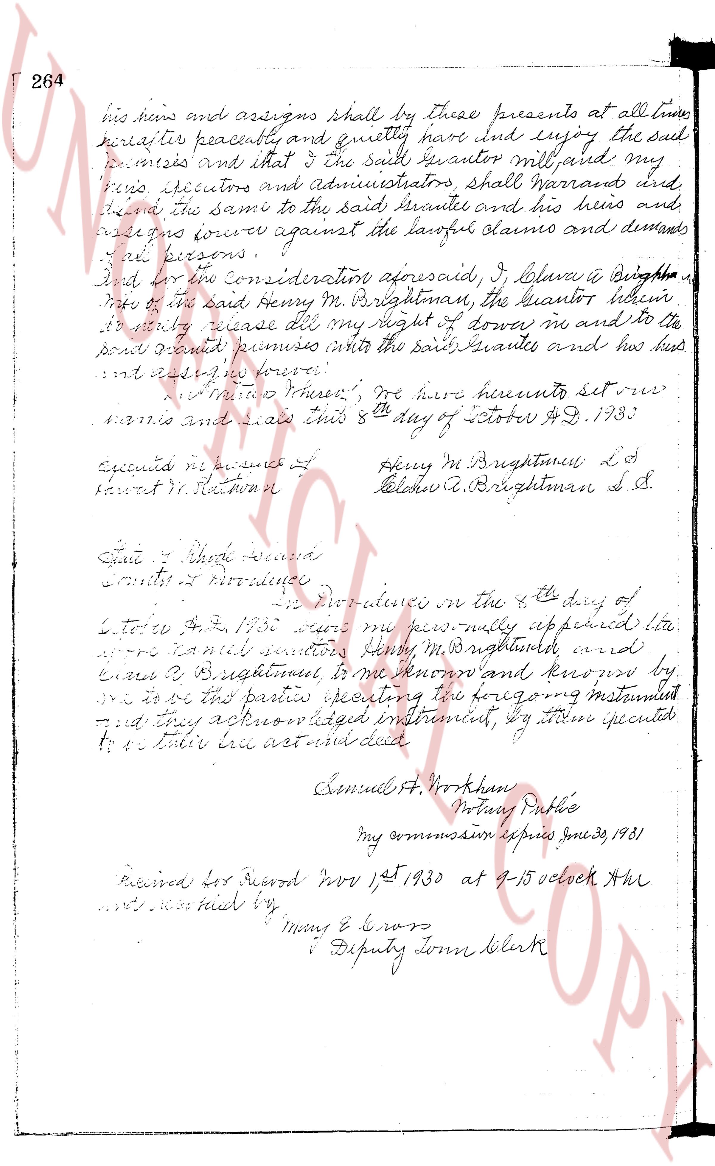
264 his heirs and assigns shall by these presents at all times
hereafter peacefully and quietly have and enjoy the said
premises and that I the said grantor will, and my
heirs executors and administrators, shall warrant and
defend the same to the said grantee and his heirs and
assigns against the lawful claims and demands
of all persons.
And for the consideration aforesaid, I Letitia B. Brightman
wife of the said Henry M. Brightman, the grantor hereby
do hereby release all my right of dower in and to the
said granted premises unto the said grantee and his heirs
and assigns forever.
In witness whereof, we have hereunto set our
names and seals this 8th day of October A.D. 1930.
executed before me
Samuel H. Workman Henry M. Brightman L.S.
Letitia B. Brightman L.S.
State of Rhode Island
County of Providence
On Providence in the 8th day of
October A.D. 1930 were personally appeared before
me Samuel Workman Henry M. Brightman and
Letitia B. Brightman, to me known and known by
me to be the parties executing the foregoing instrument
and they acknowledged instrument, by their signatures
to be their act and deed
Samuel H. Workman
Notary Public
my commission expires June 30, 1931
Received for Record Nov 1st 1930 at 9-15 o'clock A.M.
recorded by
Mary E. Cross
Deputy Town Clerk
The page as recorded