The instrument's own words
page 1 · read by Gemma vision
691
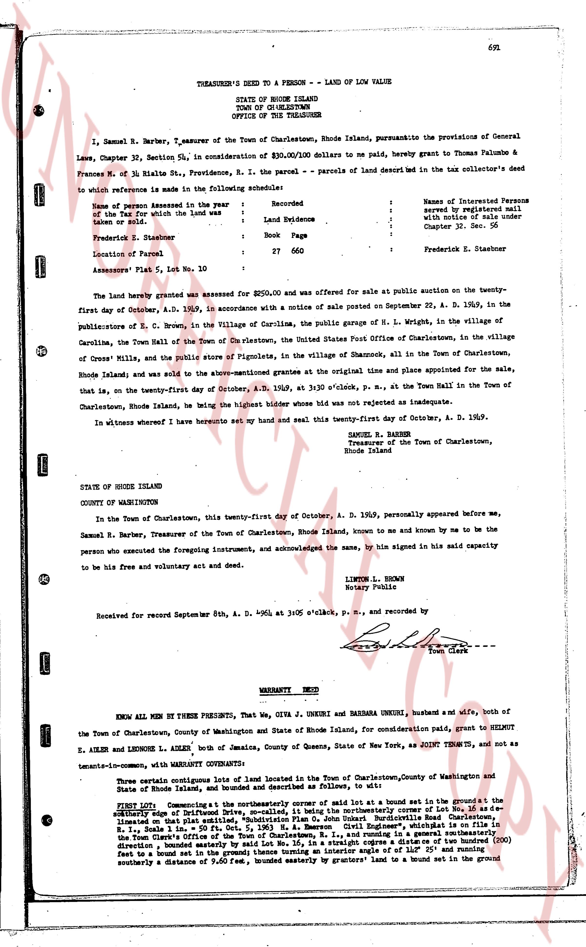
TREASURER'S DEED TO A PERSON - LAND OF LOW VALUE
STATE OF RHODE ISLAND
TOWN OF CHARLESTOWN
OFFICE OF THE TREASURER
I, Samuel R. Barber, Treasurer of the Town of Charlestown, Rhode Island, pursuantko the provisions of General
Laws, Chapter 32, Section 34, in consideration of $30.00/100 dollars to me paid, hereby grant to Thomas Palumbo &
Frances M. of Nr. Rials St., Providence, R. I. the parcel - parcels of land described in the tax collector's deed
to which reference is made in the following schedule:
Name of person Assessed in the year : Recorded
of the Tax for which the land was : Land Evidence
taken of him:
: Book Page
Frederick E. Staebner : 27 660
Location of Parcel :
Assessors' Plat 5, Lot No. 10 : Frederick E. Staebner
The land hereby granted was assessed for $250.00 and was offered for sale at public auction on the twenty-
first day of October, A. D. 1969, in accordance with a notice of sale posted on September 22, A. D. 1969, in the
publications of E. C. Brown, in the Village of Carolina, the public garage of H. L. Wright, in the village of
Carolina, the Town Hall of the Town of Charlestown, the United States Post Office of Charlestown, in the village
of Cross Mills, and the public store of Pignolata, in the village of Shannock, all in the Town of Charlestown,
Rhode Island; and was sold to the above-mentioned grantees at the original time and place appointed for the sale,
that is, on the twenty-first day of October, A. D. 1969, at 3:00 o'clock, p. m., at the Town Hall in the Town of
Charlestown, Rhode Island, he being the highest bidder whose bid was not rejected as inadequate.
In witness whereof I have hereunto set my hand and seal this twenty-first day of October, A. D. 1969.
SAMUEL R. BARBER
Treasurer of the Town of Charlestown,
Rhode Island
STATE OF RHODE ISLAND
COUNTY OF WASHINGTON
In the Town of Charlestown, this twenty-first day of October, A. D. 1969, personally appeared before me,
Samuel R. Barber, Treasurer of the Town of Charlestown, Rhode Island, known to me and known by me to be the
person who executed the foregoing instrument, and acknowledged the same, by him signed in his said capacity
to be his free and voluntary act and deed.
LINTON L. BROWN
Notary Public
Received for record September 8th, A. D. 1964 at 3:05 o'clock, p. m., and recorded by
[Signature]
Town Clerk
----
WARRANTY DEED
KNOW ALL MEN BY THESE PRESENTS, That, We, OIVA J. UNKURI and BARBARA UNKURI, husband and wife, both of
the Town of Charlestown, County of Washington and State of Rhode Island, for consideration paid, grant to HELMUT E.
ADLER and LEONORE L. ADLER, both of Jamaica, County of Queens, State of New York, as JOINT TENANTS, and not as
tenants-in-common, with WARRANTY COVENANTS:
That certain contiguous lots of land located in the Town of Charlestown, County of Washington and State
of Rhode Island, and bounded and described as follows, to wit:
FIRST LOT, Commencing at the northeasterly corner of said lot in a bound set in the ground; t he
southerly edge of said lot runs by a straight line to a bound set in the southeasterly corner of Lot No. 16 as de-
scribed on that plat entitled, "Subdivision Plan O. John Unkuri Burdicoville Road Charlestown" recorded in the
Town of Charlestown, R. I., Scale 1" = 100', in the Office of the Town Clerk, recorded in Book 215, Page 11 in the
Town Clerk's Office of the Town of Charlestown, R. I., and running in a general southeasterly
direction, bounded easterly by said Lot No. 16, in a straight line to a bound set in the southeasterly corner (200)
direction, bounded easterly by said Lot No. 16, in a straight line to a bound set in the southeasterly corner (200)
direction, bounded easterly by said Lot No. 16, in a straight line to a bound set in the southeasterly corner (200)
direction, bounded easterly by said Lot No. 16, in a straight line to a bound set in the southeasterly corner (200)
direction, bounded easterly by said Lot No. 16, in a straight line to a bound set in the southeasterly corner (200)
direction, bounded easterly by said Lot No. 16, in a straight line to a bound set in the southeasterly corner (200)
direction, bounded easterly by said Lot No. 16, in a straight line to a bound set in the southeasterly corner (200)
direction, bounded easterly by said Lot No. 16, in a straight line to a bound set in the southeasterly corner (200)
direction, bounded easterly by said Lot No. 16, in a straight line to a bound set in the southeasterly corner (200)
direction, bounded easterly by said Lot No. 16, in a straight line to a bound set in the southeasterly corner (200)
direction, bounded easterly by said Lot No. 16, in a straight line to a bound set in the southeasterly corner (200)
direction, bounded easterly by said Lot No. 16, in a straight line to a bound set in the southeasterly corner (200)
direction, bounded easterly by said Lot No. 16, in a straight line to a bound set in the southeasterly corner (200)
direction, bounded easterly by said Lot No. 16, in a straight line to a bound set in the southeasterly corner (200)
direction, bounded easterly by said Lot No. 16, in a straight line to a bound set in the southeasterly corner (200)
direction, bounded easterly by said Lot No. 16, in a straight line to a bound set in the southeasterly corner (200)
direction, bounded easterly by said Lot No. 16, in a straight line to a bound set in the southeasterly corner (200)
direction, bounded easterly by said Lot No. 16, in a straight line to a bound set in the southeasterly corner (200)
direction, bounded easterly by said Lot No. 16, in a straight line to a bound set in the southeasterly corner (200)
direction, bounded easterly by said Lot No. 16, in a straight line to a bound set in the southeasterly corner (200)
direction, bounded easterly by said Lot No. 16, in a straight line to a bound set in the southeasterly corner (200)
direction, bounded easterly by said Lot No. 16, in a straight line to a bound set in the southeasterly corner (200)
direction, bounded easterly by said Lot No. 16, in a straight line to a bound set in the southeasterly corner (200)
direction, bounded easterly by said Lot No. 16, in a straight line to a bound set in the southeasterly corner (200)
direction, bounded easterly by said Lot No. 16, in a straight line to a bound set in the southeasterly corner (200)
direction, bounded easterly by said Lot No. 16, in a straight line to a bound set in the southeasterly corner (200)
direction, bounded easterly by said Lot No. 16, in a straight line to a bound set in the southeasterly corner (200)
direction, bounded easterly by said Lot No. 16, in a straight line to a bound set in the southeasterly corner (200)
direction, bounded easterly by said Lot No. 16, in a straight line to a bound set in the southeasterly corner (200)
direction, bounded easterly by said Lot No. 16, in a straight line to a bound set in the southeasterly corner (200)
direction, bounded easterly by said Lot No. 16, in a straight line to a bound set in the southeasterly corner (200)
direction, bounded easterly by said Lot No. 16, in a straight line to a bound set in the southeasterly corner (200)
direction, bounded easterly by said Lot No. 16, in a straight line to a bound set in the southeasterly corner (200)
direction, bounded easterly by said Lot No. 16, in a straight line to a bound set in the southeasterly corner (200)
direction, bounded easterly by said Lot No. 16, in a straight line to a bound set in the southeasterly corner (200)
direction, bounded easterly by said Lot No. 16, in a straight line to a bound set in the southeasterly corner (200)
direction, bounded easterly by said Lot No. 16, in a straight line to a bound set in the southeasterly corner (200)
direction, bounded easterly by said Lot No. 16, in a straight line to a bound set in the southeasterly corner (200)
direction, bounded easterly by said Lot No. 16, in a straight line to a bound set in the southeasterly corner (200)
direction, bounded easterly by said Lot No. 16, in a straight line to a bound set in the southeasterly corner (200)
direction, bounded easterly by said Lot No. 16, in a straight line to a bound set in the southeasterly corner (200)
direction, bounded easterly by said Lot No. 16, in a straight line to a bound set in the southeasterly corner (200)
direction, bounded easterly by said Lot No. 16, in a straight line to a bound set in the southeasterly corner (200)
direction, bounded easterly by said Lot No. 16, in a straight line to a bound set in the southeasterly corner (200)
direction, bounded easterly by said Lot No. 16, in a straight line to a bound set in the southeasterly corner (200)
direction, bounded easterly by said Lot No. 16, in a straight line to a bound set in the southeasterly corner (200)
direction, bounded easterly by said Lot No. 16, in a straight line to a bound set in the southeasterly corner (200)
direction, bounded easterly by said Lot No. 16, in a straight line to a bound set in the southeasterly corner (200)
direction, bounded easterly by said Lot No. 16, in a straight line to a bound set in the southeasterly corner (200)
direction, bounded easterly by said Lot No. 16, in a straight line to a bound set in the southeasterly corner (200)
direction, bounded easterly by said Lot No. 16, in a straight line to a bound set in the southeasterly corner (200)
direction, bounded easterly by said Lot No. 16, in a straight line to a bound set in the southeasterly corner (200)
direction, bounded easterly by said Lot No. 16, in a straight line to a bound set in the southeasterly corner (200)
direction, bounded easterly by said Lot No. 16, in a straight line to a bound set in the southeasterly corner (200)
direction, bounded easterly by said Lot No. 16, in a straight line to a bound set in the southeasterly corner (200)
direction, bounded easterly by said Lot No. 16, in a straight line to a bound set in the southeasterly corner (200)
direction, bounded easterly by said Lot No. 16, in a straight line to a bound set in the southeasterly corner (200)
direction, bounded easterly by said Lot No. 16, in a straight line to a bound set in the southeasterly corner (200
page 2 · read by Gemma vision
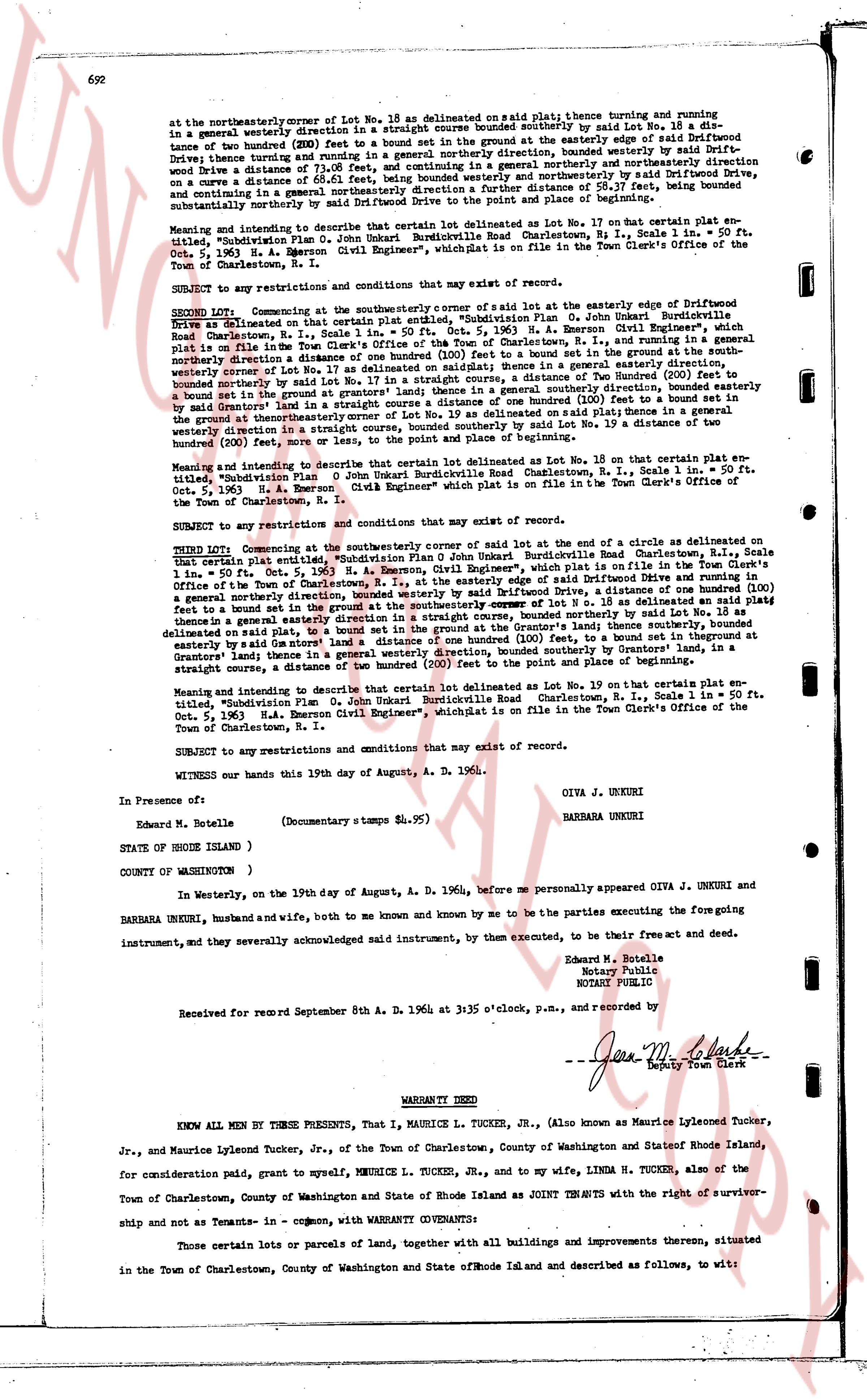
at the northeasterly corner of Lot No. 18 as delineated on said plat; thence turning and running in a general westerly direction in a straight course bounded southerly by said Lot No. 18 a distance of two hundred (200) FEET to a bound set in the ground; thence turning and running in a general northwest direction in a straight course bounded southerly by said Driftwood Drive a distance of 71.08 FEET, and continuing in a general northerly and northwesterly direction on a curve a distance of 55.17 FEET, and continuing in a general northerly direction a further distance of 58.17 FEET, being bounded generally in a general northerly direction by the Drive to the point and place of beginning.
Meaning and intending to describe that certain lot of land delineated as Lot No. 17 on that certain plat entitled, "Subdivision Plan O. Junkari Burkdurdville Road Charlestown, R.I., Scale 1 in. = 50 ft. Oct. 5, 1963, H. A. Emerson Civil Engineer", which plat is on file in the Town Clerk's Office of the Town of Charlestown, R.I.
SUBJECT to any restrictions and conditions that may exist of record.
SECOND Lot. Commencing at the southeasterly corner of said lot at the easterly edge of Driftwood Drive as delineated on that certain plat entitled, "Subdivision Plan O. Junkari Burkdurdville Road Charlestown, R.I., Scale 1 in. = 50 ft. Oct. 5, 1963, H. A. Emerson Civil Engineer", which plat is on file in the Town Clerk's Office of the Town of Charlestown, R.I., and running in a general northerly direction a distance of 110 FEET to a bound set in the ground; thence in a general easterly direction, westerly curved as shown on lot No. 17 as delineated on said plat; thence in a general easterly direction, bounded northerly by said Lot No. 17 as delineated on said plat, 110 FEET to a bound set in the ground; bounded northerly by the land of the said grantors' lands; thence in a general southerly direction, bounded easterly by said grantors' land in a straight course a distance of 200 FEET to a bound set in the ground; bounded northerly on Lot No. 19 as delineated on said plat; thence in a general westerly direction in a straight course, bounded southerly by said Lot No. 19 a distance of two hundred (200) FEET to the point and place of beginning.
Meaning and intending to describe that certain lot delineated as Lot No. 18 on that certain plat entitled, "Subdivision Plan O. Junkari Burkdurdville Road Charlestown, R.I., Scale 1 in. = 50 ft. Oct. 5, 1963, H. A. Emerson Civil Engineer" which plat is on file in the Town Clerk's Office of the Town of Charlestown, R.I.
SUBJECT to any restrictions and conditions that may exist of record.
THIRD Lot. Commencing at the southeasterly corner of said lot of the end of a circle as delineated on said certain plat entitled, "Subdivision Plan O. Junkari Burkdurdville Road Charlestown, R.I., Scale 1 in. = 50 ft. Oct. 5, 1963, H. A. Emerson Civil Engineer", which plat is on file in the Town Clerk's Office of the Town of Charlestown, R.I., at the easterly edge of Driftwood Drive, a distance of one hundred (100) FEET, a general northerly direction starting at the easterly edge of Driftwood Drive, a distance of 110 FEET to a bound set in the ground at the southeasterly corner of lot No. 18 as delineated on said plat; thence in a general easterly direction, bounded northerly by said Lot No. 18 as delineated on said plat, to a bound set in the ground at the Grantors' land thence southerly as delineated on said plat, to a bound set in the ground at the Grantors' land; thence in a general westerly direction, bounded southerly by Grantors' land, in a straight course, a distance of 200 FEET to the point and place of beginning.
Meaning and intending to describe that certain lot delineated as Lot No. 19 on that certain plat entitled, "Subdivision Plan O. Junkari Burkdurdville Road Charlestown, R.I., Scale 1 in. = 50 ft. Oct. 5, 1963, H. A. Emerson Civil Engineer", which plat is on file in the Town Clerk's Office of the Town of Charlestown, R.I.
SUBJECT to any restrictions and conditions that may exist of record.
WITNESS our hands this 19th day of August, A. D. 1964.
OIVA J. UNKURI
BARBARA UNKURI
In Presence of:
Edward M. Botelle
(Documentary stamps a $4.95)
STATE OF RHODE ISLAND )
COUNTY OF WASHINGTON )
In Westerly, on the 19th day of August, A. D. 1964, before me personally appeared OIVA J. UNKURI and BARBARA UNKURI, husband and wife, both to me known and by me known by me to be the parties executing the foregoing instrument, and they severally acknowledged said instrument, by them executed, to be their free act and deed.
Edward M. Botelle
Notary Public
NOTARY PUBLIC
Received for record September 8th A. D. 1964 at 3:35 o'clock p.m., and recorded by
[Signature]
Deputy Town Clerk
----
WARRANTY DEED
KNOW ALL MEN BY THESE PRESENTS, That I, MAURICE L. TUCKER, Jr., (Also known as Maurice Lyleone Tucker, Jr., and Maurice Lyleone Tucker, Jr., of the Town of Charlestown, County of Washington and State of Rhode Island, for consideration paid, grant to myself, MAURICE L. TUCKER, Jr., and to my wife, LINDA H. TUCKER, also of the Town of Charlestown, County of Washington and State of Rhode Island as JOINT TENANTS with the right of survivorship and not as Tenants-in-common, with WARRANTY COVENANTS:
Those certain lots or parcels of land, together with all buildings and improvements thereon, situated in the Town of Charlestown, County of Washington and State of Rhode Island and described as follows, to wit:
The page as recorded