The instrument's own words
page 1 · read by Gemma vision
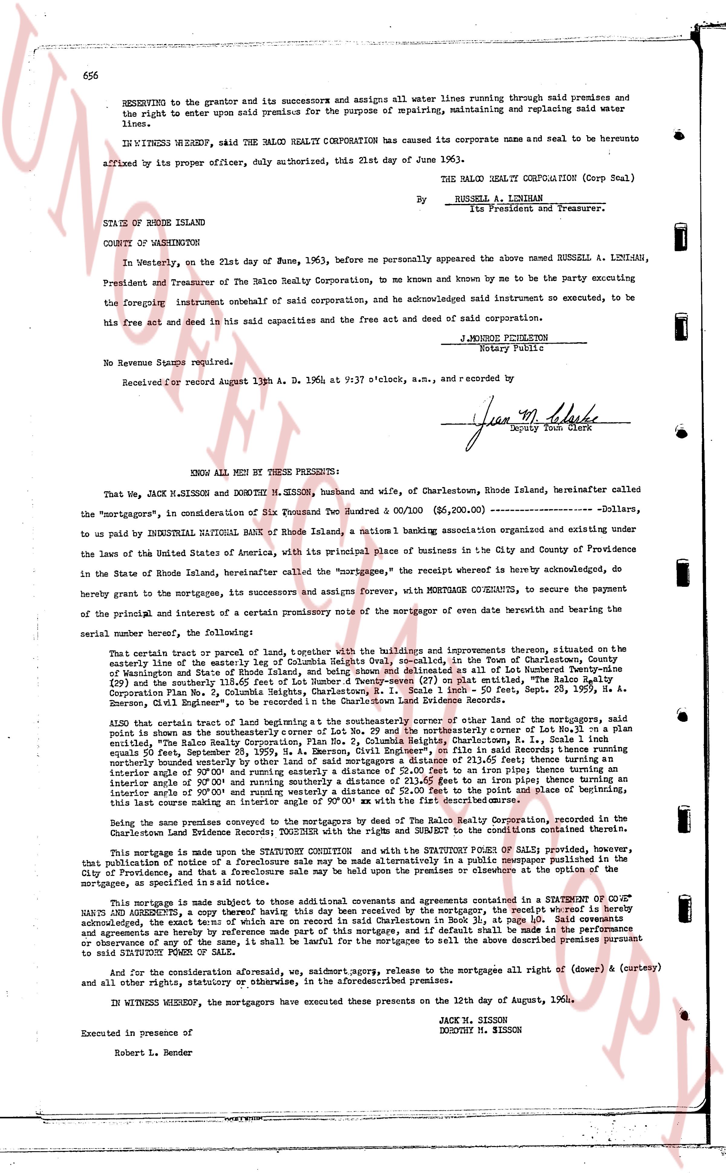
656
RESERVING to the grantor and its successors and assigns all water lines running through said premises and the right to enter upon said premise for the purpose of repairing, maintaining and replacing said water lines.
IN WITNESS WHEREOF, said THE SALGO REALTY CORPORATION has caused its corporate name and seal to be hereunto affixed by its proper officer, duly authorized, this 21st day of June 1963).
THE SALGO REALTY CORPORATION (Corp Seal)
By RUSSELL A. LINTHIAN
Its President and Treasurer.
STATE OF RHODE ISLAND
COUNTY OF WASHINGTON
In Westerly, on the 21st day of June, 1963, before me personally appeared the above named RUSSELL A. LINTHIAN, President and Treasurer of The Salgo Realty Corporation, to me known and by me to be the party executing the foregoing instrument onbehalf of said corporation, and he acknowledged said instrument so executed, to be his free act and deed and in said capacities and the free act and deed of said corporation.
J. MONROE PHILLIPS
Notary Public
No Revenue Stamps required.
Received for record August 13th A. D. 1964 at 9:37 o'clock, a.m., and recorded by
[Signature]
Deputy Town Clerk
----
KNOW ALL MEN BY THESE PRESENTS:
That We, JACK M. SISSON and DOROTHY M. SISSON, husband and wife, of Charlestown, Rhode Island, hereinafter called the "mortgagors", in consideration of Six Thousand Two Hundred & 00/100 ($6,200.00) —————— Dollars, to us paid by INDUSTRIAL NATIONAL BANK OF RHODE ISLAND, a national 1 banking association organizing and existing under the laws of the United States of America, with its principal place of business in the City and County of Providence in the State of Rhode Island, hereinafter called the "mortgagee", the receipt whereof is hereby acknowledged, do hereby grant to the mortgagees, its successors and assigns forever, WITH MORTGAGE COVENANTS, to secure the payment of the principal, and of interest and a certain promissory note of the mortgagor of an even date herewith and bearing the said memorial number, the following:
That certain parcel or tract of land, together with the buildings and improvements thereon, situated on the easterly line of the easterly leg of Columbia Heights oval, described in the Town of Charlestown, County of Washington and State of Rhode Island as follows: Beginning at a point on the easterly line of Lot Number 29 (Plat 109) and thence southerly one 118.65 feet of Lot Number Twenty-seven (27) on said plat, entitled "The Salgo Realty Corporation Plat No. 2, Columbia Heights, Charlestown, R.I." as recorded June 20, Sept. 28, 1959, R. A. Emerson, Civil Engineer's, in the Charlestown Land Evidence Records.
ALSO that certain tract of land beginning at the southeasterly corner of either one of the lot boundaries, said point is known as the southeasterly corner of Lot No. 29 and the northeasterly corner of Lot No. 27 in a plan entitled "The Salgo Realty Corporation Plat No. 2, Columbia Heights, Charlestown, R.I." as recorded June 20, Sept. 28, 1959, R. A. Emerson, Civil Engineer's, on file in said Records; thence running southeasterly 50.00 feet on the boundary line of Lot No. 27; thence running northeasterly 50.00 feet to a point forming an interior angle of 90.00 degrees and running easterly a distance of 52.00 feet to an intersection of prime lines; thence running northeasterly 50.00 feet to a point forming an interior angle of 90.00 degrees and running on an imp line running northwesterly an interior angle of 90.00 degrees and running westerly a distance of 52.00 feet to the point and place of beginning, this last course making an interior angle of 90.00 degrees with the xy [?] of the boundaries.
Being the same premises conveyed to the mortgagors by The Salgo Realty Corporation, recorded in the Charlestown Land Evidence Records; TOGETHER with the right and REMEDY to the benefits and conditions therein contained.
This mortgage is made upon the STATUTORY CONDITION and with the STATUTORY POWERS OF SALE; provided, however, that publication of notice of a foreclosure sale may be made alternatively in a public newspaper published in the city of Providence, and that a failure to publish in any one newspaper or otherwise act in accordance with the statutory mortgage, as specified in said notice.
This mortgage is made subject to above mentioned additional covenants and agreements contained in a STATEMENT OF CONDITIONS, said statement, a copy of which having this day been received by the mortgagor, the receipt whereof is hereby acknowledged, the exact terms of which are on record in said Charlestown in Book 38, at page 10. Said covenants and agreements are hereby incorporated into this mortgage and shall be deemed to be a part hereof as if fully set forth or observance of any of the same, it shall be lawful for the mortgagees to sell the above described premises pursuant to said STATUTORY POWERS OF SALE.
And for the consideration aforesaid, we, saldmortgors, agree, release to the mortgagee all right of (dower & curtesy) and all other rights, statutory or otherwise, in the aforementioned premises.
IN WITNESS WHEREOF, the mortgagors have executed these presents on the 12th day of August, 1964.
JACK M. SISSON
DOROTHY M. SISSON
Executed in presence of
Robert L. Bender
page 2 · read by Gemma vision
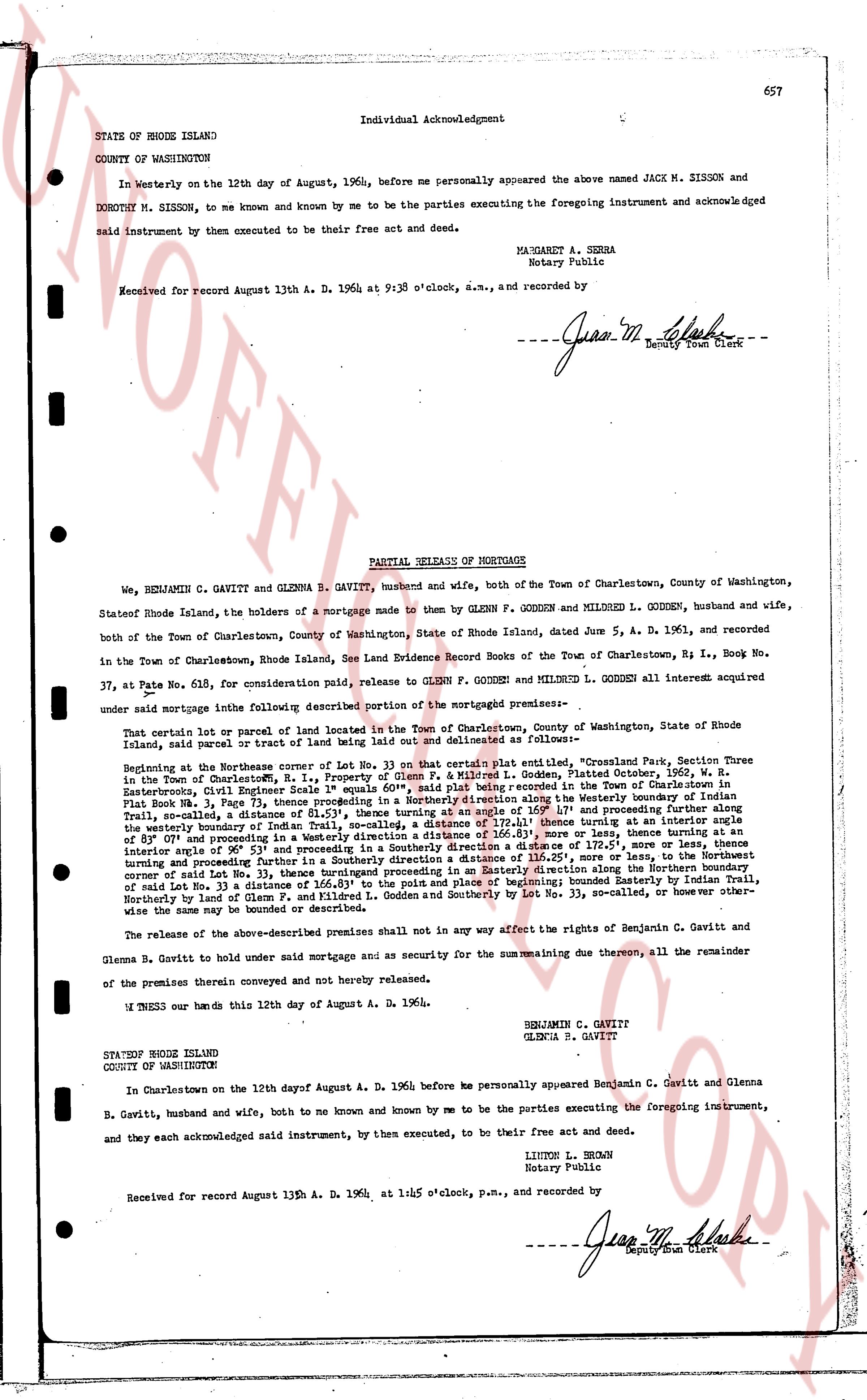
657
Individual Acknowledgment
STATE OF RHODE ISLAND
COUNTY OF WASHINGTON
In witnessy on the 12th day of August, 1964, before me personally appeared the above named JACK M. SISSON and DOROTHY M. SISSON, to me known and known by me to be the parties executing the foregoing instrument and acknowledged said instrument by them executed to be their free act and deed.
MARGARET A. SEHRA
Notary Public
Received for record August 13th A. D. 1964 at 9:38 o'clock, a.m., and recorded by
[Signature]
Deputy Town Clerk
----
PARTIAL RELEASE OF MORTGAGE
We, BENJAMIN C. GAVITT & GLENNA B. GAVITT, husband and wife, both of the Town of Charlestown, County of Washington, Stateof Rhode Island, the holders of a mortgage made to them by GLENN F. GODDEN and MILRED L. GODDEN, husband and wife, both of the Town of Charlestown, County of Washington, State of Rhode Island, dated June 5, A. D. 1961, and recorded in the Town of Charlestown, Rhode Island, See Land Evidence Record Books of the Town of Charlestown, Es I., Book No. 37, at Page 615, for consideration paid, release to GLENN F. GODDEN and MILRED L. GODDEN all other interest acquired under said mortgage into the following described portion of the mortgaged premises--
That certain plot or parcel of land located in the Town of Charlestown, County of Washington, State of Rhode Island, said parcel or tract of land being out laid and delineated as follows--
Beginning at the Northwest corner of Lot No. 33 on that certain plat entitled the "Quassapaug Section Three in the Town of Charlestown, RI", said plat being recorded in the Town of Charlestown, Dated October, 1962, W. R. Easterbrooks, Civil Engineer Scale 1" equals 60', said plat being recorded in the Town of Charlestown, Flat Book No. 3, Page 73, said Northwest corner of Lot No. 33 being on the westerly boundary of Indian Trail, said boundary, a distance of 61.51', thence turning at an angle of 160° 1' and proceeding further along said westerly boundary of Indian Trail, a distance of 111.11', thence turning at an angle of 180° turning at an angle of 180° along the westerly boundary of Indian Trail, a distance of 61.51', thence turning at an angle of 160° 1' and proceeding further along said westerly boundary of Indian Trail, a distance of 111.11', thence turning at an angle of 180° turning at an angle of 180° along the westerly boundary of Indian Trail, a distance of 61.51', thence turning at an angle of 160° 1' and proceeding further along said westerly boundary of Indian Trail, a distance of 111.11', thence turning at an angle of 180° turning at an angle of 180° along the westerly boundary of Indian Trail, a distance of 61.51', thence turning at an angle of 160° 1' and proceeding further along said westerly boundary of Indian Trail, a distance of 111.11', thence turning at an angle of 180° turning at an angle of 180° along the westerly boundary of Indian Trail, a distance of 61.51', thence turning at an angle of 160° 1' and proceeding further along said westerly boundary of Indian Trail, a distance of 111.11', thence turning at an angle of 180° turning at an angle of 180° along the westerly boundary of Indian Trail, a distance of 61.51', thence turning at an angle of 160° 1' and proceeding further along said westerly boundary of Indian Trail, a distance of 111.11', thence turning at an angle of 180° turning at an angle of 180° along the westerly boundary of Indian Trail, a distance of 61.51', thence turning at an angle of 160° 1' and proceeding further along said westerly boundary of Indian Trail, a distance of 111.11', thence turning at an angle of 180° turning at an angle of 180° along the westerly boundary of Indian Trail, a distance of 61.51', thence turning at an angle of 160° 1' and proceeding further along said westerly boundary of Indian Trail, a distance of 111.11', thence turning at an angle of 180° turning at an angle of 180° along the westerly boundary of Indian Trail, a distance of 61.51', thence turning at an angle of 160° 1' and proceeding further along said westerly boundary of Indian Trail, a distance of 111.11', thence turning at an angle of 180° turning at an angle of 180° along the westerly boundary of Indian Trail, a distance of 61.51', thence turning at an angle of 160° 1' and proceeding further along said westerly boundary of Indian Trail, a distance of 111.11', thence turning at an angle of 180° turning at an angle of 180° along the westerly boundary of Indian Trail, a distance of 61.51', thence turning at an angle of 160° 1' and proceeding further along said westerly boundary of Indian Trail, a distance of 111.11', thence turning at an angle of 180° turning at an angle of 180° along the westerly boundary of Indian Trail, a distance of 61.51', thence turning at an angle of 160° 1' and proceeding further along said westerly boundary of Indian Trail, a distance of 111.11', thence turning at an angle of 180° turning at an angle of 180° along the westerly boundary of Indian Trail, a distance of 61.51', thence turning at an angle of 160° 1' and proceeding further along said westerly boundary of Indian Trail, a distance of 111.11', thence turning at an angle of 180° turning at an angle of 180° along the westerly boundary of Indian Trail, a distance of 61.51', thence turning at an angle of 160° 1' and proceeding further along said westerly boundary of Indian Trail, a distance of 111.11', thence turning at an angle of 180° turning at an angle of 180° along the westerly boundary of Indian Trail, a distance of 61.51', thence turning at an angle of 160° 1' and proceeding further along said westerly boundary of Indian Trail, a distance of 111.11', thence turning at an angle of 180° turning at an angle of 180° along the westerly boundary of Indian Trail, a distance of 61.51', thence turning at an angle of 160° 1' and proceeding further along said westerly boundary of Indian Trail, a distance of 111.11', thence turning at an angle of 180° turning at an angle of 180° along the westerly boundary of Indian Trail, a distance of 61.51', thence turning at an angle of 160° 1' and proceeding further along said westerly boundary of Indian Trail, a distance of 111.11', thence turning at an angle of 180° turning at an angle of 180° along the westerly boundary of Indian Trail, a distance of 61.51', thence turning at an angle of 160° 1' and proceeding further along said westerly boundary of Indian Trail, a distance of 111.11', thence turning at an angle of 180° turning at an angle of 180° along the westerly boundary of Indian Trail, a distance of 61.51', thence turning at an angle of 160° 1' and proceeding further along said westerly boundary of Indian Trail, a distance of 111.11', thence turning at an angle of 180° turning at an angle of 180° along the westerly boundary of Indian Trail, a distance of 61.51', thence turning at an angle of 160° 1' and proceeding further along said westerly boundary of Indian Trail, a distance of 111.11', thence turning at an angle of 180° turning at an angle of 180° along the westerly boundary of Indian Trail, a distance of 61.51', thence turning at an angle of 160° 1' and proceeding further along said westerly boundary of Indian Trail, a distance of 111.11', thence turning at an angle of 180° turning at an angle of 180° along the westerly boundary of Indian Trail, a distance of 61.51', thence turning at an angle of 160° 1' and proceeding further along said westerly boundary of Indian Trail, a distance of 111.11', thence turning at an angle of 180° turning at an angle of 180° along the westerly boundary of Indian Trail, a distance of 61.51', thence turning at an angle of 160° 1' and proceeding further along said westerly boundary of Indian Trail, a distance of 111.11', thence turning at an angle of 180° turning at an angle of 180° along the westerly boundary of Indian Trail, a distance of 61.51', thence turning at an angle of 160° 1' and proceeding further along said westerly boundary of Indian Trail, a distance of 111.11', thence turning at an angle of 180° turning at an angle of 180° along the westerly boundary of Indian Trail, a distance of 61.51', thence turning at an angle of 160° 1' and proceeding further along said westerly boundary of Indian Trail, a distance of 111.11', thence turning at an angle of 180° turning at an angle of 180° along the westerly boundary of Indian Trail, a distance of 61.51', thence turning at an angle of 160° 1' and proceeding further along said westerly boundary of Indian Trail, a distance of 111.11', thence turning at an angle of 180° turning at an angle of 180° along the westerly boundary of Indian Trail, a distance of 61.51', thence turning at an angle of 160° 1' and proceeding further along said westerly boundary of Indian Trail, a distance of 111.11', thence turning at an angle of 180° turning at an angle of 180° along the westerly boundary of Indian Trail, a distance of 61.51', thence turning at an angle of 160° 1' and proceeding further along said westerly boundary of Indian Trail, a distance of 111.11', thence turning at an angle of 180° turning at an angle of 180° along the westerly boundary of Indian Trail, a distance of 61.51', thence turning at an angle of 160° 1' and proceeding further along said westerly boundary of Indian Trail, a distance of 111.11', thence turning at an angle of 180° turning at an angle of 180° along the westerly boundary of Indian Trail, a distance of 61.51', thence turning at an angle of 160° 1' and proceeding further along said westerly boundary of Indian Trail, a distance of 111.11', thence turning at an angle of 180° turning at an angle of 180° along the westerly boundary of Indian Trail, a distance of 61.51', thence turning at an angle of 160° 1' and proceeding further along said westerly boundary of Indian Trail, a distance of 111.11', thence turning at an angle of 180° turning at an angle of 180° along the westerly boundary of Indian Trail, a distance of 61.51', thence turning at an angle of 160° 1' and proceeding further along said westerly boundary of Indian Trail, a distance of 111.11', thence turning at an angle of 180° turning at an angle of 180° along the westerly boundary of Indian Trail, a distance of 61.51', thence turning at an angle of 160° 1' and proceeding further along said westerly boundary of Indian Trail, a distance of 111.11', thence turning at an angle of 180° turning at an angle of 180° along the westerly boundary of Indian Trail, a distance of 61.51', thence turning at an angle of 160° 1' and proceeding further along said westerly boundary of
The page as recorded