The instrument's own words
page 1 · read by Gemma vision
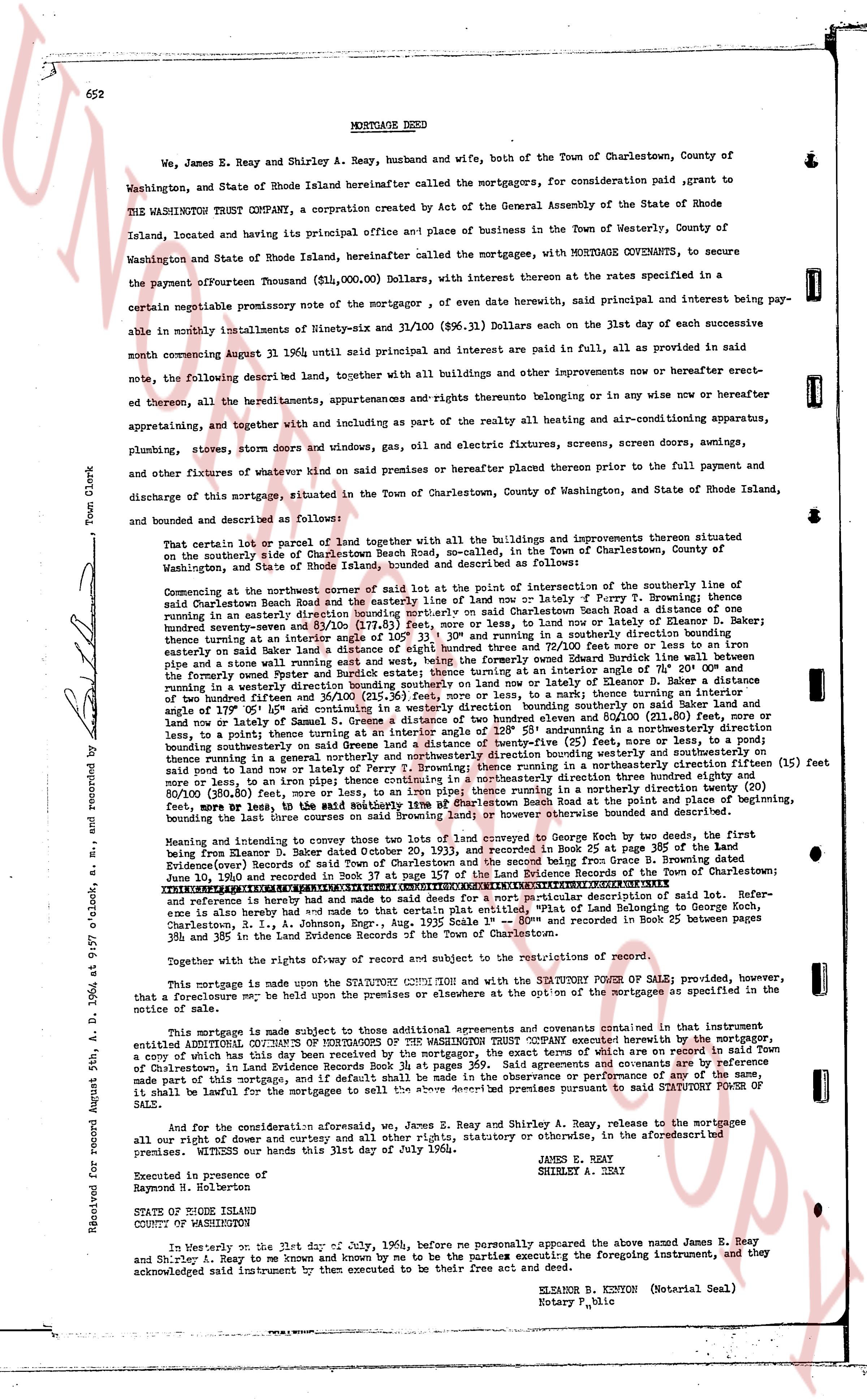
652 MORTGAGE DEED
We, James E. Reay and Shirley A. Reay, husband and wife, both of the Town of Charlestown, County of Washington, and State of Rhode Island hereinafter called the mortgagors, for consideration paid grant to the WASHINGTON TRUST COMPANY, a corporation created by Act of the General Assembly of the State of Rhode Island, located and having its principal office and place of business in the Town of Westerly, County of Washington and State of Rhode Island, hereinafter called the mortgagee, with MORTGAGE COVENANTS, to secure the payment of fourteen Thousand ($11,000.00) Dollars, with interest thereon at the rates specified in a certain promissory note the mortgagor of eve date herewith, said interest and principal being payable in monthly installments of Ninety-six and 31/100 ($96.31) Dollars on the 1st day of each successive month commencing August 31, 1964 until said principal and interest are paid in full, as provided in said note, the following described land, together with all buildings and other improvements now or hereafter erected thereon, all the hereditaments, appurtenances and rights thereunto belonging or in any wise now or hereafter attached, appertaining and together with in and including as part of the realty all heating and air-conditioning apparatus, plumbing, stoves, storm doors and windows, gas, oil and electric fixtures, screens, screen doors, awnings, and other fixtures of whatever kind now on said premises or hereafter placed thereon prior to the full payment and discharge of this mortgage, situated in the Town of Charlestown, County of Washington, and State of Rhode Island, and bounded and described as follows:
That certain lot or parcel of land together with all the buildings and improvements thereall situated on the southerly side of Washington Beach Road, no. one (1), in the Town of Charlestown, County of Washington, and State of Rhode Island, bounded and described as follows:
Commencing at the northwest corner of said lot at the point of intersection of the southerly line of said Charlestown Beach Road and the northerly line of said lot, namely Ferry P Brownly; thence running southerly an easterly direction bounding northerly on said Charlestown Beach Road a distance of one hundred seventy-seven and 89/100 (177.89) feet to a point marked by a nail in a stone wall; thence turning easterly on a line running south 15° 33' and turning in a southerly direction bounding thence turning at an easterly on said Baker land a distance of eight hundred three and 72/100 (803.72) feet to a stone wall marking the boundary between said Baker land and the land of Edward Burdick wall line between this and the formerly owned Pernet and Budker estate; thence turning at an easterly angle of 105° 30' a distance of two hundred fifty-four and 11/100 (254.11) feet, more or less, to a nail; thence turning an easterly angle of 120° 00' and running south 15° 33' a distance of two hundred fifty-four and 11/100 (254.11) feet, more or less, to a nail; thence turning an easterly angle of 105° 30' and running northerly on said line and now lotley of Samuel S. Green a distance of two hundred eighty-one and 00/100 (281.00) feet, more or less, to a nail; thence turning an easterly angle of 120° 00' and running northerly on said line and now lotley of Samuel S. Green a distance of two hundred fifty-four and 11/100 (254.11) feet, more or less, to a nail; thence turning an easterly angle of 105° 30' and running northerly on said line and now lotley of Samuel S. Green a distance of two hundred eighty-one and 00/100 (281.00) feet, more or less, to a nail; thence turning an easterly angle of 120° 00' and running northerly on said line and now lotley of Samuel S. Green a distance of two hundred eighty-one and 00/100 (281.00) feet, more or less, to a nail; thence turning an easterly angle of 105° 30' and running northerly on said line and now lotley of Ferry P Brownly; thence running in a northerly direction a certain fifteen (15) feet more or less, to an iron pipe; thence turning in a northerly direction a certain fifteen (15) feet more or less, to an iron pipe; thence turning in a northerly direction a certain twenty (20) feet, 80/100 (20.80) feet, more or less, to an iron pipe; thence turning in a northerly direction a certain twenty (20) feet, 80/100 (20.80) feet, more or less, to the said northwest corner of said lot at the point of beginning, bounding the land on the east by the land of Samuel S. Green or however otherwise bounded and described.
Meaning and intending to convey those two lots of land conveyed to George Echo by two deeds, the first being from Elanson D. Baker dated October 20, 1933, and recorded in Book 25 at page 357 of the Land Evidence Records of the Town of Charlestown; the second being from Elanson D. Baker dated October 20, 1933, and recorded in Book 25 at page 358 of the Land Evidence Records of the Town of Charlestown; and a third deed from Elanson D. Baker to George Echo dated June 10, 1940 and recorded in Book 37 at page 157 of the Land Evidence Records of the Town of Charlestown; reference is made hereto and to made deeds for sailed for a more particular description of said lot. Reference is also made to a map drawn by Elanson D. Baker, dated August 12, 1935, and recorded in the Town of Charlestown, R.I., a Johnston, Engr., Aug 12th 1935 Scale 1" = 80' and recorded in Book 25 between pages 365 and 366 in the Land Evidence Records of the Town of Charlestown.
Together with the rights of way of record and subject to the restrictions of record.
This mortgage is made on the record upon the SATISFACTION OF PRIOR SAILS of property, provided, reference is made hereto and to made deeds for sailed for a more particular description of the mortgages as specified in the notice of sale.
This mortgage is made subject to those additional experiments and covenants contained in that certain entitled ADDITIONAL COVENANTS OF THE MORTGAGOR containing trust executed hereby by the mortgagor, a copy of which has in this day been received by the mortgagor, the exact terms of which are on record in said town of Charlestown, R.I. and the mortgagor hereby agrees that said Additional Covenants and Agreements shall be made part of this mortgage, and if default shall be made in the observance or performance of any of the same, it shall be lawful for the mortgagee to sell the above described premises pursuant to said STATORY POWER OF SALE.
And for and consideration aforesaid, we, James E. Reay and Shirley A. Reay, release to the mortgagee all our right of dower and right of curtesy and all other right, statutory or otherwise, in the aforementioned described premises under this mortgage until this 31st day of July 1964.
Executed in presence of
Raymond N. Holbertson
STATE OF RHODE ISLAND
COUNTY OF WASHINGTON
Personally appeared on this 1st day of July, 1964, before me personally appeared the above named James E. Reay and Shirley A. Reay to me known and by me known to be the very persons executing the foregoing instrument, and they acknowledged said instrument by then executed to be their free act and deed.
ELANSON B. KENTON (Notarial Seal)
Notary Public
Received for record 5th A., 1964 at 9:59 o'clock, a.m. and recorded by
Town Clerk
The page as recorded