The instrument's own words
page 1 · read by Gemma vision
650
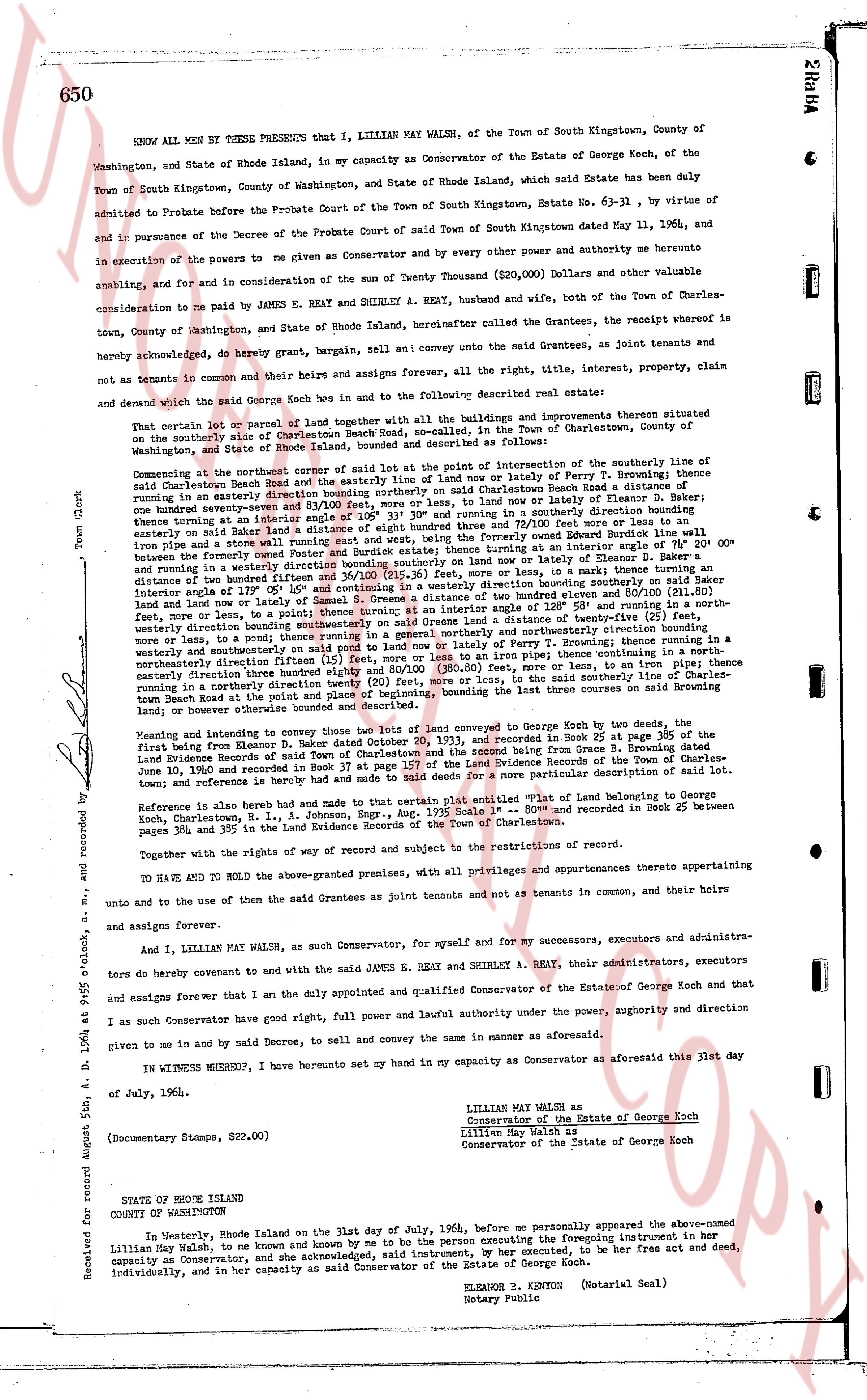
KNOW ALL MEN BY THESE PRESENTS that I, LILLIAN MAY WALSH, of the Town of South Kingstown, County of Washington, and State of Rhode Island, in my capacity as Conservator of the Estate of George Koch, of the Town of South Kingstown, County of Washington, and State of Rhode Island, which said Estate has been duly admitted to Probate before the Probate Court of the Town of South Kingstown, Estate No. 63-31, by virtue of and in pursuance of the Decree of the Probate Court of said Town of South Kingstown dated May 11, 1964, and in execution of the powers to me given as Conservator and by every other power and authority me heretofore enabling, and for and in consideration of the sum of Twenty Thousand ($20,000) Dollars and other valuable consideration to me paid by JAMES E. REAY and SHIRLEY A. REAY, husband and wife, both of the Town of Charlestown, County of Washington, and State of Rhode Island, hereinafter called the Grantees, the receipt whereof is hereby acknowledged, do hereby grant, bargain, sell and convey unto the said Grantees, as joint tenants and not as tenants in common and their heirs and assigns forever, all the right, title, interest, property, claim and demand which the said George Koch has in and to the following described real estate:
That certain lot or parcel of land together with all the buildings and improvements thereon situated within the boundaries of the village of City Beach Road, so called, in the Town of Charlestown, County of Washington, and State of Rhode Island, as the same is more or less particularly described as follows:
Commencing at the northwestern corner of said lot at the point of intersection of the southerly line of said City Beach Road, so called and the easterly line of land now or of late Perry T. Browning; thence running in an easterly direction bounding northerly on said lot acres or less, to land now or of late Elanor D. Baker; thence southerly bounding easterly on land now or of late Elanor D. Baker, a course N 15° 00' E, thence turning an angle interior or angle 155° 05' 30" and turning northerly and easterly for 72 and 100/100 feet more or less to an easterly line of land now or of late Perry T. Browning; thence running in a southerly direction bounding easterly on land now or of late Perry T. Browning at an interior angle of 78° 00' 00" from said iron pipe and a western route southerly and east west, bounding the formerly said lot at an interior angle of 78° 00' 00" from said iron pipe and a western route southerly and east west, bounding the formerly said lot at an interior angle of 78° 00' 00" from said iron pipe and a western route southerly and east west, bounding the formerly said lot at an interior angle of 78° 00' 00" from said iron pipe and a western route southerly and east west, bounding the formerly said lot at an interior angle of 78° 00' 00" from said iron pipe and a western route southerly and east west, bounding the formerly said lot at an interior angle of 78° 00' 00" from said iron pipe and a western route southerly and east west, bounding the formerly said lot at an interior angle of 78° 00' 00" from said iron pipe and a western route southerly and east west, bounding the formerly said lot at an interior angle of 78° 00' 00" from said iron pipe and a western route southerly and east west, bounding the formerly said lot at an interior angle of 78° 00' 00" from said iron pipe and a western route southerly and east west, bounding the formerly said lot at an interior angle of 78° 00' 00" from said iron pipe and a western route southerly and east west, bounding the formerly said lot at an interior angle of 78° 00' 00" from said iron pipe and a western route southerly and east west, bounding the formerly said lot at an interior angle of 78° 00' 00" from said iron pipe and a western route southerly and east west, bounding the formerly said lot at an interior angle of 78° 00' 00" from said iron pipe and a western route southerly and east west, bounding the formerly said lot at an interior angle of 78° 00' 00" from said iron pipe and a western route southerly and east west, bounding the formerly said lot at an interior angle of 78° 00' 00" from said iron pipe and a western route southerly and east west, bounding the formerly said lot at an interior angle of 78° 00' 00" from said iron pipe and a western route southerly and east west, bounding the formerly said lot at an interior angle of 78° 00' 00" from said iron pipe and a western route southerly and east west, bounding the formerly said lot at an interior angle of 78° 00' 00" from said iron pipe and a western route southerly and east west, bounding the formerly said lot at an interior angle of 78° 00' 00" from said iron pipe and a western route southerly and east west, bounding the formerly said lot at an interior angle of 78° 00' 00" from said iron pipe and a western route southerly and east west, bounding the formerly said lot at an interior angle of 78° 00' 00" from said iron pipe and a western route southerly and east west, bounding the formerly said lot at an interior angle of 78° 00' 00" from said iron pipe and a western route southerly and east west, bounding the formerly said lot at an interior angle of 78° 00' 00" from said iron pipe and a western route southerly and east west, bounding the formerly said lot at an interior angle of 78° 00' 00" from said iron pipe and a western route southerly and east west, bounding the formerly said lot at an interior angle of 78° 00' 00" from said iron pipe and a western route southerly and east west, bounding the formerly said lot at an interior angle of 78° 00' 00" from said iron pipe and a western route southerly and east west, bounding the formerly said lot at an interior angle of 78° 00' 00" from said iron pipe and a western route southerly and east west, bounding the formerly said lot at an interior angle of 78° 00' 00" from said iron pipe and a western route southerly and east west, bounding the formerly said lot at an interior angle of 78° 00' 00" from said iron pipe and a western route southerly and east west, bounding the formerly said lot at an interior angle of 78° 00' 00" from said iron pipe and a western route southerly and east west, bounding the formerly said lot at an interior angle of 78° 00' 00" from said iron pipe and a western route southerly and east west, bounding the formerly said lot at an interior angle of 78° 00' 00" from said iron pipe and a western route southerly and east west, bounding the formerly said lot at an interior angle of 78° 00' 00" from said iron pipe and a western route southerly and east west, bounding the formerly said lot at an interior angle of 78° 00' 00" from said iron pipe and a western route southerly and east west, bounding the formerly said lot at an interior angle of 78° 00' 00" from said iron pipe and a western route southerly and east west, bounding the formerly said lot at an interior angle of 78° 00' 00" from said iron pipe and a western route southerly and east west, bounding the formerly said lot at an interior angle of 78° 00' 00" from said iron pipe and a western route southerly and east west, bounding the formerly said lot at an interior angle of 78° 00' 00" from said iron pipe and a western route southerly and east west, bounding the formerly said lot at an interior angle of 78° 00' 00" from said iron pipe and a western route southerly and east west, bounding the formerly said lot at an interior angle of 78° 00' 00" from said iron pipe and a western route southerly and east west, bounding the formerly said lot at an interior angle of 78° 00' 00" from said iron pipe and a western route southerly and east west, bounding the formerly said lot at an interior angle of 78° 00' 00" from said iron pipe and a western route southerly and east west, bounding the formerly said lot at an interior angle of 78° 00' 00" from said iron pipe and a western route southerly and east west, bounding the formerly said lot at an interior angle of 78° 00' 00" from said iron pipe and a western route southerly and east west, bounding the formerly said lot at an interior angle of 78° 00' 00" from said iron pipe and a western route southerly and east west, bounding the formerly said lot at an interior angle of 78° 00' 00" from said iron pipe and a western route southerly and east west, bounding the formerly said lot at an interior angle of 78° 00' 00" from said iron pipe and a western route southerly and east west, bounding the formerly said lot at an interior angle of 78° 00' 00" from said iron pipe and a western route southerly and east west, bounding the formerly said lot at an interior angle of 78° 00' 00" from said iron pipe and a western route southerly and east west, bounding the formerly said lot at an interior angle of 78° 00' 00" from said iron pipe and a western route southerly and east west, bounding the formerly said lot at an interior angle of 78° 00' 00" from said iron pipe and a western route southerly and east west, bounding the formerly said lot at an interior angle of 78° 00' 00" from said iron pipe and a western route southerly and east west, bounding the formerly said lot at an interior angle of 78° 00' 00" from said iron pipe and a western route southerly and east west, bounding the formerly said lot at an interior angle of 78° 00' 00" from said iron pipe and a western route southerly and east west, bounding the formerly said lot at an interior angle of 78° 00' 00" from said iron pipe and a western route southerly and east west, bounding the formerly said lot at an interior angle of 78° 00' 00" from said iron pipe and a western route southerly and east west, bounding the formerly said lot at an interior angle of 78° 00' 00" from said iron pipe and a western route southerly and east west, bounding the formerly said lot at an interior angle of 78° 00' 00" from said iron pipe and a western route southerly and east west, bounding the formerly said lot at an interior angle of 78° 00' 00" from said iron pipe and a western route southerly and east west, bounding the formerly said lot at an interior angle of 78° 00' 00" from said iron pipe and a western route southerly and east west, bounding the formerly said lot at an interior angle of 78° 00' 00" from said iron pipe and a western route southerly and east west, bounding the formerly said lot at an interior angle of 78° 00' 00" from said iron pipe and a western route southerly and east west, bounding the formerly said lot at an interior angle of 78° 00' 00" from said iron pipe and a western route southerly and east west, bounding the formerly said lot at an interior angle of 78° 00' 00" from said iron pipe and a western route southerly and east west, bounding the formerly said lot at an interior angle of 78° 00' 00" from said iron pipe and a western route southerly and east west, bounding the formerly said lot at an interior angle of 78° 00' 00" from said iron pipe and a western route southerly and east west, bounding the formerly said lot at an interior angle of 78° 00' 00" from said iron pipe and a western route southerly and east west, bounding the formerly said lot at an interior angle of 78° 00' 00" from said iron pipe and a western route southerly and east west, bounding the formerly said lot at an interior angle of 78° 00' 0
The page as recorded