The instrument's own words
page 1 · read by Gemma vision
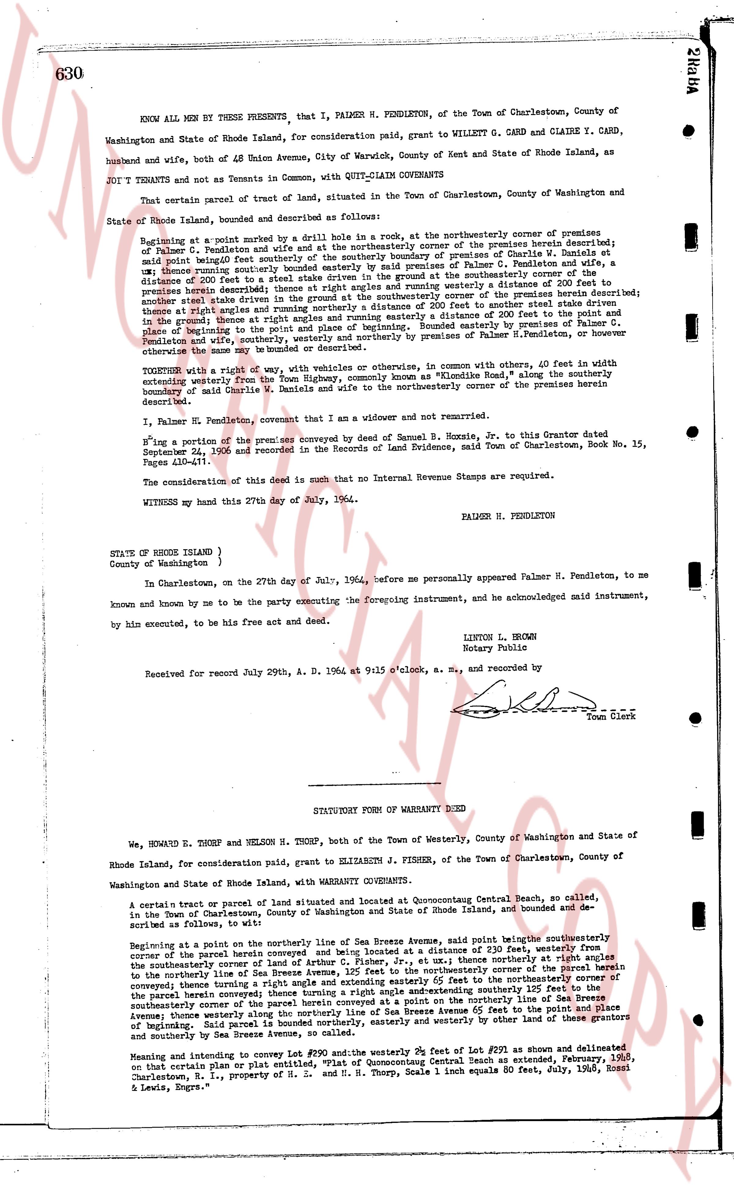
630
KNOW ALL MEN by THESE PRESENTS, that I, PALMER H. PENDLETON, of the Town of Charlestown, County of Washington and State of Rhode Island, for consideration paid, will grant to WILLETT G. CAND and CLAIRE Y. CAND, husband and wife, both of 48 Union Avenue, City of Warwick, County of Kent and State of Rhode Island, as JOINT TENANTS and not as Tenants in Common, with QUIT-CLAIM COVENANTS
That certain parcel of tract of land, situated in the Town of Charlestown, County of Washington and State of Rhode Island, bounded and described as follows:
Beginning at a point marked by a drilled hole 1 inch in row, at the northeasterly corner of premises of Palmer H. Pendleton and wife and at the northeasterly corner of the premises herein described; thence running southeasterly along said boundary line to the southerly boundary of premises of Charlie W. Daniels at said point being bounded southeasterly by said southerly boundary of premises of Charlie W. Daniels at said point, thence running southerly bounded easterly by a fence to a point of Palmer H. Pendleton's premises, a distance of 200 feet to a point marked by a drilled hole 1 inch in row at the ground southerly corner of the premises herein described thence at right angles and running westerly a distance of 110 feet to the northwest corner of the premises herein described thence at right angles and running westerly a distance of 200 feet to another steel drive stem in the ground thence at right angles and running northerly a distance of 110 feet to the northeast corner of the premises herein described thence at right angles and running northerly a distance of 200 feet to the point of beginning Bounded easterly by premises of Palmer H. Pendleton and wife southerly by premises of Charlie W. Daniels and northerly by premises of Palmer H. Pendleton, or whoever otherwise of the same may be bounded or described.
TOGETHER with a right of way, with vehicles or otherwise, in common with others, 40 feet in width extending westerly from the Town Highway, commonly known as "Kindred Road," along the southerly boundary of said Charlie W. Daniels and wife to the northwesterly corner of the premises herein described.
I, Palmer H. Pendleton, covenant that I am a widower and not remarried.
Hing a portion of the premises conveyed by deed of Samuel B. Hoxie, Sr. to this Grantor dated September 24, 1923 and recorded in the Records of Land Evidence, said Town of Charlestown, Book No. 15, Pages 410-411.
The consideration of this deed is such that no Internal Revenue Stamps are required.
WITNESS my hand this 27th day of July, 1964.
PALMER H. PENDLETON
STATE OF RHODE ISLAND )
County of Washington )
In Charlestown, on the 27th day of July, 1964, before me personally appeared Palmer H. Pendleton, to me known and by me to be the party executing the foregoing instrument, and acknowledged said instrument, by him executed, to be his free act and deed.
LINTON L. BROWN
Notary Public
Received for record July 29th A. D. 1964 at 9:15 o'clock, a. m., and recorded by
[Signature]
Town Clerk
----
STATUTORY FORM OF WARRANTY DEED
We, HOWARD E. THORP and NELSON H. THORP, both of the Town of Westerly, County of Washington and State of Rhode Island, for consideration paid, grant to ELIZABETH J. FISHER, of the Town of Charlestown, County of Washington and State of Rhode Island, with WARRANTY COVENANTS.
A certain tract or parcel of land situated and located at Quonocutong Centual Beach, so called, in the Town of Charlestown, County of Washington and State of Rhode Island, bounded and described as follows, to wit:
Beginning at a point on the northerly line of Sea Breeze Avenue, said point being the southeasterly corner of the parcel herein conveyed and being located at a distance of 230 feet, westerly from the southeasterly corner of the parcel herein conveyed and being located at a distance of 110 feet northerly from the southeasterly corner of the Sea Breeze Avenue, 125 feet to the northeasterly corner of the parcel herein conveyed thence running a right angle and extending easterly 200 feet to the northeasterly corner of the parcel herein conveyed thence running a right angle and extending southerly 125 feet to the southeasterly corner of the parcel herein conveyed at a point on the southerly line of Sea Breeze Avenue thence running westerly along the southerly line of Sea Breeze Avenue 200 feet to the point of place beginning Said parcel is bounded northerly, easterly and westerly by other land of these grantors and southerly by Sea Breeze Avenue.
Meaning and intending to convey Lot #190 and the westerly 39 feet of Lot #291 as shown and delineated on that certain Platname con or plat entitled, "Fisher's Concutual Beach as extended, February, 1965," Charlestown, R. I., property of H. S. and M. H. Thorp, Scale 1 inch equals 60 feet, July, 1963, Rossi & Lewis, Engrs."
page 2 · read by Gemma vision
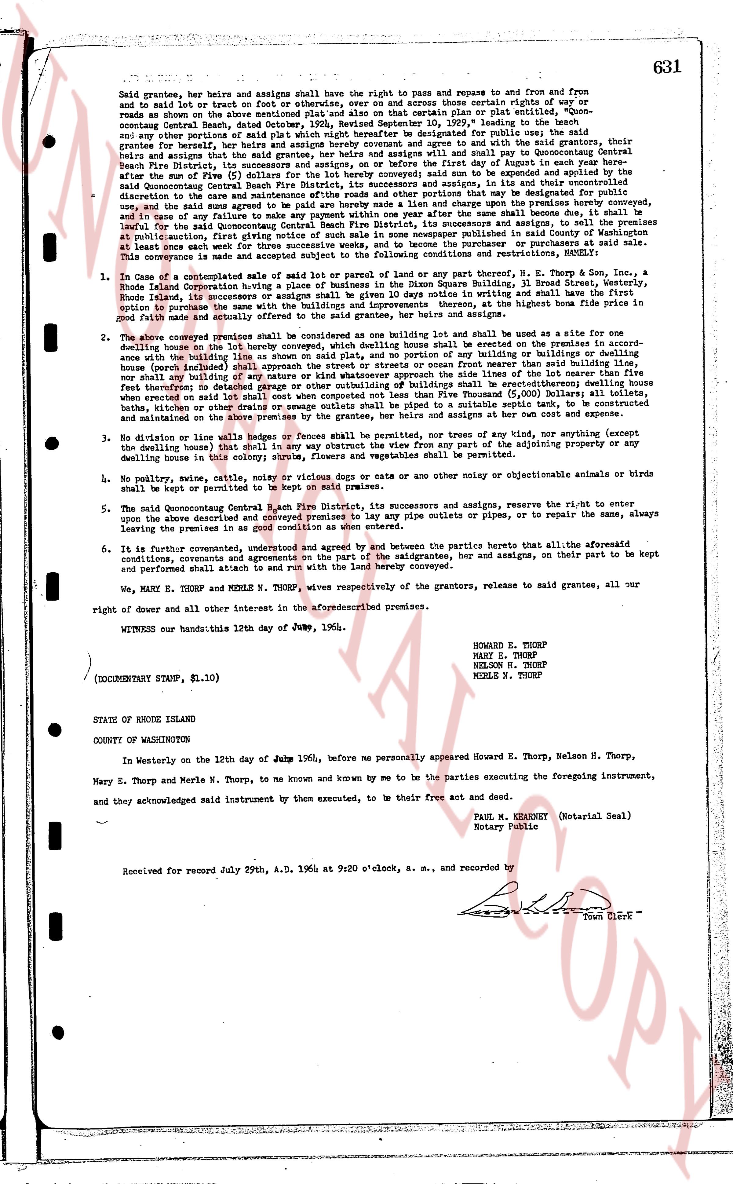
631
Said grantees, their heirs and assigns shall have the right to pass and repass to and from and from and to said lot or tract on foot or on hooves, or otherwise, over and across those certain rights of way or roads now or then used or then to be used for public use, as shown on certain plan or plat submitted to the Connecticut Coast Guard, dated October, 23rd, 1949, recorded September 10, 1929, leading to the beach and any other portions of said plat which might hereafter be designated for public use, and agree and bind themselves and their heirs and assigns to pay and agree to pay to the Secretary of the Coast Guard, Beach Patrol, its successors and assigns, the sum of Five Dollars ($5.00) on the first day of August in each year here after the sum of Five ($5) dollars (for the lot hereby conveyed) said sum to be extended and augmented by the application of Five percent (5%) interest per annum, for the use and benefit of the Coast Guard, and at the discretion of the care and maintenance affluents Rhode and other portions that way be designated for public use and for such uses and purposes as the Secretary of the Coast Guard, or its successors and assigns, may from time to time determine and in case of any failure to make any payment within one year after the same shall become due, it shall be lawful for the said Secretary of the Coast Guard, or its successors and assigns, to sell the said lot at public auction, the first giving notice of such sale in some newspaper published in said County of Washington at least once a week, and the sale shall be for the benefit of the Coast Guard, and the purchase of said lot.
This conveyance is made and subject accepted to the following conditions and restrictions, namely:
1. In case of a contemplated sale of said lot or parcel of land or any part thereof, N. E. Thorp & Sons, a Rhode Island Corporation having a place of business in the Town of Westerly, Rhode Island, shall have the first option to purchase the same at the price agreed upon in writing and shall have the first option with the purchase to the same with the buildings and improvements thereon, at the highest bone price filed in prior years.
2. The above conveyed premises shall be considered as one building lot and shall be used as a site for one dwelling house on the lot hereby conveyed, which dwelling house shall be erected in the approximate center of the above building lot, and no other building shall be erected on the premises except a garage or dwelling house (porch include) shall approach the street or streets or ocean front nearer than said building line, nor any building, fence, hedge or other structure shall be erected within twenty feet of the line of the adjacent building lot fence therefore; no detached porch or other outbuilding of such buildings shall be erected thereon; the dwelling house when erected on said lot shall be of two stories and shall not exceed twenty-five (25) feet in height, including the basement, but excluding the chimney, and sewage outlets shall be piped to a suitable septic tank, to be constructed and maintained on the above premises by the grantee, her heirs and assigns at her own cost and expense.
3. No division or line walls or hedges or fences shall be permitted, nor three tiers of any tree, nor anything (except the dwelling house) taller than 15 feet shall be erected on the premises, nor shall any structure be erected of the adjoining property or any dwelling house in this colony scheme, flowers and vegetables shall be permitted.
4. No poultry, swine, cattle, noisy or vicious dogs or cats or any other animal or objectionable animals or birds shall be kept or permitted to be kept on the premises.
5. The said Connecticut Coast Guard, 1st Fire District, its successors and assigns, reserves the right to enter upon the above described and conveyed premises to lay any pipe outlets or pipes or pits, or to repair the same, always leaving the premises in as good condition as when entered.
6. It is further covenanted, understood and agreed and called between the parties hereto that all the aforesaid conditions and covenants are agreed to on the part of the saidgrantee, her and assigns, on their part to be kept and performed shall attach to and run with the land hereby conveyed.
We, MARY E. THORP and MERLE N. THORP, wives respectively of the grantors, release to said grantee, all our right of dower and all other interest in the aforesaiddescribed premises.
WITNESS our hands this 12th day of June, 1964.
EDWARD E. THORP
MARY E. THORP
NELSON H. THORP
MERLE N. THORP
(DOCUMENT STAMP, $1.10)
STATE OF RHODE ISLAND
COUNTY OF WASHINGTON
In Westerly on the 12th day of June 1964, before me personally appeared Howard E. Thorp, Nelson H. Thorp, Mary E. Thorp and Merle N. Thorp, to me known and known by me to be the parties executing the foregoing instrument, and they acknowledged said instrument sealed by instrument, to their executions, to be their free act and deed.
PAUL M. KEANNEY (Notarial Seal)
Notary Public
Received for record July 29th, A.D. 1964 at 9:20 o'clock, a. m., and recorded by [?]
Town Clerk
The page as recorded