The instrument's own words
page 1 · read by Gemma vision
623
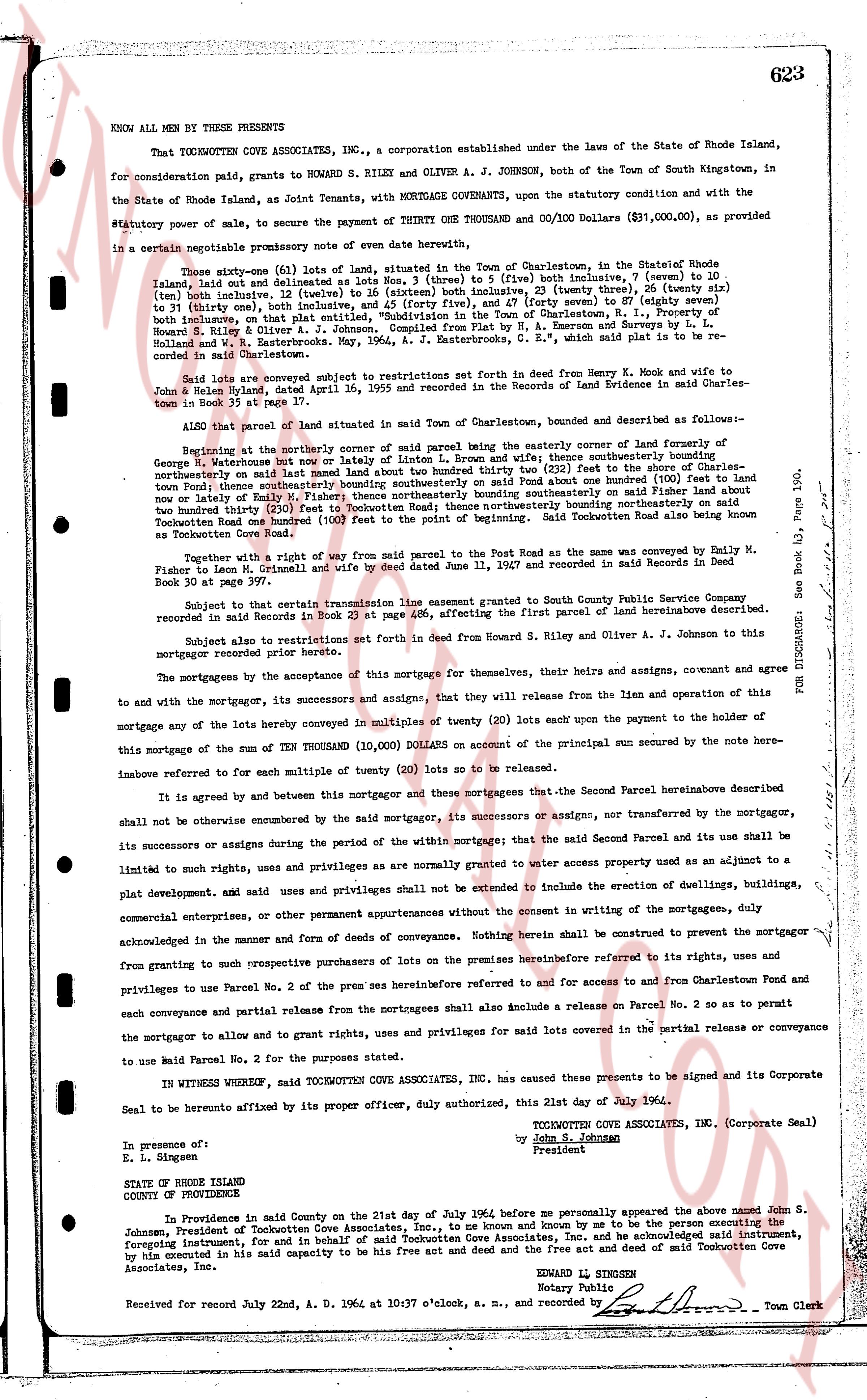
KNOW ALL MEN BY THESE PRESENTS
That TOCKWOTTEN COVE ASSOCIATES INC., a corporation established under the laws of the State of Rhode Island, for consideration paid, grants to HOWARD S. RILEY and OLIVER A. J. JOHNSON, both of the Town of South Kingstown, in the State of Rhode Island, as Joint Tenants, with MORTGAGE COVENANTS, upon the statutory condition and with the statutory power of sale, to secure the payment of THREE ONE THOUSAND Dollars & 00/100 Dollars ($31,000.00), as provided in a certain negotiable promissory note of even date hereinbefore,
Three sixty-one (461) Lots of land, situated in the Town of Charlestown, in the State of Rhode Island Island but not including as Lots Nos. 3 (three) to 5 (five) inclusive, 7 (seven) to 10 (ten) inclusive, 12 (twelve) to 16 (sixteen) inclusive, 23 (twenty three) to 25 (twenty five), 47 (forty seven) to 87 (eighty seven) inclusive, on that plat entitled, "Subdivision in the Town of Charlestown, R. I., Property of George W. Ketonious but now owned or lately owned by H. Brown and wife," and to Lots 26 (twenty six) to 46 (forty six) inclusive, and 88 (eighty eight) to 100 (one hundred) inclusive, on that plat entitled, "Subdivision in the Town of Charlestown, R. I., Property of George W. Ketonious but now owned or lately owned by A. S. Emerson and wife" by Deed in Land Evidence Book 35, page 118, Holland and W. A. Esterbrook, May 1, 1946, a Zestruction C. E., which plats are referred to in said recorded instruments;
Said Lots are encumbered subject to restrictions set forth in deed from Henry K. Mook and wife to John R. Riley handbag, dated April 16, 1955 and recorded in the Records of Land Evidence in said Charles Town in Book 35 at page 37 inclusive.
ALSO that parcel of land situated in said Town of Charlestown, bounded and described as follows:-
Beginning at the northeasterly corner of said parcel being the easterly corner of land formerly of George W. Ketonious but now owned or lately of latin L. Brown and wife; thence southerly bounding the Town of Rhode Island but not including as Lots Nos. 3 (three) to 5 (five) inclusive, 7 (seven) to 10 (ten) inclusive, 12 (twelve) to 16 (sixteen) inclusive, 23 (twenty three) to 25 (twenty five), 47 (forty seven) to 87 (eighty seven) inclusive, on that plat entitled, "Subdivision in the Town of Charlestown, R. I., Property of George W. Ketonious but now owned or lately owned by H. Brown and wife," and to Lots 26 (twenty six) to 46 (forty six) inclusive, and 88 (eighty eight) to 100 (one hundred) inclusive, on that plat entitled, "Subdivision in the Town of Charlestown, R. I., Property of George W. Ketonious but now owned or lately owned by A. S. Emerson and wife" by Deed in Land Evidence Book 35, page 118, Holland and W. A. Esterbrook, May 1, 1946, a Zestruction C. E., which plats are referred to in said recorded instruments;
Said Lots are encumbered subject to restrictions set forth in deed from Henry K. Mook and wife to John R. Riley handbag, dated April 16, 1955 and recorded in the Records of Land Evidence in said Charles Town in Book 35 at page 37 inclusive.
ALSO that parcel of land situated in said Town of Charlestown, bounded and described as follows:-
Beginning at the northerly corner of said parcel being the easterly corner of land formerly of George W. Ketonious but now owned or lately of latin L. Brown and wife; thence southerly bounding the Town of Rhode Island but not including as Lots Nos. 3 (three) to 5 (five) inclusive, 7 (seven) to 10 (ten) inclusive, 12 (twelve) to 16 (sixteen) inclusive, 23 (twenty three) to 25 (twenty five), 47 (forty seven) to 87 (eighty seven) inclusive, on that plat entitled, "Subdivision in the Town of Charlestown, R. I., Property of George W. Ketonious but now owned or lately owned by H. Brown and wife," and to Lots 26 (twenty six) to 46 (forty six) inclusive, and 88 (eighty eight) to 100 (one hundred) inclusive, on that plat entitled, "Subdivision in the Town of Charlestown, R. I., Property of George W. Ketonious but now owned or lately owned by A. S. Emerson and wife" by Deed in Land Evidence Book 35, page 118, Holland and W. A. Esterbrook, May 1, 1946, a Zestruction C. E., which plats are referred to in said recorded instruments;
Said Lots are encumbered subject to restrictions set forth in deed from Henry K. Mook and wife to John R. Riley handbag, dated April 16, 1955 and recorded in the Records of Land Evidence in said Charles Town in Book 35 at page 37 inclusive.
ALSO that parcel of land situated in said Town of Charlestown, bounded and described as follows:-
Beginning at the northerly corner of said parcel being the easterly corner of land formerly of George W. Ketonious but now owned or lately of latin L. Brown and wife; thence southerly bounding the Town of Rhode Island but not including as Lots Nos. 3 (three) to 5 (five) inclusive, 7 (seven) to 10 (ten) inclusive, 12 (twelve) to 16 (sixteen) inclusive, 23 (twenty three) to 25 (twenty five), 47 (forty seven) to 87 (eighty seven) inclusive, on that plat entitled, "Subdivision in the Town of Charlestown, R. I., Property of George W. Ketonious but now owned or lately owned by H. Brown and wife," and to Lots 26 (twenty six) to 46 (forty six) inclusive, and 88 (eighty eight) to 100 (one hundred) inclusive, on that plat entitled, "Subdivision in the Town of Charlestown, R. I., Property of George W. Ketonious but now owned or lately owned by A. S. Emerson and wife" by Deed in Land Evidence Book 35, page 118, Holland and W. A. Esterbrook, May 1, 1946, a Zestruction C. E., which plats are referred to in said recorded instruments;
Said Lots are encumbered subject to restrictions set forth in deed from Henry K. Mook and wife to John R. Riley handbag, dated April 16, 1955 and recorded in the Records of Land Evidence in said Charles Town in Book 35 at page 37 inclusive.
ALSO that parcel of land situated in said Town of Charlestown, bounded and described as follows:-
Beginning at the northerly corner of said parcel being the easterly corner of land formerly of George W. Ketonious but now owned or lately of latin L. Brown and wife; thence southerly bounding the Town of Rhode Island but not including as Lots Nos. 3 (three) to 5 (five) inclusive, 7 (seven) to 10 (ten) inclusive, 12 (twelve) to 16 (sixteen) inclusive, 23 (twenty three) to 25 (twenty five), 47 (forty seven) to 87 (eighty seven) inclusive, on that plat entitled, "Subdivision in the Town of Charlestown, R. I., Property of George W. Ketonious but now owned or lately owned by H. Brown and wife," and to Lots 26 (twenty six) to 46 (forty six) inclusive, and 88 (eighty eight) to 100 (one hundred) inclusive, on that plat entitled, "Subdivision in the Town of Charlestown, R. I., Property of George W. Ketonious but now owned or lately owned by A. S. Emerson and wife" by Deed in Land Evidence Book 35, page 118, Holland and W. A. Esterbrook, May 1, 1946, a Zestruction C. E., which plats are referred to in said recorded instruments;
Said Lots are encumbered subject to restrictions set forth in deed from Henry K. Mook and wife to John R. Riley handbag, dated April 16, 1955 and recorded in the Records of Land Evidence in said Charles Town in Book 35 at page 37 inclusive.
ALSO that parcel of land situated in said Town of Charlestown, bounded and described as follows:-
Beginning at the northerly corner of said parcel being the easterly corner of land formerly of George W. Ketonious but now owned or lately of latin L. Brown and wife; thence southerly bounding the Town of Rhode Island but not including as Lots Nos. 3 (three) to 5 (five) inclusive, 7 (seven) to 10 (ten) inclusive, 12 (twelve) to 16 (sixteen) inclusive, 23 (twenty three) to 25 (twenty five), 47 (forty seven) to 87 (eighty seven) inclusive, on that plat entitled, "Subdivision in the Town of Charlestown, R. I., Property of George W. Ketonious but now owned or lately owned by H. Brown and wife," and to Lots 26 (twenty six) to 46 (forty six) inclusive, and 88 (eighty eight) to 100 (one hundred) inclusive, on that plat entitled, "Subdivision in the Town of Charlestown, R. I., Property of George W. Ketonious but now owned or lately owned by A. S. Emerson and wife" by Deed in Land Evidence Book 35, page 118, Holland and W. A. Esterbrook, May 1, 1946, a Zestruction C. E., which plats are referred to in said recorded instruments;
Said Lots are encumbered subject to restrictions set forth in deed from Henry K. Mook and wife to John R. Riley handbag, dated April 16, 1955 and recorded in the Records of Land Evidence in said Charles Town in Book 35 at page 37 inclusive.
ALSO that parcel of land situated in said Town of Charlestown, bounded and described as follows:-
Beginning at the northerly corner of said parcel being the easterly corner of land formerly of George W. Ketonious but now owned or lately of latin L. Brown and wife; thence southerly bounding the Town of Rhode Island but not including as Lots Nos. 3 (three) to 5 (five) inclusive, 7 (seven) to 10 (ten) inclusive, 12 (twelve) to 16 (sixteen) inclusive, 23 (twenty three) to 25 (twenty five), 47 (forty seven) to 87 (eighty seven) inclusive, on that plat entitled, "Subdivision in the Town of Charlestown, R. I., Property of George W. Ketonious but now owned or lately owned by H. Brown and wife," and to Lots 26 (twenty six) to 46 (forty six) inclusive, and 88 (eighty eight) to 100 (one hundred) inclusive, on that plat entitled, "Subdivision in the Town of Charlestown, R. I., Property of George W. Ketonious but now owned or lately owned by A. S. Emerson and wife" by Deed in Land Evidence Book 35, page 118, Holland and W. A. Esterbrook, May 1, 1946, a Zestruction C. E., which plats are referred to in said recorded instruments;
Said Lots are encumbered subject to restrictions set forth in deed from Henry K. Mook and wife to John R. Riley handbag, dated April 16, 1955 and recorded in the Records of Land Evidence in said Charles Town in Book 35 at page 37 inclusive.
ALSO that parcel of land situated in said Town of Charlestown, bounded and described as follows:-
Beginning at the northerly corner of said parcel being the easterly corner of land formerly of George W. Ketonious but now owned or lately of latin L. Brown and wife; thence southerly bounding the Town of Rhode Island but not including as Lots Nos. 3 (three) to 5 (five) inclusive, 7 (seven) to 10 (ten) inclusive, 12 (twelve) to 16 (sixteen) inclusive, 23 (twenty three) to 25 (twenty five), 47 (forty seven) to 87 (eighty seven) inclusive, on that plat
The page as recorded