The instrument's own words
page 1 · read by Gemma vision
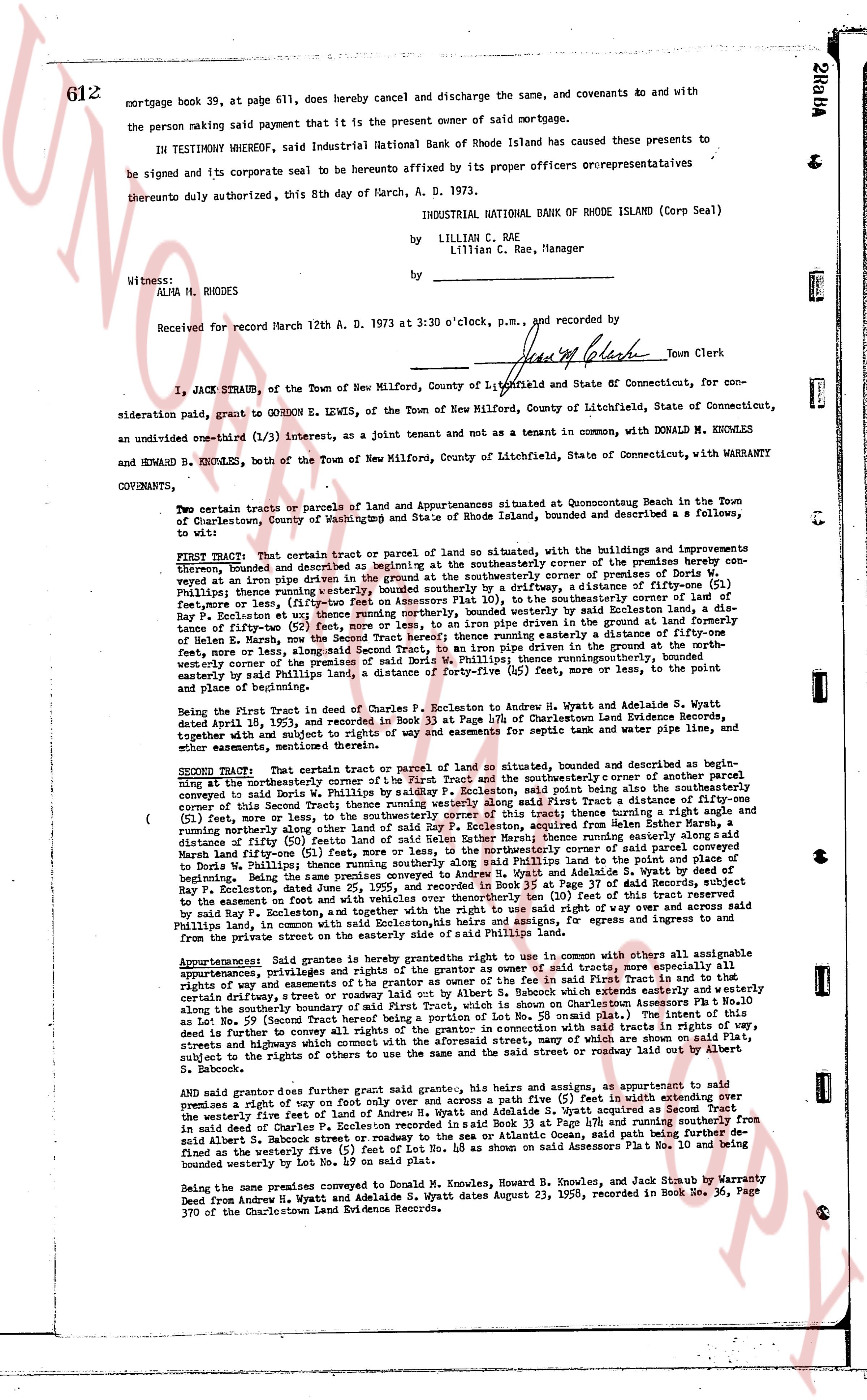
612
mortgage book 39, at page 611, does hereby cancel and discharge the same, covenants 40 and with any
the person making said payment that it is the present owner of said mortgage.
IN TESTIMONY WHEREOF, said Industrial National Bank of Rhode Island has caused these presents to
be signed and its corporate seal to be hereunto annexed by its proper officers or representatives
thereunto duly authorized, this 8th day of March, A. D. 1973.
INDUSTRIAL NATIONAL BANK OF RHODE ISLAND (Corp Seal)
by LILLIAN C. RAE
by Lillian C. Rae, Manager
Witness:
ALMA H. RHODES
Received for record March 12th A. D. 1973 at 3:30 o'clock, p.m., and recorded by
[Signature] Town Clerk
----
I, JACK STRAUB, of the Town of New Milford, County of Litchfield, State of Connecticut, for con-
sideration paid, grant to GORDON E LEWIS, of the Town of New Milford, County of Litchfield, State of Connecticut,
an undivided one-third (1/3) interest, as a joint tenant and not as a tenant in common with, DONALD M KNOWLES
and HOWARD B. KNOWLES, both of the Town of New Milford, County of Litchfield, State of Connecticut, with WARRANTY
COVENANTS,
To wit:
Two certain parcels or tracts of land and apartments situated at Quonochontaug Beach in the Town
of Charlestown, County of Washingtons and State of Rhode Island, bounded and described as follows, a
desc:
FIRST Tract: That certain tract or parcel of land so situated, with the buildings and improvements
theron, bounded and described as beginning at the southeasterly corner of the premises hereby con-
veyed as at an iron pipe set in ground at the southwesterly corner of premises conveyed in Book 33
Page 47, thence running westerly, bounded southerly by a driveway, of distance one-fifty (51) feet,
or more less, to an iron pipe, thence running northerly, bounded on the southeasterly corner of premises con-
veyed in Book 33 Page 47, east way thence running northerly, bounded westerly by Soilen land, a dis-
tance of fifty-two (52) feet, more or less, thence running easterly, driven in the ground a distance of one-fifty
feet, more or less, along the northern boundary of said premises conveyed in Book 33 Page 47, then
ce running north, the way then running easterly a distance of fifty-one feet,
more or less, along an existing fence, said Second Tract, to an iron pipe driven in the ground a distance of one-fifty
feet, more or less, along an existing fence, thence running northerly, thence running southwesterly, bounded
northwesterly corner of the premises conveyed in Book 33 Page 47, thence running southwesterly, bounded
easterly by said Phillips land, a distance of forty-five (45) feet, more or less, to point of and place of beginning.
Being the First in Tract in deed of Charles P. Escollton to Andrew H. Wyatt and Adelaide S. Wyatt
dated April 15, 1921, and recorded in Book 33 Page 47 of Charlestown Land Evidence records, together
with all rights, privileges, easements, appurtenances and advantages thereunto belonging and appertaining,
and other easements, mentioned therein.
SECOND Tract: That certain tract or parcel of land or sitio, bounded and described as begining at
an iron pipe driven in the ground at the North West corner and the southeasterly corner of another parcel
belonging to said Doris W. Phillips and the southerly corner of Escollton, said point being also the southeasterly
corner of this Second Tract thence running westerly a distance of one hundred four (104) feet, more or
less (51) feet, more or less, to an iron pipe, thence running northerly along other land of said Roy P. Escollton,
a distance of fifty (50) feet, more or less, thence running easterly along easterly side of said parcel of
land’s boundaries, then running southerly, bounded easterly by land of said Roy P. Escollton, a distance of
March half-fifty (50) feet, more or less, to the northeasterly corner of said parcel of land conveyed to
Fort Phillips in Book 33 Page 47 of Charlestown Land Evidence records, which point is the point of
beginning. Being the same premises conveyed to Andrew H. Wyatt and Adelaide S. Wyatt by deed of
party Grantor dated April 15, 1921, and recorded in Book 33 Page 47 of Charlestown Land Evidence records
to the easement on foot and with vehicles over and otherwise than ten (10) feet of this tract reserved
by said Roy P. Escollton, and further reserving a right of way for himself and his heirs and assigns to said
Phillips land, in common with said Escollton,his heirs and assigns, for egress and ingress to and from
the private street on the easterly side of the northeast corner of said tract.
Appurtenances: Said grants is made subject to the rights of the grantor as owner with others all advantages
appurtenances, privileges and rights the grantor as owner of said traits, more especially all
appurtenances, privileges and rights the writer as owner of the grantor as owner of said traits, including
rights of way through and over lands of said Roy P. Sabrock which extends easterly and westerly and
certain driveway along the southerly boundary of said First Tract, which is shown on Charlestown Assessors
Lot No. 59 Street View Map 1963, and all other reservations and restrictions contained in the intent of this
deed is further to convey all rights of the grantor in connection with said traits in rights of way,
streets and highways which are necessary for the convenient use and enjoyment of which the grantee is
subject to the rights of others to use the same and on the said street and roadway lie under the right of Albert
S. Sabrock.
And said grantor does further grant with right of way on foot only and over and across a path five (5) feet in width extending over
the westerly five feet of land of Gordon E Lewis, as shown on Assessors Plat No. 10 and running southerly as
in said deed of Charles P. Escollton recorded in said Book 33 Page 47 and running southerly from
said Albert S. Sabrock street or roadway to the sea or Atlantic Ocean, said running southerly from
bounded on the westerly five feet of land of Gordon E Lewis as shown on Assessors Plat No. 10 and being
bounded westerly by Lot No. 49 on said plat.
Being the same premises conveyed to Donald M. Knowles, Howard B. Knowles, and Jack Straub by Warranty
Deed from Andrew H. Wyatt and Adelaide S. Wyatt dated August 23, 1950, recorded in Book 36, Page
370 of the Charlestown Land Evidence Records.
page 2 · read by Gemma vision
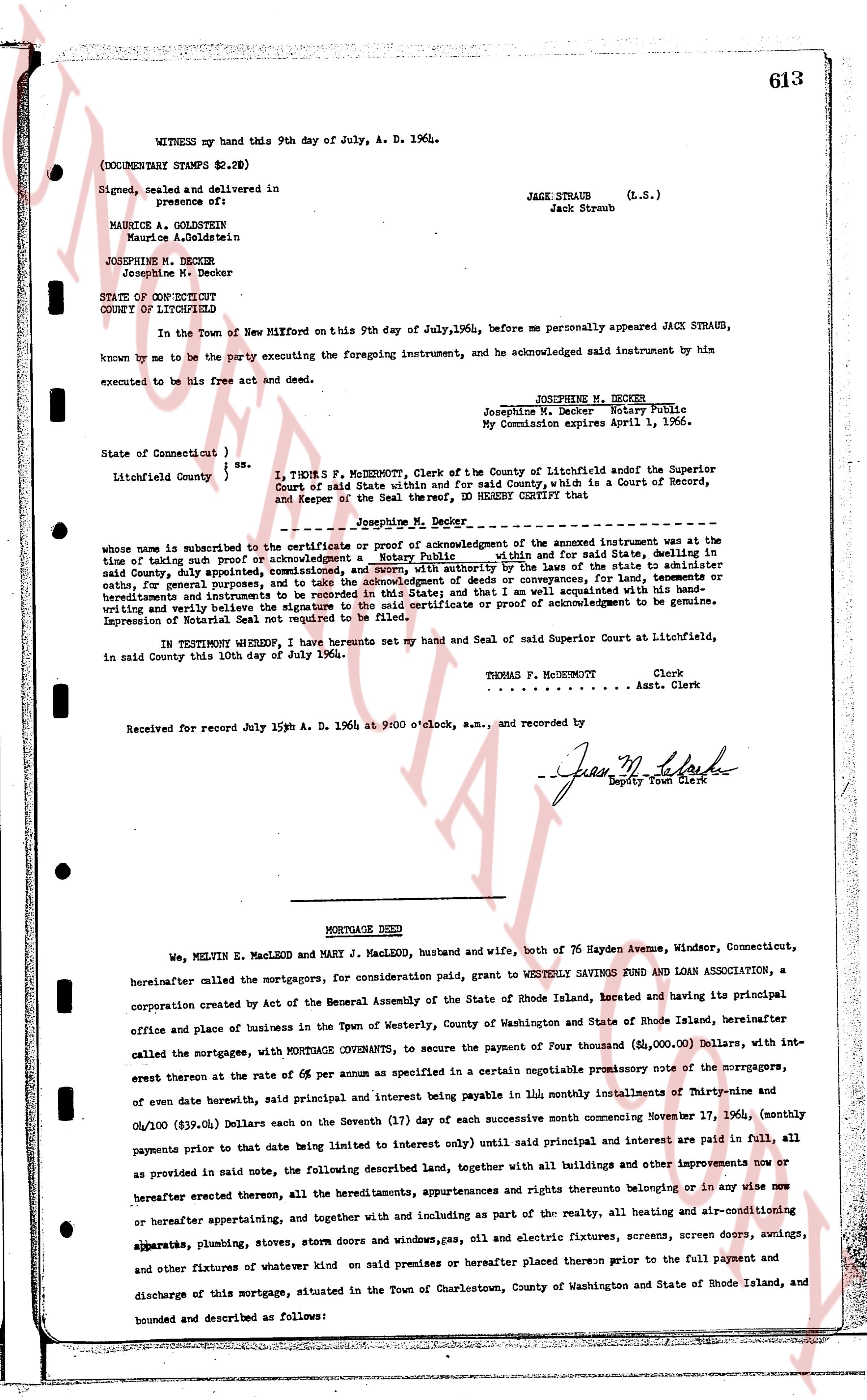
613
WITNESS my hand this 9th day of July, A. D. 1964.
(DOCUMENTARY STAMPS $2.78)
Signed, sealed and delivered in
presence of:
JACK STRAUB (L.S.)
Jack Straub
MAURICE A. GOLDSTEIN
Maurice A. Goldstein
JOSEPHINE M. DECKER
Josephine M. Decker
STATE OF CONNECTICUT
COUNTY OF LITCHFIELD ss.
In the Town of New Milford on this 9th day of July, 1964, before me personally appeared JACK STRAUB, known by me to be the party executing the foregoing instrument, and he acknowledged said instrument by him executed to be his free act and deed.
JOSEPHINE M. DECKER
Josephine M. Decker Notary Public.
My Commission expires April 1, 1966.
State of Connecticut } ss.
Litchfield County }
I, THOMAS F. MCUGHNORT, Clerk of the County of Litchfield and officer the Superior Court of said State within and for said County, which is a Court of Record, and Keeper of the Seal thereof, DO HEREBY CERTIFY that
Josephine M. Decker
whose name is subscribed to the verification or proof of acknowledgment of the above instrument was at the time of taking such proof an acknowledgment, a Notary Public and for said State, dwelling in said County, duly appointed, commissioned, and sworn, and with authority the use of the stamp to administer oaths, for general purposes, and to take the acknowledgment of any conveyance, for sale and purchase, for heirs, hereditaments and tenements in the State of Connecticut, and that I am well acquainted with his handwriting and verily believe the signature to the said certificate or proof of acknowledgment to be genuine.
Impression of Official Seal not required to be filed.
IN TESTIMONY WHEREOF I have hereunto set my hand and Seal of said Superior Court at Litchfield, in said County this 10th day of July 1964.
THOMAS F. MCUGHNORT Clerk.
[?] Asst. Clerk.
Received for record July 15th A. D. 1964 at 9:00 o'clock, a.m., and recorded by
Jas. M. Clark
Deputy Town Clerk
----
MORTGAGE DEED
We, MELVIN E. MACLEOD and MARY J. MACLEOD, husband and wife, both of 76 Hayden Avenue, Windsor, Connecticut, hereinafter called the mortgagors, for consideration paid, grant to WESTERLY SAVINGS FUND AND LOAN ASSOCIATION, a corporation created by Act of the General Assembly of the State of Rhode Island, located and having its principal office and place of business in the Town of Westerly, County of Washington and State of Rhode Island, hereinafter called the mortgagee, with MORTGAGE COVENANTS, to secure the payment of Four thousand ($4,000.00) Dollars, with interest thereon at the rate of 6% per annum as specified in a certain negotiable promissory note of the mortgagors, of even date herewith, said principal and interest being payable in 180 monthly installments of Ninety-nine and 8/100 ($99.01) Dollars each on the Severents (17) of day of each successive month commencing November 17, 1964, (monthly payments prior to that date being listed to interest only) until said principal and interest are paid in full, all as provided in said note, the following described land, together with all buildings and other improvements now or as provided in said note, all hereditaments, appurtenances and rights thereto belonging or in any wise now or hereafter erected thereon, all the hereditaments, appurtenances and rights thereto belonging or in any wise now or hereafter appertaining, and together with and including as parts of the realty, all the heating and air-conditioning apparatus, plumbing, stoves, storm doors and windows, gas, oil and electric fixtures, screens, screen doors, awnings, and other fixtures of whatever kind on said premises or hereafter placed thereon prior to the full payment and discharge of this mortgage, situated in the Town of Charlestown, County of Washington and State of Rhode Island, and bounded and described as follows:
The page as recorded