The instrument's own words
page 1 · read by Gemma vision
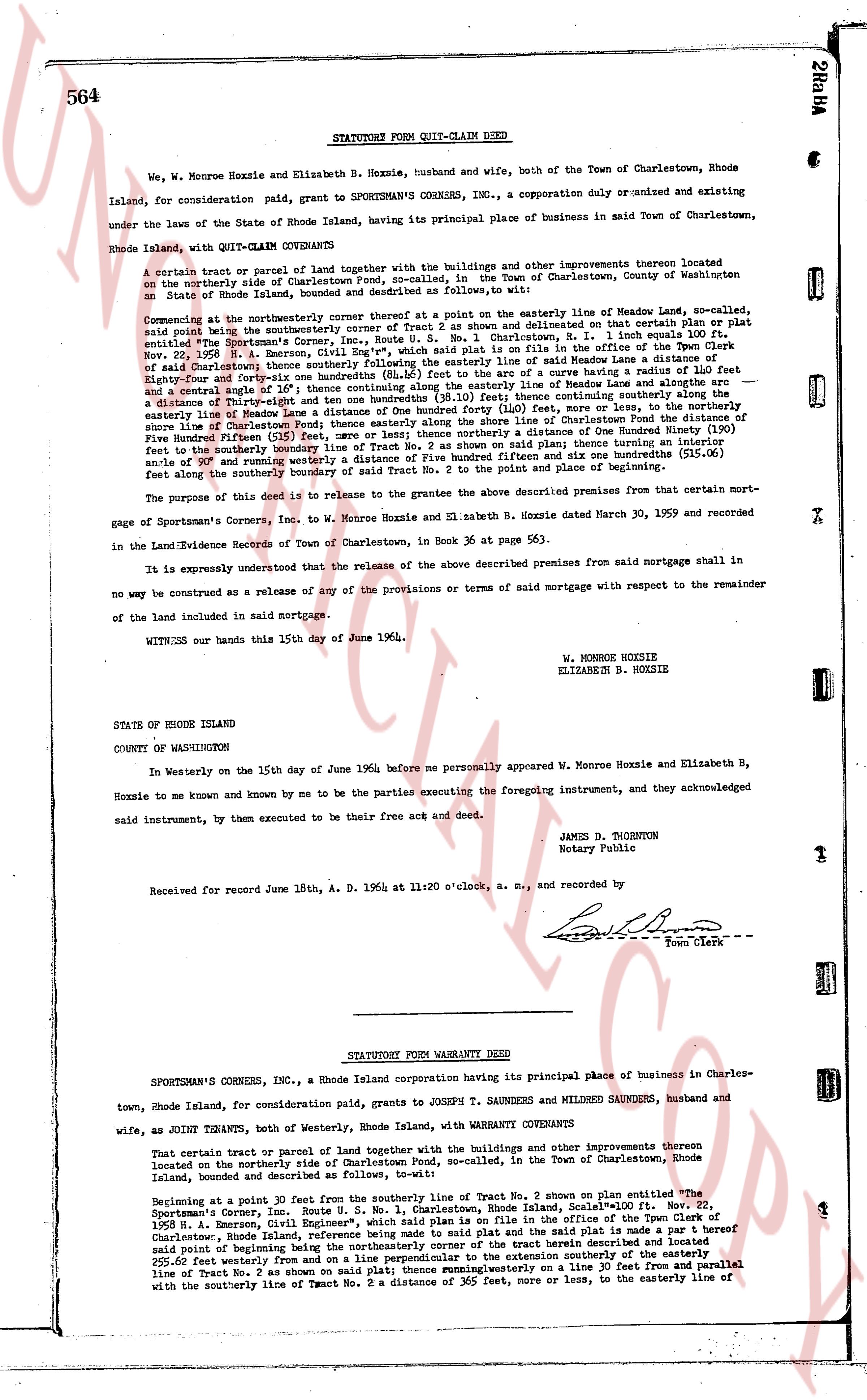
564 STATUTORY FORM QUIT-CLAIM DEED
We, W. Monroe Hoxxie and Elizabeth B. Hoxxie, husband and wife, both of the Town of Charlestown, Rhode Island, for consideration paid, grant to SPORTSMAN'S CORNERS INC., a corporation duly organized and existing under the laws of the State of Rhode Island, having its principal place of business in said Town of Charlestown, Rhode Island, with QUIT-CLAIM COVENANTS
A certain tract or parcel of land together with the buildings and other improvements thereon located on the northerly side of Charlestown Pond, so-called, in the Town of Charlestown, County of Washington in an State of Rhode Island, bounded and described as follows:
Commencing at the northerly western corner thereof at a stone as shown on that certain Plan or plat and also being the northerly western corner of Tract No. 2 as shown on that certain Plan, dated Nov. 20, 1959, by H. S. Chace, R.U.E. No. 5, 1 No. 1, Charlestown, Rhode Island, filed in the office of the Town Clerk entitled "The Sportsman's Corner, Inc., Route U. S. No. 1 Charlestown, Rhode Island," then running easterly along the easterly line of said Maine Leeds lane a distance of 110 feet [?] being the northerly boundary of said Tract No. 2, then running southerly along a curve having a radius of 110 feet and a central angle of 10° then running easterly along the easterly line of Maine Leeds lane and along the easterly boundary of said Tract No. 2 to a point where said boundary intersects the northerly shore line of Charlestown Pond, a distance of one hundred forty (140) feet, more or less, to the northerly shore line of Charlestown Pond, then running southerly along said northerly shore line of Charlestown Pond a distance of one hundred fifteen (115) feet, more or less; thence northerly a distance of One Hundred Ninety (190) feet to the southerly boundary line of Tract No. 2; thence westerly a distance of five hundred fifteen and one hundred six and one hundredths (515.06) feet along the southerly boundary of said Tract No. 2 to the point and place of beginning.
The purpose of this deed is to release to the grantees the above described premises from that certain mortgage of Sportsman's Corners, Inc. and W. Monroe Hoxxie and Elizabeth B. Hoxxie dated March 30, 1959 and recorded in the Land Evidence Records of Town of Charlestown, in Book 36 at page 553.
It is expressly understood that the release of the above described premises from said mortgage shall in no way be construed as a release of any of the provisions or terms of said mortgage with respect to the remainder of the land included in said mortgage.
WITNESS our hands this 15th day of June of 1964.
W. MONROE HOXXIE
ELIZABETH B. HOXXIE
STATE OF RHODE ISLAND
COUNTY OF WASHINGTON
In Westerly on the 15th day of June 1964 before me personally appeared W. Monroe Hoxxie and Elizabeth B. Hoxxie to me known and known by me to be the parties executing the foregoing instrument, and they acknowledged said instrument, by them executed to be their free act and deed.
JAMES D. THORNTON
Notary Public
Received and Record June 18th, A. D. 1964 at 11:20 o'clock, a. m., and recorded by
[Signature]
Town Clerk
----
STATUTORY FORM WARRANTY DEED
SPORTSMAN'S CORNERS, INC., a Rhode Island corporation having its principal place of business in Charlestown, Rhode Island, for consideration paid, grants to JOSEPH T. SAUNDERS and MILDRED SAUNDERS, husband and wife, as JOINT TENANTS, both of Westerly, Rhode Island, with WARRANTY COVENANTS
That certain tract or parcel of land together with the buildings and other improvements thereon located on the northerly side of Charlestown Pond, so-called, in the Town of Charlestown, Rhode Island, bounded and described as follows:
Beginning at a point 30 feet from the southerly line of Tract No. 2 shown on plan entitled "The Sportsman's Corner, Inc. Route U. S. No. 1, Charlestown, Rhode Island, Scale 1" by H. S. Chace, R.U.E. No. 5, 1959, a Registered Civil Engineer, filed in the office of the Town Clerk of Charlestown, Rhode Island, reference being made to said plat and the said plat is made a part hereof said point of beginning being the northeasterly corner of a certain tract described and sketched as follows: thence 250 feet westerly; thence northerly and perpendicular to the extension southerly of the easterly line of Tract No. 2, as shown on said plat; thence running westerly on a line 30 feet from and parallel with the southerly line of Tract No. 2 as shown on said plat; thence running westerly to the easterly line of Tract No. 2 a distance of 305 feet, more or less, to the easterly line of
page 2 · read by Gemma vision
565
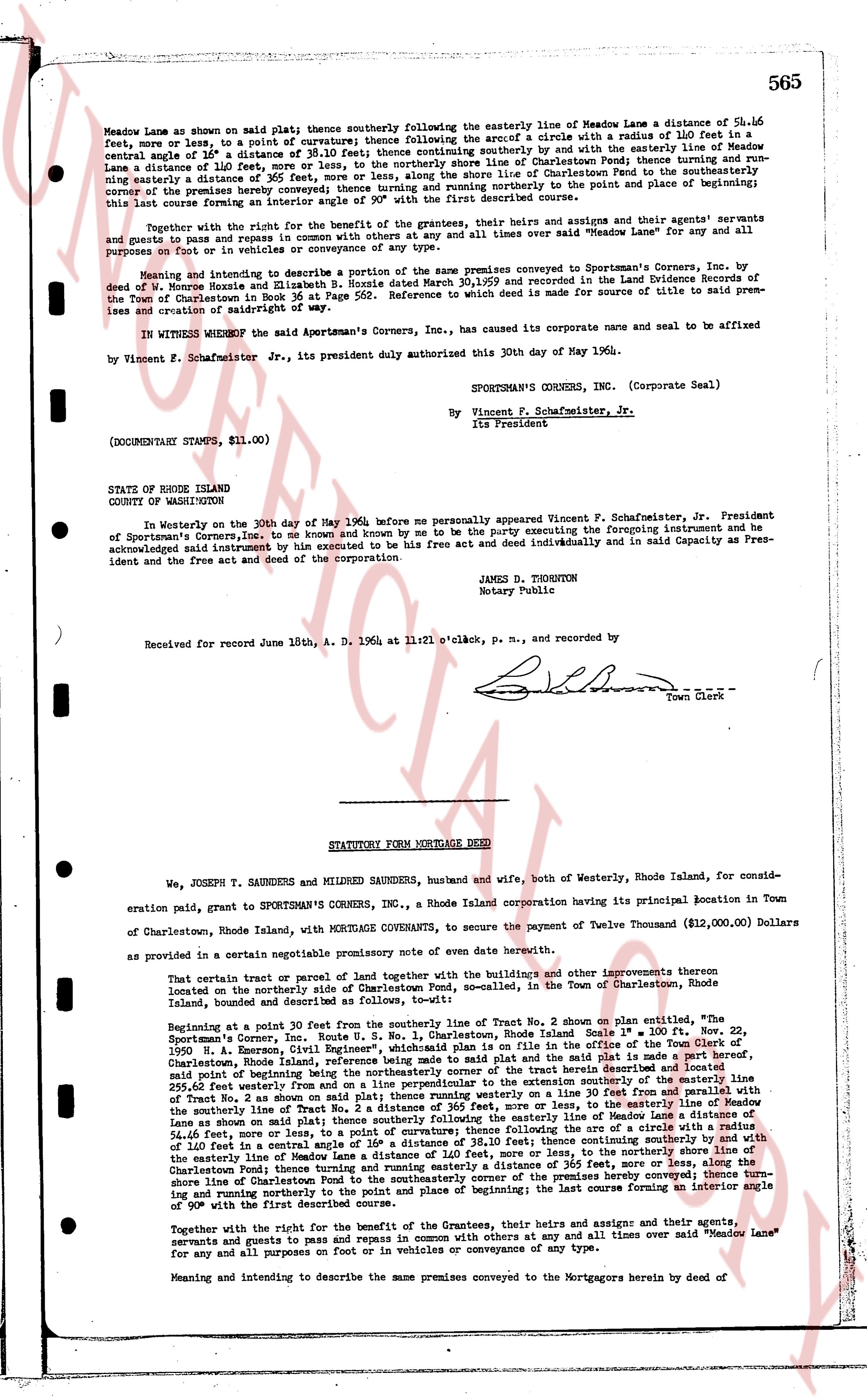
Meadow Lane as shown on said plat; thence southerly following the easterly line of Meadow Lane a distance of 56.16 feet, more or less, to a point of curvature thence continuing thence following the arc of a circle with a radius of 110 feet in a zenith angle of 1° 38' a distance of 38.10 feet; thence continuing southerly by and with the easterly line of Meadow Lane a distance of 110 feet, more or less, to the northerly shore line of Charlestown Pond; thence turning and running a distance of 365 feet, more or less, along the northerly shore line of Charlestown Pond to a point; thence turning northerly corner of the premises hereby conveyed; thence turning and running northerly to the point and place of beginning; this last course forming an interior angle of 90° with the first described course.
Together with the right for the benefit of the grantees, their heirs and assigns and their agents! servants and guests to pass and repass in common with others and at all times over said "Meadow Lane" for any and all purposes on foot or in vehicles of conveyance of any type.
Meaning and intending to describe a portion of the same premises conveyed to Sportsman's Corners, Inc. by deed dated June 11, 1936 and recorded in Book 30, page 569 and indexed in the Land Evidence Records of the Town of Charlestown in Book 36 at Page 562. Reference to such deed is made for source of title to said premises and creation of rightofway of said.
IN WITNESS WHEREOF the said Sportsman's Corners, Inc., has caused its corporate name and seal to be affixed by Vincent F. Schafmeister Jr., its president duly authorized this 30th day of May 1960.
SPORTSMAN'S CORNERS, INC. (Corporate Seal)
By Vincent F. Schafmeister, Jr.
its President
(DOCUMENTARY STAMPS, $11.00)
STATE OF RHODE ISLAND
COUNTY OF WASHINGTON
In Westerly on the 30th day of May 1960, before me personally appeared Vincent F. Schafmeister, Jr. President of Sportsman's Corners, Inc., to me known and known by me to be the party executing the foregoing instrument and he acknowledged and instrument by him executed to be his free act and deed individually and in said Capacity as President and the free act and deed of the corporation.
JAMES D. THORNTON
Notary Public
Received for record June 18th, A. D. 1964 at 11:21 o'clock, p. m., and recorded by
[Signature] Town Clerk
----
STATUTORY FORM MORTGAGE DEED
We, JOSEPH T. SAUNDERS and MILDRED SAUNDERS, husband and wife, both of Westerly, Rhode Island, for consideration paid, grant to SPORTSMAN'S CORNERS, INC., a Rhode Island corporation having its principal location in Town of Charlestown, Rhode Island, with MORTGAGE COVENANTS, to secure the payment of Twelve Thousand ($12,000.00) Dollars as provided in a certain negotiable promissory note of oven date herewith.
That certain tract or parcel of land together with the buildings and other improvements thereon strewn located on the northerly side of Charlestown Pond, m.s., located in the Town of Charlestown, Rhode Island, bounded and described as follows:
Beginning at a point 30 feet past the northerly line of Tract No. 2 shown on plat entitled, "the Sportsman's Corner, Route No. 1, U. S. Highway, Charlestown, Rhode Island Scale 1" = 100' ft. Nov. 22, 1950 N. H. Emerson, Civil Engineer", which plat is filed and recorded in the office of the Town Clerk of Charlestown, Rhode Island dated January 11, 1951; then continuing southerly on said plat and the said plat is made a part hereof, said point of beginning being the northwesterly corner of the tract herein conveyed; thence running southerly on the easterly line of Tract No. 2 shown on said plat thence running westerly a distance of 30 feet, more or less, to the easterly line of Meadow Lane as shown on said plat; thence southerly following the easterly line of Meadow Lane a distance of 56.16 feet, more or less, to a point of curvature thence continuing thence following the arc of a circle with a radius of 110 feet in a zenith angle of 1° 38' a distance of 38.10 feet; thence continuing southerly by and with the easterly line of Meadow Lane a distance of 110 feet, more or less, to the northerly shore line of Charlestown Pond; thence turning and running easterly a distance of 365 feet, more or less, along the shore line of Charlestown Pond to a point; thence turning northerly corner of the premises hereby conveyed; thence turning and running northerly to the point and place of beginning; the last course forming an interior angle of 90° with the first described course.
Together with the right for the benefit of the Grantees, their heirs and assigns and their agents, servants and guests to pass and repass in common with others and at all times over said "Meadow Lane" for any and all purposes on foot or in vehicles of conveyance of any type.
Meaning and intending to describe the same premises conveyed to the Mortgagors herein by deed of
The page as recorded