The instrument's own words
page 1 · read by Gemma vision
539
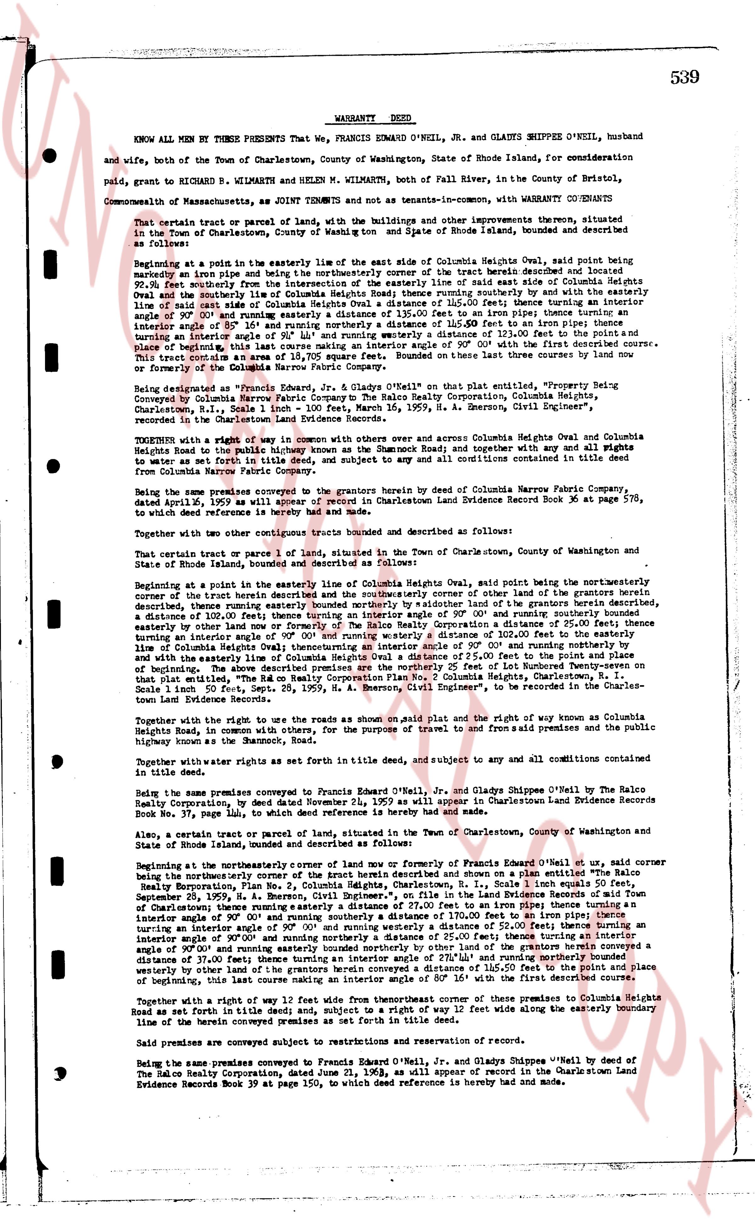
WARRANT DEED
KNOW ALL MEN by THESE PRESENTS That We, Francis Edward O'Neil, Jr. and Gladys Shippee O'Neil, husband and wife, both of the Town of Charlestown, County of Washington, State of Rhode Island, for consideration paid, grant to Richard B. Wilmarth, and Helen M. Wilmarth, both of Fall River, in the County of Bristol, Commonwealth of Massachusetts, and joint TENANTS and as tenants-in-common, with WARRANTY COURANTS In
That certain tract or parcel of land, with the buildings and other improvements thereon, situated in the town of Charlestown, County of Washington and State of Rhode Island, bounded and described as follows:
Beginning at a point in the rear line of the way now or formerly the Columbia Heights Oval, said point being due east marginally an iron pipe, and being the northeasterly corner of the tract herein described and located 90.00 feet marginally from the intersection of the easterly line of said east side of Columbia Heights Oval and the southerly line of Columbia Heights Road; thence running southerly by said easterly line of said east side of Columbia Heights Oval to the way now or formerly the Columbia Heights Oval, 115.00 feet; thence turning an interior angle of 90° 00' and running easterly a distance of 135.00 feet to an iron pipe; thence turning an interior angle of 90° 00' and running northerly a distance of 100.00 feet to an iron pipe; thence turning an interior angle of 180° 44' and running westerly a distance of 120.00 feet to the point and place of beginning, said tract being further limited to the east by the property of the heirs of Sarah Moore. This tract contains an area of 15,705 square feet. Bound on these three last courses by land now or formerly of Columbia Heights Road and Columbia Heights Oval.
Being relinquished as "Francis Edward, Jr. & Gladys O'Neil" on that plat entitled, "Property Being Conveyed by Columbia Norway Fabric Company to the Ralo Realty Corporation, Columbia Heights, Charlestown, R.I., Scale 1 inch = 50 feet, March 16, 1959, N. A. Bernoon, Civil Engineer", recorded in the Charlestown Land Evidence records.
TOGETHER with a right of way in common with others over and across Columbia Heights Oval and Columbia Heights Road to the public highway known as the Sannock Road, and together with any and all Rights to water as set forth in said deed, subject to and bound by all and any conditions contained in title derived from Columbia Norway Fabric Company
Being the same premises conveyed to the grantor herein described by Columbia Norway Fabric Company dated April 19, 1955 as will appear of record in Charlestown Land Evidence Record Book M page 579, to which deed reference is hereby made and said deed is made part hereof.
Together with one contiguous other two tracts bounded and described as follows:
That certain tract or parcel of land is situated, in the Town of Charlestown, County of Washington and State of Rhode Island, bounded and described as follows:
Beginning at a point in the easterly line of the way now or formerly Columbia Heights Oval, said point being the northeasterly corner of the tract herein described and being the southerly corner of the other grantor of the premises herein described, thence running easterly bounded northerly by a distance of 25.00 feet; thence turning an interior angle of 90° 00' and running southerly a distance of 90.00 feet; thence turning an interior angle easterly or northerly line now or formerly of the Ralo Realty Corporation a distance of 25.00 feet; thence turning an interior angle of 90° 00' and running northerly a distance of 105.00 feet to the point and place of beginning, line of Columbia Heights Oval; thence turning an interior angle of 90° 00' and running northerly by the easterly line of said east side of Columbia Heights Oval a distance of 15.00 feet to the point and place of beginning. The above described the premises are the northerly 25 feet of Lot Number Seventy-two on that plat entitled, "The Ralo Realty Corporation, Columbia Heights, Charlestown, R.I., Scale 1 inch = 50 feet, Sept. 29, 1959, N. A. Bernoon, Civil Engineer", to be recorded in the Charlestown Land Evidence records.
Together with the right to use the roads as shown on said plat and the right of way known as Columbia Heights Road, in common with others, for the purpose of travel to and from said premises and the public highway known as the Sannock Road,
Together with a water right as set forth in title deed, and subject to any and all conditions contained in title deed.
Being the same premises conveyed to Francis Edward O'Neil, Jr. and Gladys Shippee O'Neil by the Ralo Realty Corporation, by deed dated November 24, 1958, as will appear in Charlestown Land Evidence Records Book No. 37, page 111, to which deed reference is hereby made and said deed is made part hereof.
Also a certain tract or parcel of land, situated in the Town of Charlestown, County of Washington and State of Rhode Island, bounded and described as follows:
Beginning at the northeasterly corner of the street now or formerly Francis Edward O'Neil way, said corner being the northeasterly corner of the tract herein described and shown on a plat entitled "The Ralo Realty Corporation, Columbia Heights, Charlestown, R.I., Scale 1 inch = 50 feet, Sept. 29, 1959, N. A. Bernoon, Civil Engineer", on file in the Land Evidence records of Town Maid Charlestown, thence running southerly a distance of 100.00 feet; thence turning an interior angle of 90° 00' and running southerly a distance of 170.00 feet to an iron pipe; thence turning an interior angle of 90° 00' and running easterly a distance of 25.00 feet; thence turning an interior angle of 90° 00' and running northerly a distance of 25.00 feet; thence turning an interior angle of 90° 00' and running northerly a distance of 271.00 feet; thence turning an interior angle of 271.00 feet; thence turning an interior angle of 271.00 feet; thence turning an interior angle of 271.00 feet; thence turning an interior angle of 271.00 feet; thence turning an interior angle of 271.00 feet; thence turning an interior angle of 271.00 feet; thence turning an interior angle of 271.00 feet; thence turning an interior angle of 271.00 feet; thence turning an interior angle of 271.00 feet; thence turning an interior angle of 271.00 feet; thence turning an interior angle of 271.00 feet; thence turning an interior angle of 271.00 feet; thence turning an interior angle of 271.00 feet; thence turning an interior angle of 271.00 feet; thence turning an interior angle of 271.00 feet; thence turning an interior angle of 271.00 feet; thence turning an interior angle of 271.00 feet; thence turning an interior angle of 271.00 feet; thence turning an interior angle of 271.00 feet; thence turning an interior angle of 271.00 feet; thence turning an interior angle of 271.00 feet; thence turning an interior angle of 271.00 feet; thence turning an interior angle of 271.00 feet; thence turning an interior angle of 271.00 feet; thence turning an interior angle of 271.00 feet; thence turning an interior angle of 271.00 feet; thence turning an interior angle of 271.00 feet; thence turning an interior angle of 271.00 feet; thence turning an interior angle of 271.00 feet; thence turning an interior angle of 271.00 feet; thence turning an interior angle of 271.00 feet; thence turning an interior angle of 271.00 feet; thence turning an interior angle of 271.00 feet; thence turning an interior angle of 271.00 feet; thence turning an interior angle of 271.00 feet; thence turning an interior angle of 271.00 feet; thence turning an interior angle of 271.00 feet; thence turning an interior angle of 271.00 feet; thence turning an interior angle of 271.00 feet; thence turning an interior angle of 271.00 feet; thence turning an interior angle of 271.00 feet; thence turning an interior angle of 271.00 feet; thence turning an interior angle of 271.00 feet; thence turning an interior angle of 271.00 feet; thence turning an interior angle of 271.00 feet; thence turning an interior angle of 271.00 feet; thence turning an interior angle of 271.00 feet; thence turning an interior angle of 271.00 feet; thence turning an interior angle of 271.00 feet; thence turning an interior angle of 271.00 feet; thence turning an interior angle of 271.00 feet; thence turning an interior angle of 271.00 feet; thence turning an interior angle of 271.00 feet; thence turning an interior angle of 271.00 feet; thence turning an interior angle of 271.00 feet; thence turning an interior angle of 271.00 feet; thence turning an interior angle of 271.00 feet; thence turning an interior angle of 271.00 feet; thence turning an interior angle of 271.00 feet; thence turning an interior angle of 271.00 feet; thence turning an interior angle of 271.00 feet; thence turning an interior angle of 271.00 feet; thence turning an interior angle of 271.00 feet; thence turning an interior angle of 271.00 feet; thence turning an interior angle of 271.00 feet; thence turning an interior angle of 271.00 feet; thence turning an interior angle of 271.00 feet; thence turning an interior angle of 271.00 feet; thence turning an interior angle of 271.00 feet; thence turning an interior angle of 271.00 feet; thence turning an interior angle of 271.00 feet; thence turning an interior angle of 271.00 feet; thence turning an interior angle of 271.00 feet; thence turning an interior angle of 271.00 feet; thence turning an interior angle of 271.00 feet; thence turning an interior angle of 271.00 feet; thence turning an interior angle of 271.00 feet; thence turning an interior angle of 271.00 feet; thence turning an interior angle of 271.00 feet; thence turning an interior angle of 271.00 feet; thence turning an interior angle of 271.00 feet; thence turning an interior angle of 271.00 feet; thence turning an interior angle of 271.00 feet; thence turning an interior angle of 271.00 feet; thence turning an interior angle of 271.00 feet; thence turning an interior angle of 271.00 feet; thence turning an interior angle of 271.00 feet; thence turning an interior angle of 271.00 feet; thence turning an interior angle of 271.00 feet; thence turning an interior angle of 271.00 feet; thence turning an interior angle of 271.00 feet; thence turning an interior angle of 271.00 feet; thence turning an interior angle of 271.00 feet; thence turning an interior angle of 271.00 feet; thence turning an interior angle of 271.00 feet; thence turning an interior angle of 271.00 feet; thence turning an interior angle of 271.00 feet; thence turning an interior angle of 271.00 feet; thence turning an interior angle of 271.00 feet; thence turning an interior angle of 271.00 feet; thence turning an interior angle of 271.00 feet; thence turning an interior angle of 271.00 feet; thence turning an interior angle of 271.00 feet; thence turning an interior angle of 271.00 feet; thence turning an interior angle of 271.00 feet
page 2 · read by Gemma vision
540
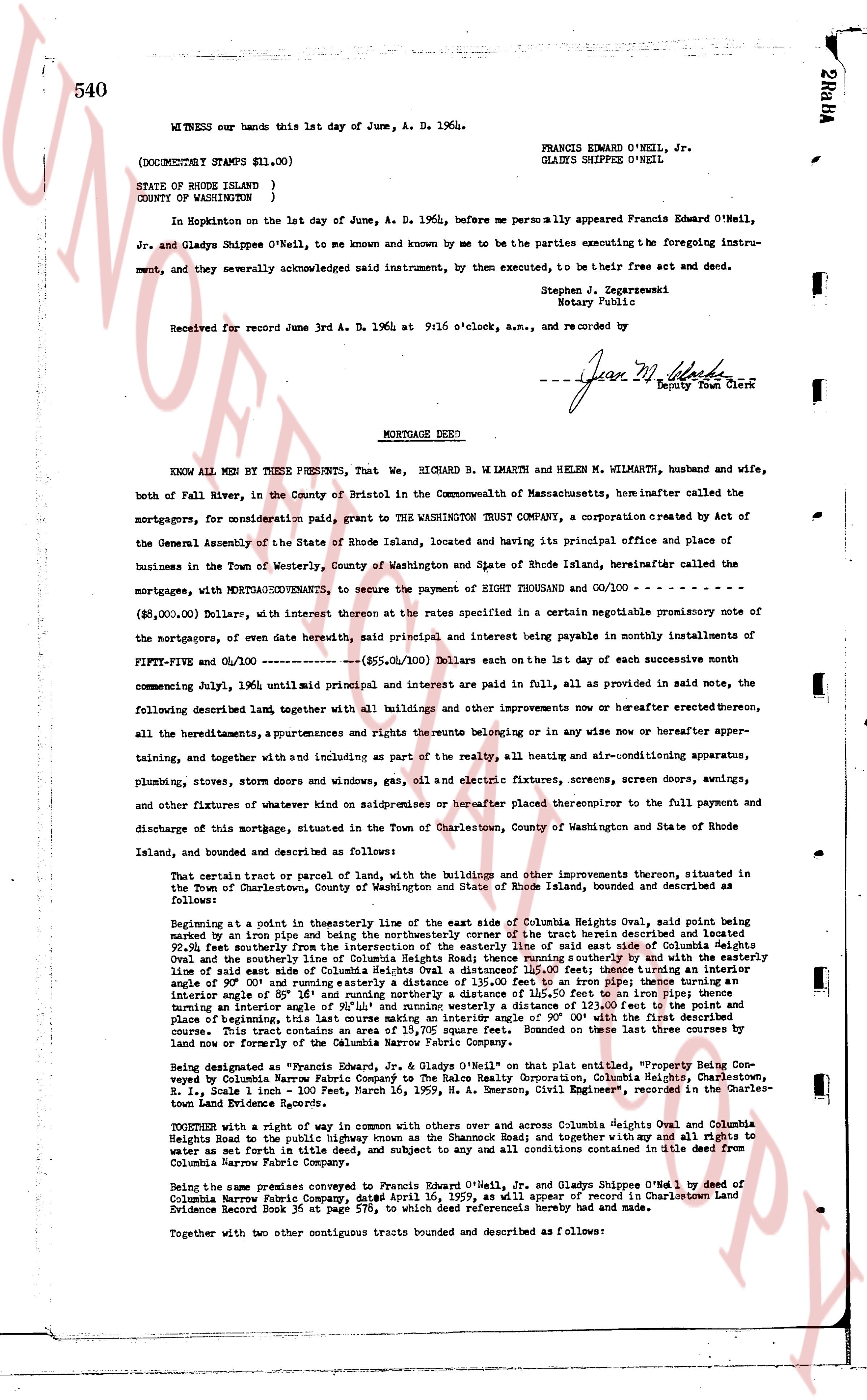
WITNESS our hands this 1st day of June, A. D. 1964.
FRANCIS EDWARD O'NEIL, Jr.
GLADYS SHIPPEE O'NEIL
(DOCUMENTARY STAMPS $11.00)
STATE OF RHODE ISLAND )
COUNTY OF WASHINGTON )
In Hopkinton on the 1st day of June, A. D. 1964, before me personally appeared Francis Edward O'Neil, Jr. and Gladys Shippee O'Neil, to me known and by me to be the parties executing the foregoing instrument, and they severally acknowledged said instrument, by them executed, to be their free act and deed.
Stephen J. Zegarznawski
Notary Public
Received for record June 3rd A. D. 1964 at 9:15 o'clock, a.m., and recorded by
[Signature]
Deputy Town Clerk
----
MORTGAGE DEED
KNOW ALL MEN BY THESE PRESENTS, That We, RICHARD B. WILMARTH and HELEN M. WILMARTH, husband and wife, both of Fall River, in the County of Bristol in the Commonwealth of Massachusetts, hereinafter called the mortgagors, for consideration paid, grant to THE WASHINGTON TRUST COMPANY, a corporation created by Act of the General Assembly of the State of Rhode Island, located and having its principal office and place of business in the Town of Westerly, County of Washington and State of Rhode Island, hereinafter called the mortgagee, with MORTGAGE COVENANTS, to secure the payment of EIGHT THOUSAND and 00/100 --- ($8,000.00) Dollars, with interest thereon at the rates specified in a certain negotiable promissory note of the mortgagors, of even date herewith, said principal and interest being payable in monthly installments of FIFTY-FIVE and 00/100 --- ($55.00) Dollars on the 1st day of each successive month commencing July, 1964, until principal and interest are paid in full, all as provided in said note, the following described land together with all buildings and other improvements now or hereafter erected thereon, all the hereditaments, a purtenances and rights thereunto belonging in or any wise now or hereafter appertaining, and together with and including as part of the realty, all heating and air-conditioning apparatus, plumbing, stoves, doors and windows, glass, oil and electric fixtures, screens, screen doors, awnings, and other fixtures of whatever kind on said premises or hereafter placed thereonprior to the Full payment and discharge of this mortgage, situated in the Town of Charlestown, County of Washington and State of Rhode Island, bounded and described as follows:
That certain parcel of land or parcel of land, with the buildings and other improvements thereon, situated in the Town of Charlestown, County of Washington and State of Rhode Island, bounded and described as follows:
Beginning at a point in the centerline of the line of the east side of Columbia Heights Oval, said point being marked by an iron pipe and being the southeasterly corner of the tract herein described and located 92.9 feet southerly from the intersection of the easterly centerline of the east side of Columbia Heights Oval and the southerly centerline of the line of the east side of Columbia Heights Oval, thence running easterly along said southerly centerline of the line of the east side of Columbia Heights Oval a distance 100.00 feet to an iron pipe; thence turning an angle of 90° 00' and running easterly a distance 135.00 feet to an iron pipe; thence turning an angle of 90° 00' and running southerly a distance 100.00 feet to an iron pipe; thence turning an angle of 90° 00' and running westerly a distance 135.00 feet to the point and pipe of beginning, thence turning an angle of 90° 00' and running northerly 100.00 feet to the point and curve on the easterly side of Columbia Heights Oval, thence running northerly along said curve to the point of beginning. This tract contains an area of 13,705 square feet. The boundary on three courses lastly described is now formerly that of a fence.
Being designated as "Francis Edward, Jr. & Gladys O'Neil's lot" on that plat certified by Columbia Narrow Fabric Company Brokered to the Hale Realty Organization, Columbia Heights, Charlestown, R.I., Scale 1 inch = 100 feet, March 16, 1959, H. A. Benson, Civil Engineer, recorded in the Charlestown Land Evidence Book 36 page 576.
TOGETHER with a right of way in common with others over and across Columbia Heights Oval and Columbia Heights Road to the public highway known as the Shoremede Road; and together with my and our title to and rights with as set forth in the deed to us, and subject to the restrictions contained in the deed from Columbia Narrow Fabric Company.
Being the same premises conveyed to Francis Edward O'Neil, Jr. and Gladys Shippee O'Neil by deed of Columbia Narrow Fabric Company, dated April 16, 1959, as will appear of record in Charlestown Land Evidence Book Record 36 at page 576, to which deed reference hereby made and had.
Together with two other contiguous tracts bounded and described as follows:
The page as recorded