The instrument's own words
page 1
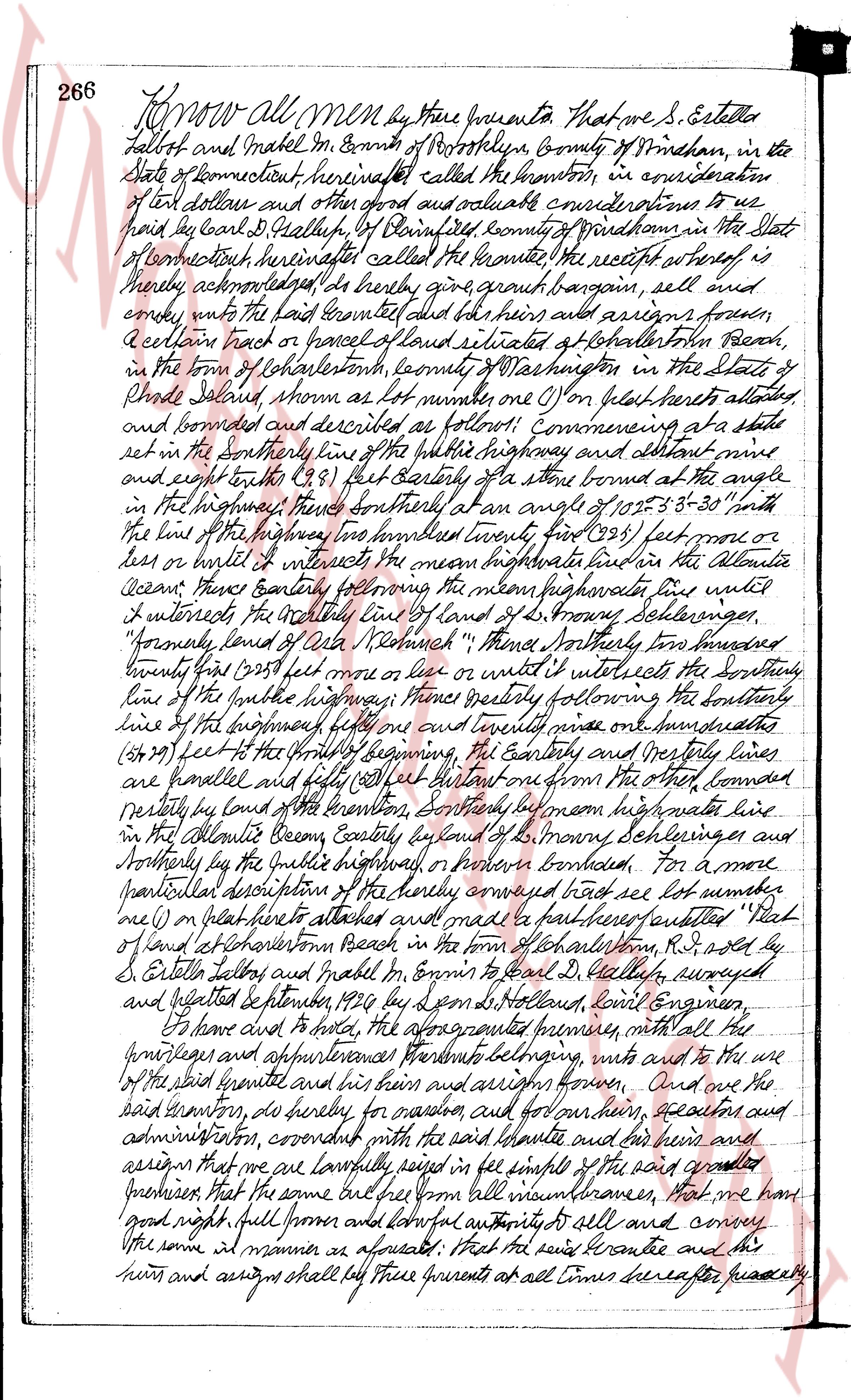
266 Know all Men by these presents That we S. Estella
Halbot and Mabel M. Espin of New London County of New London in the
State of Connecticut hereinafter called the grantors, in consideration
of ten dollars and other good and valuable considerations to us
paid by Carl D. Heathly of New London county of New London in the State
of Connecticut hereinafter called the grantee the receipt whereof is
hereby acknowledged do hereby give grant bargain sell and
convey unto the paid grantee and his heirs and assigns forever
a certain tract or parcel of land situated at Charlestown Beach
in the town of Charlestown county of Washington in the State of
Rhode Island known as lot number one (1) on plat hereunto attached
and bounded and described as follows: Commencing at a stake
set in the Southerly line of the public highway and distant nine
and eight tenths (9.8) feet Easterly of the stone bound at the angle
in the highway then Southerly at an angle of 105° 53' 30" with
the line of the highway then Southeasterly two hundred twenty (220) feet more
or less or until it intersects the mean high water line in the Atlantic
Ocean then Easterly following the mean high water line until
it intersects the Southerly line of land of G. Browning Schulerings
"formerly land of Ada Winship" then Southerly two hundred
twenty five (225) feet more or less or until it intersects the Southerly
line of the public highway then westerly following the Southerly
line of the highway one and one quarter miles one hundred seventy
(1.270) feet to the point of beginning the Easterly and Westerly lines
are parallel and fifty (50) feet distant one from the other bounded
northerly by land of the grantor Southerly by mean high water line
in the Atlantic Ocean Easterly by land of G. Browning Schulerings and
northerly by the public highway or portion bounded For a more
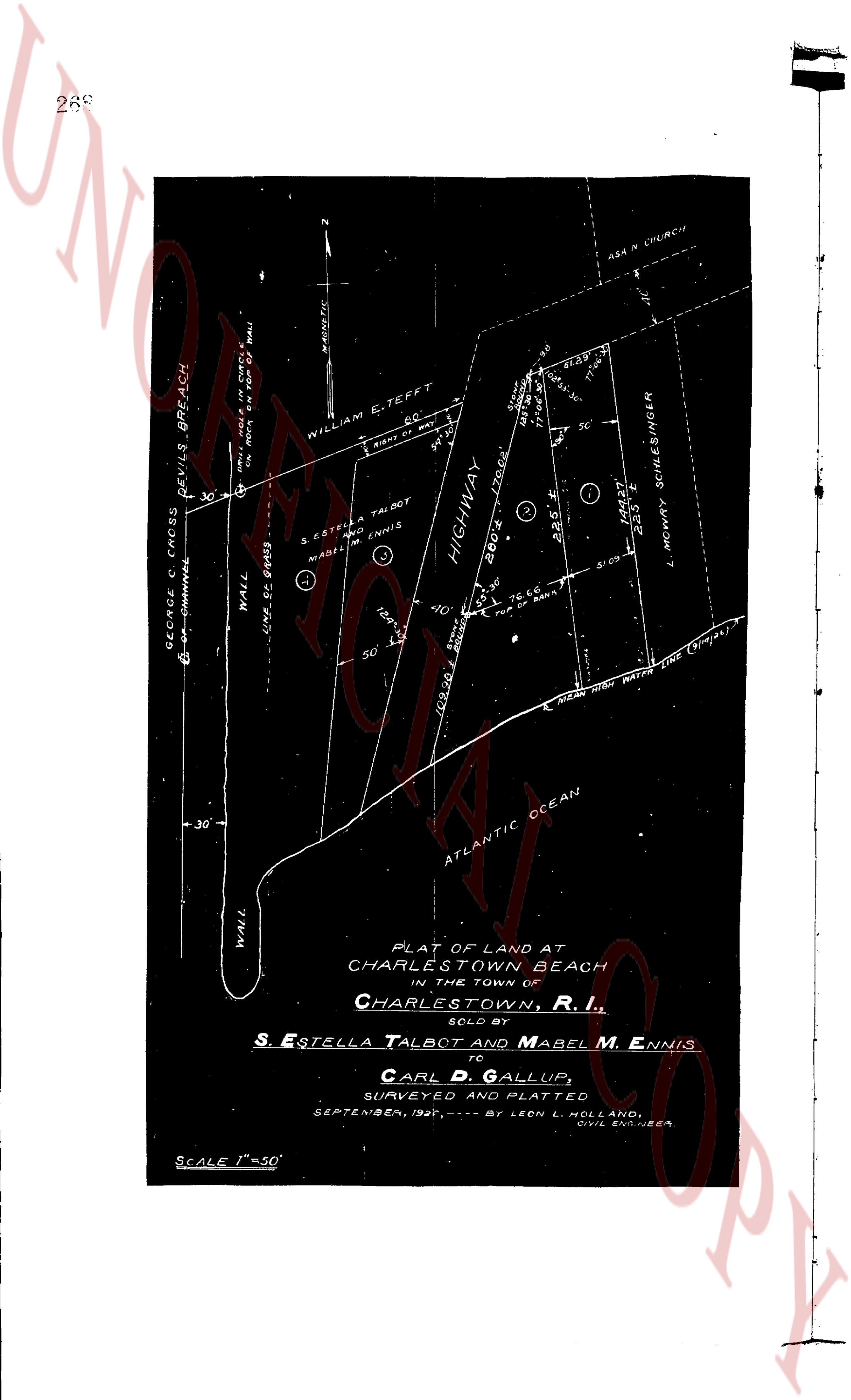
particular description of the hereby conveyed tract see lot number
one (1) on plat hereunto attached and made part hereof entitled "Plat of
land at Charlestown Beach in the town of Charlestown, R.I. sold by
S. Estella Halbot and Mabel M. Espin to Carl D. Heathly, surveyed
and depicted September 1926 by Leon S. Holland, civil Engineer.
To have and to hold the aforementioned premises with all the
privileges and appurtenances pertaining thereto with and to the use
of the said grantee and his heirs and assigns forever And we the
said grantors do hereby for ourselves and our heirs heirs executors and
administrators covenant and with the said grantee and his heirs and
assigns that we are lawfully seized in fee simple of the said granted
premises that the same are free from all liens incumbrances that we have
good right full power and lawful authority to sell and convey
the same in all manner as aforesaid that the said grantee and his
heirs and assigns shall quiet peaceably at all times hereafter possibly
page 2
and quietly have and enjoy the said premises, and that we the said
months will, and our heirs, executors and administrators shall, warrant
and defend the same to the said grantee and his heirs and assigns
forever against the lawful claims and demands of all persons. Signed
here, Thomas A. Talbot, husband of the said S. Estelle Talbot, and Archie H.
Ennis, husband of the said Mabel M. Ennis, do hereby release all our
rights of dower in and to the said granted premises unto the said grantee
and his heirs and assigns forever.
In witness whereof, we have hereunto set our hands and seals
this 25th day of September, in the year of our Lord one thousand nine
hundred and twenty six.
Executed in the presence of
Thomas J. Waterman
Oscar L. Atrood
Thomas A. Talbot
Archie H. Ennis
S. Estelle Talbot
Mabel M. Ennis
State of Connecticut
County of New London
In Providence on the 25th day of September, A.D. 1926,
before me personally appeared the within named S. Estelle Talbot
and Thomas A. Talbot husband of S. Estelle Talbot, Mabel M. Ennis
and Archie H. Ennis, husband of Mabel M. Ennis each to me
known and known by me to be the parties executing the foregoing
instrument, and they each acknowledged said instrument by
them executed to be their free act and deed.
Oscar L. Atrood
Notary Public LS.
Received for record August 28, at 12 o'clock in,
and recorded by George C. Cross, Town Clerk
In flat see next page
page 3
269
N
MAGNETIC
WILLIAM E. TEFFT
66'
S RIGHT OF WAY
34'
S. ESTELLA A. TALBOT
AND MABEL M. ENNIS
WALL
LINE 50 GPPBS
30'
GEORGE O. CROSS
SEA CHANNEL
DEVILS BREACH
WALL
(ON NORTH SIDE OF TEFFT'S WALL)
-30'
WALL
HIGHWAY
BROCA
TROCKER
TOP OF BANK
50'
T. C. 60'
TOP OF BANK
164'
50'
COULD BE
SANDS
ATLANTIC OCEAN
MEAN HIGH WATER LINE (9/14/45)
S1 09'
144.7'
22.5'
L. MOWRY SCHLESINGER
S1 29'
S 24° 30'
S 24° 30'
S 24° 30'
SC
SC
SC
ASA N. CHURCH
PLAT OF LAND AT
CHARLESTOWN BEACH
IN THE TOWN OF
CHARLESTOWN, R. I.,
SOLD BY
S. ESTELLA TALBOT AND MABEL M. ENNIS
TO
CARL D. GALLUP,
SURVEYED AND PLATTED
SEPTEMBER, 1945,---- BY LEON L. HOLLAND,
CIVIL ENGINEER
Scale 1" = 50'
The page as recorded