The instrument's own words
page 1
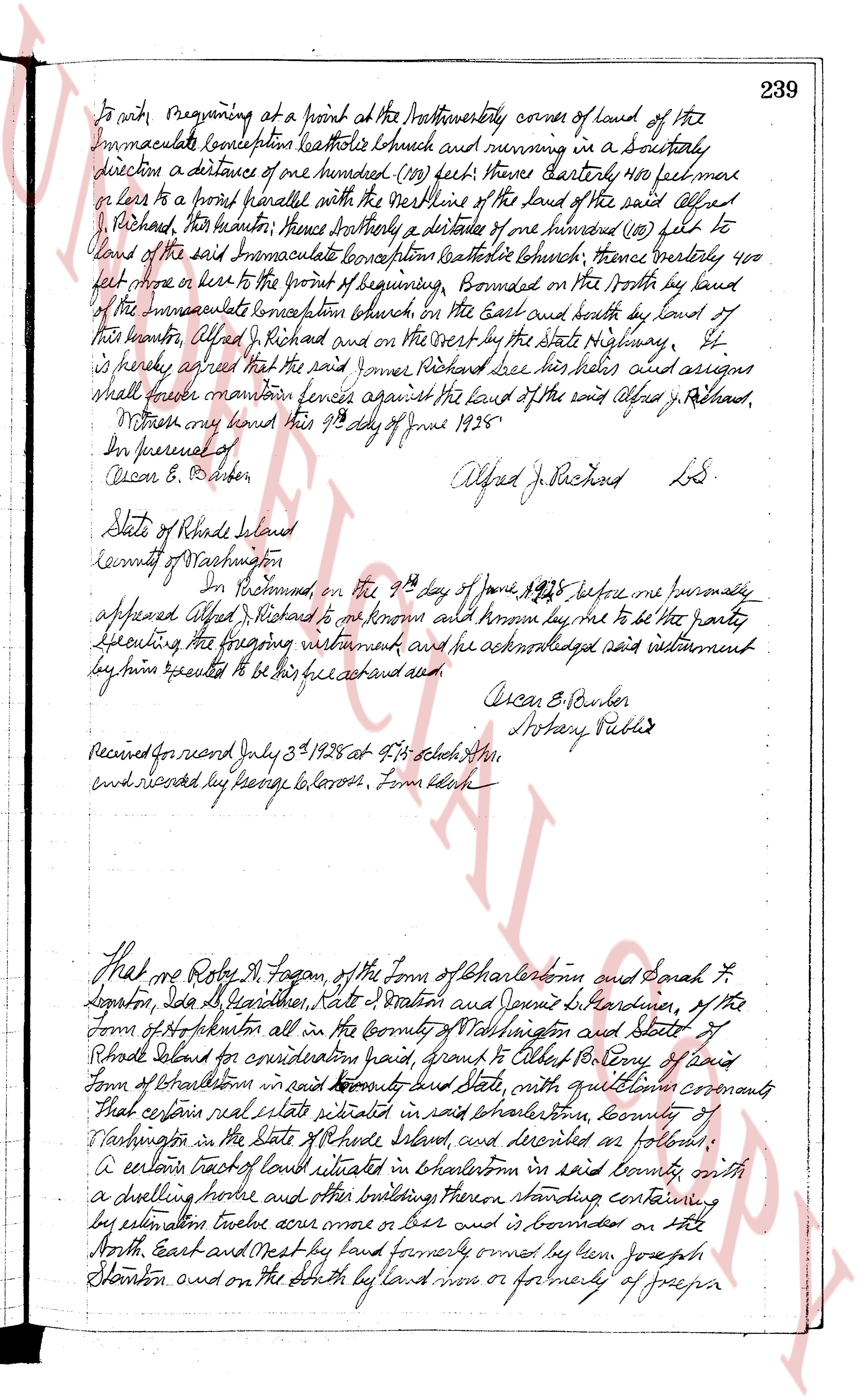
To wit: beginning at a point at the northwesterly corner of land of the
Immaculate Conception Catholic Church and running in a southerly
direction a distance of one hundred (100) feet thence easterly 400 feet more
or less to a point parallel with the rear line of the land of the said Alfred
J. Richard, thence southerly thence southerly a distance of one hundred (100) feet to
land of the said Immaculate Conception Catholic Church; thence westerly 400
feet more or less to the point of beginning. Bounded on the North by land
of the Immaculate Conception Church, on the East and South by land of
the grantor Alfred J. Richard and on the West by the State Highway.
It is hereby agreed that the said James Richard see his heirs and assigns
shall erect mountain fences against the land of the said Alfred J. Richard.
Witness my hand this 9th day of June 1938.
Per Journal of
Oscar B. Barber
Alfred J. Richard LdS.
State of Rhode Island
County of Washington
Ss.
In Providence, on the 9th day of June 1938 before me personally
appeared Alfred J. Richard to me known and known by me to be the party
executing the foregoing instrument and he acknowledged said instrument
by him signed to be his free act and deed
Oscar B. Barber
Notary Public
Received for record July 5th 1938 at 4:15 o'clock this
and recorded by George G. Cross. From Clerk
That we Roby H. Fagan, of the Town of Charlestown and Sarah L.
Legion, Ida G. Gardner, Kate S. Stanton and Dennis S. Gardner, of the
Town of Hopkinton all in the County of Washington and State of
Rhode Island for consideration paid, grant and convey to Robert Perry of said
Town of Charlestown in said County and State, with quitclaim covenants
that certain real estate situated in said Charlestown, County of
Washington in the State of Rhode Island, and described as follows:
A certain tract of land situate in Charlestown in said county with
a dwelling house and other buildings thereon standing containing
by estimation twelve acres more or less and is bounded on the
North, East and West by land formerly owned by him Joseph
Stanton and on the South by land now or formerly of George pa
page 2
240
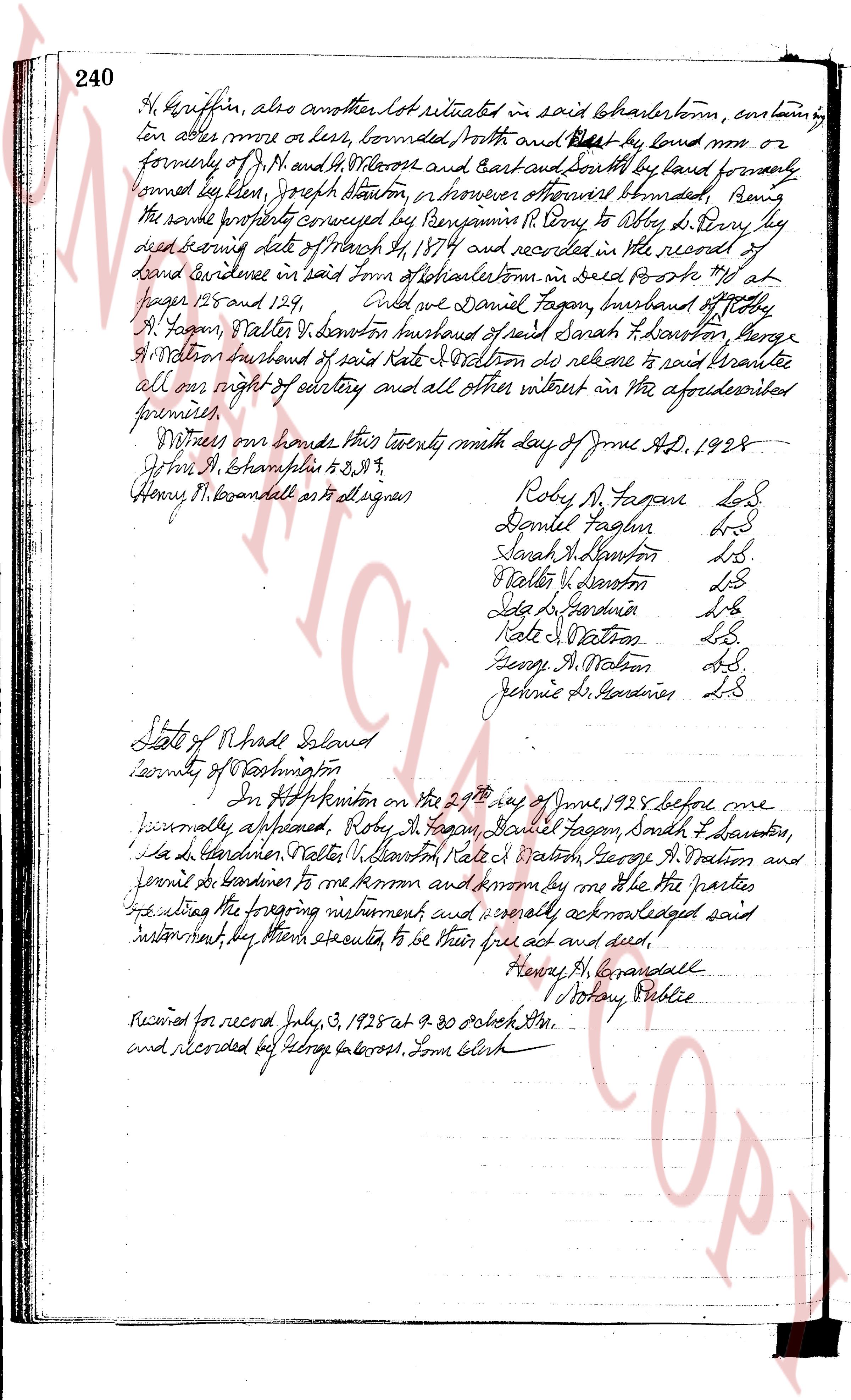
M. Griffin, also another lot situated in said Charlestown, containing
ten acres more or less, bounded North and West by land now or
formerly of J. H. and H. W. Cross and East and South by land formerly
owned by lee hixon, Joseph stanton, in manner otherwise described, being
the same property conveyed by Benjamin P. own to Obadiah L. Perry his
heirs lettering date of March 4, 1874 and recorded in the record of
land evidence in said town of Charlestown in said book No 4 at
pages 125 and 129.
said we Daniel Fagan, husband of Betty
A. Fagan, Walter L. Dexter husband of said Sarah H. Dexterton, George
A. Watson husband of said Kate J. Watson do release to said grantees
all our right of entry and all other interest in the aforesaid
premises.
Witness our hands this twenty ninth day of June AD. 1928
John M. Shampelton to S.W.T.
Henry H. Everandell att signer
Roby A. Fagan L.S.
Daniel Fagan L.S.
Sarah H. Dexterton L.S.
Walter L. Dexterton L.S.
Lydia L. Gardiner L.S.
Kate J. Watson L.S.
George A. Watson L.S.
Jennie L. Gardiner L.S.
State of Rhode Island
County of Washington
In West Kingston on the 29th day of June 1928 before me
personally appeared, Roby A. Fagan, Daniel Fagan, Sarah H. Dexterton,
Lydia L. Gardiner, Walter L. Dexterton, Kate J. Watson, George A. Watson and
Jennie L. Gardiner to me known and known by me the parties
had executing the foregoing instrument and severally acknowledged said
instrument, they then executed, to be their free act and deed.
Henry H. Everandell
Notary Public
Received for record July 3, 1928 at 9.30 o'clock AM.
and recorded by George Cross, Town Clerk.
page 3
Hartford Railroad Company do hereby certify that the foregoing is a true
copy of record, and in Testimony hereof I have hereunto set my hand and
affixed the seal of said Company this eleventh day of December, 1927,
A. E. Black, Secretary
Received for record May 14 1928 at 4:45 o'clock A.M.
and recorded by George Lawson, Town Clerk
Land now or formerly
John S. Hiscox
336 Rts Mon PC 1361+97.33
20" Pipe
Sta 455+58.58
Mon 1349+24.42
E = 0.15' Left
Area 5.45 Acres
Land of N.Y. N.H. & H. R.R. Co
Maintenance Center
Sta 1349 Sps
Township Line
Land now or formerly
John S. Hiscox
316 Rts
A MAP SHOWING A PORTION OF THE HARTFORD RAILROAD CO
RAIL ESTATE & RIGHT OF WAY FOR THE PROPOSED DEVELOPMENT
OF A NEW STATION TOWN P.I.
AND AS SURVEYED TO
SOUTH COUNTY PUBLIC SERVICE COMPANY
AUGUST 1928
Eugene M. Survey
V.S. Map No 6
4158
page 4
107
Land now or formerly
John S Hiscox
338.42' Mon PC 1361+97.33
To Providence
No. 1533+59.80'
Land now or formerly John S Hiscox
200.00'
Area 5.543 Acres
Mon 1349+24.42
$\pm$ 0.15' Left
Monumented Center Line
Land of N.Y. N.H. & H. R.R. Co.
Sta. 1433+63.63'
Land now or formerly
John S Hiscox
151.03'
To New London
Approved
(Signature)
Engineer of Surveys
THE NEW YORK NEW HAVEN & HARTFORD RAILROAD CO.
REAL ESTATE & RIGHT OF WAY DEPARTMENT
LAND IN CHARLESTOWN, R.I.
TO BE CONVEYED TO
SOUTH COUNTY PUBLIC SERVICE COMPANY
SCALE 1IN = 100FT AUGUST 1929
V.S. 36 5/8" Map B
SR15-B
page 5
107
Land now or formerly
John S Hiscox
338 ft
Mon PC 1361+97.33
To Providence
No 1533+59.80
Land now or formerly John S Hiscox
200.0'
Area 5.543 Acres
Mon 1349+24.42
$\pm$ 0.15 Left
Monumented Center Line
Land of N.Y. N.H. & H. R.R. Co.
Sta 1343+63.63
151.08
Land now or formerly
John S Hiscox
To New London
Approved
(Signature)
Engineer of Surveys
THE NEW YORK NEW HAVEN & HARTFORD RAILROAD CO.
REAL ESTATE & RIGHT OF WAY DEPARTMENT
LAND IN CHARLESTOWN, R.I.
TO BE CONVEYED TO
SOUTH COUNTY PUBLIC SERVICE COMPANY
SCALE 1IN = 100FT
AUGUST 1929
V.S. 36 5/8" Map B
SR15-B
page 6
107
Land now or formerly
John S Hiscox
338.42' Mon PC 1361+97.33
To Providence
No. 1533+59.80'
Land now or formerly John S Hiscox
200.00'
Area 5.543 Acres
Mon 1349+24.42
$\pm$ 0.15' Left
Monumented Center Line
Land of N.Y. N.H. & H. R.R. Co.
Sta. 1433+63.63'
To New London
Land now or formerly
John S Hiscox
151.03'
Approved
(Signature)
Engineer of Surveys
THE NEW YORK NEW HAVEN & HARTFORD RAILROAD CO.
REAL ESTATE & RIGHT OF WAY DEPARTMENT
LAND IN CHARLESTOWN, R.I.
TO BE CONVEYED TO
SOUTH COUNTY PUBLIC SERVICE COMPANY
SCALE 1" = 100 FEET
AUGUST 1929
V.S. 36 5/8" Map B
SR15-B
page 7
107
Land now or formerly
John S Hiscox
338 ft
Mon PC 1361+97.33
To Providence
No 1533+59.80
Land now or formerly John S Hiscox
200.0'
Area 5.543 Acres
Mon 1549+24.42
$\pm$ 0.15 Left
Monumented Center Line
Land of N.Y. N.H. & H. R.R. Co.
Sta 1543+65.63
To New London
Land now or formerly
John S Hiscox
151.08'
Approved
(Signature)
Engineer of Surveys
THE NEW YORK NEW HAVEN & HARTFORD RAILROAD CO.
REAL ESTATE & RIGHT OF WAY DEPARTMENT
LAND IN CHARLESTOWN, R.I.
TO BE CONVEYED TO
SOUTH COUNTY PUBLIC SERVICE COMPANY
SCALE 1IN = 100FT
AUGUST 1929
V.S. 36 5/8" Map B
SR15-B
page 8
107
Land now or formerly
John S Hiscox
338 feet
Mon PC 1361+97.33
To Providence
No 1533+59.80
Land now or formerly John S Hiscox
200.0'
Area 5.543 Acres
Mon 1549+24.42
$\pm$ 0.15 Left
Monumented Center Line
Land of N.Y. N.H. & H. R.R. Co.
Sta 1543+65.63
To New London
Land now or formerly
John S Hiscox
151.08
Approved
(Signature)
Engineer of Surveys
THE NEW YORK NEW HAVEN & HARTFORD RAILROAD CO.
REAL ESTATE & RIGHT OF WAY DEPARTMENT
LAND IN CHARLESTOWN, R.I.
TO BE CONVEYED TO
SOUTH COUNTY PUBLIC SERVICE COMPANY
SCALE 1IN = 100FT
AUGUST 1929
V.S. 36 5/8" Map B
SR15-B
page 9
107
Land now or formerly
John S Hiscox
338.42' Mon PC 1361+97.33
To Providence
No. 1533+59.80'
Land now or formerly John S Hiscox
200.00'
Area 5.543 Acres
Mon 1349+24.42
$\pm$ 0.15' Left
Monumented Center Line
Land of N.Y. N.H. & H. R.R. Co.
Sta. 1433+68.63'
To New London
Land now or formerly
John S Hiscox
151.03'
Approved
(Signature)
Engineer of Surveys
THE NEW YORK NYH & H. HARFORD RAILROAD CO.
REAL ESTATE & RIGHT OF WAY DEPARTMENT
LAND IN CHARLESTOWN, R.I.
TO BE CONVEYED TO
SOUTH COUNTY PUBLIC SERVICE COMPANY
SCALE 1" = 100 FEET AUGUST 1929
V.S. 36 3/4° Map B
SR15-B
page 10
107
Land now or formerly
John S Hiscox
338 feet
Mon PC 1361+97.33
To Providence
No 1533+59.80
Land now or formerly John S Hiscox
200.0'
Area 5.543 Acres
Mon 1549+24.42
$\pm$ 0.15 Left
Monumented Center Line
Land of N.Y. N.H. & H. R.R. Co.
Sta 1543+65.63
To New London
Land now or formerly
John S Hiscox
151.08
Approved
(Signature)
Engineer of Surveys
THE NEW YORK NYH & H. HARFORD RAILROAD CO.
REAL ESTATE & RIGHT OF WAY DEPARTMENT
LAND IN CHARLESTOWN, R.I.
TO BE CONVEYED TO
SOUTH COUNTY PUBLIC SERVICE COMPANY
SCALE 1IN = 100FT
AUGUST 1929
V.S. 36 5/8" Map B
SR15-B
page 11
107
Land now or formerly
John S Hiscox
338 ft
Mon PC 1361+97.33
To Providence
No 1533+59.80
Land now or formerly John S Hiscox
200.0'
Area 5.543 Acres
Mon 1549+24.42
$\pm$ 0.15 Left
Monumented Center Line
Land of N.Y. N.H. & H. R.R. Co.
Sta 1543+65.63
To New London
Land now or formerly
John S Hiscox
151.08'
Approved
(Signature)
Engineer of Surveys
THE NEW YORK NYH & H. HARFORD RAILROAD CO.
REAL ESTATE & RIGHT OF WAY DEPARTMENT
LAND IN CHARLESTOWN, R.I.
TO BE CONVEYED TO
SOUTH COUNTY PUBLIC SERVICE COMPANY
SCALE 1IN = 100FT
AUGUST 1929
V.S. 36 5/8" Map B
SR15-B
The page as recorded