The Deed Walker · From Ninigret · Charlestown, Rhode Island land evidence, 1738 to today
Trail: 49@28/665 › 8129 › 82@27/289

3/26/1938 · DEED · book 27 page 289 doc 82@27/289

From KENYON FRED H life, KENYON MAUDE B
To WESTON GEORGE W life, WESTON HAZEL I, GAVITT HANNAH A life, GAVITT GEORGE E life
Premises land shown on a plan dated November 1st 1937 (Charlestown, Wood River Junction)
Index description SEE DOC

Back — where this land came from

unknown book 27 p 272 Charlestown
“said plat being recorded in the Records of Land to situate in the town of Charlestown, Book No. 27, at Page 272”
◀ Follow back 1938 · DEED · KENYON FRED H; KENYON MAUDE B → GARDINER EDNA M; GARDINER WILLIAM J · book 27 p 272
read by: gemma

The grantor's earlier acquisitions, by name — the man, not necessarily this land

◀ 1938 · DEED · GARDINER EDNA M; GARDINER WILLIAM J → KENYON FRED H · book 27 p 271
◀ 1938 · DEED · KENYON FRED H; KENYON MAUDE B → KENYON MAUDE B; KENYON FRED H · book 27 p 322
◀ 1938 · DEED · KING CHARLES; KING MARIE LEA → KENYON FRED H · book 27 p 393
◀ 1938 · DEED · DYSON CHARLES H; DYSON HAZEL H → KENYON FRED H · book 27 p 393
◀ 1935 · DEED · TUCKER MILLARD F → POTTER MYRA; KENYON FRED H; KENYON MAUDE B; POTTER HAROLD · book 26 p 49
◀ 1926 · DEED · BURDICK MARION G; BURDICK EDWARD E → KENYON FRED H; KENYON MAUDE B · book 22 p 357
◀ 1910 · DEED · KENYON FRANK I; KENYON LOUISE C → KENYON FRED H · book 16 p 430
◀ 1910 · DEED · KENYON REBA V BY GUARDIAN → KENYON FRED H · book 16 p 439

Forward — where this land went

Follow forward ▶ 1938 · MORTGAGE · WESTON HAZEL I; GAVITT HANNAH A; GAVITT GEORGE E; WESTON GEORGE → WESTERLY LUMBER COMPANY · book 27 p 303
“conveyed to us by Fred N. Kenyon by deed dated March 23, 1938”
cites this instrument as its source · read by gemma
Follow forward ▶ 1938 · MORTGAGE DISCHARGE · WESTERLY LUMBER COMPANY → GAVITT HANNAH A; GAVITT GEORGE E; WESTON GEORGE; WESTON HAZEL I · book 27 p 303
“conveyed to us by Fred N. Kenyon by deed dated March 23, 1936”
cites this instrument as its source · read by gemma

The grantee's later conveyances, by name — the man, not necessarily this land; the one that cites this deed as its source is the land

▶ 1939 · DEED · GAVITT HANNAH A → WESTON GEORGE W; WESTON HAZEL I · book 28 p 118
▶ 1941 · DEED · GAVITT GEORGE W → LARKIN CHARLES M · book 28 p 428
▶ 1938 · MORTGAGE · WESTON HAZEL I; GAVITT HANNAH A; GAVITT GEORGE E; WESTON GEORGE → WESTERLY LUMBER COMPANY · book 27 p 303
▶ 1938 · MORTGAGE · WESTON GEORGE W; WESTON HAZEL I; GAVITT HANNAH A; GAVITT GEORGE E → FIRST FEDERAL SAVINGS AND LOAN ASSOCIATION OF PROVIDENCE · book 27 p 411
▶ 1940 · MORTGAGE · WESTON HAZEL I; WESTON GEORGE T → FIRST FEDERAL SAVINGS AND LOAN ASSOCIATION OF PROVIDENCE · book 28 p 209
▶ 1943 · DEED · WESTON GEORGE W; WESTON HAZEL I → MINAKIN EMILY R; MINAKIN FRANK · book 29 p 146

The instrument's own words

page 1
289 I, FRED H. KENYON, of the Town of Charlestown, County of Washington, State of Rhode Island, for consideration paid, grant to GEORGE W. WESTON and HAZEL N. WESTON, (husband and wife) GEORGE E. GAVITT and HANNAH A. GAVITT, (husband and wife) all of the Town of Richmond, County of Washington, State of Rhode Island, and to the survivor of them, and unto the heirs and assigns of said survivor, with rights of survivorship, as joint tenants and not as ten- ants in common, with WARRANTY CONVEYANCE That certain real estate situate in the town of Charlestown, County of Washington, State of Rhode Island, characterized, and described as follows: Beginning at Point A on the northerly side of the State highway leading from the Village of Charlestown to Wood River Junction said point being Two Hundred Ninety (290) feet east of a stone bound set in the ground at the north- westerly corner of the premises of Julian J. Gardner, sit ut hence running northerly, in a line of bearing North 15 degrees East, Two Hundred (200) feet distant from parcel and to the boundary line intersecting to said Gardner land, a distance of Three Hundred and Fifty (350) feet, then running easterly, bearing a distance of One Hundred Twenty-five (125) feet hence turning at right angles and running southerly, in a line of bearing South 15 degrees East, or less, to the said State Highway; thence turning and running westerly, bounded southerly by said highway in a line of One Hundred Twenty-five (125) feet to the point and place of beginning. Meaning and intending to hereby convey the land shown on a plan dated November 1st 1937 of a portion of the Town of Charlestown - from Fred H. Kenyon land, by G. F. Kenyon v. J. J. Gardner; said plat being recorded in the Records of Land to situate in the town of Charlestown, Book No. 27, at Page 272; reference to said plat being hereby had and made and the same is made a part hereof. I, MAUDE B. KENYON, wife of the grantor release to said grantees all my right of dower and all other interest in the aforesaid premises. WITNESS our hands this 23rd day of March, A. D. 1938. FRED H. KENYON MAUDE B. KENYON (INTERNAL REVENUE STAMP, 50c) STATE OF RHODE ISLAND) County of Washington ) In Charlestown on the 23rd day of March, A. D. 1938, before me personally appeared Fred H. Kenyon and Maude B. Kenyon, husband and wife, both to me known and known by me to be the parties executing the foregoing instrument, and they acknowledged said instrument, by them executed, to be their free act and deed. LINTON L. BROWN Notary Public. Received for record March 26th, A. D. 1938 at 1:55 o'clock, p. m., and recorded by [Signature] Town Clerk

The page as recorded
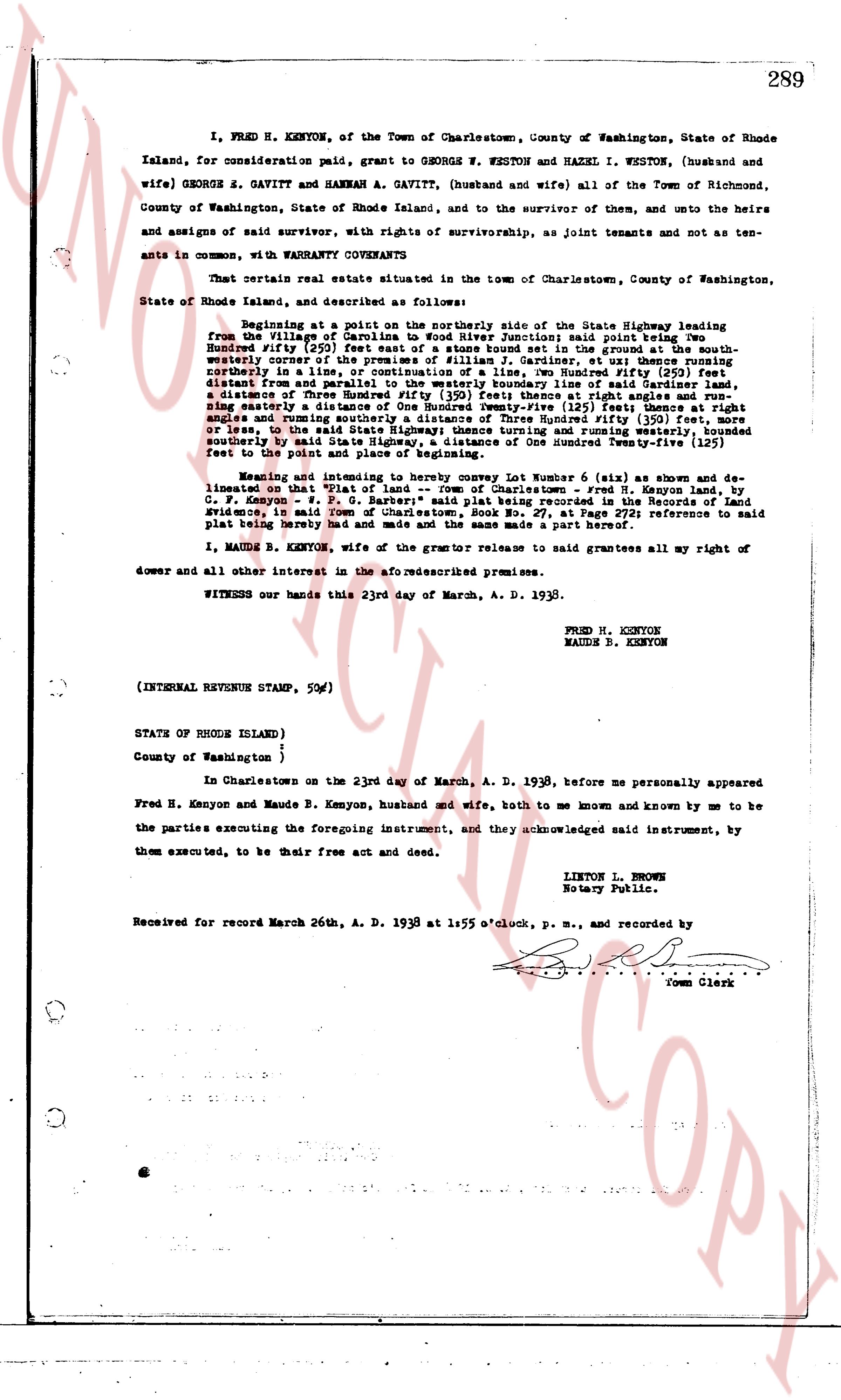
page 1

deed_walker_v1.9_2026-10-10 · the index is the town's own (i2l.uslandrecords.com); transcripts, chains and the assessor's cards are the Perry Machine's reading of it. Where the record we hold runs out, the page says so.