The instrument's own words
page 1
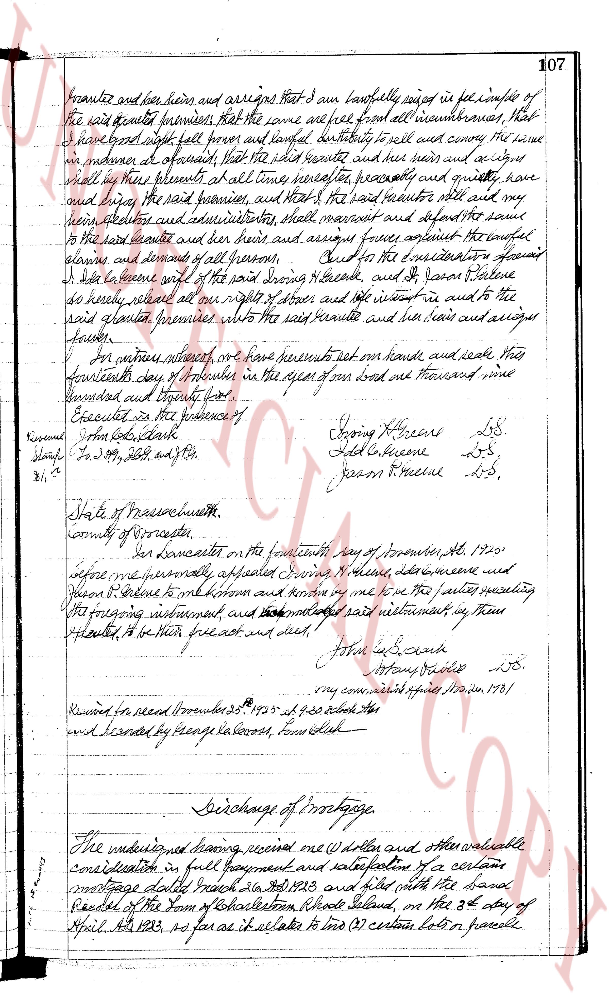
grantee and her heirs and assigns that I am lawfully seized in fee simple of
the said granted premises; that the same are free from all incumbrances, that
I have good right, full power and lawful authority to sell and convey the same
in manner as aforesaid; that the said grantee and her heirs and assigns shall
hold by these presents at all times hereafter, peaceably and quietly, have
and enjoy the said premises, and that the said grantor shall warrant and will
her heirs, executors and administrators, shall warrant and defend the same
to the said grantee and her heirs and assigns forever against the lawful
claims and demands of all persons. And for the consideration aforesaid
I do hereby grant, remise, release and forever alienate, and to Jason Greene
do hereby release all our right of seizure and title interest in and to the
said granted premises unto the said grantee and her heirs and assigns
forever.
In witness whereof, we have hereunto set our hands and seals this
fourteenth day of November in the year of our Lord one thousand nine
hundred and twenty five.
Executed in the presence of
Rowena S. Day, Clerk
Stamps $1.25, 25c, 25c, and 25c.
2.1/4
State of Massachusetts
County of Worcester
On Lancaster on the fourteenth day of November, AD 1925
before me personally appeared Irving M. Greene, Lela G. Greene and
Jason R. Greene to me known to be the parties executing
the foregoing instrument and acknowledged said instrument as their
free act to be his free act and deed.
John S. Day
Notary Public LS.
my commission expires Nov 30, 1931
Received for record November 25th 1925 at 9.30 o'clock AM
and recorded by George LaRocco, Town Clerk
Discharge of mortgage.
The undersigned having received one (1) dollar and other valuable
consideration in full payment and satisfaction of a certain
mortgage dated March 26th AD 1923 and filed with the town
Records of the town of Charlestown, Rhode Island, on the 3d day of
April AD 1923, so far as it relates to two (2) certain lots or parcels
page 2
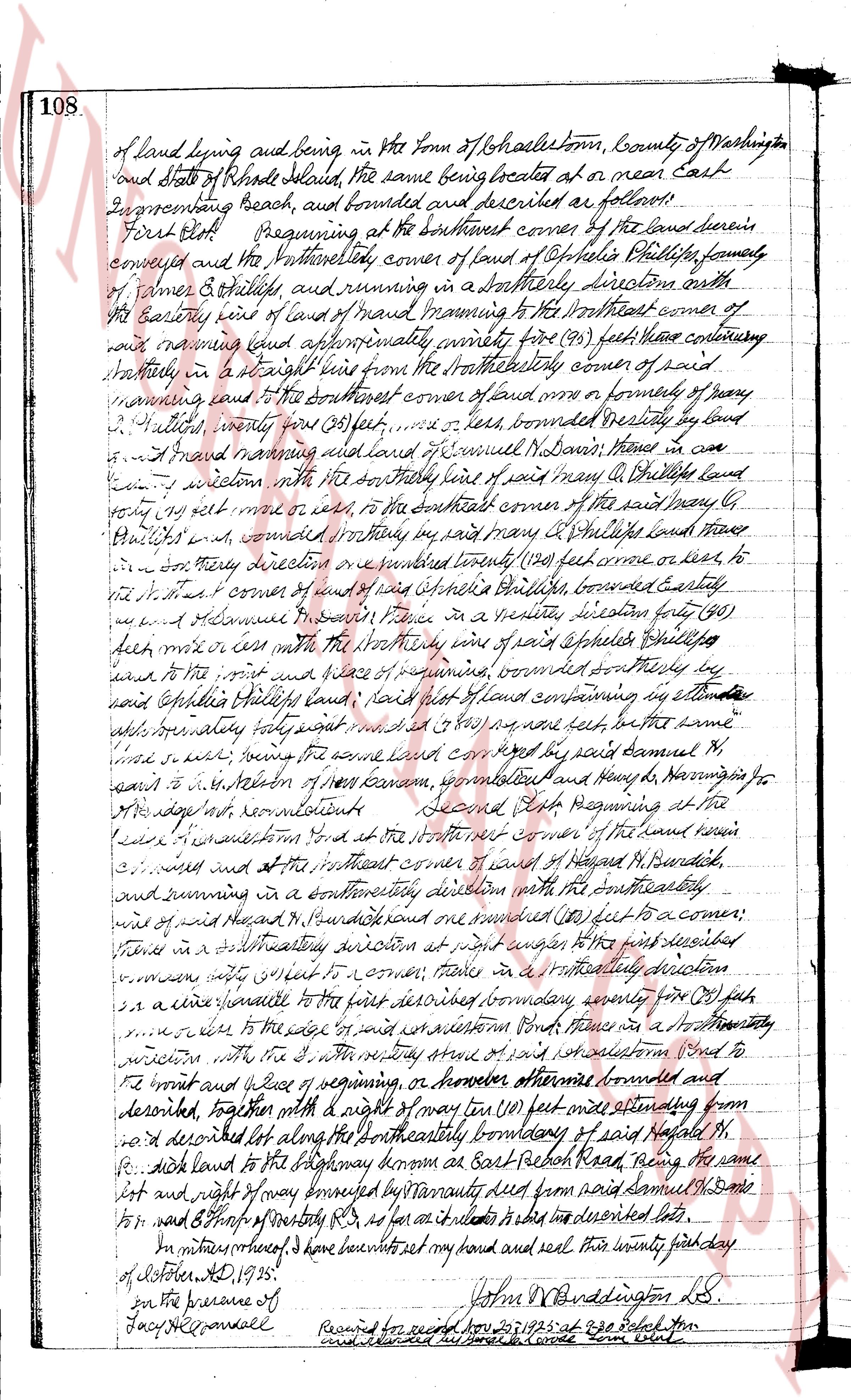
108 of land lying and being in the Town of Charlestown, County of Washington
and state of Rhode Island, the same being situated at or near East
Greencombang Beach, and bounded and described as follows:
First Plot Beginning at the southwest corner of the land there in
conveyed and the Northwest corner of land of Stephen Phillips formerly
of James S. Phillips, and running in a southeasterly direction north
of the Easterly line of land of Israel Manning to the Northeast corner of
said Manning and running approximately ninety five (95) feet hence continuing
southeasterly in a straight line from the northeasterly corner of said
Manning to the Northeast corner of land ozn or owner of property
2. Phillips, ninety one (91) feet, or less, bounded westerly by land
of Israel Manning and land of Samuel Nathan, those in a
line in common with the southeasterly line of said many Mr Phillips land
property set more or less to the southeast corner of the said property
2. Phillips's land, bounded easterly in a straight line forty (40) feet land those
in a southeasterly direction or a parallel twenty (20) feet more or less to
the N E corner of land of Stephen Phillips, bounded easterly
by land of Alonace in west place in a parallel distance forty (40)
feet more or less with the southeasterly line of said Stephen Phillips
to the point and place of beginning, bounded northeasterly by
said Stephen Phillips land, said first plot of land containing by estimate
about twenty four feet square or so near some feet in the same
lined so marked, being the same land conveyed by said Samuel N.
barns to J. M. Stebbins of New Canaan, Connecticut and Henry W. Harrington for
their separate and concurrents
Second Plot Beginning at the
line of the westernmost road at the North West corner of land of Hagadah M. Bernardick,
continued and at the Southwest corner of land of Hagadah M. Bernardick,
and running in a southeasterly direction with the southeasterly
line of said H. Bernardick and continued one hundred (100) feet to a corner;
thence in a southeasterly direction at right angles to the first described
line to a corner; thence in a southeasterly direction
one hundred (100) feet to a corner; thence in a southeasterly direction
one hundred (100) feet to a corner; then in a southeasterly
direction to the edge of said west road one hundred (100) feet to
the point and place of beginning, or however otherwise bounded and
described, together with a right of way ten (10) feet wide extending from
said described lot along the northeasterly boundary of said Hagadah M.
Bernardick land to the highway known as East Beach Road, naming the same
lot and right of way bounded by boundary line from said Samuel N. Barns
to p. and s. Thoro of southeasterly Rd, as far as it relates to said described lot.
In witness whereof I have set my bond and seal this twenty fifth day
of October A.D. 1935. [Signature] John W. Burrington L.S.
In the presence of
[Signature] Fayne R. Randall
Recorded for record Oct 25 1935 at 8 pg’s’’’’’’’’’’’’’’’’’’’’’’’’’’’’’’’’’’’’’’’’’’’’’’’’’’’’’’’’’’’’’’’’’’’’’’’’’’’’’’’’’’’’’’’’’’’’’’’’’’’’’’’’’’’’’’’’’’’’’’’’’’’’’’’’’’’’’’’’’’’’’’’’’’’’’’’’’’’’’’’’’’’’’’’’’’’’’’’’’’’’’’’’’’’’’’’’’’’’’’’’’’’’’’’’’’’’’’’’’’’’’’’’’’’’’’’’’’’’’’’’’’’’’’’’’’’’’’’’’’’’’’’’’’’’’’’’’’’’’’’’’’’’’’’’’’’’’’’’’’’’’’’’’’’’’’’’’’’’’’’’’’’’’’’’’’’’’’’’’’’’’’’’’’’’’’’’’’’’’’’’’’’’’’’’’’’’’’’’’’’’’’’’’’’’’’’’’’’’’’’’’’’’’’’’’’’’’’’’’’’’’’’’’’’’’’’’’’’’’’’’’’’’’’’’’’’’’’’’’’’’’’’’’’’’’’’’’’’’’’’’’’’’’’’’’’’’’’’’’’’’’’’’’’’’’’’’’’’’’’’’’’’’’’’’’’’’’’’’’’’’’’’’’’’’’’’’’’’’’’’’’’’’’’’’’’’’’’’’’’’’’’’’’’’’’’’’’’’’’’’’’’’’’’’’’’’’’’’’’’’’’’’’’’’’’’’’’’’’’’’’’’’’’’’’’’’’’’’’’’’’’’’’’’’’’’’’’’’’’’’’’’’’’’’’’’’’’’’’’’’’’’’’’’’’’’’’’’’’’’’’’’’’’’’’’’’’’’’’’’’’’’’’’’’’’’’’’’’’’’’’’’’’’’’’’’’’’’’’’’’’’’’’’’’’’’’’’’’’’’’’’’’’’’’’’’’’’’’’’’’’’’’’’’’’’’’’’’’’’’’’’’’’’’’’’’’’’’’’’’’’’’’’’’’’’’’’’’’’’’’’’’’’’’’’’’’’’’’’’’’’’’’’’’’’’’’’’’’’’’’’’’’’’’’’’’’’’’’’’’’’’’’’’’’’’’’’’’’’’’’’’’’’’’’’’’’’’’’’’’’’’’’’’’’’’’’’’’’’’’’’’’’’’’’’’’’’’’’’’’’’’’’’’’’’’’’’’’’’’’’’’’’’’’’’’’’’’’’’’’’’’’’’’’’’’’’’’’’’’’’’’’’’’’’’’’’’’’’’’’’’’’’’’’’’’’’’’’’’’’’’’’’’’’’’’’’’’’’’’’’’’’’’’’’’’’’’’’’’’’’’’’’’’’’’’’’’’’’’’’’’’’’’’’’’’’’’’’’’’’’’’’’’’’’’’’’’’’’’’’’’’’’’’’’’’’’’’’’’’’’’’’’’’’’’’’’’’’’’’’’’’’’’’’’’’’’’’’’’’’’’’’’’’’’’’’’’’’’’’’’’’’’’’’’’’’’’’’’’’’’’’’’’’’’’’’’’’’’’’’’’’’’’’’’’’’’’’’’’’’’’’’’’’’’’’’’’’’’’’’’’’’’’’’’’’’’’’’’’’’’’’’’’’’’’’’’’’’’’’’’’’’’’’’’’’’’’’’’’’’’’’’’’’’’’’’’’’’’’’’’’’’’’’’’’’’’’’’’’’’’’’’’’’’’’’’’’’’’’’’’’’’’’’’’’’’’’’’’’’’’’’’’’’’’’’’’’’’’’’’’’’’’’’’’’’’’’’’’’’’’’’’’’’’’’’’’’’’’’’’’’’’’’’’’’’’’’’’’’’’’’’’’’’’’’’’’’’’’’’’’’’’’’’’’’’’’’’’’’’’’’’’’’’’’’’’’’’’’’’’’’’’’’’’’’’’’’’’’’’’’’’’’’’’’’’’’’’’’’’’’’’’’’’’’’’’’’’’’’’’’’’’’’’’’’’’’’’’’’’’’’’’’’’’’’’’’’’’’’’’’’’’’’’’’’’’’’’’’’’’’’’’’’’’’’’’’’’’’’’’’’’’’’’’’’’’’’’’’’’’’’’’’’’’’’’’’’’’’’’’’’’’’’’’’’’’’’’’’’’’’’’’’’’’’’’’’’’’’’’’’’’’’’’’’’’’’’’’’’’’’’’’’’’’’’’’’’’’’’’’’’’’’’’’’’’’’’’’’’’’’’’’’’’’’’’’’’’’’’’’’’’’’’’’’’’’’’’’’’’’’’’’’’’’’’’’’’’’’’’’’’’’’’’’’’’’’’’’’’’’’’’’’’’’’’’’’’’’’’’’’’’’’’’’’’’’’’’’’’’’’’’’’’’’’’’’’’’’’’’’’’’’’’’’’’’’’’’’’’’’’’’’’’’’’’’’’’’’’’’’’’’’’’’’’’’’’’’’’’’’’’’’’’’’’’’’’’’’’’’’’’’’’’’’’’’’’’’’’’’’’’’’’’’’’’’’’’’’’’’’’’’’’’’’’’’’’’’’’’’’’’’’’’’’’’’’’’’’’’’’’’’’’’’’’’’’’’’’’’’’’’’’’’’’’’’’’’’’’’’’’’’’’’’’’’’’’’’’’’’’’’’’’’’’’’’’’’’’’’’’’’’’’’’’’’’’’’’’’’’’’’’’’’’’’’’’’’’’’’’’’’’’’’’’’’’’’’’’’’’’’’’’’’’’’’’’’’’’’’’’’’’’’’’’’’’’’’’’’’’’’’’’’’’’’’’’’’’’’’’’’’’’’’’’’’
The page as recorded