The instrument's own words
Attribution under review. The portal's file number is shared by more than one instrument, and the words below could not be placed with certainty on this one by their own evidence (page stamp, parties, dates); they may belong to a neighbouring instrument. Read them as the record of the page, not yet as this deed's own.
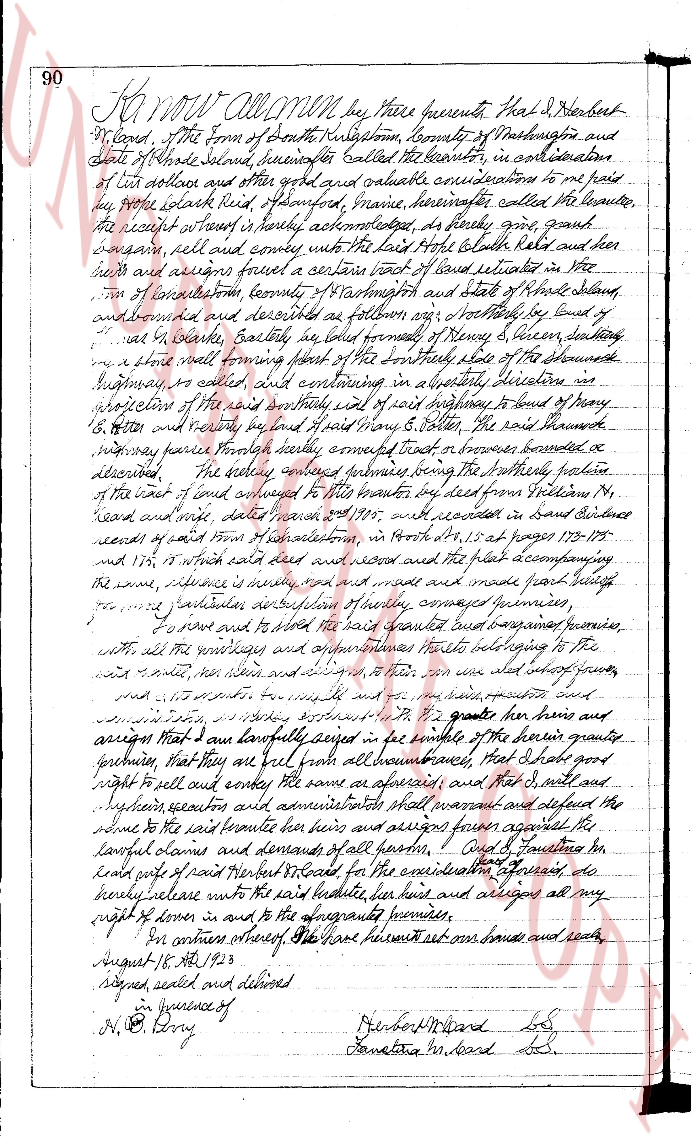
page 1
90 Know ALL MEN by these presents, that I, Herbert
McCard, of the Town of South Kingstown, county of Washington and
State of Rhode Island, hereinafter called the grantor, in consideration
of ten dollars and other good and valuable considerations to me paid
by Philip Stark Reid, of Sanford, Maine, hereinafter called the grantee,
the receipt whereof is hereby acknowledged, do hereby grant,
bargain, sell and convey unto the said Philip Stark Reid and his
heirs and assigns forever a certain tract of land situated in the
Town of Southkingstown, county of Washington and State of Rhode Island,
and bounded and described as follows: viz: northerly by land of
James W. Clarke, Eastly, by line formed formerly of Henry S. Dixon, settling
on a shore wall forming part of the northerly side of the chamado
Highway, so called, and continuing in a westerly direction in
intersection of the said northerly line of said highway to bound of Mary
E. Eaton and westerly by land of Mary E. Eaton, the said chamado
highway forming southerly boundary thereof, southerly bounded as
described. The hereby conveyed premises being the northerly portion
of the east half of land conveyed to this grantor by deed from William M.
McCard and wife, dated March 23rd 1905, and recorded in said Evidence
records of said Town of Southkingstown, in volume 14, page 173-175
and 175, to which said deed and record and the plat accompanying
the same, reference is hereby made, and made part hereof hereby
for more particular description of hereby conveyed premises.
To have and to hold the said granted bargain and sold premises
with all the wreckage and improvements thereto belonging to the
said grantee, her heirs and assigns, to their use and benefit forever,
and I, the grantor, for myself and my heirs, executors, administrators
and assigns, do hereby covenant to the grantee her heirs and
assigns that I and lawfully seized in fee simple of the herein granted
premises, that they are free from all encumbrances, that I shall have
right to sell and convey the same as aforesaid, and that I, my heirs and
their successors and administrators shall warrant and defend the
title to the said grantee her heirs and assigns against any and all
lawful claims and demands of all persons. And I, Samantha Mc
Card wife of said Herbert McCard for the consideration aforesaid, do
hereby release unto the said grantee, her heirs and assigns all my
right of dower in and to the aforesaid premises.
In witness whereof we have hereunto set our hands and seals
August 18th AD 1923
Signed, sealed and delivered
in presence of
H. O. Perry
Herbert McCard L.S.
Samantha McCard L.S.
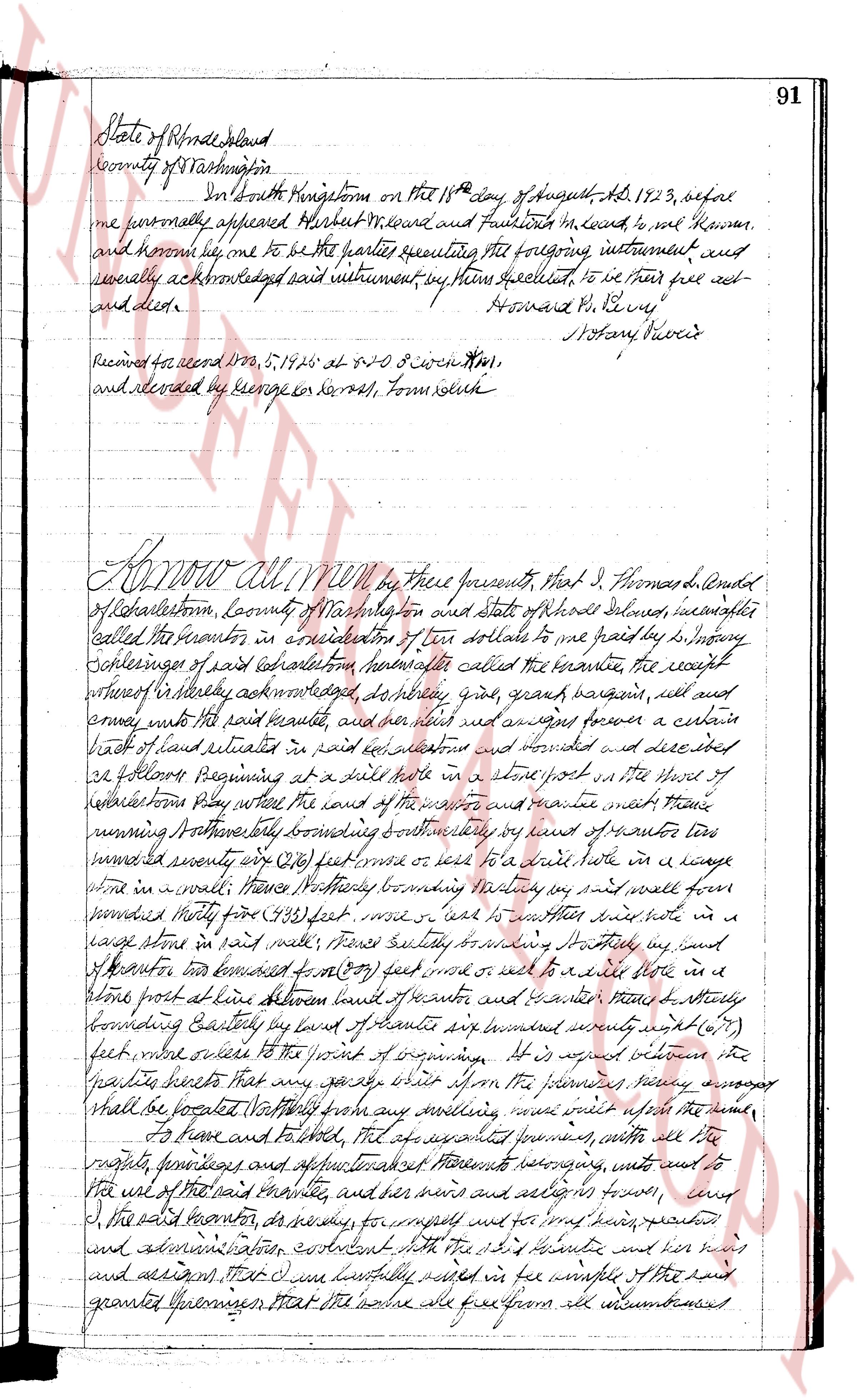
page 2
State of Rhode Island
County of Washington
In South Kingstown on the 18th day of August AD 1823, before
me personally appeared Herbert M. Board and Fairbank M. Board to me known
and known me to be one of the parties executing the foregoing instrument and
severally acknowledged said instrument by them sealed set to be their free act
and deed.
Howard P. Perry
Notary Public
Received for record 1823, 5.19 p.m at $1.50 C witness #1.
and recorded by George G. Nash, Tom clerk
Know all MEN by these presents, That I, Thomas L. Arnold
of Narragansett, County of Washington and State of Rhode Island aforesaid, hereafter
called the grantor in consideration of ten dollars to me paid by Dr. Sidney
Schreiner of said jurisdiction hereafter called the grantee the receipt
whereof I hereby acknowledge, do hereby give, grant bargain sell and
convey unto the said grantee and his heirs and assigns forever a certain
piece of land situated in said jurisdiction bounded and described and devised as
follows Beginning at a spike hole in a stone post in the house of
Narragansett Ply where the road of the west side and east side meet thence
running Northwesterly by bounding southwesterly by said road thence
running southeasterly about 200 feet or there on to a stake note in a lineage
stone in a wall thence Northwesterly bounding northeasterly by said wall then
running southeasterly from 143 feet more or less to another stake note in a
large stone in said wall thence southerly bounding southeasterly by said wall
of stones thence northwest from 200 feet more or less to a spike hole in a
stone post distance between bounds of stones and grantor thence Northwesterly
bounding easterly by land of stones about seventy seven (77)
feet more or less to the point of beginning. It is agreed between the
granting parties that any species shrubbery upon the premises namely asparagus
that be planted Northwesterly by any means will not stop the grantee
to prune and to lopped, the aforesaid premises with all the lots
rights privileges and appurtenances thereunto belonging ways water and
the use of the said pasture together with her heirs and assigns forever, and
I the said grantor do hereby warrant and for myself and for my heirs executors
and administrators convenient with the said grantee and his heirs
and assigns, that I and my lawfully heirs will be full warranty of the said
granted premises that the same are free from all encumbrances
The page as recorded