The instrument's own words
page 1 · read by Gemma vision
655
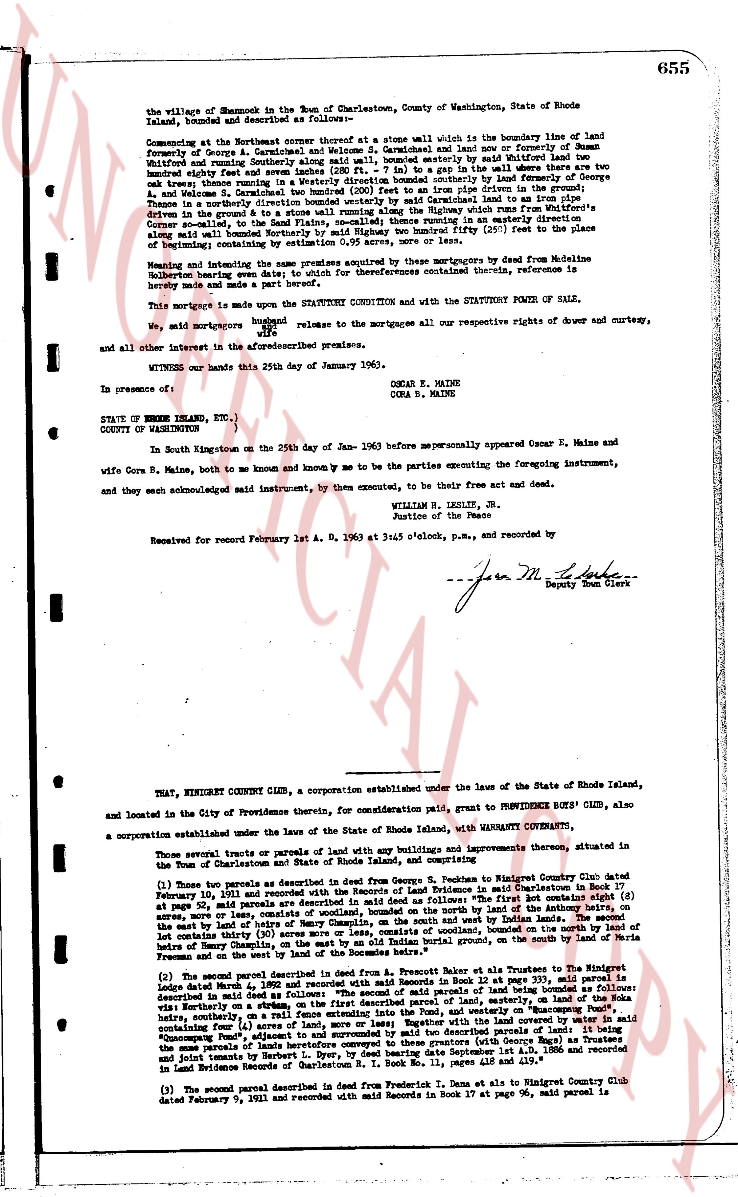
the village of Shannock in the Town of Charlestown, County of Washington, State of Rhode Island, bounded and described as follows:
Commencing at the Northwest corner thereof at a stone wall which is the boundary line of land formerly of George A. Carmichael and welcome S. Carmichael and land now or formerly of Suman Whitford and running Southerly along said wall, bounded easterly by a stone wall where there are two oak trees; thence running in a Westerly direction bounded southerly by land formerly of George A. and Welcome S. Carmichael; thence running in a Northerly direction free size fifty feet to the Place of Beginning; thence in a northerly direction bounded westerly by said Carmichael land to an iron pipe driven in the ground & to a stone wall running North West by North to the boundary line of the Higgins' Corner road leading to the village of Shannock; thence running in an easterly direction along said wall bounded Northerly by said Highway two hundred fifty (250) feet to the place of beginning containing one acre of land more or less.
Meaning and intending the same premises acquired by their mortgagees by deed from Madeline Holbern bearing even date with or before their references contained herein, reference is hereby made to said deed for further description.
This mortgage is made upon the STATUTORY CONDITION and with the STATUTORY FORM OF SALE.
We, aid mortgagors husband and wife release to the mortgagees all our respective rights of dower and curtesy, wife
and all other interest in the aforementioned premises.
WITNESS our hands this 25th day of January 1963.
OSCAR E. MAINE
CORA B. MAINE
In presence of:
STATE OF RHODE ISLAND, ETC.)
COUNTY OF WASHINGTON )
In South Kingstown on the 25th day of Jan- 1963 before me personally appeared Oscar E. Maine and wife Cora B. Maine, both of me known and known me to be the parties executing the foregoing instrument, and they each acknowledged said instrument, by them executed, to be their free act and deed.
WILLIAM H. LESLIE, JR.
Justice of the Peace
Received for record February 1st A. D. 1963 at 3:45 o'clock, p.m., and recorded by
- - - - - - - - - - - - - - - - - - - - - - - - - - - - - - - - - - - - - - - - - - - - - - - - - - - - - - - - - - - - - - - - - - - - - - - - - - - - - - - - - - - - - - - - - - - - - - - - - - - - - - - - - - - - - - - - - - - - - - - - - - - - - - - - - - - - - - - - - - - - - - - - - - - - - - - - - - - - - - - - - - - - - - - - - - - - - - - - - - - - - - - - - - - - - - - - - - - - - - - - - - - - - - - - - - - - - - - - - - - - - - - - - - - - - - - - - - - - - - - - - - - - - - - - - - - - - - - - - - - - - - - - - - - - - - - - - - - - - - - - - - - - - - - - - - - - - - - - - - - - - - - - - - - - - - - - - - - - - - - - - - - - - - - - - - - - - - - - - - - - - - - - - - - - - - - - - - - - - - - - - - - - - - - - - - - - - - - - - - - - - - - - - - - - - - - - - - - - - - - - - - - - - - - - - - - - - - - - - - - - - - - - - - - - - - - - - - - - - - - - - - - - - - - - - - - - - - - - - - - - - - - - - - - - - - - - - - - - - - - - - - - - - - - - - - - - - - - - - - - - - - - - - - - - - - - - - - - - - - - - - - - - - - - - - - - - - - - - - - - - - - - - - - - - - - - - - - - - - - - - - - - - - - - - - - - - - - - - - - - - - - - - - - - - - - - - - - - - - - - - - - - - - - - - - - - - - - - - - - - - - - - - - - - - - - - - - - - - - - - - - - - - - - - - - - - - - - - - - - - - - - - - - - - - - - - - - - - - - - - - - - - - - - - - - - - - - - - - - - - - - - - - - - - - - - - - - - - - - - - - - - - - - - - - - - - - - - - - - - - - - - - - - - - - - - - - - - - - - - - - - - - - - - - - - - - - - - - - - - - - - - - - - - - - - - - - - - - - - - - - - - - - - - - - - - - - - - - - - - - - - - - - - - - - - - - - - - - - - - - - - - - - - - - - - - - - - - - - - - - - - - - - - - - - - - - - - - - - - - - - - - - - - - - - - - - - - - - - - - - - - - - - - - - - - - - - - - - - - - - - - - - - - - - - - - - - - - - - - - - - - - - - - - - - - - - - - - - - - - - - - - - - - - - - - - - - - - - - - - - - - - - - - - - - - - - - - - - - - - - - - - - - - - - - - - - - - - - - - - - - - - - - - - - - - - - - - - - - - - - - - - - - - - - - - - - - - - - - - - - - - - - - - - - - - - - - - - - - - - - - - - - - - - - - - - - - - - - - - - - - - - - - - - - - - - - - - - - - - - - - - - - - - - - - - - - - - - - - - - - - - - - - - - - - - - - - - - - - - - - - - - - - - - - - - - - - - - - - - - - - - - - - - - - - - - - - - - - - - - - - - - - - - - - - - - - - - - - - - - - - - - - - - - - - - - - - - - - - - - - - - - - - - - - - - - - - - - - - - - - - - - - - - - - - - - - - - - - - - - - - - - - - - - - - - - - - - - - - - - - - - - - - - - - - - - - - - - - - - - - - - - - - - - - - - - - - - - - - - - - - - - - - - - - - - - - - - - - - - - - - - - - - - - - - - - - - - - - - - - - - - - - - - - - - - - - - - - - - - - - - - - - - - - - - - - - - - - - - - - - - - - - - - - - - - - - - - - - - - - - - - - - - - - - - - - - - - - - - - - - - - - - - - - - - - - - - - - - - - - - - - - - - - - - - - - - - - - - - - - - - - - - - - - - - - - - - - - - - - - - - - - - - - - - - - - - - - - - - - - - - - - - - - - - - - - - - - - - - - - - - - - - - - - - - - - - - - - - - - - - - - - - - - - - - - - - - - - - - - - - - - - - - - - - - - - - - - - - - - - - - - - - - - - - - - - - - - - - - - - - - - - - - - - - - - - - - - - - - - - - - - - - - - - - - - - - - - - - - - - - - - - - - - - - - - - - - - - - - - - - - - - - - - - - - - - - - - - - - - - - - - - - - - - - - - - - - - - - - - - - - - - - - - - - - - - - - - - - - - - - - - - - - - - - - - - - - - - - - - - - - - - - - - - - - - - - - - - - - - - - - - - - - - - - - - - - - - - - - - - - - - - - - - - - - - - - - - - - - - - - - - - - - - - - - - - - - - - - - - - - - - - - - - - - - - - - - - - - - - - - - - - - - - - - - - - - - - - - - - - - - - - - - - - - - - - - - - - - - - - - - - - - - - - - - - - - - - - - - - - - - - - - - - - - - - - - - - - - - - - - - - - - - - - - - - - - - - - - - - - - - - - - - - - - - - - - - - - - - - - - - - - - - - - - - - - - - - - - - - - - - - - - - - - - - - - - - - - - - - - - - - - - - - - - - - - - - - - - - - - - - - - - - - - - - - - - - - - - - - - - - - - - - - - - - - - - - - - - - - - - - - - - - - - - - - - - - - - - - - - - - - - - - - - - - - - - - - - - - - - - - - - - - - - - - - - - - - - - - - - - - - - - - - - - - - - - - - - - - - - - - - - - - - - - - - - - - - - - - - - - - - - - - - - - - - - - - - - - - - - - - - - - - - - - - - - - - - - - - - - - - - - - - - - - - - - - - - - - - - - - - - - - - - - - - - - - - - - - - - - - - - - - - - - - - - - - - - - - - - - - - - - - - - - - - - - - - - - - - - - - - - - - - - - - - - - - - - - - - - - - - - - - - - - - - - - - - - - - - - - - - - - - - - - - - - - - - - - - - - - - - - - - - - - - - - - - - - - - - - - - - - - - - - - - - - - - - - - - - - - - - - - - - - - - - - - - - - - - - - - - - - - - - - - - - - - - - - - - - - - - - - - - - - - - - - - - - - - - - - - - - - - - - - - - - - - - - - - - - - - - - - - - - - - - - - -
page 2 · read by Gemma vision
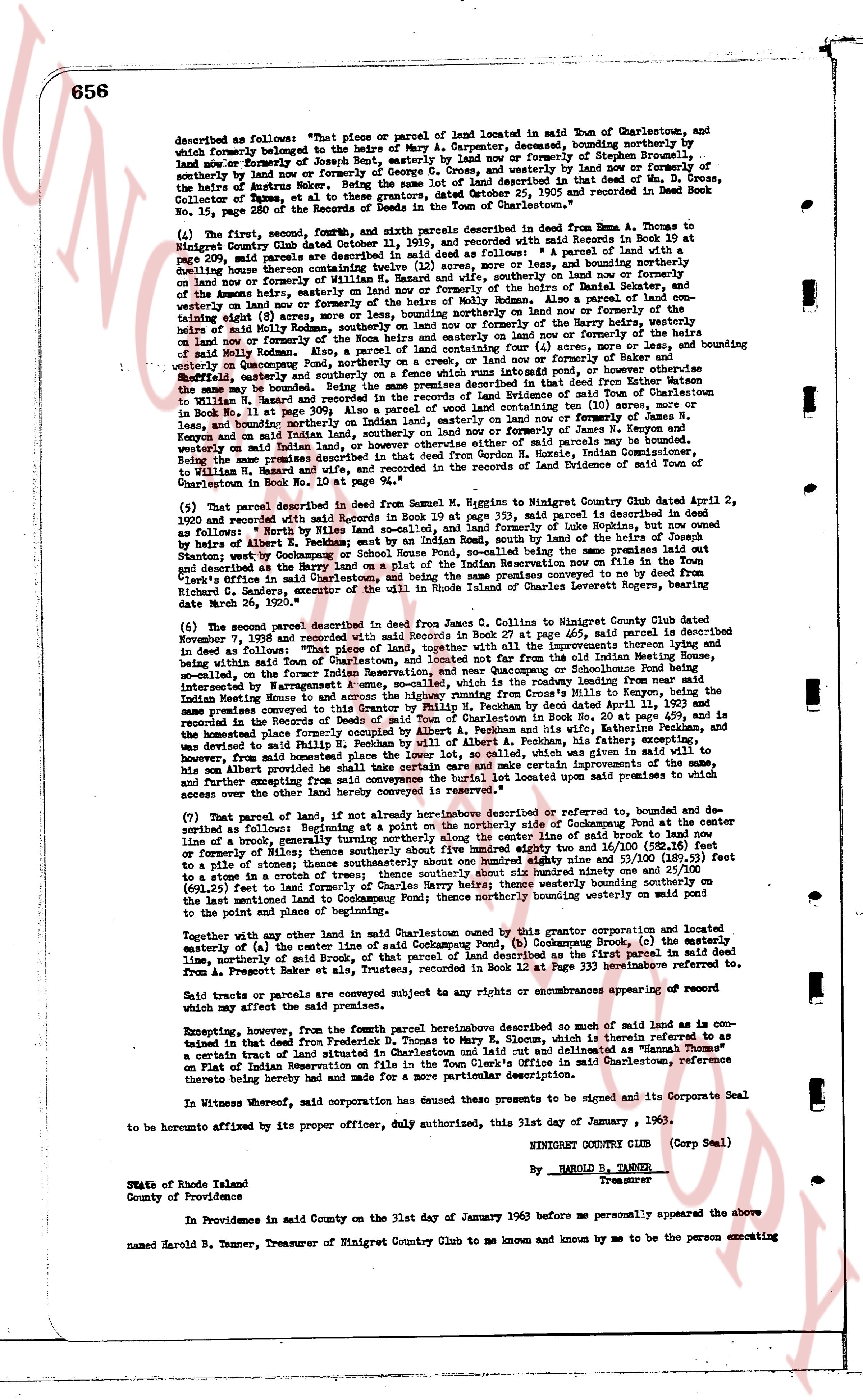
described as follows: "That piece or parcel of land located in said Town of Charlestown, and
which formerly belonged to the heirs of Mary A. Carpenter, descending, bounding northerly by
land and/or Externally of Joseph Bent, easterly by land and/or Externally of Stephen G. Cross, and
westerly by land and/or Externally of Stephen G. Cross, and westerly by land and/or normally of
the heirs of Anutus Roker. Being the same lot of land described in that deed of conveyance,
dated June 25, 1905 and recorded in Deed Book
No. 15, page 280 of the Records Deeds of the Town of Charlestown."
(4) The first, second, fourth, fifth, and sixth parcels described in said Deed from Anna T. Thomas to
Ninigret Country Club dated October 24, 1936 and recorded with said Records in Book 19 at
page 209, said parcels are described in said deed as follows: " A parcel of land with a
dwelling house thereon measuring 100 feet in width, more or less, and bounding northerly by
land and/or normally of William H. Narragansett, and northerly, southerly on land nor westerly on
of the Amons heirs, easterly on land and/or normally of the heirs of Molly Ransom. Also a parcel of land con-
taining eighty (8) acres, more or less, bounding northerly on land and/or normally of the heirs of
eighty (8) acres of land and/or normally of the heirs of Molly Ransom and southerly on land and/or
nor on land and/or normally of the Roma heirs and easterly on land and/or normally of the heirs of
William H. Narragansett. Also a parcel of land containing four (4) acres, more or less, bounding
westerly on Quonochontaug Pond, northerly on a creek, or on land and/or normally, more or less,
bounding southerly on land and/or normally of the heirs of Narragansett pond and easterly on land
the same may be bounded. Being the same premises described in that Deed from Nathan T. Thomas
to Emma T. Thomas his wife, dated June 25, 1905 and recorded in the Land Evidence Records of
in Book No. 15, on page 309. Also a parcel of land containing ten (10) acres, more or less,
and bounding northerly by land and/or normally of land and/or normally of J. Stephen G. Cross,
longly and on said Indian land, southerly on land and/or normally of land and/or normally of J. Stephen G.
westerly on said Indian land. Also a parcel of land of said premises paid to me by the
same conditions described in that deed from Gordon H. Hurdie, Indian Commissioner,
to William H. Narragansett, and recorded in the Records of Land Evidence of said Town of
Charlestown, in Book No. 19, page 209."
(5) That parcel described in deed from Samuel M. Higgins to Ninigret Country Club dated April 2,
1920 and recorded with said Records in Book 19 at page 353, said parcel is described in said deed
as follows: " A parcel of land situated on the Indian Reservation of Lake Hopkins, but now owned
by the heirs of Albert E. Peckham; bounded on the East Indian Road, south by the line of the heirs of
Joseph Bent, and north by the line of the heirs of Stephen G. Cross and on the west bounded as
and described by the heirs of Albert E. Peckham on a plot of the Indian Reservation now on file in the Town's
clerk's office in said Charlestown. Being the same land conveyed to me by a deed from Stephen G.
Richard C. Gardner, executor of the will of Charles Ingraham Loretto heirs, recorded in the Town's
date March 29, 1920."
(6) The second parcel described in deed from James Z. Collins to Ninigret Country Club dated
November 7, 1928 and recorded with said Records in Book 27 at page 465, said parcel is described
in said Deed as follows: " That piece of land, situated in said Town of Charlestown, being part of the
within said Town of Charlestown, and being a lot not found far from the old Indian Newthing House,
so-called, on the former Indian Reservation, and near Quonochontaug Pond, bounding linear from near
interrupted by Narragansett Pond, and bounding on the east by the roadway leading from near said
Indian Newthing House to and across the highway running from Cross's Mills to the shore of
Narragansett Pond, and bounding on the north by the line of the heirs of Albert E. Peckham, dated April 11, 1921 and
recorded in the Records of Deeds of Town of Charlestown in Book No. 20, page 459, and
the homestead of Elias Thorne, deceased, and bounding on the south by the line of the heirs of
was devoted to said Philip H. Peckham by the will of Albert E. Peckham, his father, specifying
However, said land may be bounded, and the improvements located upon said land and
across over the said highway hereby conveyed in remainder."
(7) That parcel of land, if not already hereinabove described or referred to, bounded on the
center line of said Cockumsong Pond, and bounded on the
line of a trough running parallel to the shore of the center line of said brook to land now
or formerly of Mills; thence anotherly about five hundred eighty two and 30/100 (582.30) feet to
of a stone in a crotch of trees; thence anotherly about six hundred ninety one and 20/100 (691.20)
(401.50) feet to land formerly of the heirs of Molly Ransom, westerly bounding northerly on land
to the said mentioned land to Cockumsong Pond; thence northerly bounding westerly on paid pond
to the point and place of the beginning."
Together with any other land in said Charlestown bought by this grantor corporation and located
easterly of (a) the center line of said Cockumsong Pond, (b) Cockumsong Brook, (c) the easterly
line, northerly of said brook, of the Indian Reservation, and (d) the first mentioned parcel described as
from A. Anutus Roker. Being the same land described in Book 12 at Page 333 hereinbefore referred to,
to the grantor.
Said tracts and parcels are conveyed subject to any rights or encumbrances appearing of record
which may affect the said premises.
Excepting, however, from the Fourth parcel hereinabove described no such of said land as is con-
tained in that deed from Frederic D. Thomas to Mary E. Sloan, which is therefore set aside as
a certain tract of land situated in Charlestown and laid out and delineated as "Hannah Thorne's"
on Plat Indian Reservation, recorded in the County Recorder's Office in said Charlestown, reference
thereto being hereby made and made for a more particular description.
In Witness whereof, said corporation has caused these presents to be signed and its Corporate Seal
to be hereunto affixed by its proper officer, duly authorized, this 31st day of January, 1960.
NINIGRET COUNTRY CLUB (Corp Seal)
By HAROLD B. TANNER
Treasurer
State of Rhode Island
County of Providence
In Providence on said County on the 31st day of January 1960 before me personally appeared the above
named Harold B. Tanner, Treasurer of Ninigret Country Club to me known and known by me to be the person executing
page 3 · read by Gemma vision
657
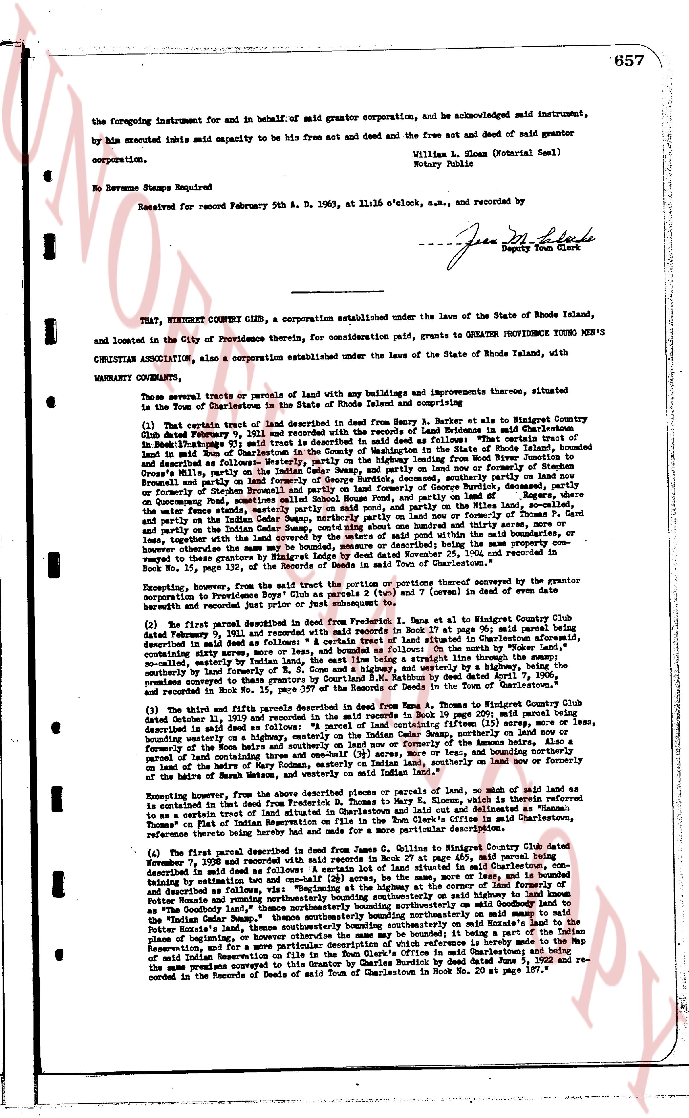
the foregoing instrument for and in behalf of said grantor corporation, and acknowledged said instrument,
by him executed inhis said capacity to be his free act and deed and the free act and deed of said grantor
corporation.
William L. Sloan (Notarial Seal)
Notary Public
No Revenue Stamps Required
Received for record February 5th A. D. 1963, at 11:16 o'clock, a.m., and recorded by
[Signature]
Jean M. Burke
Deputy Town Clerk
----
THAT, NINIGRET COUNTRY CLUB, a corporation established under the laws of the State of Rhode Island,
and located in the City of Providence therein, for consideration paid, grants to GREATER PROVIDENCE BOYS' CLUB
CHRISTIAN ASSOCIATION, also a corporation established under the laws of the State of Rhode Island, with
WARRANTY CONVEYANCE:
Those several tracts or parcels of land with any buildings and improvements thereon, situated
in the Town of Charlestown in the State of Rhode Island and comprising as follows:
(1) That certain tract of land described in deed from Henry A. Barker et als to Ninigret Country Club
dated February 9, 1936 and recorded with the records of Deeds of RIenidence in said Charlestown
in Book 24 page 311, which deed describes the said tract of land as follows: "The convex tract of
land in said Town of Charlestown in the County of Washington in the State of Rhode Island, bounded
and described as follows: Northerly by the land of the Providence Boys' Club, then along the Rhode Island
Crooks's Mills, partly on the Indian Cedar Swamp, and partly on land now or formerly of Hishen
Brownell and partly on the land of Hishen Brownell and partly on the former Garage of George Burdick,
descended from and partly on the land of George Burdick, westerly by the land of George Burdick,
on Pocomoke Pond, continuing south westerly along the water's edge partly on said pond, and partly on
the miles, now water, from state line, southeasterly by the land of George Burdick, partly on said pond, and
partly on the Indian Cedar Swamp, partly on said pond, northerly and partly on the miles, now water, and
partly on the land of Hishen Brownell, and partly on the land of George Burdick, more or less, and
together, with the land covered by the waters of said pond within the land described in said deed, more or
less, together with the land covered by the waters of said pond within the land described in said deed, more or
less, together with the land covered by the waters of said pond within the land described in said deed, more or
less, together with the land covered by the waters of said pond within the land described in said deed, more or
less, together with the land covered by the waters of said pond within the land described in said deed, more or
less, together with the land covered by the waters of said pond within the land described in said deed, more or
less, together with the land covered by the waters of said pond within the land described in said deed, more or
less, together with the land covered by the waters of said pond within the land described in said deed, more or
less, together with the land covered by the waters of said pond within the land described in said deed, more or
less, together with the land covered by the waters of said pond within the land described in said deed, more or
less, together with the land covered by the waters of said pond within the land described in said deed, more or
less, together with the land covered by the waters of said pond within the land described in said deed, more or
less, together with the land covered by the waters of said pond within the land described in said deed, more or
less, together with the land covered by the waters of said pond within the land described in said deed, more or
less, together with the land covered by the waters of said pond within the land described in said deed, more or
less, together with the land covered by the waters of said pond within the land described in said deed, more or
less, together with the land covered by the waters of said pond within the land described in said deed, more or
less, together with the land covered by the waters of said pond within the land described in said deed, more or
less, together with the land covered by the waters of said pond within the land described in said deed, more or
less, together with the land covered by the waters of said pond within the land described in said deed, more or
less, together with the land covered by the waters of said pond within the land described in said deed, more or
less, together with the land covered by the waters of said pond within the land described in said deed, more or
less, together with the land covered by the waters of said pond within the land described in said deed, more or
less, together with the land covered by the waters of said pond within the land described in said deed, more or
less, together with the land covered by the waters of said pond within the land described in said deed, more or
less, together with the land covered by the waters of said pond within the land described in said deed, more or
less, together with the land covered by the waters of said pond within the land described in said deed, more or
less, together with the land covered by the waters of said pond within the land described in said deed, more or
less, together with the land covered by the waters of said pond within the land described in said deed, more or
less, together with the land covered by the waters of said pond within the land described in said deed, more or
less, together with the land covered by the waters of said pond within the land described in said deed, more or
less, together with the land covered by the waters of said pond within the land described in said deed, more or
less, together with the land covered by the waters of said pond within the land described in said deed, more or
less, together with the land covered by the waters of said pond within the land described in said deed, more or
less, together with the land covered by the waters of said pond within the land described in said deed, more or
less, together with the land covered by the waters of said pond within the land described in said deed, more or
less, together with the land covered by the waters of said pond within the land described in said deed, more or
less, together with the land covered by the waters of said pond within the land described in said deed, more or
less, together with the land covered by the waters of said pond within the land described in said deed, more or
less, together with the land covered by the waters of said pond within the land described in said deed, more or
less, together with the land covered by the waters of said pond within the land described in said deed, more or
less, together with the land covered by the waters of said pond within the land described in said deed, more or
less, together with the land covered by the waters of said pond within the land described in said deed, more or
less, together with the land covered by the waters of said pond within the land described in said deed, more or
less, together with the land covered by the waters of said pond within the land described in said deed, more or
less, together with the land covered by the waters of said pond within the land described in said deed, more or
less, together with the land covered by the waters of said pond within the land described in said deed, more or
less, together with the land covered by the waters of said pond within the land described in said deed, more or
less, together with the land covered by the waters of said pond within the land described in said deed, more or
less, together with the land covered by the waters of said pond within the land described in said deed, more or
less, together with the land covered by the waters of said pond within the land described in said deed, more or
less, together with the land covered by the waters of said pond within the land described in said deed, more or
less, together with the land covered by the waters of said pond within the land described in said deed, more or
less, together with the land covered by the waters of said pond within the land described in said deed, more or
less, together with the land covered by the waters of said pond within the land described in said deed, more or
less, together with the land covered by the waters of said pond within the land described in said deed, more or
less, together with the land covered by the waters of said pond within the land described in said deed, more or
less, together with the land covered by the waters of said pond within the land described in said deed, more or
less, together with the land covered by the waters of said pond within the land described in said deed, more or
less, together with the land covered by the waters of said pond within the land described in said deed, more or
less, together with the land covered by the waters of said pond within the land described in said deed, more or
less, together with the land covered by the waters of said pond within the land described in said deed, more or
less, together with the land covered by the waters of said pond within the land described in said deed, more or
less, together with the land covered by the waters of said pond within the land described in said deed, more or
less, together with the land covered by the waters of said pond within the land described in said deed, more or
less, together with the land covered by the waters of said pond within the land described in said deed, more or
less, together with the land covered by the waters of said pond within the land described in said deed, more or
less, together with the land covered by the waters of said pond within the land described in said deed, more or
less, together with the land covered by the waters of said pond within the land described in said deed, more or
less, together with the land covered by the waters of said pond within the land described in said deed, more or
less, together with the land covered by the waters of said pond within the land described in said deed, more or
less, together with the land covered by the waters of said pond within the land described in said deed, more or
less, together with the land covered by the waters of said pond within the land described in said deed, more or
less, together with the land covered by the waters of said pond within the land described in said deed, more or
less, together with the land covered by the waters of said pond within the land described in said deed, more or
less, together with the land covered by the waters of said pond within the land described in said deed, more or
less, together with the land covered by the waters of said pond within the land described in said deed, more or
less, together with the land covered by the waters of said pond within the land described in said deed, more or
less, together with the land covered by the waters of said pond within the land described in said deed, more or
less, together with the land covered by the waters of said pond within the land described in said deed, more or
less, together with the land covered by the waters of said pond within the land described in said deed, more or
less, together with the land covered by the waters of said pond within the land described in said deed, more or
less, together with the land covered by the waters of said pond within the land described in said deed, more or
less, together with the land covered by the waters of said pond within the land described in said deed, more or
less, together with the land covered by the waters of said pond within the land described in said deed, more or
less, together with the land covered by the waters of said pond within the land described in said deed, more or
less, together with the land covered by the waters of said pond within the land described in said deed, more or
less, together with the land covered by the waters of said pond within the land described in said deed, more or
less, together with the land covered by the waters of said pond within the land described in said deed, more or
less, together with the land covered by the waters of said pond within the land described in said deed, more or
less, together with the land covered by the waters of said pond within the land described in said deed, more or
less, together with the land covered by the waters of said pond within the land described in said deed, more or
less, together with the land covered by the waters of said pond within the land described in said deed, more or
less, together with the land covered by the waters of said pond within the land described in said deed, more or
less, together with the land covered by the waters of said pond within the land described in said deed, more or
less, together with the land covered by the waters of said pond within the land described in said deed, more or
less, together with the land covered by the waters of said pond within the land described in said deed, more or
less, together with the land covered by the waters of said pond within the land described in said deed, more or
less, together with the land covered by the waters of said pond within the land described in said deed, more or
less, together with the land covered by the waters of said pond within the land described in said deed, more or
less, together with the land covered by the waters of said pond within the land described in said deed, more or
less, together with the land covered by the waters of said pond within the land described in said deed, more or
less, together with the land covered by the waters of said pond within the land described in said deed, more or
The page as recorded