The instrument's own words
page 1 · read by Gemma vision
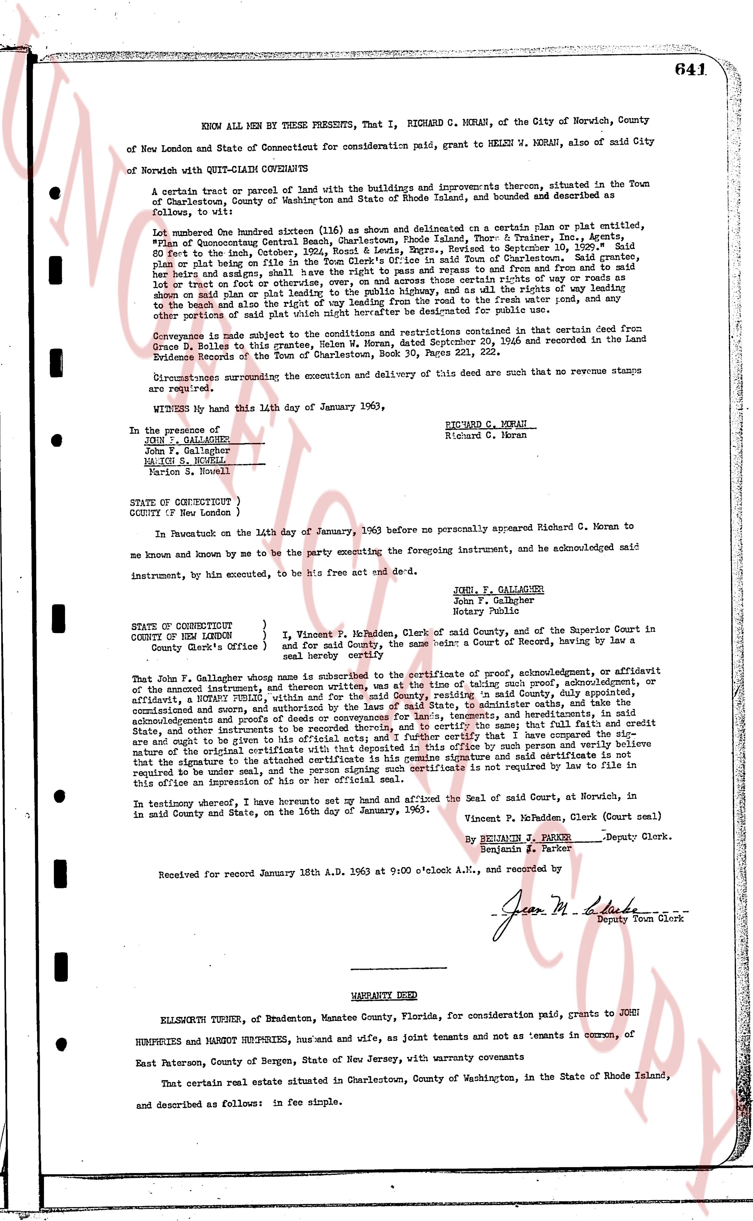
641
KNOW ALL MEN BY THESE PRESENTS, That I, RICHARD C. MORAN, of the City of Norwich, County of New London and State of Connecticut for consideration paid, grant to HELEN W. MORAN, also of mid City of Norwich with QUIT-CLAIM COVENANTS:
A certain tract or parcel of land with the buildings and improvements thereon, situated in the Town of Charlestown, County of Washington and State of Rhode Island, and bounded and described as follows, to wit:
Lot number One hundred sixteen (116) as shown and delineated on a certain plan or plat entitled, "Plan of Quonochontaug Beach Charlestown, Rhode Island Town, Book & Trailer, Inc. & Agency," 50 feet in the North boundary, Rear 50 feet, East 100 feet, West 100 feet, bounded to Southeast by Lot 115, bounded on plan and plat being in the file of the Town Clerk's Office in said Town of Charlestown. Said grantor, heirs and assigns, shall have the right to use the road and path leading to the beach from the road and path on the West on part or parts thereof, or overly, and on across these certain rights of way roads or paths on said plan or plat therefore, and shall have the right to use all the rights of way roads or paths on said plan or plat leading from the road to the beach way leading from the road to the fresh water pond, and any other portions of said plat which may hereafter be dedicated for public use.
Conveyance is made subject to the conditions and restrictions contained in that certain deed from Gene D. Rulon to this grantor, dated September 20, 1956 and recorded in the Land Evidence Records of the Town of Charlestown, Book 36, Pages 221, 222.
Circumstances surrounding the execution and delivery of this deed are such that no revenue stamps are required.
WITNESS my hand this 14th day of January 1963,
RICHARD C. MORAN
Richard C. Moran
In the presence of
JOHN P. GALLAGHER
John P. Gallagher
MARION S. MORAN
Marion S. Moran
STATE OF CONNECTICUT
COUNTY of New London )
In Pawtucket on the 14th day of January, 1963 before me personally appeared Richard C. Moran to me known and known by me to be the party executing the foregoing instrument, and be acknowledged said instrument, by him executed, to be his free act and deed etc.
JOHN P. GALLAGHER
John P. Gallagher
Notary Public
STATE OF CONNECTICUT
COUNTY of NEW LONDON } I, Vincent P. Mc Madden, Clerk of said County, and of the Superior Court in said
COUNTY of NEW LONDON } and for said County, the same being a Court of Record, having by law a
County Clerk's Office & in said County
That John P. Gallagher, officer named above is subscribed to the certificate of proof, acknowledgment, or affidavit of the annexed instrument, and written thereon, was at the time of taking such proof, acknowledgment, or affidavit, a resident, EMPLOYED therein, with a commission to practice in said County, and of the State of Connecticut, commissioned and sworn, and authorized by the Laws of said State, to administer oaths, and take acknowledgments and proofs, and that said officer is duly commissioned, competent, and authorized by the laws of said State and other instruments to be recorded thereby, and to certify the same; that I have full and faith and credit are ought to be given to his official acts, and that I have checked with that deposited in this office and believe that the original certificate to be annexed with that deposited in this office by such person and verily believe nature that the signature to the attached certificate is his genuine signature and said certificate is not required by law to file in this office an impression of his or her official seal.
In testimony hereof, I have hereunto set my hand and affixed the Seal of said Court, at Norwich, in said County and State, on the 16th day of January, 1963.
Vincent P. Mc Madden, Clerk (Court seal)
By BENJAMIN J. FACTOR
Benjamin J. Factor Deputy Clerk.
Received for record January 18th A.D. 1963 at 9:00 o'Clock A.M., and recorded by
Jean M. La Duke Deputy Town Clerk
----
WARRANTY DEED
ELLSWORTH TURNER, of Bradenton, Manatee County, Florida, for consideration paid, grant to JOHN HUMPHRIES and MARGOT HUMPHRIES, hus band and wife, as joint tenants and not as tenants in common, of East Paterson, County of Bergen, State of New Jersey, with warranty covenants
That certain real estate situated in Charlestown, County of Washington, in the State of Rhode Island, and described as follows: in fee simple.
page 2 · read by Gemma vision
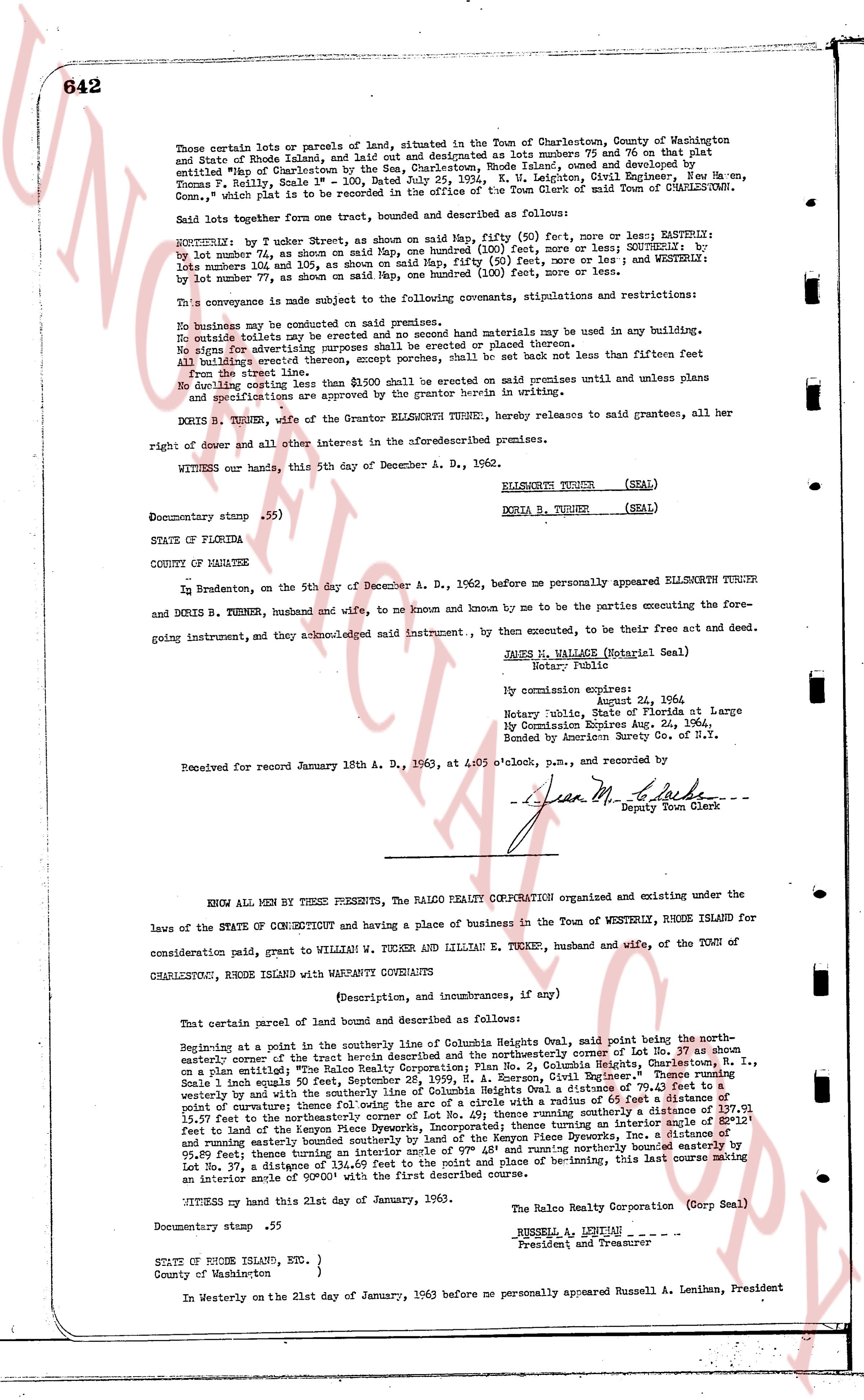
642
Those certain lots or parcels of land, situated in the Town of Charlestown, County of Washington state of Rhode Island, and laid out and designated as lots numbers 75 and 76 on that plat entitled "Map of Charlestown by the Sea, Charlestown, Rhode Island, owned and developed by Thomas F. Reilly, Seat's End, Charlestown, Rhode Island, and Letitia L. Lettsong, died domiciled New Haven, Conn.," said plat is to be recorded in the office of the Town Clerk of said Town of CHARLESTOWN.
Said lotters together form one tract, bounded and described as follows:
NORTHERN: by 2 Turner Street, as shown on map, fifty (50) feet, more or less; EASTERN: by lot number 74, as shown on said Map, one hundred (100) feet, more or less; SOUTHERN: by lots number 101 and 102, as shown on said Map, fifty (50) feet, more or less; and WESTERN: by lot number 77, as shown on said Map, one hundred (100) feet, more or less.
This conveyance is made subject to the following covenants, stipulations and restrictions:
No business may be conducted on said premises.
No rentals outside the family may be made.
No signs for advertising purposes shall be erected or placed thereon.
No buildings exceed two stories in height.
All buildings erected thereon, except porches, shall be set back not less than fifteen feet from the line street.
No building costing less than $1,500 shall be erected on said premises unless and until plans and specifications are submitted and approved in writing.
DORIA B. TURNER, wife of the Grantor ELLSWORTH TURNER, hereby releases to said grantees, all her right of dower and all other interest in the aforementioned premises.
WITNESS our hands, this 5th day of December A. D., 1962.
ELLSWORTH TURNER (SEAL)
DORIA B. TURNER (SEAL)
Documentary stamp .55)
STATE OF FLORIDA
COUNTY OF MANATEE
In Bradenton, on the 5th day of December A. D., 1962, before me personally appeared ELLSWORTH TURNER and DORIA B. TURNER, husband and wife, to me known and by me to be the parties executing the foregoing instrument, and they acknowledged said instrument, to be their free act and deed.
JAMES W. WALLACE (Notarial Seal)
Notary Public
My commission expires:
August 24, 1964.
Notary Public, State of Florida at Large
By Commission Expires Aug. 24, 1964.
Bonded by American Surety Co. of N.Y.
Received for record January 18th A. D., 1963, at 10:05 o'clock, p.m., and recorded by
Jean M. Clarke
Deputy Town Clerk
----
KNOW ALL MEN BY THESE PRESENTS, THE RALCO REALTY CORPORATION organized and existing under the laws of the STATE OF CONNECTICUT and having a place of business in the Town of WESTERLY, RHODE ISLAND for consideration paid, grant to WILLIAM W. TURNER and LILLIAN E. TURNER, husband and wife, of the TOWN of CHARLESTOWN, RHODE ISLAND with WARRANTY CONVEYANCE
(Description, and incumbrances, if any)
That certain parcel of land bound and described as follows:
Beginning at a point in the southerly line of Columbia Heights Oval, said point being the northwesterly corner of eitherly corner of the trust beach described and the northeasterly corner of Lot No. 47 as shown on a plat entitled "Map of Ralco Realty Corporation, Columbia Heights, Charlestown, R. I., size of plat 20" x 24" filed in the office of the Town Clerk of Charlestown, R. I., signed by Thomas F. Reilly souls 50 feet, December 25, 1959, p. 4, Annexure C, Grantor Representative." Thence running easterly along the southerly line of Columbia Heights Oval, a distance of 107.01 feet thence running westerly by and with the northerly line of Columbia Heights Oval, a circle with a radius of 65 feet a distance of 107.01 feet then running southerly by and with the easterly line of Lot No. 47, a distance of 177.91 feet to the northerly line of the keeper's cottage, thence running easterly along said line turning an interior angle of S 0°12' east to land of the Kenyon Piece Dyerecks, Inc. a distance of 111.31 feet thence turning an interior angle of S 0°12' east running easterly bounded southerly by land of the Kenyon Piece Dyerecks, Inc. a distance of 108.87 feet bounded easterly by 95.89 feet thence turning an interior angle of N 0°12' west then running northerly a distance of 111.31 feet to Lot No. 37, a distance of 134.69 feet to the lot and place of be-ginning, this last course making an interior angle of 90°00' with the first described course.
WITNESS my hand this 21st day of January, 1963.
The Ralco Realty Corporation (Corp Seal)
RUSSELL A. LENIMAN
President and Treasurer
Documentary stamp .55
STATE OF RHODE ISLAND, Etc. )
County of Washington }
In Westerly on the 21st day of January, 1963 before me personally appeared Russell A. Leniman, President
The page as recorded