The Deed Walker · From Ninigret · Charlestown, Rhode Island land evidence, 1738 to today
Trail: 90@27/618 › 75@26/332 › 77@26/334

5/11/1936 · DEED · book 26 page 334 doc 77@26/334

From BAKER ELEANOR D life, BAKER HOWARD HAMILTON
To BROWN ALBERT E life
Premises none · Northerly half of lot #450 (Quonsetcong Beach, Charlestown)
Index description SEE DOC

Back — where this land came from

This instrument states no source of title that we have read yet.

The grantor's earlier acquisitions, by name — the man, not necessarily this land

◀ 1936 · DEED · BROWN ALBERT E → BAKER ELEANOR D; BAKER HOWARD HAMILTON · book 26 p 333
◀ 1936 · MORTGAGE DISCHARGE · WAKEFIELD TRUST CO → BAKER HOWARD HAMILTON BY ATTORNEY; BAKER ELEANOR D · book 23 p 162
◀ 1936 · PARTIAL RELEASE · COLONIAL FINANCE CORPORATION → BAKER ELEANOR D · book 26 p 321
◀ 1936 · PARTIAL RELEASE · COLONIAL FINANCE CORPORATION → BAKER ELEANOR D · book 26 p 326
◀ 1936 · PARTIAL RELEASE · J N ADAMS CO INC → BAKER ELEANOR D · book 26 p 327
◀ 1936 · PARTIAL RELEASE · J N ADAMS CO INC → BAKER ELEANOR D · book 26 p 328
◀ 1936 · PARTIAL RELEASE · SARGENT PRTOER E → BAKER ELEANOR D · book 26 p 329
◀ 1936 · PARTIAL RELEASE · SARGENT PORTER E → BAKER ELEANOR D · book 26 p 330
◀ 1936 · DEED · BROWN ALBERT E → BAKER ELEANOR D · book 26 p 332
◀ 1935 · DEED · WAKEFIELD TRUST CO → BAKER ELEANOR D · book 26 p 154
◀ 1935 · PARTIAL RELEASE · COLONIAL FINANCE CORP → BAKER ELEANOR D · book 26 p 154
◀ 1935 · RELEASE STANDARD · J N ADAM & CO → BAKER ELEANOR D · book 26 p 155
◀ 1935 · RELEASE STANDARD · JH ADAMS & CO → BAKER ELEANOR D · book 24 p 525
◀ 1933 · PARTIAL RELEASE · WAKEFIELD TRUST CO → BAKER ELEANOR D · book 25 p 383

Forward — where this land went

The grantee's later conveyances, by name — the man, not necessarily this land; the one that cites this deed as its source is the land

▶ 1936 · DEED · BROWN ALBERT E → BAKER ELEANOR D · book 26 p 332
▶ 1936 · DEED · BROWN ALBERT E → BAKER ELEANOR D; BAKER HOWARD HAMILTON · book 26 p 333
▶ 1936 · DEED · BROWN ALBERT E → CROSS GEORGE W · book 26 p 364
▶ 1936 · DEED · BROWN ALBERT E → HAZARD JOSEPH M; HAZARD NANCY E · book 26 p 407
▶ 1936 · DEED · BROWN ALBERT E → GARD THOMAS; GARD ELIZA J · book 26 p 487
▶ 1936 · DEED · BROWN ALBERT E → BUCK FLORENCE E; GARDINER HARRISON J · book 26 p 551
▶ 1937 · DEED · BROWN ALBERT E → BLIVEN ANNIE; BLIVEN GEORGE W · book 27 p 78
▶ 1937 · DEED · BROWN ALBERT E → BARBER MYRTLE; BARBER WILLIAM P G · book 27 p 144
▶ 1937 · DEED · BROWN ALBERT E → HOXIE GEORGE W; HOXIE LILLIAN G · book 27 p 180
▶ 1938 · DEED · BROWN ALBERT E → PIETILA MARY K; PIETILA MICHAEL · book 27 p 273
▶ 1938 · DEED · BROWN ALBERT E → MAYO FRANCES; MAYO JAMES · book 27 p 287
▶ 1938 · DEED · BROWN ALBERT E → BRIGHTMAN ALICE M; BRIGHTMAN CHARLES S; BRIGHTMAN HENRY S · book 27 p 308
▶ 1938 · MORTGAGE DISCHARGE · BROWN ALBERT E → SMITH JOHN W; SMITH MABEL P · book 27 p 358
▶ 1940 · MORTGAGE DISCHARGE · BROWN ALBERT E → SAUNDERS ALBERT A; SAUNDERS NELLIE F · book 25 p 686
▶ 1942 · MORTGAGE DISCHARGE · BROWN ALBERT E → SMITH JOHN W; SMITH MABEL F · book 27 p 422
▶ 1942 · DEED · BROWN ALBERT E → ODONNELL EUGENE C; ODONNELL RUTH M · book 28 p 623

The instrument's own words

page 1 · read by Gemma vision
170 CHARLESTOWN ESTATES, INC. a corporation duly incorporated under the laws of the State of Rhode Island and having a place of business in the Town of Westerly, County of Washington, State of Rhode Island, for consideration paid grant to R. LILLIAN JENNETT, of the City, County and State of New York, with WARRANTY COVENANTS A certain tract or parcel of real estate located on the Westerly side of Highland Road, so called, at Quonsetcong Beach in the Town of Charlestown, County of Washington and State of Rhode Island and bounded and described as follows, to wit: The Northerly half of lot #450 as shown and delimited on a certain plan or plat entitled "Plat of East Beach at Quonsetcong, Rhode Island, property of S. H. Davis, Inc., Leo L. Holland, C. E., Scale one inch equals 100 feet, Revised July 13, 1931" said plat being duly filed in the Land evidence Records of said Town of Charlestown. In consideration of the purchase price it is understood and agreed that this parcel of land, 25 feet in width and 140, or more or less, in depth extending along the Southerly boundary of land of this grantees shall be considered as a part of lot #452 which was purchased by this grantees from Charlestown estates, Inc. by deed dated Novem- ber, 1932 and duly recorded in the Land Evidence Records of said Town of Charlestown. All of the restrictions and reservations as were contained in the deed to lot 452 shall be considered to run with this parcel of land. The grantees, their heirs, executors, administrators, assigns, licensees, ser- vants or agents shall have the right in common with others to cross over and across lot No. 489 as shown on said plat from Atlantic Avenue to the beach; and the grantees, their heirs, executors, administrators, assigns, licensees, servants or agents shall have the right in common with others to cross and recross at all times and for all purposes over that certain Lot no. 538 on said plat and the twenty-five foot right of way leading from the highway to said lot, as all shown on said plat. IN WITNESS WHEREOF the said Corporation has caused these presents to be signed by its President and Treasurer, hereunto duly authorized, and the corporate seal to be hereunto affixed at Westerly, Rhode Island, this 21st day of February A. D., 1940. (Corporate Seal) CHARLESTOWN ESTATES, INC. Howard L. Thorp President Nelson M. Thorp Treasurer (INTERNAL REVENUE STAMP, 50c) STATE OF RHODE ISLAND COUNTY OF WASHINGTON In Westerly on this 21st day of February, 1940, before me personally appeared Howard S. Thorp, to me known and known by me to be the President of said Corporation, and Nelson M. Thorp, to me known and known by me to be the Treasurer of said Corporation; and they acknowledged said instrument by them executed to be the free act and deed of said Corporation and as well individually. ROGERS E. TRAINER (Notarial Seal) Received for record February 28th, A. D. 1940 at 9:15 o'clock, a. m., and recorded by Town Clerk

The page as recorded
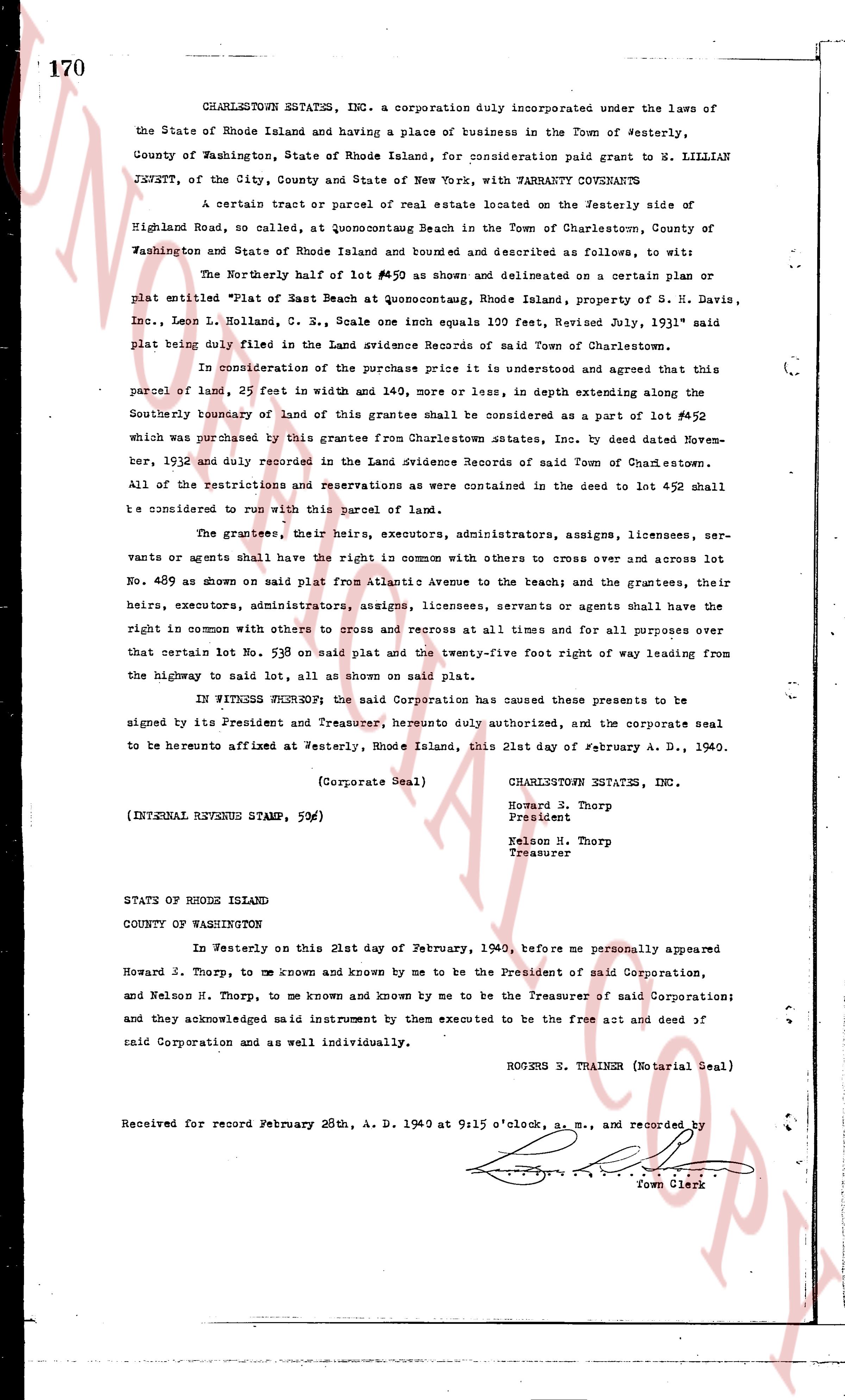
page 1

deed_walker_v1.9_2026-10-10 · the index is the town's own (i2l.uslandrecords.com); transcripts, chains and the assessor's cards are the Perry Machine's reading of it. Where the record we hold runs out, the page says so.