The instrument's own words
Attribution under review. The portal's file number is shared by more than one instrument, and the words below could not be placed with certainty on this one by their own evidence (page stamp, parties, dates); they may belong to a neighbouring instrument. Read them as the record of the page, not yet as this deed's own.
page 1
581
DEED OF EASEMENT
KNOW ALL MEN BY THESE PRESENTS That Quonocutnang Central Beach Fire District, a Rhode Island corporation, having
its principal office in the Town of Charlestown, Rhode Island, for consideration paid, hereby grants and conveys to
Town of Charlestown, an incorporated Town in the State of Rhode Island, the right and easement in perpetuity along the
north side of Lot Number 63 (sixty-three) that certain plat - entitled, "Plot of Quonocutnang Highlands, property of
Charlestown Estates, Inc., Charlestown, R. I., scale 1 inch equals 50 feet, August, 1940, Roseli & Lewis, Engrs.," for
the purpose of draining storm water or surface water, so-called, from Sunset Avenue to Quonocutnang Pond.
IN WITNESS WHEREOF Quonocutnang Central Beach Fire District has hereunto caused its name and corporate seal to
be affixed hereto and this instrument to be executed on its behalf by its Moderator and its Secretary for this purpose
duly authorized, this 29th day of September, 1962.
QUONOCUTNANG CENTRAL BEACH FIRE DISTRICT
By Nelson H. Thorp
Moderator
John Yale Coulter
Secretary
STATE OF RHODE ISLAND
COUNTY OF WASHINGTON
At Charlestown, on the 29th day of September, 1962 before me personally appeared Nelson H. Thorp, Moderator, and
John Y. Coulter, Secretary, of Quonocutnang Central Beach Fire District, to me so known and known by me to be the parties
executing the foregoing instrument; and they acknowledged said instrument, by them so executed to be their free act
and deed in their said capacities and the free act and deed of Quonocutnang Central Beach Fire District.
HOWARD W. THORP
Notary Public
Received for record November 14th, A. D. 1962 at 9:10 o'clock, a. m., and recorded by
[Signature]
Town Clerk
QUIT CLAIM DEED
CHARLESTOWN ESTATES, INC., a Corporation duly incorporated under the Laws of the State of Rhode Island, and
having a place of business in the Town of Westerly, County of Washington and State of Rhode Island, for consideration
paid given to the Town of Charlestown, a Municipal Corporation located in the County of Washington and State of Rhode
Island, with the QUIT-CLAIM COVENANTS,
That a certain strip or parcel of land located westerly from the Old West Beach Road, so called, at Quonocutnang
in the Town of Charlestown, County of Washington and State of Rhode Island, bounded and described
as follows, to wit:
Beginning at a point on the westly line of the westerly line of said West Beach Road, said point being located a distance of
113.58 feet northerly from the southeasterly corner of said Nelson B. Doyle; taxpayer; thence running southeasterly
113.58 feet southeasterly and westerly along the arc of a corner cut off where said West Beach Road turns from a southerly
to the point of intersection with the westerly line of said West Beach Road; thence running westerly along the northerly
line of said street 577.86 feet to the intersection of Road E. and Harry S. Thorp st. a point on the boundary of the
Estate of Harry S. Thorp; thence running northerly along the boundary of said Estate northerly to the beginning
of a curve having a radius of 1064.03 feet and continuing along the arc of said curve in a southeasterly
a direction of 1 degree 21 minutes 15 seconds to the point of tangency; thence running southeasterly along the
line in a southeasterly direction 915.12 feet to the beginning of another curve having a radius of 373.10 feet
and continuing along the arc of said curve in a southeasterly direction of 15 degrees 1 minute 30 seconds
and continuing along the arc of said curve to the point of tangency; thence continuing southeasterly 398.58 feet to the beginning of a corner cut off
with curve having a radius of 30 feet, thence southeasterly along the arc of said curve to the point of tangency;
thence continuing southeasterly along the boundary of said corner cut off curve 47.72 feet to the intersection
with the northerly line of the Old West Beach Road thence easterly along the northerly line of said
West Beach Road 110.20 feet to the beginning of another curve having a radius of 30 feet; thence southeasterly
of northerly and more easterly around said corner cut off to the intersection of the northerly line of said West Beach Road
and continuing along the arc of said curve to the point of tangency; thence continuing 398.58 feet to the beginning of
a curve having a radius of 339.13 feet and continuing northerly and more easterly around said curve to the
point of tangency; thence continuing northerly 915.12 feet to the beginning of another curve having a
radius of 1064.03 feet; thence northerly and northeastly along the arc of said curve 169.50 feet to the
point of tangency; thence running northerly along the boundary of the Estate of Harry S. Thorp to the beginning
of a corner cut off having a radius of 30 feet; thence northerly, more northerly,
and easterly around the arc of said corner cut off curve having a radius of 30 feet; thence northerly, more northerly
and easterly around the northerly line of said street 515.66 feet to the beginning of a corner cut off curve having a
radius of 30 feet; thence continuing northerly around said corner cut off curve and easterly along the
intersection with the northerly line of the West Beach Road; thence northerly along the westerly line of the
said West Beach Road 100.20 feet to the point and place of beginning.
Meaning and intent and intending to convey Sunset Avenue from the Old West Beach Road on the south, northerly and easterly
to the intersection with the West Beach Road on the north, as shown on certain plan or plat entitled, "Quonocutnang
Highlands, property of Charlestown Estates, Inc., Charlestown, R. I., scale 1 inch equals 50 feet, August, 1940,
Roseli & Lewis, Engrs.," Said plat being duly filed in the Town Clerk's Office of the Town of Charlestown.
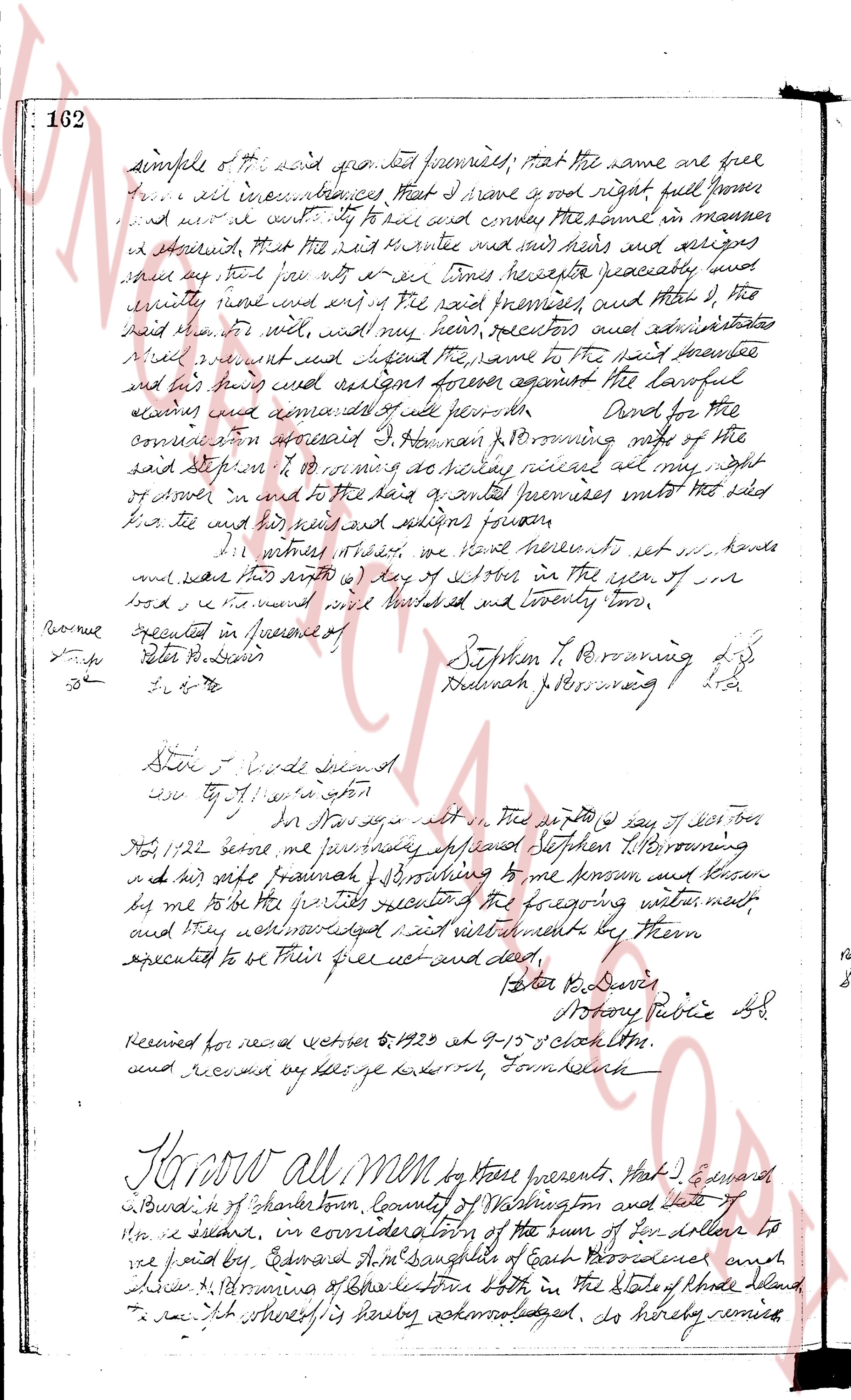
page 2
162
simple of the said granted premises, that the same are free
from all incumbrances, that I have good right full power
and authority to sell and convey the same in manner
as aforesaid, that the said grantee and his heirs and assigns
shall have for ever with all tenets thereto appertaining free
quietty use and enjoy the said premises, and that I, the
said grantor, with my wife, with my heirs, executors and assigns
will warrant and defend the same to the said grantee
and his heirs and assigns forever against the lawful
claims and demands of all persons. And for the
consideration aforesaid I do hereby grant remise release and
devise to Stephen T. Browning and his heirs whoever they are
of myself in and to the said granted premises unto me not sold
his the said heirs and assigns forever
In witness whereof we have hereunto set our hands
and seals this 24th day of October in the year of our
Lord one thousand eight hundred and twenty two.
Executed in presence of
Peter B. Davis
do
J. S. G.
Stephen T. Browning
Deborah T. Browning
State of Providence
County of Providence
On this 24th day of October
1822 before me personally appeared Stephen T. Browning
and his wife Deborah T. Browning to me known and known
by me to be the parties respectively of the foregoing instrument
and they acknowledged said instrument to be their
executed to be their free act and deed,
Peter B. Davis
Notary Public SS
Received for record October 24 1822 at 9:30 o clock a.m.
and recorded by me George Haskell Town Clerk.
Know all men by these presents, That I Edward
Browning of Charlestown, County of Washington and late of
the same place, in consideration of the sum of ten dollars to
be paid by Edward A. McShane of East Greenwich and
Deborah T. Browning of Charlestown both in the State of Rhode Island,
the receipt whereof is hereby acknowledged, do hereby remise
The page as recorded