The instrument's own words
page 1 · read by Gemma vision
569
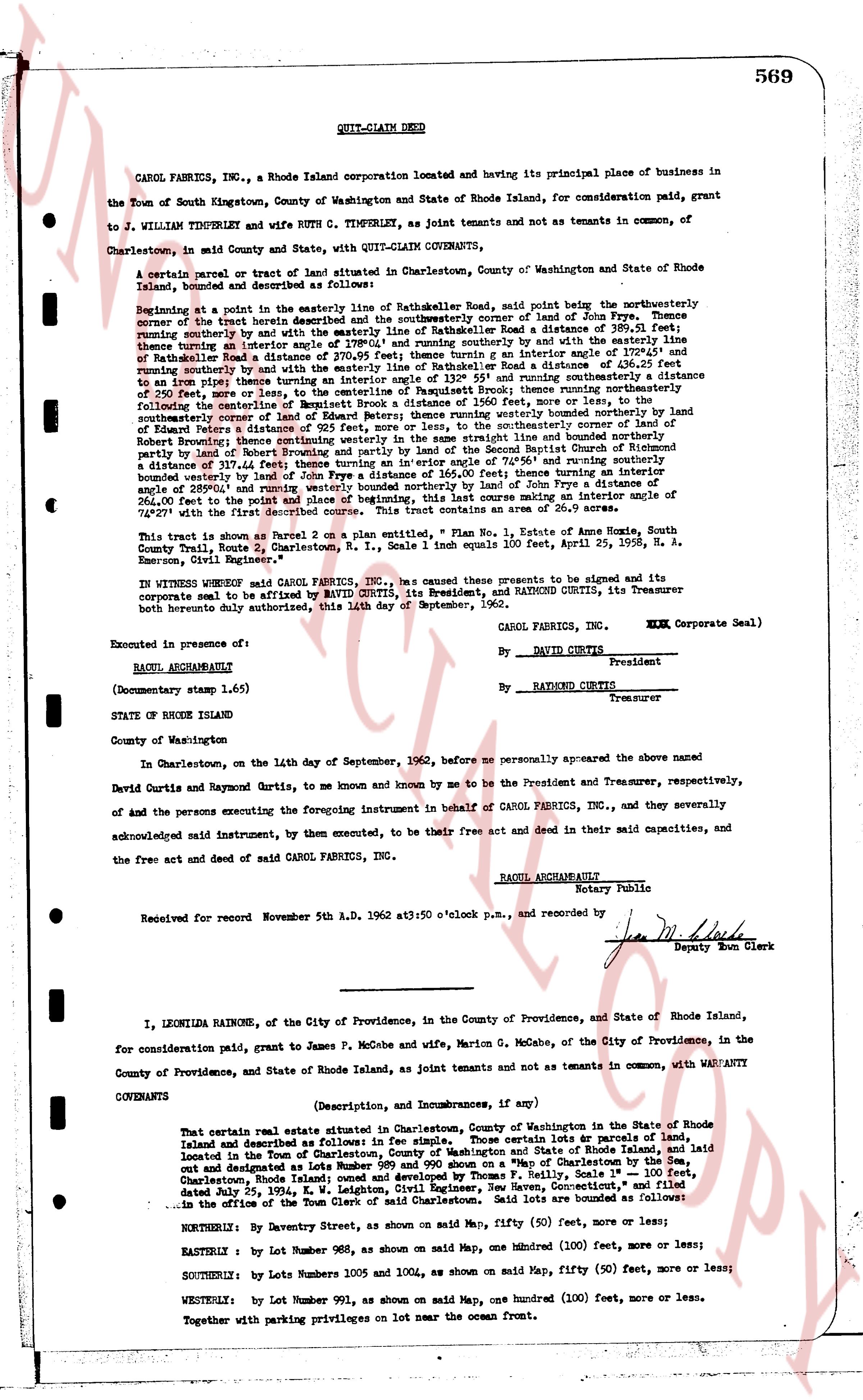
QUIT-CLAIM DEED
CAROL FABRICS INC., a Rhode Island corporation located and having its principal place of business in the Town of South Kingstown, County of Washington and State of Rhode Island, for consideration paid, grant to
J. WILLIAM TIMPERLEY and wife RUTH C. TIMPERLEY, as joint tenants and not as tenants in common, of Charlestown, in said County and State, with QUIT-CLAIM COVENANTS,
a certain parcel or tract of land situated in Charlestown, County of Washington and State of Rhode Island, bounded and described as follows, and known as Lot 1, as shown on a map dated 11/1/1962:
Beginning at a point in the easterly line of the easterly R.O.W. of Narragansett Road, said point being the northwesterly corner of the tract herein described and the southwesterly corner of land of John Frye. Thence running southeasterly by said line to the southeasterly corner of said land of John Frye a distance of 319.06 feet, thence turning an interior angle of 110° 43' and running southerly by the easterly line of the easterly R.O.W. of Narragansett Road a distance of 398.12 feet to the southeasterly corner of said land of John Frye and running southerly by the and with the easterly line of the easterly R.O.W. of Narragansett Road a distance of 436.25 feet to an iron pipe then running southeasterly by the easterly line of the easterly R.O.W. of Narragansett Road turning an interior angle of 110° 43' and running southeasterly by the easterly R.O.W. of Narragansett Brook thence running northerly a distance of 250.00 feet to a stone wall, thence running northerly a distance of 200.00 feet, then running northerly to the corner of fellowship of the Entirety Robert Browning and wife Ruth Browning, thence running northerly bounded westerly by land of Robert Browning and wife Ruth Browning a distance of 116.00 feet bounded northerly and southerly by land of Edward Peters a distance of 92.5 feet, more or less, to the southeasterly corner, and bounded northerly by Robert Browning's land thence running northerly a distance of 116.00 feet bounded northerly and southerly partly by land of Robert Browning and partly by land of the Second Baptist Church of Rhode Island a distance of 436.00 feet and running northerly by the easterly R.O.W. of Narragansett Road a distance of 264.00 feet running southeasterly bounded westerly by land of John Frye a distance of 365.00 feet thence turning an interior angle of 110° 43' and running southeasterly by the easterly R.O.W. of Narragansett Road a distance of 398.12 feet and running southeasterly a distance of 264.00 feet to the point and place of beginning, this last course making an interior angle of 229° 27' with the first described course. This tract contains an area of 5.61 acres.
This tract is shown as Parcel 2 on a plan dated Nov. 1, 1962, in the name of Anna Home, South County Trail Route 2, Charlestown, R. I., Scale 1 inch equals 100 feet, April 25, 1958, H. A. Emerson, Civil Engineer.
IN WITNESS WHEREOF said CAROL FABRICS INC., as caused these presents to be signed and its corporate seal to be affixed by DAVID CURTIS, its President, and RAYMOND CURTIS, its Treasurer corporate both hereto duly authorized, this 24th day of September, 1962.
CAROL FABRICS, INC. (L.S. Corporate Seal)
By DAVID CURTIS President
By RAYMOND CURTIS Treasurer
Executed in presence of:
RAOUL ARCHAMBAULT
(Documentary stamp 1.65)
STATE OF RHODE ISLAND
County of Washington
In Charlestown, on the 14th day of September, 1962, before me personally appeared the above named David Curtis and Raymond Curtis, to me known and known by me to be the President and Treasurer, respectively, of and the persons executing the foregoing instrument in behalf of CAROL FABRICS, INC., and they severally acknowledged said instrument, by them executed, to be their free act and deed in their said capacities, and the free act and deed of said CAROL FABRICS, INC.
RAOUL ARCHAMBAULT
Notary Public
Received for record November 5th A.D. 1962 at 3:50 o'clock p.m., and recorded by
[Signature]
Deputy Town Clerk
----
I, LEONILDA RAINONE, of the City of Providence, in the County of Providence, and in the State of Rhode Island, for consideration paid, grant to James P. Mcgobe and wife, Marion G. Mcgobe, of the City of Providence, in the County of Providence, and State of Rhode Island, as joint tenants and not as tenants in common, with WARRANTY COVENANTS
(Description, and Incumbrances, if any)
That certain real estate situated in Charlestown, County of Washington and State of Rhode Island and described as follows in fee simple: The certain lots of land parcels of land located in the Town of Charlestown, in the County of Washington and State of Rhode Island, and laid out and designated as lots Numbers 989 and 990 shown on a Map of Charlestown by the Geo. S. Charlestown, Rhode Island, surveyed by George F. Bailey, Scale 1 inch = 100 feet, and dated Jan. 25, 1934, E. W. Lightburn, Civil Engineer, New Haven, Connecticut," and filed in the office of the Town Clerk of said Charlestown. Said lots are bounded as follows:
NORTHELY: By Daventry Street, as shown on said Map, fifty (50) feet, more or less;
EASTERLY: By Lot Number 988, as shown on said Map, one hundred (100) feet, more or less;
SOUTHERLY: by Lots Numbers 1005 and 1004, as shown on said Map, fifty (50) feet, more or less;
WESTERLY: by Lot Number 991, as shown on said Map, one hundred (100) feet, more or less.
Together with paving privileges on lot near the ocean front.
The page as recorded