The instrument's own words
Attribution under review. The portal's file number is shared by more than one instrument, and the words below could not be placed with certainty on this one by their own evidence (page stamp, parties, dates); they may belong to a neighbouring instrument. Read them as the record of the page, not yet as this deed's own.
page 1
528 526
STATUTORY FORM OF WARRANTY DEED
We, DANIEL F. HEALEY and DOROTHY M. HEALEY, husband and wife, both of the city of Cranston, County of
Providence and State of Rhode Island, as joint tenants, for consideration paid grant to JAMES P. JEFFREY and
KATHLEEN G. JEFFREY, husband and wife, both of the Town of Stonebridge, County of New London and State of Connec-
ticut, as joint tenants and not tenants in common, meaning to sever, with WARRANTY COVENANTS
A certain tract of parcel of land together with all buildings and improvements thereon, located
at Quonset Point in the Town of North Kingstown, County of Washington and State of Rhode Island, and
shown as Lot #81 on a certain plan called "Enterprise, Acme area, property of Charleston Co."
recorded in the Land Evidence Records of the Town of North Kingstown, in Book 34, Page 21, by
legles, Inc., said plat being recorded in the Land Evidence Records of said Town of "Charleston",
and bounded and described as follows, to wit:
Beginning at the Northeastern corner of the said parcel, which corner being a pointed corner at the easterly side of
South Road, algae as follows, thence running east along the easterly boundary corner of land of Arthur
Peckham, et alia, thence southeasterly along the easterly boundary of said premises a distance of seventy-five
(75) feet, to a stone boundary marker, thence southerly along the easterly boundary herein conveyed, thence a distance of
(75) feet, to a stone boundary marker, thence westerly along the southerly boundary herein conveyed, thence a distance of
two hundred twenty-two (222) feet, or more or less, to a stone boundary marker, thence northerly a distance of seventy-five
(75) feet, to a stone boundary marker, thence westerly along the northerly boundary herein conveyed, thence a distance of
two hundred twenty-seven (227) feet, or more or less, to a stone boundary marker, thence northerly a distance of seventy-five
(75) feet, or less than the northeasterly corner of the parcel herein conveyed; whence westerly a distance of thirty-one
(31) feet, to a stone boundary marker, thence northerly along the edge of highway, thence northerly along the boundary
by House Avenue, oe called city street, southerly by land of Robert G. Trumble and wife, easterly by a stone
wall and northerly by land of Arthur Peckham et alia.
And in consideration of the price paid for the said premises it is understood and agreed that the following restrictions
and reservations shall apply to and run with the land for a period of thirty years from November 1, 1948:
The above described premises shall be used for residential purposes only and as a site for one (1)
residence, said residence to be of a close-cut style, and that no more than thousand (1,000) sq. ft. of the lot to be
built upon, no more than ninety (90) feet on the west then the must be lining of twenty-five (25) feet,
and no portion of any building erected on the lot shall be less than twenty-five (25) feet from the street, and
than ten feet, no detached garage shall be built on the premises, all buildings shall be constructed there, and all
toilets must be sanitary, flush toilets, and all toilets and sinks must drain into a septic tank or
equivalent system.
In consideration of the purchase price the grantors, their heirs, executors, administrators and assigns, reserve
licenses, grants and servitudes a right of way to and across all streets, roads, alleys, paths, ways, etc., for all
purposes, in common with other persons who have the same right to use the Common on such said plat for
purposes of using said land region for the keeping of a small boat or boats and a right of way to and across all
streets, roads, alleys, paths, ways, etc., for all purposes, in common with other persons who have the same right to
Charleston Point, and a right of way to and across all streets, roads, alleys, paths, ways, etc., for all purposes, in
common with other persons who are granted a right of way to cross Lots #23 and #59a to the beach or ocean, and are
granted the use of said lots for the purpose of crossing to the beach or ocean, and the grantors, their heirs,
executors, administrators and assigns, reserve a right of way "Part of Beach Donohue, N.I., property of S. H. Davis, Inc.,
a certain lot or part lot indicated on a plan dated July 1951, scale 1 inch equals 100 ft., revised July 1954," which plat is duly
recorded in the Land Evidence Records of the Town of North Kingstown.
In consideration of the above rights and privileges to and across the vitreous premises the
to the Highway, Charleston Point and the Atlantic Ocean, the grantees, their heirs, legatees, administrators,
assigns, grantees, guests and patrons, have a right of way to and across all streets, roads, alleys, paths, ways, etc.,
harnesses and blackness from any damage or liability of any kind or nature due to the use of said drives,
streets, roads, paths or ways of way as hereinbefore specified. The use of Parcel map and Lots #59 and #555
shall not be commercialized.
Being the same premises conveyed to these grantors by Charleston Estates, Inc., by deed dated April 22,
1955 and duly recorded in the Land Evidence Records in the Town of Charlestown, in Book No. 34 at Pages
(48-49).
Witness our hands this 24th day of September, 1962.
DANIEL FRANCIS HEALEY
DOROTHY M. HEALEY
(DOCUMENTARY STAMPS, $7.15)
STATE OF RHODE ISLAND
COUNTY OF PROVIDENCE
In Providence on the 24th day of September, 1962, before me personally appeared DANIEL F. HEALEY and
DOROTHY M. HEALEY, husband and wife, to me known and by me to be the parties executing the foregoing
instrument, and they acknowledged said instrument by them executed to be their free act and deed.
LEO M. COOHEN
Notary Public
Notary Public
Received for record October 2nd, A. D. 1962 at 1:23 o'clock p. m., and recorded by
[Signature]
Town Clerk
page 2
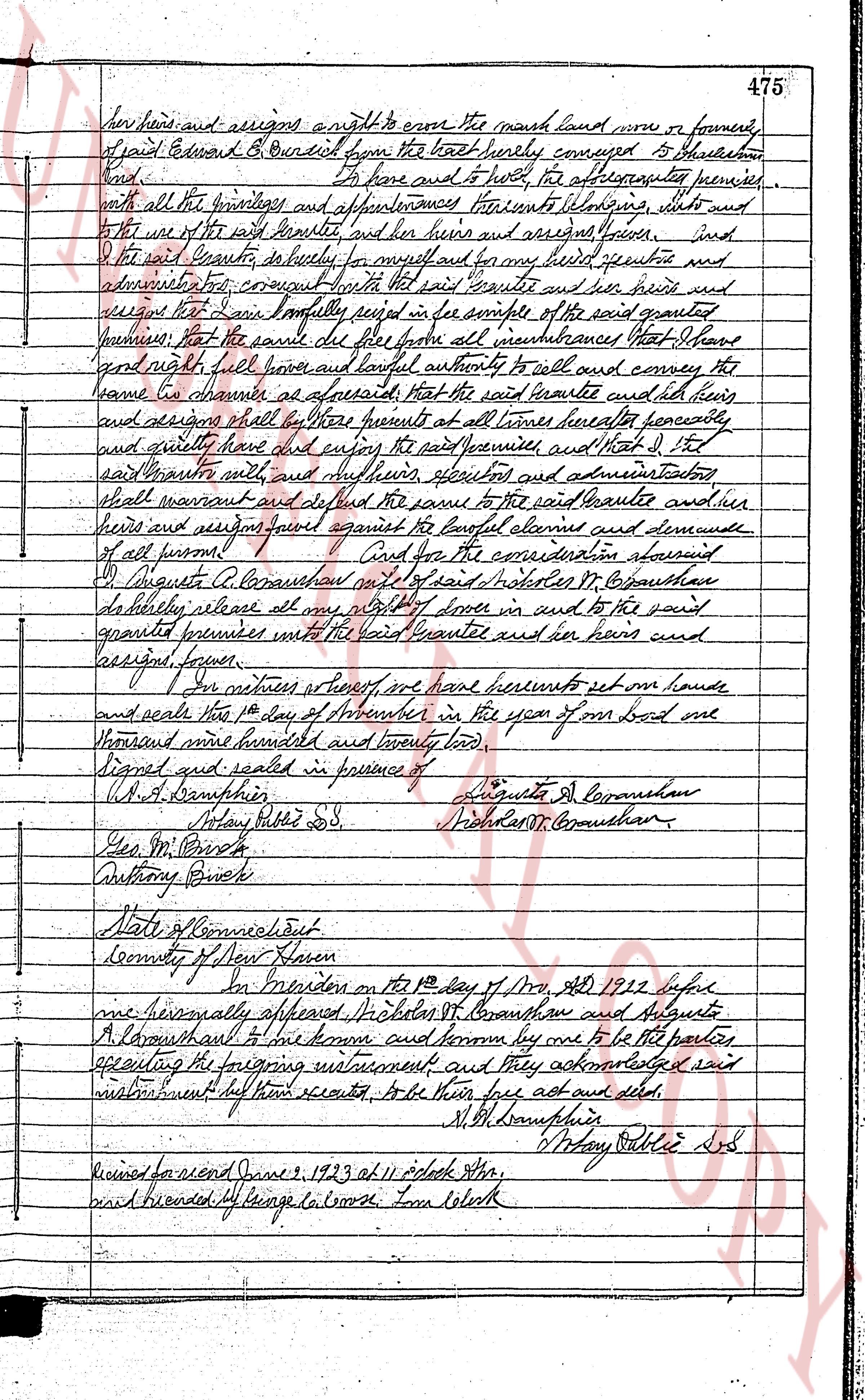
her heirs and assigns a right to enter the said land now or formerly
of said Edward B. Courtenay from the last purely conveyed to Obadiah
and. To have and to hold the aforesaid premises
with all the privileges and appurtenances belonging thereto situate and
for the use of the said Beulah and her heirs and assigns forever. And
the said Beulah, for herself for myself and for my heirs executors and
administrators first covenant with the said Courtenay and his heirs heirs and
assigns that I have lawfully seized in fee simple of the said granted
premises that the same shall be free from all incumbrances That I have
good right full power and lawful authority to sell and convey the
same to Courtenay as aforesaid That the said Courtenay and all his heirs
and assigns shall by these presents at all times hereafter peaceably
and quietly have and enjoy the said premises and that I the
said Beulah will and sufficiently execute and administrate
what warrant and defend the same to the said Courtenay and her heirs
and assigns against all lawful claims and demands
of all persons. And for the consideration aforesaid
I Augusta A. Courtenay wife of said Nicholas H. Courtenay
do hereby release all my right title and interest in and to the said
granted premises unto the said Beulah and her heirs and
assigns forever.
In witness whereof we have hereunto set our hands
and seals this 1st day of September in the year of our Lord one
thousand nine hundred and twenty two.
Signed and sealed in presence of
L.A.B. Humphries
Notary Public S.S.
Geo. M. Brick
Anthony Brick
Augusta A. Courtenay
Nicholas H. Courtenay
State of Connecticut
County of New Haven
On Friday on this 1st day of Sept AD 1922 before
me personally appeared Nicholas H. Courtenay and Augusta
A. Courtenay and declared and known by me to be the parties
executing the foregoing instrument and they acknowledged said
instrument to be their free act and deed.
L.A.B. Humphries
Notary Public S.S.
Received for record June 2, 1923 at 11 o'clock a.m.
signed & recorded At range la course From Clerk
The page as recorded