The instrument's own words
page 1
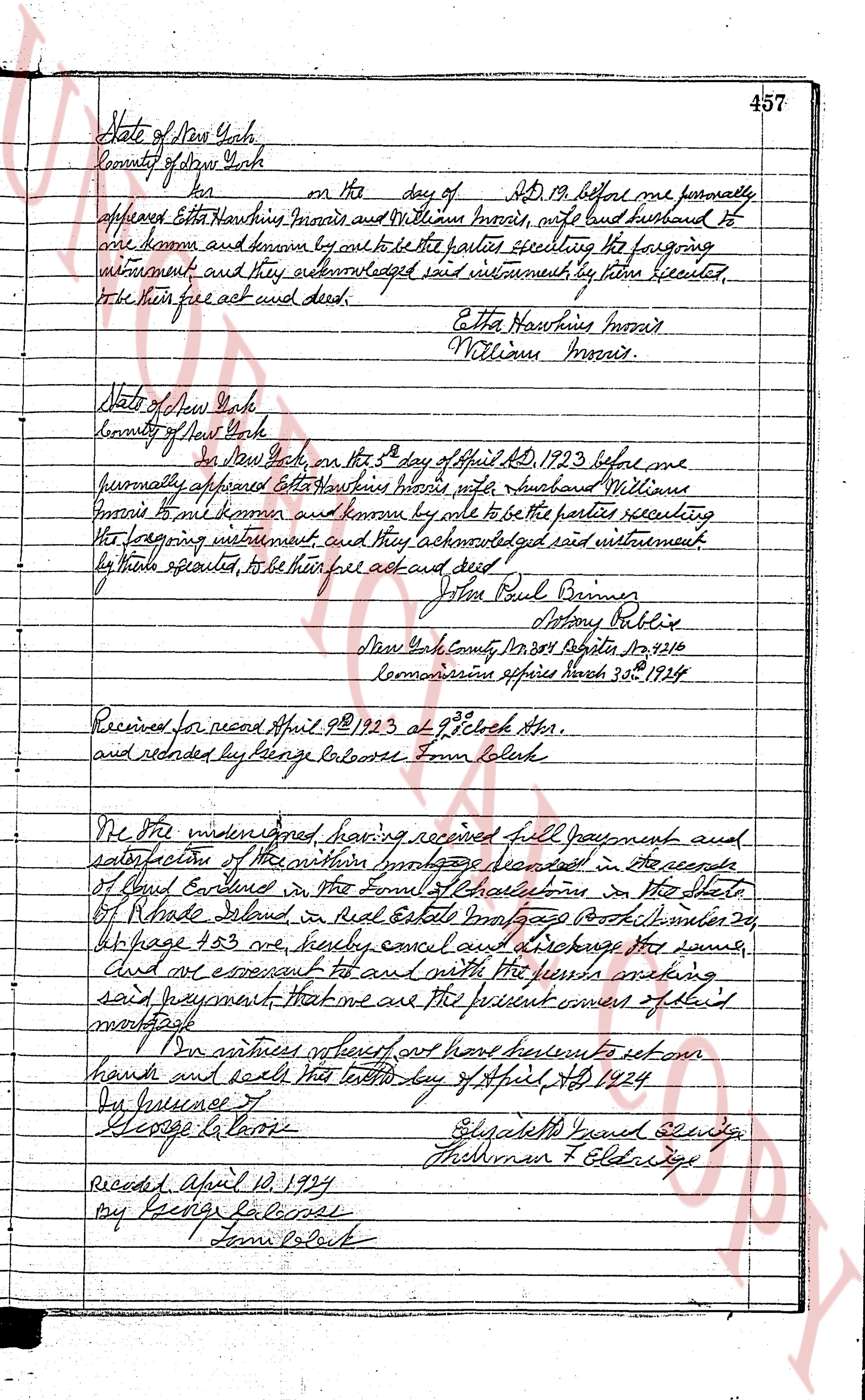
457
State of New York
County of New York
[blank] on the day of AD 19 before me formally
appeared Etta Hawkins Morris, wife and William Morris, husband and
are known and known by me to be the parties executing the foregoing
instrument and they acknowledged said instrument by them executed
to be their free act and deed.
Etta Hawkins Morris
William Morris.
State of New York
County of New York
on New York on the 5th day of April AD 1923 before me
personally appeared Etta Hawkins Morris wife and husband William
Morris to me known and known by me to be the parties executing
the foregoing instrument, and they acknowledged said instrument
by them executed, to be their free act and deed.
John Paul Barnes
Notary Public
New York County No 201 Register No 9210
Commission expires March 30, 1924
Received for record April 9th 1923 at 2 o'clock PM.
and recorded by George Latrosse Town Clerk
We the undersigned having received full payment and
satisfaction of the within mortgage recorded in the records
of East Greenwich in the Town of East Greenwich in the State
of Rhode Island, in Real Estate Mortgage Book volume 24
at page 183 no beauty, cancel and discharge the same,
and we covenant to and with the heirs nothing
said payment that we are the present owners of said
mortgage.
In witness whereof we have hereunto set our
hands and seals this tenth day of April AD 1924
By Insurance of
George G. Cope
Elizabeth Guard S. S. [illegible]
Thelma F. Eldridge
Record April 10, 1924
by George Latrosse
Town Clerk
page 2
458
HEIRS OF MARY E. BRIDGES
N 45° 44' 30" W
331.60
N 46° 55' 0" W
450.51
ADA NORRIS
N 72° 15' 0" E
20.20 ft.
S 16° 45' 0" E
390.00
ADA NORRIS
S 17° 15' 0" E
231.37
E. A. MOULTON
S 45° 40' 0" E
143.37
RICHARD H. BURDICK
SAMUEL H. DAVIS
S 20° 14' 30" W
327.76
"LOT A"
MAGNETIC
S 20° 14' 30" W
327.76
S 16° 20' 30" E
511.10
RICHARD H. BURDICK
CHARLESTOWN POND
S 16° 20' 30" E
511.10
"LOT C"
"LOT B"
ATLANTIC OCEAN
S 16° 20' 30" E
511.10
S 16° 20' 30" E
511.10
S 16° 20' 30" E
511.10
S 16° 20' 30" E
511.10
S 16° 20' 30" E
511.10
S 16° 20' 30" E
511.10
S 16° 20' 30" E
511.10
S 16° 20' 30" E
511.10
S 16° 20' 30" E
511.10
S 16° 20' 30" E
511.10
S 16° 20' 30" E
511.10
S 16° 20' 30" E
511.10
S 16° 20' 30" E
511.10
S 16° 20' 30" E
511.10
S 16° 20' 30" E
511.10
S 16° 20' 30" E
511.10
S 16° 20' 30" E
511.10
S 16° 20' 30" E
511.10
S 16° 20' 30" E
511.10
S 16° 20' 30" E
511.10
S 16° 20' 30" E
511.10
S 16° 20' 30" E
511.10
S 16° 20' 30" E
511.10
S 16° 20' 30" E
511.10
S 16° 20' 30" E
511.10
S 16° 20' 30" E
511.10
S 16° 20' 30" E
511.10
S 16° 20' 30" E
511.10
S 16° 20' 30" E
511.10
S 16° 20' 30" E
511.10
S 16° 20' 30" E
511.10
S 16° 20' 30" E
511.10
S 16° 20' 30" E
511.10
S 16° 20' 30" E
511.10
S 16° 20' 30" E
511.10
S 16° 20' 30" E
511.10
S 16° 20' 30" E
511.10
S 16° 20' 30" E
511.10
S 16° 20' 30" E
511.10
S 16° 20' 30" E
511.10
S 16° 20' 30" E
511.10
S 16° 20' 30" E
511.10
S 16° 20' 30" E
511.10
S 16° 20' 30" E
511.10
S 16° 20' 30" E
511.10
S 16° 20' 30" E
511.10
S 16° 20' 30" E
511.10
S 16° 20' 30" E
511.10
S 16° 20' 30" E
511.10
S 16° 20' 30" E
511.10
S 16° 20' 30" E
511.10
S 16° 20' 30" E
511.10
S 16° 20' 30" E
511.10
S 16° 20' 30" E
511.10
S 16° 20' 30" E
511.10
S 16° 20' 30" E
511.10
S 16° 20' 30" E
511.10
S 16° 20' 30" E
511.10
S 16° 20' 30" E
511.10
S 16° 20' 30" E
511.10
S 16° 20' 30" E
511.10
S 16° 20' 30" E
511.10
S 16° 20' 30" E
511.10
S 16° 20' 30" E
511.10
S 16° 20' 30" E
511.10
S 16° 20' 30" E
511.10
S 16° 20' 30" E
511.10
S 16° 20' 30" E
511.10
S 16° 20' 30" E
511.10
S 16° 20' 30" E
511.10
S 16° 20' 30" E
511.10
S 16° 20' 30" E
511.10
S 16° 20' 30" E
511.10
S 16° 20' 30" E
511.10
S 16° 20' 30" E
511.10
S 16° 20' 30" E
511.10
S 16° 20' 30" E
511.10
S 16° 20' 30" E
511.10
S 16° 20' 30" E
511.10
S 16° 20' 30" E
511.10
S 16° 20' 30" E
511.10
S 16° 20' 30" E
511.10
S 16° 20' 30" E
511.10
S 16° 20' 30" E
511.10
S 16° 20' 30" E
511.10
S 16° 20' 30" E
511.10
S 16° 20' 30" E
511.10
S 16° 20' 30" E
511.10
S 16° 20' 30" E
511.10
S 16° 20' 30" E
511.10
S 16° 20' 30" E
511.10
S 16° 20' 30" E
511.10
S 16° 20' 30" E
511.10
S 16° 20' 30" E
511.10
S 16° 20' 30" E
511.10
S 16° 20' 30" E
511.10
S 16° 20' 30" E
511.10
S 16° 20' 30" E
511.10
S 16° 20' 30" E
511.10
S 16° 20' 30" E
511.10
S 16° 20' 30" E
511.10
S 16° 20' 30" E
511.10
S 16° 20' 30" E
511.10
S 16° 20' 30" E
511.10
S 16° 20' 30" E
511.10
S 16° 20' 30" E
511.10
S 16° 20' 30" E
511.10
S 16° 20' 30" E
511.10
S 16° 20' 30" E
511.10
S 16° 20' 30" E
511.10
S 16° 20' 30" E
511.10
S 16° 20' 30" E
511.10
S 16° 20' 30" E
511.10
S 16° 20' 30" E
511.10
S 16° 20' 30" E
511.10
S 16° 20' 30" E
511.10
S 16° 20' 30" E
511.10
S 16° 20' 30" E
511.10
S 16° 20' 30" E
511.10
S 16° 20' 30" E
511.10
S 16° 20' 30" E
511.10
S 16° 20' 30" E
511.10
S 16° 20' 30" E
511.10
S 16° 20' 30" E
511.10
S 16° 20' 30" E
511.10
S 16° 20' 30" E
511.10
S 16° 20' 30" E
511.10
S 16° 20' 30" E
511.10
S 16° 20' 30" E
511.10
S 16° 20' 30" E
511.10
S 16° 20' 30" E
511.10
S 16° 20' 30" E
511.10
The page as recorded