The instrument's own words
page 1 · read by Gemma vision
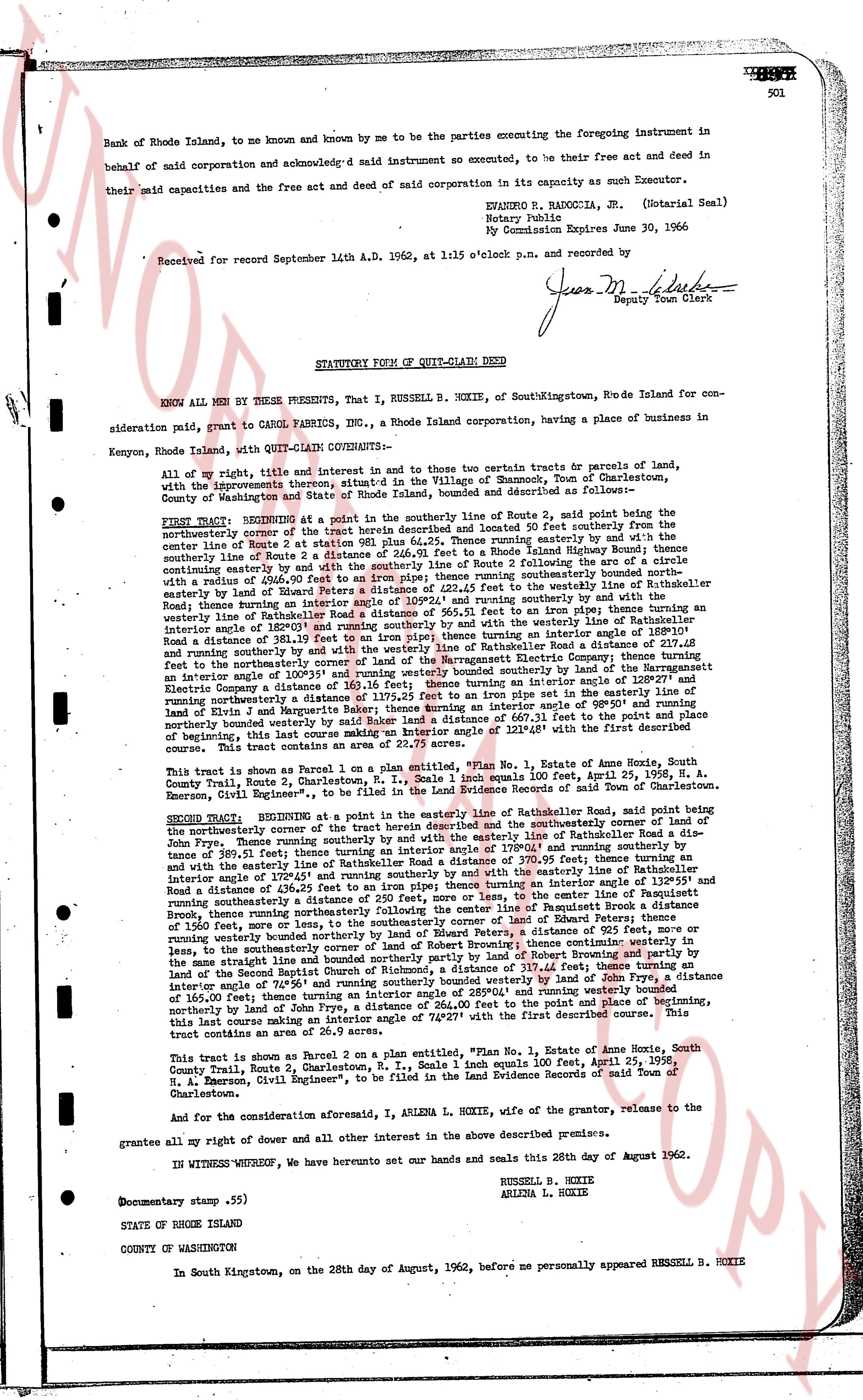
501
Bank of Rhode Island, to me known and by me known to be the parties executing the foregoing instrument in
behalf of said corporation and acknowledg'd said instrument so executed, to be their free act and deed in
behalf of said corporation and the free act and deed of said corporation in its capacity as such Executor.
their said capacities and the free act and deed of said corporation in its capacity as such Executor.
EVANXRO H. BANCOLA, JR. (Notarial Seal)
Notary Public
My Commission Expires June 30, 1966
Received for record September 14th A.D. 1962, at 1:15 o'clock p.m. and recorded by
Jesus M. [?]
Deputy Town Clerk
----
STATUTORY FORM OF QUIT-CLAIM DEED
KNOW ALL MEN BY THESE PRESENTS, That I, RUSSELL B. HOXIE, of SouthKingstown, RI-de Island for con-
sideration paid, grant to CAROL FABRICS INC., a Rhode Island corporation, having a place of business in
Kenyon, Rhode Island, with QUIT-CLAIM COVENANTS--
All of my right, title and interest in and to those two certain tracts or parcels of land,
with the buildings thereon, situated in the Village of Shannock, Town of Charlestown,
County of Washington and State of Rhode Island, bounded and described as follows:
FIRST TRACT: BEGINNING at a point in the southerly line of Route 2, said point being the
northwesterly corner of the said southerly line of Route 2, located 40 feet southerly from the
center line of Route 2 at station 981 plus 64.25, 235. those running easterly by and with the
southerly line of Route 2 to a point in the southerly line of Rhode Island Highway Route 2, thence running
continuing easterly by and with the southerly line of Route 2 following the arc of a circle
with a radius of 240.00 feet and a chord distance of 230.58 feet running southerly bounded by the arc of a
circle by land of Edward Peters a distance of 222.45 feet to the westerly line of Rathkoller Road as
westerly line of Rathkoller Road a distance of 100.00 feet, thence turning an interior angle of 128°27'
Road thence running in an easterly direction a distance of 565.11 feet to an iron pipe, thence turning an
interior angle of 182°01' and running southerly along the northerly line of the northerly lot of the
Road a distance of 318.40 feet to an iron pipe, thence turning an interior angle of 128°10' and running
southerly by and with the westerly line of the northerly lot of the Rhode Island Electric Company, thence turning
an interior angle of 81°14' and running easterly by and with the northerly line of the southerly lot of the
Electric Company, a distance of 318.40 feet to an iron pipe, thence turning an interior angle of 128°27' and
running northerly a distance of 115.25 feet to an iron pipe set in the easterly line of the southerly lot of
the Electric Company, thence turning an interior angle of 58°12' and running easterly a distance of 660.31 feet to the
point of beginning, northerly bounded west by a land of [?] a distance of 1194.61 feet the First described tract.
This tract contains an area of 22.27 acres.
This tract is shown as Parcel 1 on a plan entitled, "Plan No. 1, Estate of Annie Hoox, South
County Trail, Route 2, Charlestown, R. I., Scale 1 inch equals 100 feet, April 25, 1958, R.
A. [?], Civil Engineer", to be filed in the Land Evidence Records of said Town of Charlestown.
SECOND TRACT: BEGINNING at a point in the easterly line of Rathkoller Road, said point being the
northwesterly corner of the said tract the herein described, thence running easterly along the easterly line of Rathkoller Road a dis-
tance of 299.75 feet, thence turning an interior angle of 135°15' and running southerly a distance of
189.51 feet, thence turning an interior angle of 125°15' and running southerly a distance of 390.75 feet, thence turning an
interior angle of 125°15' and running southerly by and with the center line of the southerly line of
Road a distance of 118.61 feet, thence turning an interior angle of 135°15' and running southerly to the
center line of Route 2 at station 981 plus 64.25, thence running southerly a distance of 250 feet, more or less, to the
center line of Route 2 at station 981 plus 114.25, thence running southerly a distance of 250 feet, more or
less, to the southerly corner of land of Edward Peters; thence running southerly by and with the
southerly line of Route 2 a distance of 230.58 feet, thence running southerly a distance of 250 feet, more or
less, to the southerly corner of land of Robert Browning; thence continuing westerly in
the same straight line and bounded northerly parcels of [?] a distance of 317.41 feet, thence turning an
interior angle of 128°10' and running northerly a distance of 318.40 feet to an iron pipe, thence turning an interior
angle of 58°24' and running southerly bounded northerly by land of [?] a distance of 115.25 feet, thence
of 160.00 feet, thence turning an interior angle of 28°04' and running westerly bounded
northerly by land of John Dye, a distance of 624.00 feet to the point of place of beginning,
this tract being marked as Parcel 2 on the plan aforesaid and the first described corner. This
tract contains an area of 26.9 acres.
This tract is shown as Parcel 2 on a plan entitled, "Plan No. 1, Estate of Annie Hoox, South
County Trail, Route 2, Charlestown, R. I., Scale 1 inch equals 100 feet, April 25, 1958, R.
A. [?], Civil Engineer", to be filed in the Land Evidence Records of said Town of
Charlestown.
And for the consideration aforesaid, I, ARLENA L. HOXIE, wife of the grantor, release to the
grantee all my right of dower and all other interest in the above described premises.
IN WITNESS WHEREOF, we have hereunto set our hands and seals this 28th day of August 1962.
RUSSELL B. HOXIE
ARLENA L. HOXIE
Documentary stamp .55)
STATE OF RHODE ISLAND
COUNTY OF WASHINGTON
In South Kingstown, on the 28th day of August, 1962, before me personally appeared RUSSELL B. HOXIE
page 2 · read by Gemma vision
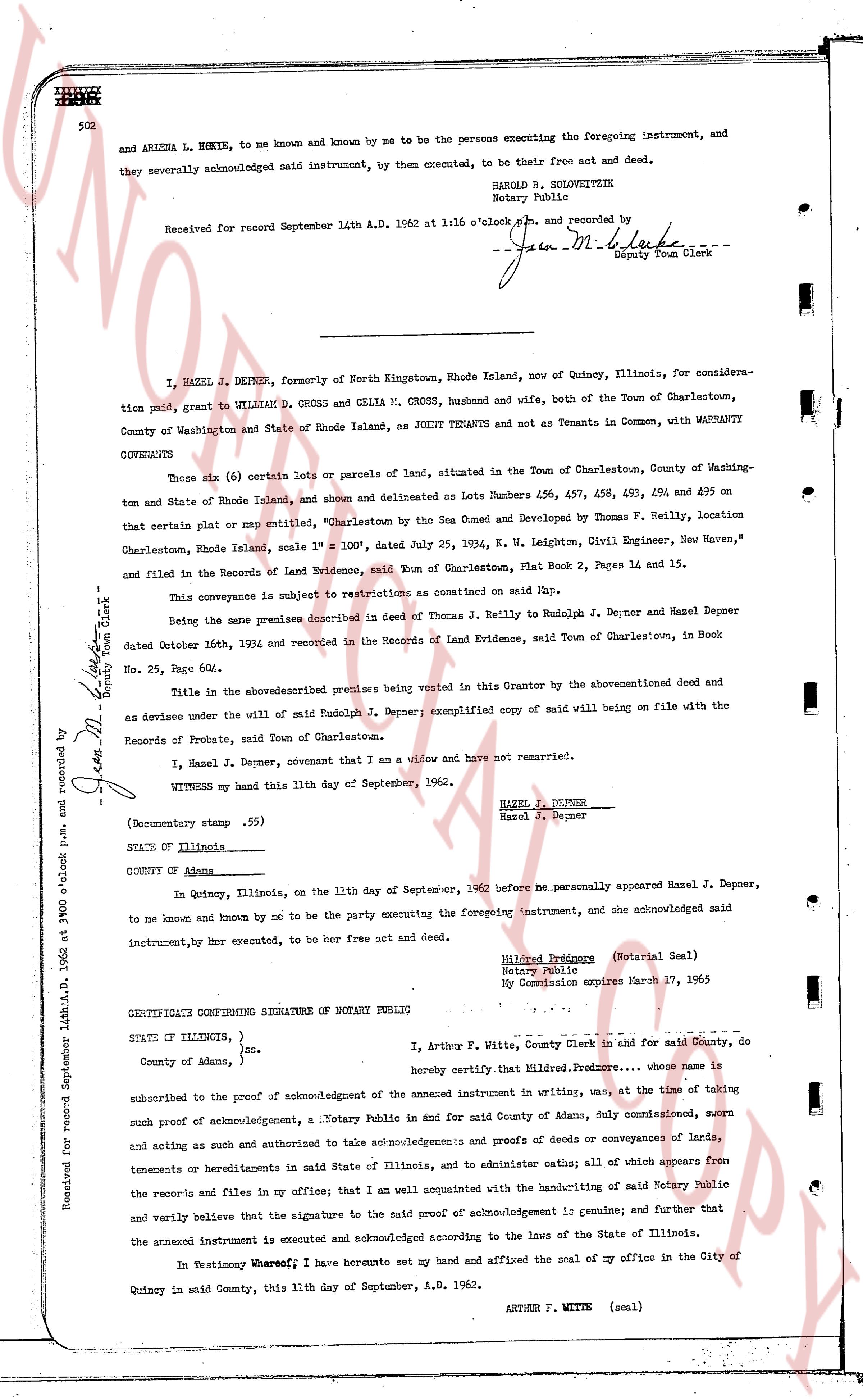
502 and ARLENA L. HOXIE, to me known and known by me to be the persons executing the foregoing instrument, and they severally acknowledged said instrument, by them executed, to be their free act and deed.
HAROLD B. SOLOWIEZNIK
Notary Public
Received for record September 14th A.D. 1962 at 1:16 o'clock p.m. and recorded by /s/ Gen M. Black
Deputy Town Clerk
----
I, HAZEL J. DEPNER, formerly of North Kingstown, Rhode Island, now of Quincy, Illinois, for consideration paid, grant to WILLIAM D. CROSS and CELIA M. CROSS, husband and wife, both of the Town of Charlestown, County of Washington and State of Rhode Island, as JOINT TENANTS and not as Tenants in Common, with WARRANTY COVENANTS
Those six (6) certain lots or parcels of land, situated in the Town of Charlestown, County of Washington and State of Rhode Island, and shown and delineated as Lots Numbers 456, 457, 458, 459, 460 and 495 on that certain plat or map entitled, "Charlestown by the Sea Owned and Developed by Thomas F. Reilly, location Charlestown, Rhode Island, scale 1" = 100'", dated July 25, 1954, K. W. Leighton, Civil Engineer, New Haven", and filed in the Records of Land Evidence, said Town of Charlestown, Plat Book 2, Pages 1 and 15.
This conveyance is subject to restrictions as contained on said Map.
Being the same premises described in deed of Thomas J. Reilly to Rudolph J. Depner and Hazel Depner dated October 16th, 1944, and recorded in the Records of Land Evidence, said Town of Charlestown, in Book No. 25, Page 604.
Title in the above described premises being vested in this Grantor by the aforementioned deed and as devisee under the will of said Rudolph J. Depner; exemplified copy of said will being on file with the Records of Probate, said Town of Charlestown.
I, Hazel J. Depner, covenant that I am a widow and have not remarried.
WITNESS my hand this 11th day of September, 1962.
Hazel J. Depner
Hazel J. Depner
(Documentary stamp .55)
STATE of Illinois
COUNTY of Adams
In Quincy, Illinois, on the 11th day of September, 1962 before me personally appeared Hazel J. Depner, to me known and known by me to be the party executing the foregoing instrument, and she acknowledged said instrument, by her executed, to be her free act and deed.
Mildred Pederson (Notarial Seal)
Notary Public
My Commission expires March 27, 1965
CERTIFICATE CONFIRMING SIGNATURE OF NOTARY PUBLIC
STATE of ILLINOIS, }
County of Adams, } ss.
I, Arthur F. Witte, County Clerk and in said County, do hereby certify that, Mildred Pederson... whose name is subscribed to the proof of acknowledgement of the annexed instrument in writing, was, at the time of taking such proof of acknowledgement, a Notary Public in and for said County of Adams, duly commissioned, sworn and acting as such and authorized to take acknowledgements and proofs of deeds or conveyances of lands, tenements or hereditaments in said State of Illinois, and to administer oaths; all of which appears from the records and files in my office; that I am well acquainted with the handwriting of said Notary Public and verily believe that the signature to the said proof of acknowledgement is genuine; and further that the annexed instrument is executed and acknowledged according to the laws of the State of Illinois.
In Testimony Whereof, I have hereunto set my hand and affixed the seal of my office in the City of Quincy in said County, this 11th day of September, A.D. 1962.
ARTHUR F. WITTE (seal)
Received for record September 14th A.D. 1962 at 9 o'clock p.m. and recorded by /s/ Gen M. Black
Deputy Town Clerk
The page as recorded