The instrument's own words
page 1 · read by Gemma vision
480
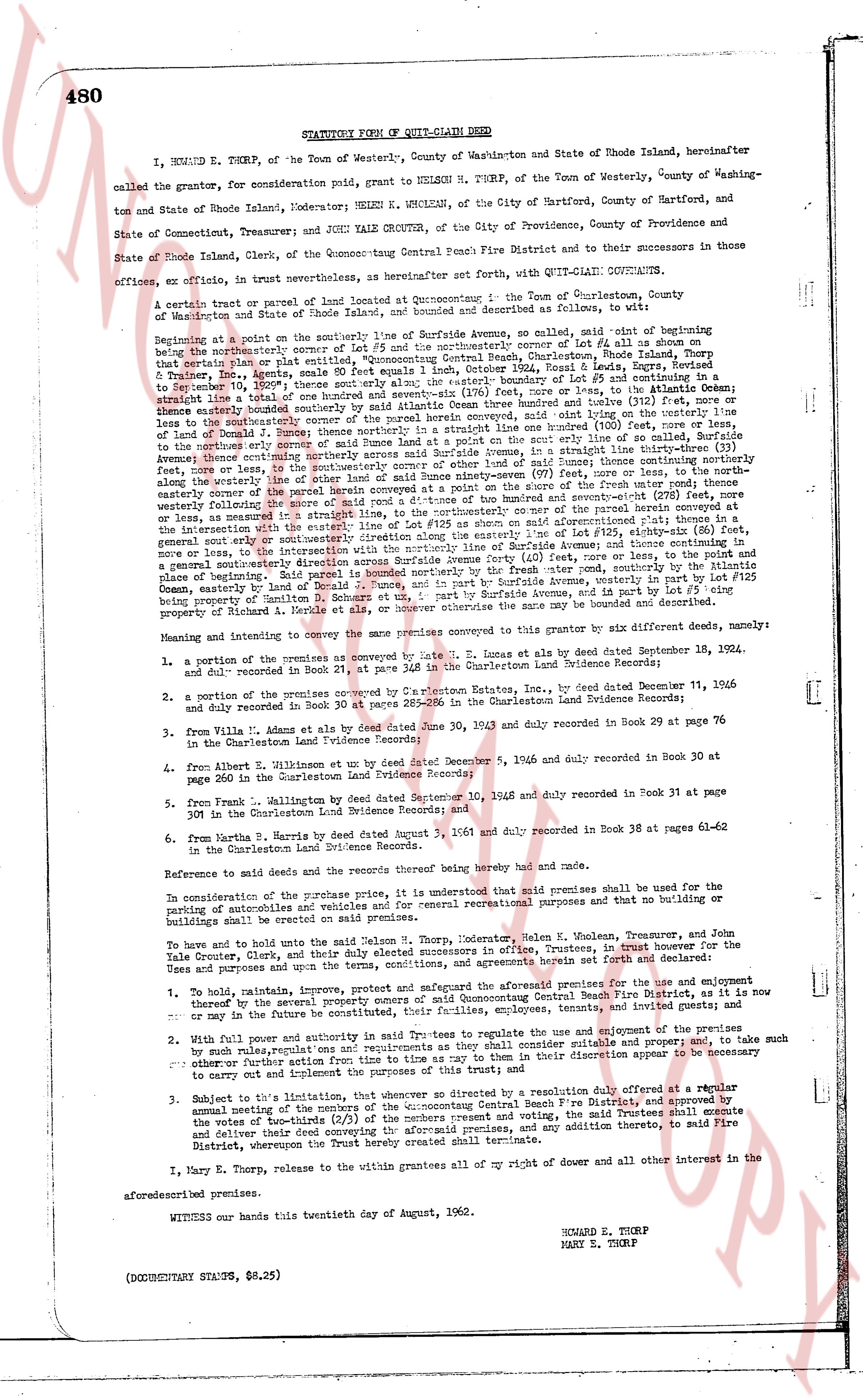
STATUTORY FORM OF QUIT-CLAIM DEED
I, HOWARD E. THORP, of the Town of Westerly, County of Washington and State of Rhode Island, hereinafter called the grantor, for consideration paid, grant to NELSON H. THORP, of the Town of Westerly, County of Washington and State of Rhode Island, Moderator; HELEN K. WHOLEAN, of the City of Hartford, County of Hartford, and State of Connecticut; and JOHN YALE CROUTER, of the City of Providence, County of Providence and State of Rhode Island, Clerk, of the Quonocontaug Central Beach Fire District and to their successors in those offices, office, in trust nevertheless, as hereinafter set forth with, QUIT-CLAIM CONVEYANCE.
A certain tract or parcel of land located at Quonocontaug in the Town of Charlestown, County of Washington and State of Rhode Island, more or less [?] acres, described as follows: To wit, it begins at
Beginning at a point on the southerly course line of Surfside Avenue, so called, said point being at the bearing intersection of the northerly course line of Lot #25 and the northerly course line of Lot #4 as shown on that certain plat or map entitled, "Quonocontaug Central Beach, Charlestown, Rhode Island" dated June 1, 1936, recorded in Book 341, page 104 of the Charlestown Land Evidence Records, [?] from the easterly line of Lot #4 as shown on said plat, and running thence south east by north 10 1/2 degrees to September 10, 1959; thence south east by north the aforesaid course 115.5 feet, more or less, to the Atlantic Ocean; thence along the south westerly shore line of said Ocean to a point on the westerly line of Lot #39 as shown on the aforesaid plat; thence easterly boundary所述 by said Atlantic Ocean thence north westerly 110 feet, said point lying on the westerly line of Lot #39 aforesaid; thence northerly in a straight line one hundred (100) feet, to the westerly line of said Surfside Avenue; thence continuing northerly across said Surfside Avenue, in a straight line thirty three (33) feet, more or less, to the north westerly line of Lot #25 as shown on the aforesaid plat; thence running easterly along the westerly line of lot #25 of said ninety seven (97) feet, more or less, to the north westerly line of Lot #24 as shown on the aforesaid plat; thence running northerly along the north westerly boundary following the line of more or less a rod distance of the ubuntu on said aforementioned plat thence in a most general south east or south westerly direction along the line of Lot #25 as shown on said plat; thence running in a general south east or south westerly direction along the line of Surfside Avenue and thence continuing in most general south east or south westerly direction to the north westerly line of fresh water pond, southerly by the Atlantic Ocean, easterly by land of Donald R. Bunce, and in part by Surfside Avenue, and in part by lot #3 lying in property of Beatrice A. Merkle et al, or however otherwise the same may be bounded and described.
And conveying and transferring to and conveying the same premises conveyed to this grantor by six different deeds, namely:
1. a portion of the premises as conveyed by L. E. Jonas et al by deed dated September 18, 1934, and duly recorded in Book 21, page 34 of the Charlestown Land Evidence Records;
2. a portion of the premises conveyed by L. E. Jonas et al, by deed dated November 11, 1936 and duly recorded in Book 34, page 285-286 in the Charlestown Land Evidence Records;
3. from V. Villa et al by deed dated June 30, 1943 and duly recorded in Book 29 at page 76 in the Charlestown Land Evidence Records;
4. from Albert B. Wilkinson et ux by deed dated December 5, 1946 and duly recorded in Book 30 at page 260 in the Charlestown Land Evidence Records;
5. from L. Hallington by deed dated September 10, 1948 and duly recorded in Book 31 at page 309 in the Charlestown Land Evidence Records; and
6. from Martha B. Norris by deed dated August 3, 1961 and duly recorded in Book 38 at pages 61-62 in the Charlestown Land Evidence Records.
Reference to said deeds and the records thereof being hereby had and made.
In consideration of the purchase price paid, it is understood that said premises shall be used for the purpose of protection of swimmers and recreation and general recreational purposes and that no building or buildings shall be erected on said premises.
To have and to hold and to use said Nelson H. Thorp, Moderator, Helen K. Wholean, Treasurer, and John Yale Crouter, Clerk, and their successors in said offices, in trust, for the Trustees of the Quonocontaug Central Beach Fire District, and their successors in office, in trust, for the uses and purposes and upon the terms, conditions, and agreements herein set forth and declared:
1. To hold, maintain, improve, protect and safeguard the aforementioned premises for the use and enjoyment thereof by the general public, and for the purpose of protection of swimmers and recreation, and it is now or may in the future be conducted, their employees, tenants, invitees and guests of the premises; and
2. With full power and authority as said Trustees to regulate the use and enjoyment of the premises by such rules, regulations and restrictions as they may deem suitable and proper, and to make such other bylaws pertaining to said premises as time as may be from time in their discretion appear to be necessary to carry out and implement the purposes of this trust; and
3. Subject to the limitation, that whenever so directed by a resolution duly adopted at a regular annual meeting of the members of the Quonocontaug Central Beach Fire District, and approved by the vote of the two-thirds (2/3) of the members present and voting, said Trustees shall execute and deliver a deed conveying said premises, with or without any addition thereto, to said Fire District, whereupon the Trust hereby created shall terminate.
I, Mary E. Thorp, release to the within grantees all of my right and other interest in the aforesaid described premises.
WITNESS our hands this twentyfourth day of August, 1962.
HOWARD E. THORP
MARY E. THORP
(DOCUMENTARY STAMPS, $6.25)
page 2 · read by Gemma vision
481
STATE OF RHODE ISLAND
COUNTY OF WASHINGTON
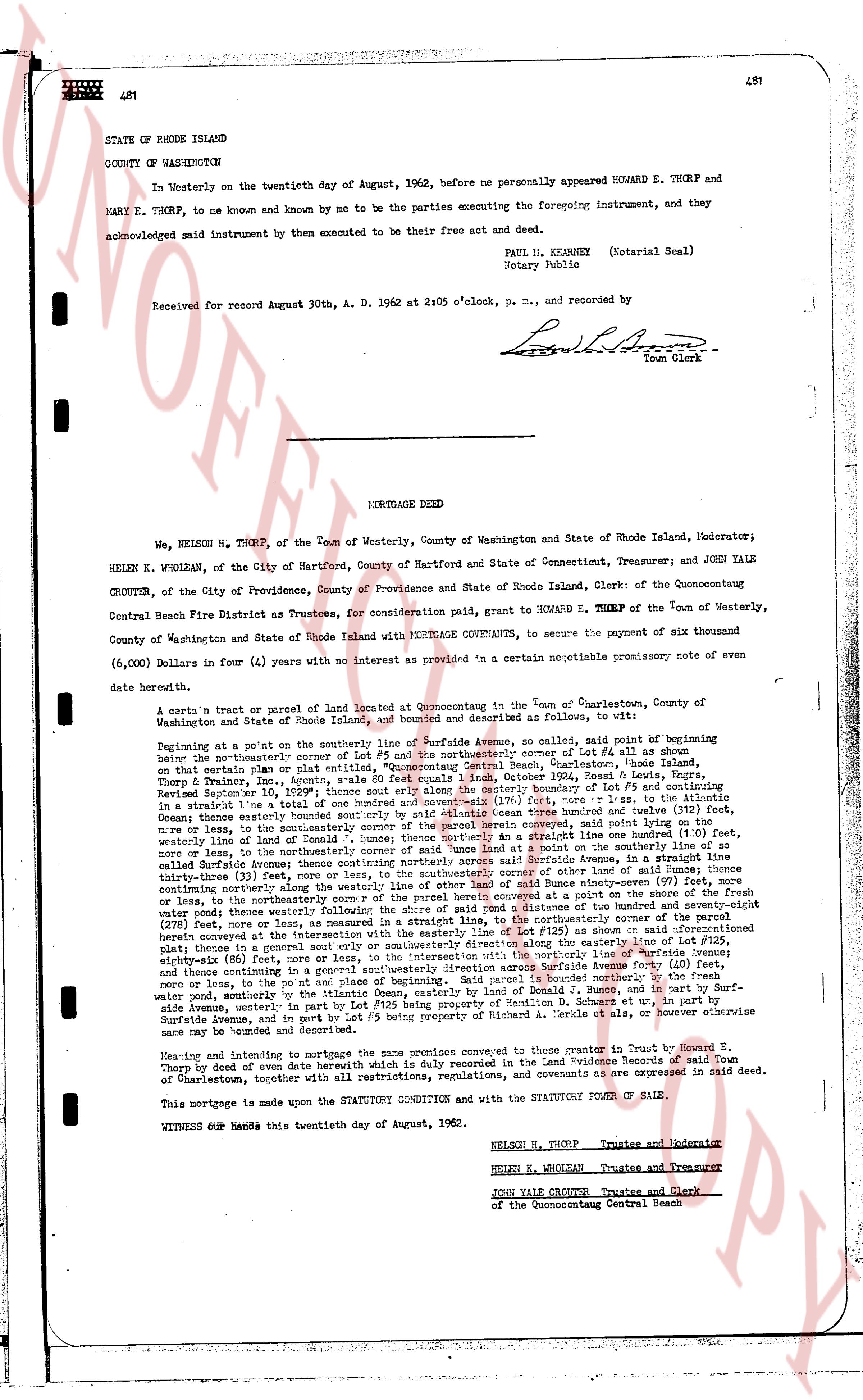
In Westerly on the twentieth day of August, 1962, before me personally appeared HOWARD E. THORP and MARY E. THORP, to me known and by me to be the parties executing the foregoing instrument, and they acknowledged said instrument by them to be their free act and deed.
PAUL H. KEANEY (Notarial Seal)
Notary Public
Received for record August 30th, A. D. 1962 at 2:05 o'clock, P. M., and recorded by
[Signature]
Town Clerk
----
MORTGAGE DEED
We, NELSON H. THORP, of the town of Westerly, County of Washington and State of Rhode Island, Moderator; HELEN K. WHOLEAN, of the City of Hartford, County of Hartford and State of Connecticut, Treasurer; and JOHN YALE CROUTER, of the City of Providence, County of Providence and State of Rhode Island, Clerk: of the Quonocontaug Central Beach Fire District as Trustees, for consideration paid, grant to HOWARD E. THORP of the town of Westerly, County of Washington and State of Rhode Island with MORTGAGE COVENANTS, to secure the payment of six thousand (6,000) Dollars in four (4) years with no interest provided as in a certain describable promissory note of even date herewith.
A certain's tract or parcel of land located at Quonocontaug in the town of Charlestown, County of Washington and State of Rhode Island, bounded and described as follows, to all suits:
Beginning at a point on the southeasterly line of Surfside Avenue, so called, said point of beginning being on the northeasterly corner of a parcel of land described in the record copy of Lot #5 as shown on that certain plan or plat entitled, "Quonocontaug Central Beach, Charlestown, Rhode Island, showing Boundary Lines, Areas and Owners" dated June 1, 1936, Book 332, page 480, filed September 10, 1936; thence south east 1/2" thence easterly along the easterly boundary of Lot #5 and continuing thence southeasterly along the easterly boundary of Lot #4 as shown on said plan, in a straight line to a straight line toe of a total measure of one hundred (100) feet, more or less, thence southeasterly along the easterly boundary of said instrument by said distance (Ocean three hundred & twelve (312) feet, Ocean three hundred twenty three (323) feet, in a straight line one hundred (100) feet, variance line of land of [?] [?] [?] [?] [?] [?] [?] [?] [?] [?] [?] [?] [?] [?] [?] [?] [?] [?] [?] [?] [?] [?] [?] [?] [?] [?] [?] [?] [?] [?] [?] [?] [?] [?] [?] [?] [?] [?] [?] [?] [?] [?] [?] [?] [?] [?] [?] [?] [?] [?] [?] [?] [?] [?] [?] [?] [?] [?] [?] [?] [?] [?] [?] [?] [?] [?] [?] [?] [?] [?] [?] [?] [?] [?] [?] [?] [?] [?] [?] [?] [?] [?] [?] [?] [?] [?] [?] [?] [?] [?] [?] [?] [?] [?] [?] [?] [?] [?] [?] [?] [?] [?] [?] [?] [?] [?] [?] [?] [?] [?] [?] [?] [?] [?] [?] [?] [?] [?] [?] [?] [?] [?] [?] [?] [?] [?] [?] [?] [?] [?] [?] [?] [?] [?] [?] [?] [?] [?] [?] [?] [?] [?] [?] [?] [?] [?] [?] [?] [?] [?] [?] [?] [?] [?] [?] [?] [?] [?] [?] [?] [?] [?] [?] [?] [?] [?] [?] [?] [?] [?] [?] [?] [?] [?] [?] [?] [?] [?] [?] [?] [?] [?] [?] [?] [?] [?] [?] [?] [?] [?] [?] [?] [?] [?] [?] [?] [?] [?] [?] [?] [?] [?] [?] [?] [?] [?] [?] [?] [?] [?] [?] [?] [?] [?] [?] [?] [?] [?] [?] [?] [?] [?] [?] [?] [?] [?] [?] [?] [?] [?] [?] [?] [?] [?] [?] [?] [?] [?] [?] [?] [?] [?] [?] [?] [?] [?] [?] [?] [?] [?] [?] [?] [?] [?] [?] [?] [?] [?] [?] [?] [?] [?] [?] [?] [?] [?] [?] [?] [?] [?] [?] [?] [?] [?] [?] [?] [?] [?] [?] [?] [?] [?] [?] [?] [?] [?] [?] [?] [?] [?] [?] [?] [?] [?] [?] [?] [?] [?] [?] [?] [?] [?] [?] [?] [?] [?] [?] [?] [?] [?] [?] [?] [?] [?] [?] [?] [?] [?] [?] [?] [?] [?] [?] [?] [?] [?] [?] [?] [?] [?] [?] [?] [?] [?] [?] [?] [?] [?] [?] [?] [?] [?] [?] [?] [?] [?] [?] [?] [?] [?] [?] [?] [?] [?] [?] [?] [?] [?] [?] [?] [?] [?] [?] [?] [?] [?] [?] [?] [?] [?] [?] [?] [?] [?] [?] [?] [?] [?] [?] [?] [?] [?] [?] [?] [?] [?] [?] [?] [?] [?] [?] [?] [?] [?] [?] [?] [?] [?] [?] [?] [?] [?] [?] [?] [?] [?] [?] [?] [?] [?] [?] [?] [?] [?] [?] [?] [?] [?] [?] [?] [?] [?] [?] [?] [?] [?] [?] [?] [?] [?] [?] [?] [?] [?] [?] [?] [?] [?] [?] [?] [?] [?] [?] [?] [?] [?] [?] [?] [?] [?] [?] [?] [?] [?] [?] [?] [?] [?] [?] [?] [?] [?] [?] [?] [?] [?] [?] [?] [?] [?] [?] [?] [?] [?] [?] [?] [?] [?] [?] [?] [?] [?] [?] [?] [?] [?] [?] [?] [?] [?] [?] [?] [?] [?] [?] [?] [?] [?] [?] [?] [?] [?] [?] [?] [?] [?] [?] [?] [?] [?] [?] [?] [?] [?] [?] [?] [?] [?] [?] [?] [?] [?] [?] [?] [?] [?] [?] [?] [?] [?] [?] [?] [?] [?] [?] [?] [?] [?] [?] [?] [?] [?] [?] [?] [?] [?] [?] [?] [?] [?] [?] [?] [?] [?] [?] [?] [?] [?] [?] [?] [?] [?] [?] [?] [?] [?] [?] [?] [?] [?] [?] [?] [?] [?] [?] [?] [?] [?] [?] [?] [?] [?] [?] [?] [?] [?] [?] [?] [?] [?] [?] [?] [?] [?] [?] [?] [?] [?] [?] [?] [?] [?] [?] [?] [?] [?] [?] [?] [?] [?] [?] [?] [?] [?] [?] [?] [?] [?] [?] [?] [?] [?] [?] [?] [?] [?] [?] [?] [?] [?] [?] [?] [?] [?] [?] [?] [?] [?] [?] [?] [?] [?] [?] [?] [?] [?] [?] [?] [?] [?] [?] [?] [?] [?] [?] [?] [?] [?] [?] [?] [?] [?] [?] [?] [?] [?] [?] [?] [?] [?] [?] [?] [?] [?] [?] [?] [?] [?] [?] [?] [?] [?] [?] [?] [?] [?] [?] [?] [?] [?] [?] [?] [?] [?] [?] [?] [?] [?] [?] [?] [?] [?] [?] [?] [?] [?] [?] [?] [?] [?] [?] [?] [?] [?] [?] [?] [?] [?] [?] [?] [?] [?] [?] [?] [?] [?] [?] [?] [?] [?] [?] [?] [?] [?] [?] [?] [?] [?] [?] [?] [?] [?] [?] [?] [?] [?] [?] [?] [?] [?] [?] [?] [?] [?] [?] [?] [?] [?] [?] [?] [?] [?] [?] [?] [?] [?] [?] [?] [?] [?] [?] [?] [?] [?] [?] [?] [?] [?] [?] [?] [?] [?] [?] [?] [?] [?] [?] [?] [?] [?] [?] [?] [?] [?] [?] [?] [?] [?] [?] [?] [?] [?] [?] [?] [?] [?] [?] [?] [?] [?] [?] [?] [?] [?] [?] [?] [?] [?] [?] [?] [?] [?] [?] [?] [?] [?] [?] [?] [?] [?] [?] [?] [?] [?] [?] [?] [?] [?] [?] [?] [?] [?] [?] [?] [?] [?] [?] [?] [?] [?] [?] [?] [?] [?] [?] [?] [?] [?] [?] [?] [?] [?] [?] [?] [?] [?] [?] [?] [?] [?] [?] [?] [?] [?] [?] [?] [?] [?] [?] [?] [?] [?] [?] [?] [?] [?] [?] [?] [?] [?] [?] [?] [?] [?] [?] [?] [?] [?] [?] [?] [?] [?] [?] [?] [?] [?] [?] [?] [?] [?] [?] [?] [?] [?] [?] [?] [?] [?] [?] [?] [?] [?] [?] [?] [?] [?] [?] [?] [?] [?] [?] [?] [?] [?] [?] [?] [?] [?] [?] [?] [?] [?] [?] [?] [?] [?] [?] [?] [?] [?] [?] [?] [?] [?] [?] [?] [?] [?] [?] [?] [?] [?] [?] [?] [?] [?] [?] [?] [?] [?] [?] [?] [?] [?] [?] [?] [?] [?] [?] [?] [?] [?] [?] [?] [?] [?] [?] [?] [?] [?] [?] [?] [?] [?] [?] [?] [?] [?] [?] [?] [?] [?] [?] [?] [?] [?] [?] [?] [?] [?] [?] [?] [?] [?] [?] [?] [?] [?] [?] [?] [?] [?] [?] [?] [?] [?] [?] [?] [?] [?] [?] [?] [?] [?] [?] [?] [?] [?] [?] [?] [?] [?] [?] [?] [?] [?] [?] [?] [?] [?] [?] [?] [?] [?] [?] [?] [?] [?] [?] [?] [?] [?] [?] [?] [?] [?] [?] [?] [?] [?] [?] [?] [?] [?] [?] [?] [?] [?] [?] [?] [?] [?] [?] [?] [?] [?] [?] [?] [?] [?] [?] [?] [?] [?] [?] [?] [?] [?] [?] [?] [?] [?] [?] [?] [?] [?] [?] [?] [?] [?] [?] [?] [?] [?] [?] [?] [?] [?] [?] [?] [?] [?] [?] [?] [?] [?] [?] [?] [?] [?] [?] [?] [?] [?] [?] [?] [?] [?] [?] [?] [?] [?] [?] [?] [?] [?] [?] [?] [?] [?] [?] [?] [?] [?] [?] [?] [?] [?] [?] [?] [?] [?] [?] [?] [?] [?] [?] [?] [?] [?] [?] [?] [?] [?] [?] [?] [?] [?] [?] [?] [?] [?] [?] [?] [?] [?] [?] [?] [?] [?] [?] [?] [?] [?] [?] [?] [?] [?] [?] [?] [?] [?] [?]
The page as recorded