The instrument's own words
page 1 · read by Gemma vision
417
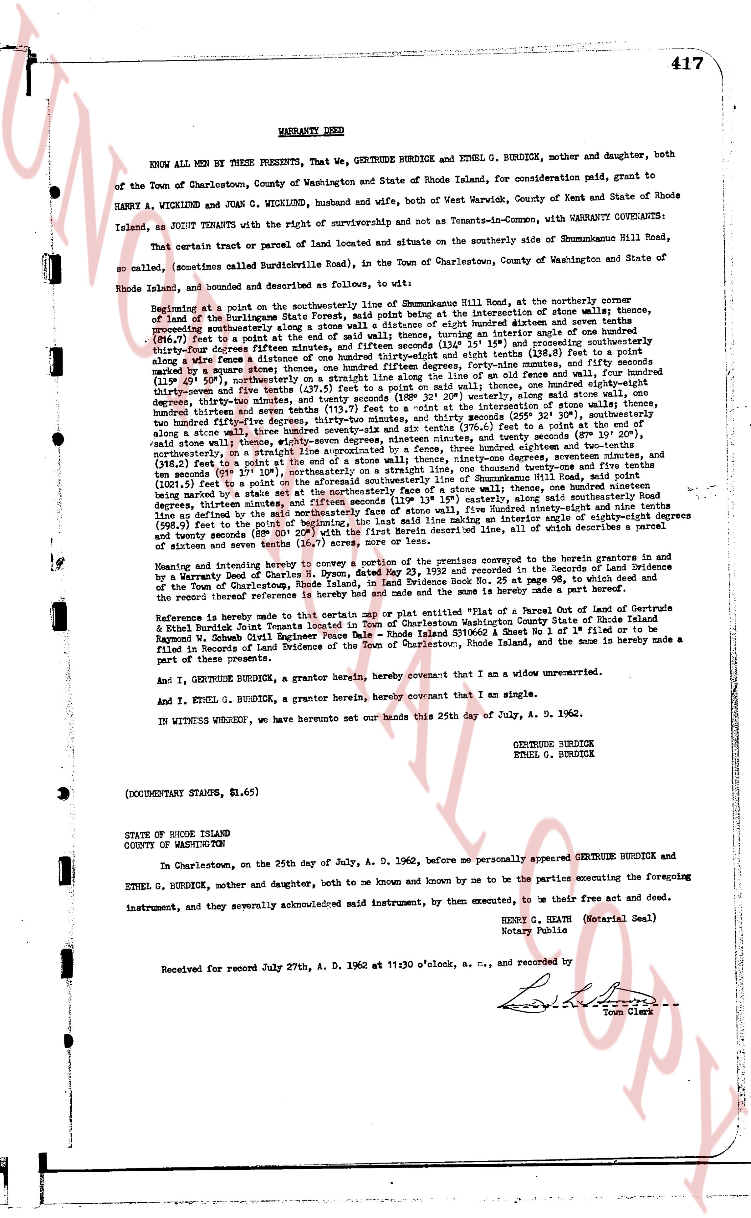
WARRANTY DEED
KNOW ALL MEN BY THESE PRESENTS, That We, GERTRUDE BURDICK and ETHEL G. BURDICK, mother and daughter, both of the Town of Charlestown, County of Washington and State of Rhode Island, for consideration paid, grant to HARRY A. WICKLUND and JOAN C. WICKLUND, husband and wife, both of West Warwick, County of Kent and State of Rhode Island, as JOINT TENANTS with the right of survivorship and not as Tenants-in-Common, with WARRANTY COVENANTS:
That certain parcel or tract of parcel of land located and situate on the southerly side of Shummnewline Hill Road, so called, (sometimes called Burdicksville Road), in the Town of Charlestown, County of Washington and State of Rhode Island, and bounded and described as follows, to wit:
Beginning at a point on the southerly line of the southerly side of Shummnewline Hill Road, at the northerly corner over of land of the Burdickstate State Forest, said point being at the intersection of phone wires; thence, proceeding southeasterly along said southerly line of the State Forest, a distance of one hundred sixteen feet and seven inches (116.7 feet) to a point at the end of said wall; thence, turning in particular angle of one hundred ninety three degrees, seventeen minutes and forty seconds (193° 17' 40") easterly, a distance of one hundred seventeen feet and one inch (117.1 feet) and proceeding southerly along a wire fence a distance of one hundred thirty-eight feet and eight inches (138.8 feet) to a point marking the intersection of said wire fence and the southerly line of the property of Gertrude Burdick, thence turning (114.4 feet) northwesterly on a straight line along the line of an old fence and wall, four hundred thirty-seven feet and five inches (437.5 feet) northerly on a straight line (188° 32' 20") westerly, along said wall stone, one hundred thirty-four inches and twenty seconds (255° 32' 30"), southerly, along said stone wall, one hundred thirty-seven feet and seven tenths (117.7 feet) to a point, southeasterly, one hundred thirty-four feet and twenty seconds (187° 19' 20"), southeasterly, along a stone wall, three hundred twenty-six feet and six tenths (326.6 feet) to a point, southeasterly, and twenty seconds (187° 19' 20"), northeasterly, on a straight line approximated by a fence, three hundred twenty minutes, and sixteen (318.2 feet) thence a point marking the intersection of said fence and the line of the property of Gertrude Burdick, degrees seventeen minutes, and seconds (199° 17' 10") northeasterly, on a straight line, one hundred thirty-one feet and nine tenths (131.9 feet) to a point marking the intersection of said fence and the line of the property of Gertrude Burdick, said point being marked by a stake set at the northeasterly face of a stone wall, one hundred ninety-nine feet and three tenths (199.3 feet) to a point marking the intersection of said fence and the line of the property of Gertrude Burdick, along said line degrees, thirty-four minutes, and seconds (199° 17' 10") to a point on the southerly line of Shummnewline Hill Road, defined as being at the said northeasterly face of stone wall, five hundred ninety-eight feet and nine tenths (598.9 feet) to a point marking the intersection of said line and the line of the property of Gertrude Burdick, (88° 00' 20") with the first described line above, all of which describes a parcel of sixteen and seven tenths (16.7) acres, more or less.
Whereas and intending hereby to transfer and convey all of the premises comprised in the grantor's herein in the grantors by a Warranty Deed signed by Charles H. Dyce, dated May 23, 1953 and recorded in the Sequence of a Land Evidence of a Warranty Deed signed by Charles H. Dyce, dated May 23, 1953 and recorded in the Sequence of a Land Evidence of the Town of Charlestown, Rhode Island, in land evidence book 25, page 354.
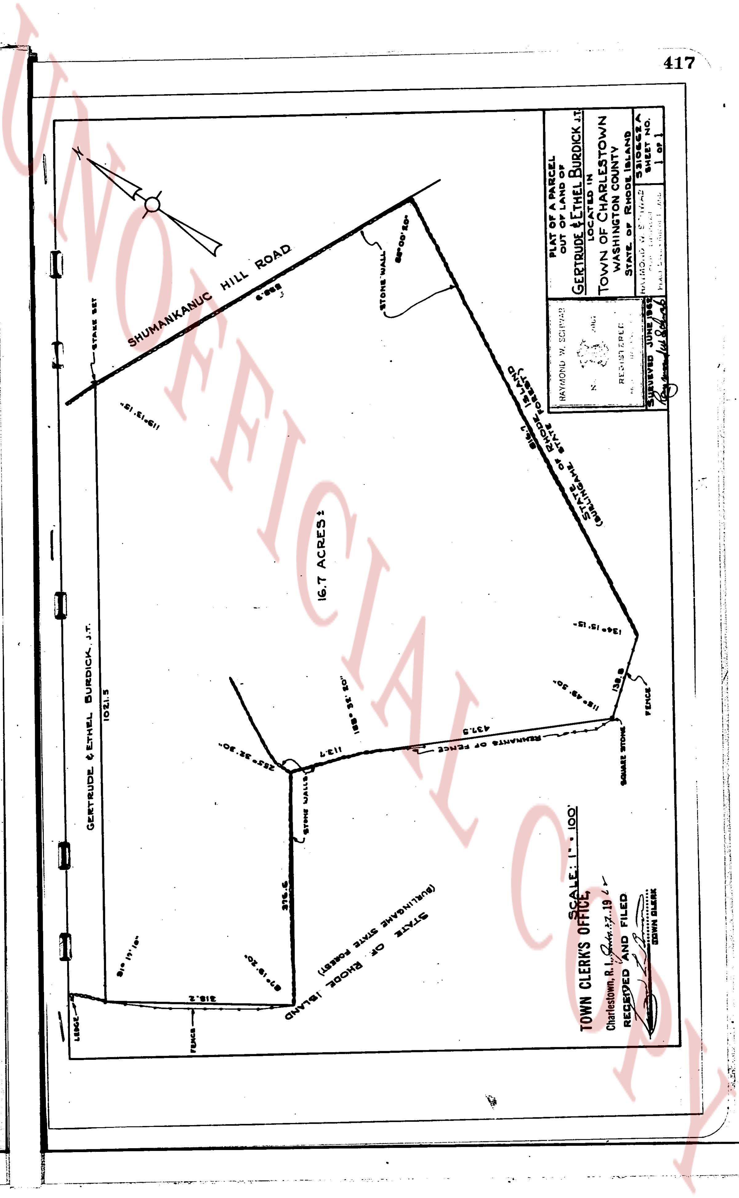
Reference is made hereby to a certain map or plat entitled "Plan of a Parcel of Land of Gertrude & Ethel Burdick Joint Tenants located in Town of Charlestown Washington County Rhode Island" signed by Ralph Burdick Civil Engineer, dated September 21, 1962 and Sheet no. 1 of 1 filed or to be filed in Records of Land Evidence of the Town of Charlestown, Rhode Island, and the same is hereby made a part of these presents.
And I, GERTRUDE BURDICK, a grantor herein, hereby covenant that I am a widow unmarried.
And I, ETHEL G. BURDICK, a grantor herein, hereby covenant that I am a single.
IN WITNESS WHEREOF, we have hereunto set our hands this 25th day of July, A. D. 1962.
GERTRUDE BURDICK
ETHEL G. BURDICK
(DOCUMENTARY STAMPS, $1.65)
STATE OF RHODE ISLAND
COUNTY OF WASHINGTON
In Charlestown, on the 25th day of July, A. D. 1962, before me personally appeared GERTRUDE BURDICK and ETHEL G. BURDICK, mother and daughter, both to me known and by me to be the parties executing the foregoing instrument, and they severally acknowledged said instrument, by them executed, to be their free act and deed.
HENRY G. HEATH (Notarial Seal)
Notary Public
Received for record July 27th, A. D. 1962 at 11:30 o'clock, a. m., and recorded by
[Signature]
Town Clerk
page 2 · read by Gemma vision
[Map image]
GERTRUDE & ETHEL BURDICK, J.T.
102.1 S
16.7 ACRES!
SHUMANKANUC HILL ROAD
STONE WALL
68' 00" 65'
PLAT OF A PARCEL
OUT OF A PARCEL
OF LAND OF
GERTRUDE & ETHEL BURDICK AT
TOWN OF CHARLESTOWN
WASHINGTON COUNTY
STATE OF RHODE ISLAND
STATE OF RHODE ISLAND
(BURLINGTON STATE FOREST)
STATE OF RHODE ISLAND
(BURLINGTON STATE FOREST)
TOWN CLERK'S OFFICE: 1" = 100'
Charlestown, R.I. July 27, 1962
RECEIVED AND FILED
[Signature]
TOWN CLERK
SURVEYOR: JING BEE
[Signature]
SHEET NO. 1
OF 1
417
The page as recorded