The instrument's own words
page 1 · read by Gemma vision
390
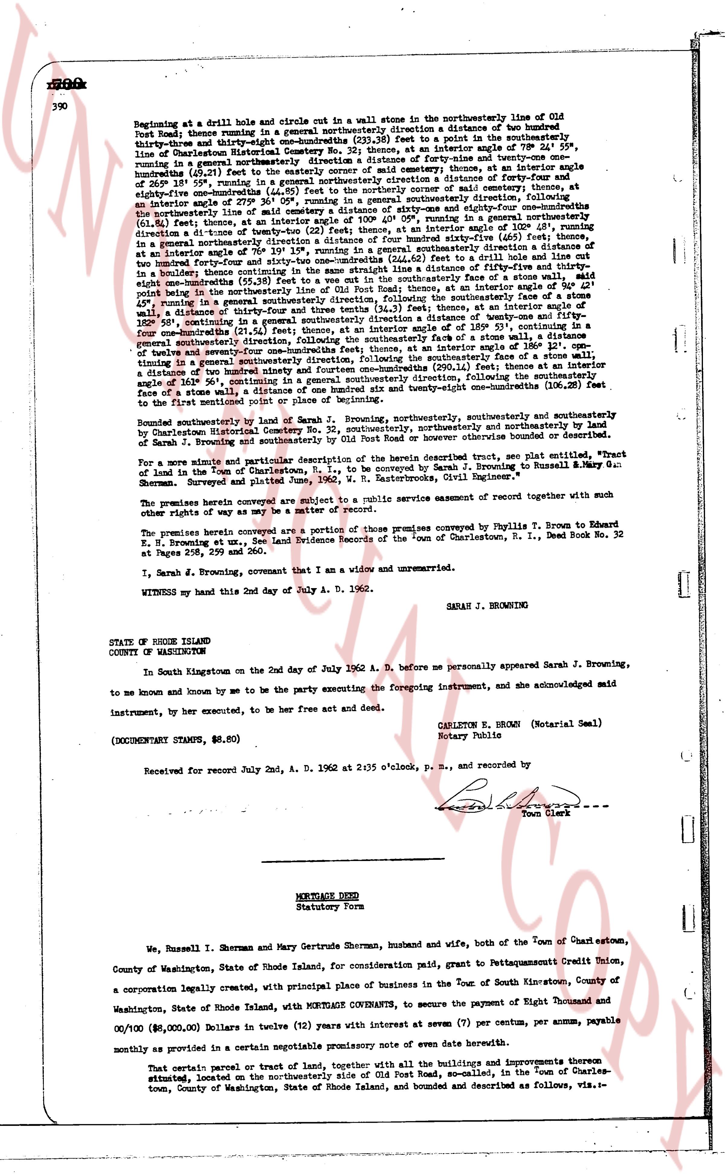
Beginning at a drill hole and circle cut in a wallstone in the northwesterly line of Old Post Road; thence running in a general northwesterly direction a distance of two hundred thirty-three and eighty-one hundredths (233.81) feet to a point in the southeasterly line of Charlestown Historical Society; thence running in a general southeasterly direction at an angle of 79° 1' 30" running in a general northeasterly direction a distance of forty-nine and twenty-one one hundredths (49.21) feet to the easterly corner of a wall; thence running at an angle of 141° 58' 30" running in a general northeasterly direction a distance of one hundred seventy-two and forty-one one hundredths (172.41) feet to a point; thence running at an angle of 81° 47' 30" running in a general northwesterly direction a distance of eighty-one and fifty-nine one hundredths (81.59) feet to the northwesterly corner of a wall; thence running at an angle of 101° 2' 30" running in a general southeasterly direction, following the northwesterly line of said cemetery a distance of sixty-one and eighty-six one hundredths (61.86) feet to an angle of 90° 0' 0"; thence running in a general northerly direction (61.86) feet thence, at an angle of 90° 0' 0" running in a general northerly direction at a distance of twenty-two (22) feet, then at an angle of 102° 26' 15" running in a general northwesterly direction a distance of one hundred forty-five and sixty-one one hundredths (145.61) feet to a point; thence running at an angle of 70° 19' 15" running in a general southeasterly direction a distance of one hundred forty-five and sixty-one one hundredths (145.61) feet to a point; thence running at an angle of 108° 40' 45" running in a general southeasterly direction a distance of fifty-five and one eighth (55 1/8) feet to a boulder; thence continuing in the same straight line a distance of fifty-five and thirty-one one hundredths (55.31) feet to a point; thence running in a general northeasterly direction a distance of four and one eighth (4 1/8) feet to a point being in the northwesterly line of Old Post Road; thence, at an angle of 94° 21' point running in a general southeasterly direction, along the southeasterly line, from this point, at an angle of 45° running in a general southeasterly direction and three tenths (34.3) feet, thence at an angle of 18° 12' 58" running in a general southeasterly direction a distance of twenty-four and one half (24 1/2) feet, continuing in a general southeasterly direction, then at an angle of 185° 53' 15" running in a general southeasterly direction, following the southeasterly line of said cemetery, then at an angle of 186° 12' 15" continuing in a general southeasterly direction, following the southeasterly line, for a distance of twenty-seven and ninety-one one hundredths (27.91) feet to a point; thence at an angle of 101° 2' 30" running in a general southeasterly direction (61.86) feet to a point; thence at an angle of 106° 50' 0" continuing in a general southeasterly direction, following the southeasterly line of a stone wall, a distance of one hundred seventy-two and forty-one one hundredths (172.41) feet to the first mentioned point or place of beginning.
Bounded southeasterly by line of Sarah J. Browning, southeasterly, southeasterly and southeasterly by Old Post Road; thence northwesterly, northwesterly and northwesterly by land of Sarah J. Browning and southeasterly by Old Post Road or however otherwise bounded or described.
For a more minute and particular description of the herein described tract, see plat entitled, "Plat of Land in the Town of Charlestown, R. I.," to be conveyed by Sarah J. Browning to Russell M. & Mary G. Sherman, surveyed and platted by George W. Sexton, Licensed Civil Engineer."
The premises herein conveyed are subject to a public service easement recorded together with such other rights of way as may be a matter of record.
The premises herein conveyed are a portion of those premises conveyed by Phyllis T. Brown to Edward K. Browning et ux, by Indenture Evidence recorded in the "book" of Charlestown, R. I., Deed Book No. 32 at Pages 259, 260 and 290.
I, Sarah J. Browning, covenant that I am a widow and unmarried.
WITNESS my hand this 2nd day of July A. D. 1962.
SARAH J. BROWNING
STATE OF RHODE ISLAND
COUNTY OF WASHINGTON
In South Kingstown on the 2nd day of July 1962 A. D. before me personally appeared Sarah J. Browning, to me known and known by me to be the party executing the foregoing instrument, and she acknowledged said instrument, by her executed, to be her free act and deed.
CARLTON E. BROWN (Notarial Seal)
Notary Public
(DOCUMENTARY STAMPS, $6.80)
Received for record July 2nd, A. D. 1962 at 2:35 o'clock, p. m., and recorded by
[Signature]
Town Clerk
----
MORTGAGE DEED
Statutory Form
We, Russell I. Sherman and Mary Gertrude Sherman, husband and wife, both of the Town of Charlestown, County of Washington, State of Rhode Island, for consideration paid, grant to Pettaquamscutt Credit Union, a corporation legally created, with principal place of business in the Town of South Kingstown, County of Washington, State of Rhode Island, with MORTGAGE COVENANTS, to secure the payment of Eight Thousand and 00/100 ($8,000.00) Dollars in twelve (12) years with interest at seven (7) per centum, per annum, payable monthly as provided in a certain negotiable promissory note of even date herewith.
That certain parcel or tract of land, together with all the buildings and improvements thereon situated, located on the northwesterly side of Old Post Road, so-called, in the Town of Charlestown, County of Washington, State of Rhode Island, and bounded and described as follows, viz.-l
page 2 · read by Gemma vision
391
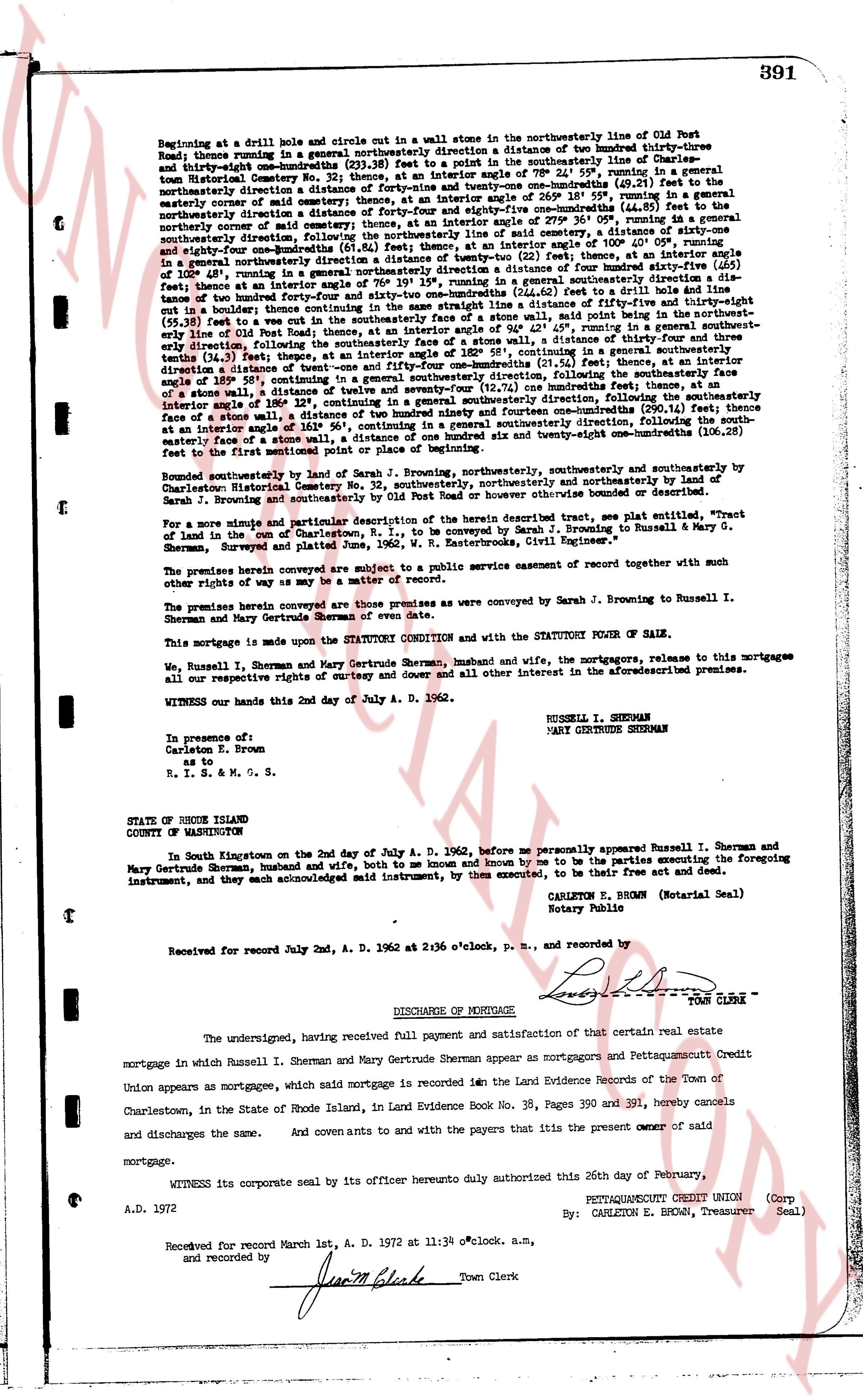
Beginning at a drill hole and circle out in a wall stone in the northeasterly line of Old Post Road; thence running in a general northeasterly direction a distance of two hundred thirty-three and thirty-eight one-hundredths (233.38) feet to a point on a stone wall; thence running in a general northeasterly direction a distance of forty-nine and twenty-one one-hundredths (49.21) feet to the easterly edge of old road; thence running in a general northeasterly direction a distance of forty-nine and twenty-one one-hundredths (49.21) feet to the northeasterly corner of said old road; thence running in a general northeasterly direction a distance of one hundred seventy-one and forty-five one-hundredths (171.45) feet; thence running in a general northeasterly direction, following the northeasterly line of said cemetery, a distance of sixty-one and eighty-four one-hundredths (61.84) feet; thence running in a general easterly direction a distance of twenty-two (22) feet, thence, at an interior angle of 108° 41', running in a general southeasterly direction a distance of one hundred four and seventy-one one-hundredths (104.71) feet; thence running in a general southeasterly direction a distance of one hundred four and seventy-one one-hundredths (104.71) feet; thence, at an interior angle of 108° 41', running in a general southeasterly direction a distance of two hundred forty-four and sixty-two one-hundredths (244.62) feet; thence running in a general southeasterly direction a distance of fifty-nine and thirty-eight one-hundredths (59.38) feet to a cut vie in the southeasterly face of a stone wall, said point being in the southeasterly line of Old Post Road; thence running in a general southwesterly direction a distance of one hundred twenty-six and seventy-one one-hundredths (126.71) feet, following the southeasterly face of a stone wall, a distance of thirty-four and three one-hundredths (34.03) feet; thence running in a general southwesterly direction, thence, at an interior angle of 159° 13', running in a general southwesterly direction a distance of twenty-one and one-hundredths (21.01) feet; thence running in a general southwesterly direction a distance of twenty-one and one-hundredths (21.01) feet; thence, at an interior angle of 159° 13', running in a general southwesterly direction a distance of twenty-one and one-hundredths (21.01) feet; thence running in a general southwesterly direction a distance of twenty-one and one-hundredths (21.01) feet; thence, at an interior angle of 159° 13', running in a general southwesterly direction a distance of twenty-one and one-hundredths (21.01) feet; thence running in a general southwesterly direction a distance of twenty-one and one-hundredths (21.01) feet; thence, at an interior angle of 159° 13', running in a general southwesterly direction a distance of twenty-one and one-hundredths (21.01) feet; thence running in a general southwesterly direction a distance of twenty-one and one-hundredths (21.01) feet; thence, at an interior angle of 159° 13', running in a general southwesterly direction a distance of twenty-one and one-hundredths (21.01) feet; thence running in a general southwesterly direction a distance of twenty-one and one-hundredths (21.01) feet; thence, at an interior angle of 159° 13', running in a general southwesterly direction a distance of twenty-one and one-hundredths (21.01) feet; thence running in a general southwesterly direction a distance of twenty-one and one-hundredths (21.01) feet; thence, at an interior angle of 159° 13', running in a general southwesterly direction a distance of twenty-one and one-hundredths (21.01) feet; thence running in a general southwesterly direction a distance of twenty-one and one-hundredths (21.01) feet; thence, at an interior angle of 159° 13', running in a general southwesterly direction a distance of twenty-one and one-hundredths (21.01) feet; thence running in a general southwesterly direction a distance of twenty-one and one-hundredths (21.01) feet; thence, at an interior angle of 159° 13', running in a general southwesterly direction a distance of twenty-one and one-hundredths (21.01) feet; thence running in a general southwesterly direction a distance of twenty-one and one-hundredths (21.01) feet; thence, at an interior angle of 159° 13', running in a general southwesterly direction a distance of twenty-one and one-hundredths (21.01) feet; thence running in a general southwesterly direction a distance of twenty-one and one-hundredths (21.01) feet; thence, at an interior angle of 159° 13', running in a general southwesterly direction a distance of twenty-one and one-hundredths (21.01) feet; thence running in a general southwesterly direction a distance of twenty-one and one-hundredths (21.01) feet; thence, at an interior angle of 159° 13', running in a general southwesterly direction a distance of twenty-one and one-hundredths (21.01) feet; thence running in a general southwesterly direction a distance of twenty-one and one-hundredths (21.01) feet; thence, at an interior angle of 159° 13', running in a general southwesterly direction a distance of twenty-one and one-hundredths (21.01) feet; thence running in a general southwesterly direction a distance of twenty-one and one-hundredths (21.01) feet; thence, at an interior angle of 159° 13', running in a general southwesterly direction a distance of twenty-one and one-hundredths (21.01) feet; thence running in a general southwesterly direction a distance of twenty-one and one-hundredths (21.01) feet; thence, at an interior angle of 159° 13', running in a general southwesterly direction a distance of twenty-one and one-hundredths (21.01) feet; thence running in a general southwesterly direction a distance of twenty-one and one-hundredths (21.01) feet; thence, at an interior angle of 159° 13', running in a general southwesterly direction a distance of twenty-one and one-hundredths (21.01) feet; thence running in a general southwesterly direction a distance of twenty-one and one-hundredths (21.01) feet; thence, at an interior angle of 159° 13', running in a general southwesterly direction a distance of twenty-one and one-hundredths (21.01) feet; thence running in a general southwesterly direction a distance of twenty-one and one-hundredths (21.01) feet; thence, at an interior angle of 159° 13', running in a general southwesterly direction a distance of twenty-one and one-hundredths (21.01) feet; thence running in a general southwesterly direction a distance of twenty-one and one-hundredths (21.01) feet; thence, at an interior angle of 159° 13', running in a general southwesterly direction a distance of twenty-one and one-hundredths (21.01) feet; thence running in a general southwesterly direction a distance of twenty-one and one-hundredths (21.01) feet; thence, at an interior angle of 159° 13', running in a general southwesterly direction a distance of twenty-one and one-hundredths (21.01) feet; thence running in a general southwesterly direction a distance of twenty-one and one-hundredths (21.01) feet; thence, at an interior angle of 159° 13', running in a general southwesterly direction a distance of twenty-one and one-hundredths (21.01) feet; thence running in a general southwesterly direction a distance of twenty-one and one-hundredths (21.01) feet; thence, at an interior angle of 159° 13', running in a general southwesterly direction a distance of twenty-one and one-hundredths (21.01) feet; thence running in a general southwesterly direction a distance of twenty-one and one-hundredths (21.01) feet; thence, at an interior angle of 159° 13', running in a general southwesterly direction a distance of twenty-one and one-hundredths (21.01) feet; thence running in a general southwesterly direction a distance of twenty-one and one-hundredths (21.01) feet; thence, at an interior angle of 159° 13', running in a general southwesterly direction a distance of twenty-one and one-hundredths (21.01) feet; thence running in a general southwesterly direction a distance of twenty-one and one-hundredths (21.01) feet; thence, at an interior angle of 159° 13', running in a general southwesterly direction a distance of twenty-one and one-hundredths (21.01) feet; thence running in a general southwesterly direction a distance of twenty-one and one-hundredths (21.01) feet; thence, at an interior angle of 159° 13', running in a general southwesterly direction a distance of twenty-one and one-hundredths (21.01) feet; thence running in a general southwesterly direction a distance of twenty-one and one-hundredths (21.01) feet; thence, at an interior angle of 159° 13', running in a general southwesterly direction a distance of twenty-one and one-hundredths (21.01) feet; thence running in a general southwesterly direction a distance of twenty-one and one-hundredths (21.01) feet; thence, at an interior angle of 159° 13', running in a general southwesterly direction a distance of twenty-one and one-hundredths (21.01) feet; thence running in a general southwesterly direction a distance of twenty-one and one-hundredths (21.01) feet; thence, at an interior angle of 159° 13', running in a general southwesterly direction a distance of twenty-one and one-hundredths (21.01) feet; thence running in a general southwesterly direction a distance of twenty-one and one-hundredths (21.01) feet; thence, at an interior angle of 159° 13', running in a general southwesterly direction a distance of twenty-one and one-hundredths (21.01) feet; thence running in a general southwesterly direction a distance of twenty-one and one-hundredths (21.01) feet; thence, at an interior angle of 159° 13', running in a general southwesterly direction a distance of twenty-one and one-hundredths (21.01) feet; thence running in a general southwesterly direction a distance of twenty-one and one-hundredths (21.01) feet; thence, at an interior angle of 159° 13', running in a general southwesterly direction a distance of twenty-one and one-hundredths (21.01) feet; thence running in a general southwesterly direction a distance of twenty-one and one-hundredths (21.01) feet; thence, at an interior angle of 159° 13', running in a general southwesterly direction a distance of twenty-one and one-hundredths (21.01) feet; thence running in a general southwesterly direction a distance of twenty-one and one-hundredths (21.01) feet; thence, at an interior angle of 159° 13', running in a general southwesterly direction a distance of twenty-one and one-hundredths (21.01) feet; thence running in a general southwesterly direction a distance of twenty-one
The page as recorded