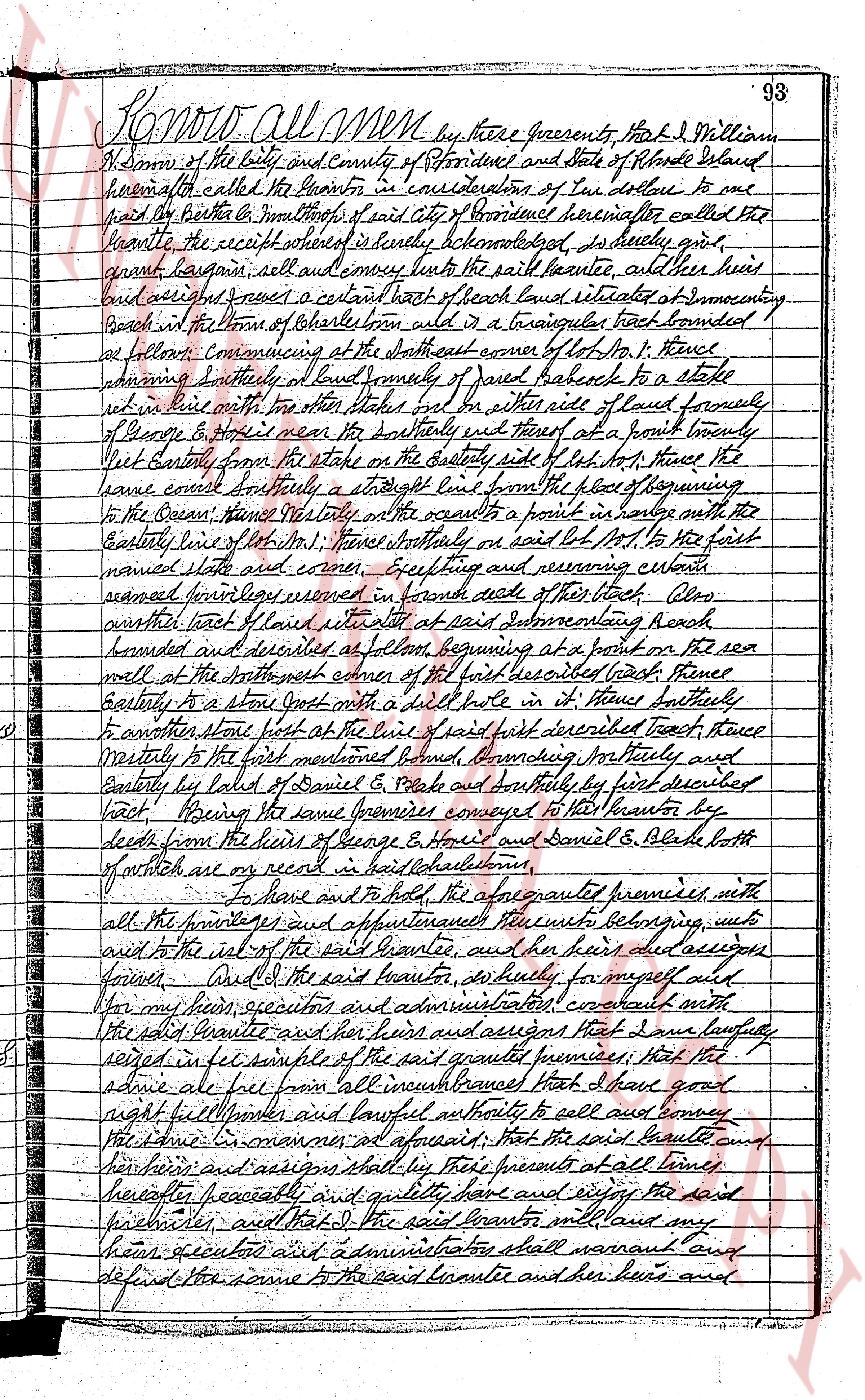
The instrument's own words
Attribution under review. The portal's file number is shared by more than one instrument, and the words below could not be placed with certainty on this one by their own evidence (page stamp, parties, dates); they may belong to a neighbouring instrument. Read them as the record of the page, not yet as this deed's own.
page 1
Know all Men by these presents That I William
W. Simmons of the city and County of Providence and State of Rhode Island
hereinafter called the Grantor in consideration of ten dollars to me
paid by the Brother & Mothers Inc of city of Providence hereinafter called the
Grantee the receipt whereof is hereby acknowledged as duly paid,
grant, bargain sell and convey unto the said Grantee, and their heirs
and assigns forever a certain lot of beach land situated at intersecting
Beach in the town of Charlestown rhd in a triangular tract bounded
as follows: commencing at the southeasterly corner of lot No. 1, thence
running easterly to said boundary of said beach to a stake
set in the line with other stakes set on the side roads of said family
of George B & more or less on the southeasterly and thence at a point twenty
feet easterly from the stake on the Easterly side of lot No. 1 thence the
same line easterly a straight line from the place of beginning
to the Ocean, thence westerly on the ocean to a point in line with the
Easterly line of lot No. 1, thence northerly or west lot No. 1 to the first
named stake and corner. Excepting and reserving certain
easements however reserved in favor deeds of the tract. Also
another tract of beach land situated at said Intersecting Beach
bounded and described as follows beginning at a point on the sea
wall at the southeasterly corner of the first described tract thence
easterly to a stone wall with a drill hole in it thence southerly
to another stone wall at the line of first described tract thence
westerly to the first mentioned bound, bounding northerly and
easterly by land of Daniel G. Black and southerly by first described
tract. Being the same premises conveyed to the Grantor by
deeds from the heirs of George B. Horris and Daniel G. Black both
of which are on record in said Charlestown.
To have and to hold the aforesaid premises with
all the privileges and appurtenances thereunto belonging unto
and to the use of the said Grantee, and their heirs and successors
forever. And I the said Grantor, do hereby for myself and
for my heirs executors and administrators covenant with
the said Grantee and their heirs and assigns that I have lawfully
seized in fee the said granted premises; that the
same are free from all encumbrances that I have good
right full power and lawful authority to sell and convey
the same. In witness whereof, at officials, that the said Grantee and
their heirs and assigns shall by these presents at all times
hereafter peacefully and quietly have and enjoy the said
premises, and that I the said Grantor and my
heirs executors and administrators shall warrant and
defend the same to the said Grantee and their heirs and
page 2
391
Beginning at a drill hole and circle out in a westly stone wall in the northerlyline of Old Post
Road; thence running in a general northeasterly direction a distance of two hundred thirty-three
and thirty-eight one-hundredths (233.38) feet to a point on a stone wall; thence running in a general
northeasterly direction at an interior angle of 78° 24' 55", running in a general
northeasterly direction a distance of forty-nine and twenty-one one-hundredths (49.21) feet to the
easterly edge of old road; thence running in a general northeasterly direction a distance of forty-
northeasterly direction a distance of forty-four and eighty-five one-hundredths (44.85) feet to the
northerly corner of said old road; thence running in a general northeasterly direction a distance of
sixty-seven one-hundredths, following the northeasterly line of said cemetery, a distance of sixty-one
and eighty-four one-hundredths (61.84) feet; thence, at an interior angle of 108° 11' 30", running in a
general northeasterly direction a distance of twenty-two (22) feet; thence, at an interior angle
of 102° 48', running in a general northeasterly direction a distance of four hundred eighty-three
feet; thence at an interior angle of 111° 11' 30", running in a general southeasterly direction a dis-
tance of two hundred forty-four and sixty-two one-hundredths (244.62) feet; thence at an interior
angle of 108° 48' 30", running in a general southeasterly direction a distance of fifty-five and thirty-eight
one-hundredths (55.38) feet to a cut vie in the southeasterly half of a stone wall, said point being in the
east boundary line of said cemetery; thence running in a general southwesterly direction a distance
of 115.50 feet, running in a general southwesterly direction a distance of one hundred fifteen and fifty
southeasterly direction, following the southwesterly face of a stone wall, a distance of forty-three and three
fourths (43.75) feet; thence running in a general southwesterly direction a distance of one hundred
distance of a distance of twenty-one and forty-five one-hundredths (21.45) feet; thence, at an interior
angle of 159° 11' 30", running in a general southwesterly direction a distance of one hundred twenty-
one and six one-hundredths (121.06) feet; thence, at an interior angle of 120° 11' 30", running in a
distance of a stone wall and distance of twelve and seventy-two one-hundredths (12.72) one hundredths feet, at an
interior angle of 182° 12', continuing in a general southwesterly direction a distance of one hundred
fifty-four feet; thence at an interior angle of two hundred forty-nine and fourteen one-hundredths (249.14) feet; thence
at an interior angle of 181° 50', continuing in a general southwesterly direction a distance of one hundred
sixty-six and twenty-eight one-hundredths (166.28) feet,
bound to the first mentioned point or place of beginning as heretofore described.
Bounded southerly by land of Sarah J. Browning, northeasterly and southeasterly by the
Charlestown State Hospital grounds, northwesterly, northeasterly and northeasterly by land of
Sarah J. Browning and southeasterly by Old Post Road or however otherwise bounded or described.
f For a more precise and particular description of the herein described tract, see plat entitled, "Tract
of land in the Town of Charlestown, State of Rhode Island, from Russell J. Browning to Russell M. G.
Sherman, Surveyed and Platted June, 1962, W. R. Easterbrook Civil Engineer," G.V.
The premises herein conveyed are subject to a public service easement of record together with other
rights of ways that may be a matter of record.
The premises herein conveyed are those premises as were conveyed by Sarah J. Browning to Russell I.
Sherman and Mary Gertrude Sherman.
This mortgage is made upon the STATUTORY Condition and with the STATUTORY Power of Sale.
We, Russell I. Sherman and Mary Gertrude Sherman, husband and wife, the mortgagors, release to this mortgagee
all our respective rights of curtesy and dower and all other interest in the aforementioned premises.
WITNESS our hands this 2nd day of July A. D. 1962.
RUSSELL I. SHERMAN
MARY GERTRUDE SHERMAN
In presence of:
Carleton E. Brown
as to
R. I. S. & M. G. S.
STATE OF RHODE ISLAND
COUNTY OF WASHINGTON
In South Kingstown on the 2nd day of July A. D. 1962, before me personally appeared Russell I. Sherman and
Mary Gertrude Sherman, husband and wife, both to be known and known by me to be the parties executing the foregoing
instrument, and they each acknowledged said instrument, by them executed, to be their free act and deed.
CARLETON E. BROWN (Notarial Seal)
Notary Public
Received for record July 2nd, A. D. 1962 at 2:36 o'clock, p. m., and recorded by
[Signature] TOWN CLERK
DISCHARGE OF MORTGAGE
The undersigned, having received full payment and satisfaction of that certain real estate
mortgage in which Russell I. Sherman and Mary Gertrude Sherman appear as mortgagors and Pettaquogue Credit
Union appears as mortgagees, which said mortgage is recorded in the Land Evidence Records of the Town of
Charlestown, in the State of Rhode Island, in Land Evidence Book No. 38, Pages 390 and 391, hereby cancels
and discharges the same. And covenants to and with the payers that it titles the present owner of said
mortgage.
WITNESS its corporate seal by its officer hereunto duly authorized this 26th day of February,
A.D. 1972
PETTAQUOGUE CREDIT UNION (Corp
By: CARLETON E. BROWN, Treasurer (Seal)
Received for record March 1st, A. D. 1972 at 11:34 o'clock, a.m,
and recorded by [Signature] Town Clerk
The page as recorded