The instrument's own words
page 1 · read by Gemma vision
689
389
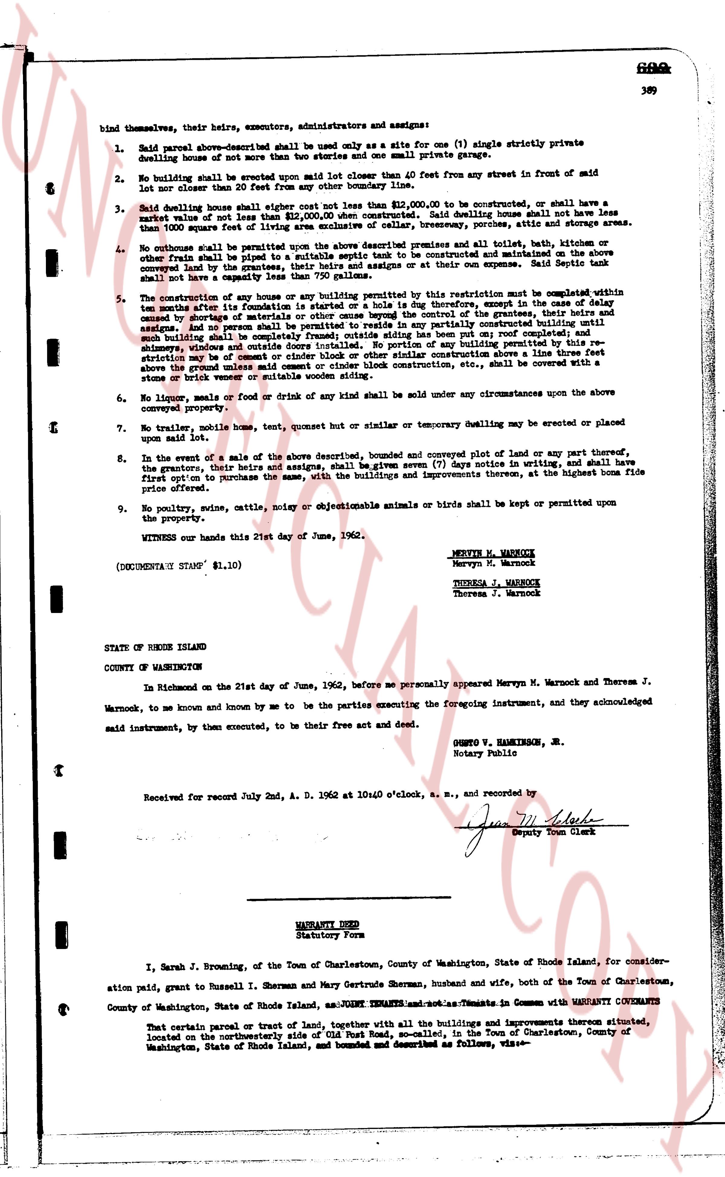
bind themselves, their heirs, executors, administrators and assigns:
1. Said parcel above-described shall be used only as a site for one (1) single strictly private dwelling house of not more than two stories and one small private garage.
2. No building shall be erected upon said lot closer than 40 feet from any street in front of said lot nor closer than 20 feet from any street other than the front street.
3. Said dwelling house shall either cost not less than $12,000.00 to be constructed, or shall have a market value of not less than $12,000.00 when constructed. Said dwelling house shall not have less than 1000 square feet of living area exclusive of cellar, breezeway, porches sitting room or sun areas.
4. No outhouse shall be permitted upon the above described premises and all toilet and bath, other than outdoor free plumbing to be installed in the dwelling house, or septic tank to be constructed and maintained on the above conveyed land by the grantees, their heirs and assigns at or their own expense. Said septic tank shall not be located in a ravine or stream bed.
5. The construction of any house or any building permitted by this restriction must be completed within ten months after its foundation is started or a pole is dug halfway, except in the case of delay caused by shortage of materials or labor, or by the illness or death of the grantee, his heirs and assigns. And no person shall be permitted to reside in or partially any constructed building until building shall be complete with roof, sides, front and rear, and all necessary chimneys, windows and outside doors installed. No portion of any building permitted by this restriction may be of a board and batten construction. Any structure or construction located above the ground using unfaced nail cement or stone block construction etc., shall be covered with a stone or brick veneer or suitable wooden siding section.
6. No liquor, meals or food or drink of any kind shall be sold under any circumstances upon the above conveyed property.
7. No trailer, mobile home, tent, quonset or similar or temporary dwelling may be erected or placed upon said lot.
8. In the event of a sale of the above described, bounded and conveyed plot of land or any part thereof, the grantors, their heirs and assigns, shall be given seven (7) days notice in writing, and shall have first option to purchase the same, with the buildings and improvements thereon, at the highest bona fide price offered.
9. No poultry, swine, cattle, noisy or objectionable animals or birds shall be kept or permitted upon the property.
WITNESS our hands this 21st day of June, 1962.
MERVIN W. WARNOCK
Mervyn W. Warnock
THERESA J. WARNOCK
Theresa J. Warnock
(DOCUMENTARY STAMP $1.10)
STATE OF RHODE ISLAND
COUNTY OF WASHINGTON
In Richmond on the 21st day of June, 1962, before me personally appeared Mervyn W. Warnock and Theresa J. Warnock, to me known and known by me to be the parties executing the foregoing instrument, and they acknowledged said instrument, by them executed, to be their free act and deed.
QUENTO V. HAMILTON, JR.
Notary Public
Received for record July 2nd, A. D. 1962 at 10:40 o'clock, a. m., and recorded by
[Signature]
Deputy Town Clerk
----
WARRANTY DEED
Statutory Form
I, Sarah J. Browning, of the Town of Charlestown, County of Washington, State of Rhode Island, for consideration paid, grant to Russell I. Sherman and Mary Gertrude Sherman, husband and wife, both of the Town of Charlestown, County of Washington, State of Rhode Island, as jointly tenants and as tenants in common with WARRANTY COVENANTS
That certain parcel or tract of land, together with all the buildings and improvements thereon situated, located on the northwesterly side of Old Post Road, so called, in the Town of Charlestown, County of Washington, State of Rhode Island, and bounded and described as follows, viz:-
page 2 · read by Gemma vision
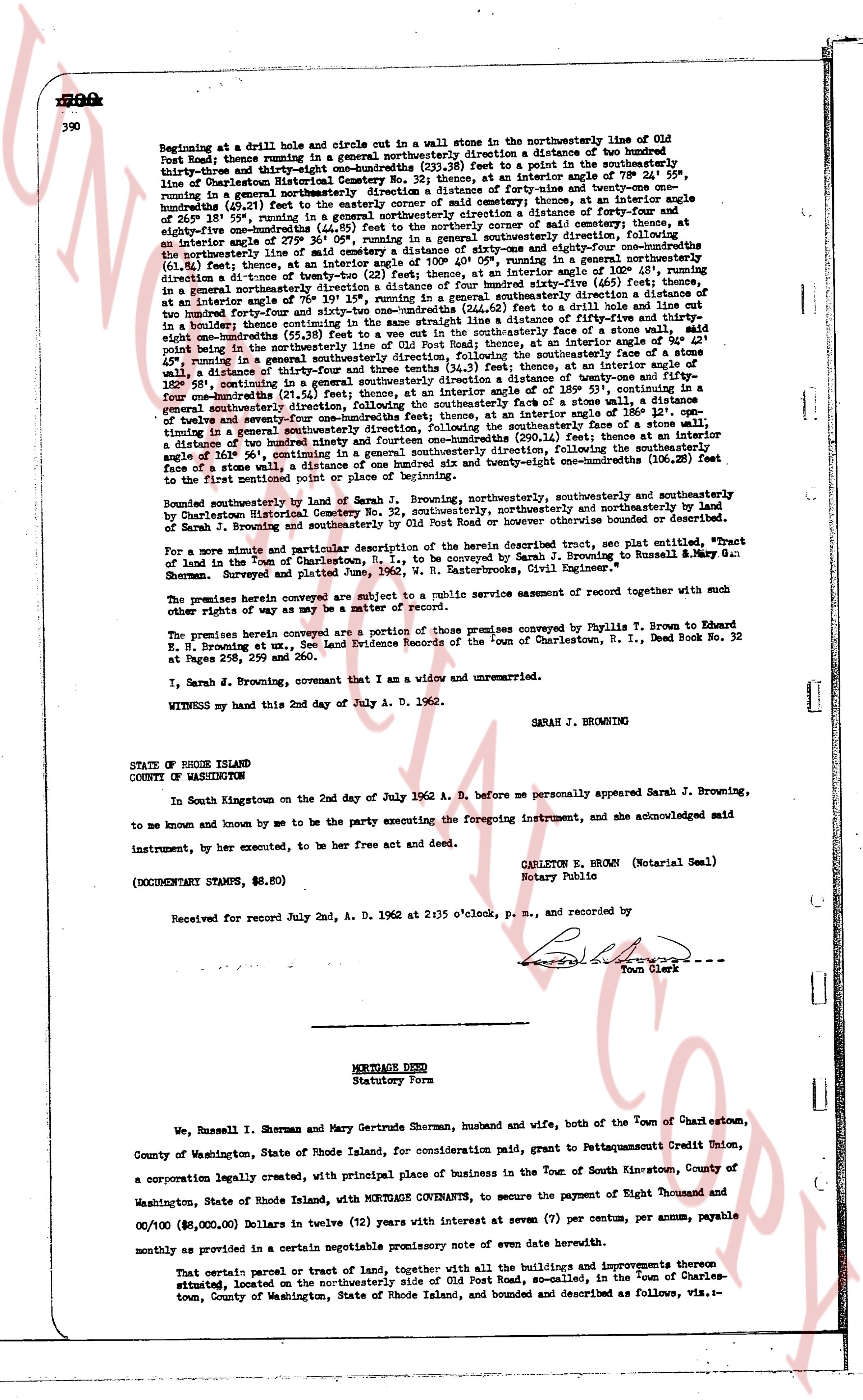
Beginning at a drill hole and circle out in a wallstone in the northwesterly line of Old
Post Road; thence running in a general northwesterly direction a distance of two hundred
thirty-three and eighty-one hundredths (233.81) feet to a point in the southeasterly line
of Charlestown Historical Society; thence running at an interior angle of 79° 1' 30" east,
running in a general northeasterly direction a distance of forty-nine and twenty-one one
hundredths (49.21) feet to the easterly corner of a stone wall; thence at an interior angle of 145°
running in a general northeasterly direction a distance of one hundred forty-six and twenty-one
eighty-one hundredths (146.81) feet to the northwesterly corner of said wall; thence running southwesterly,
following the northwesterly line of said cemetery a distance of sixty-one and eighty-six one
hundredths (61.86) feet to an interior angle of 105° 1' 30"; thence running in a general northeasterly
direction at an interior angle of 22° (feet), at an interior angle of 105° 21', running in an
interior angle of 105° 21' running in a general northeasterly direction a distance of
one hundred forty-six and twenty-one hundredths (146.21) feet to a point in a wall; thence,
at an interior angle of 70° 19' 15", running in a general southeasterly direction a distance of
one hundred forty-six and twenty-one hundredths (146.21) feet to a point in a wall and
in a boulder; thence continuing in the same straight line a distance of fifty-five and thirty-
one hundredths (55.31) feet to the northwesterly direction line of Old Post Road; thence at an interior angle of 94° 21'
point being in the northwesterly direction line of Old Post Road; thence, as the southeasterly line, 45° 21'
running in a general southeasterly direction and three tenths (34.3) feet, thence at an interior angle of 85°
wall a distance of thirty-three and one hundredths (33.01) feet, continuing in a
general southeasterly direction, following the northwesterly line of Old Post Road; thence at an interior angle of 185° 53', continuing in a
general southeasterly direction, following the northwesterly line of Old Post Road; thence at an interior angle of 186° 12', con-
tinuing in a general southeasterly direction, following the northwesterly line, a distance of four and a
tenth (4.1) feet to a point in a wall; thence running in a general southwesterly direction (50.3) feet to an interior
angle of 104° 50', continuing in a general southeasterly direction, following the northwesterly line
of a stone wall, a distance of one hundred forty-six and twenty-one hundredths (146.21) feet
to the first mentioned point or place of beginning.
Bounded northerly by land of Sarah J. Browning, northwesterly southeasterly and southeasterly
by Charlestown Historical Society and northwesterly and southeasterly by land
of Sarah J. Browning and southeasterly by Old Post Road or however otherwise bounded or described.
For a more minute and particular description of the herein described tract, see plat entitled, "Plat
of land in the Town of Charlestown, R. I., to be conveyed by Sarah J. Browning to Russell H. Sherman & Mary
Gertrude Sherman" prepared and signed by "R. Russell H. Sherman, Civil Engineer".
The premises herein conveyed are subject to a public service easement recorded together with such
other rights of way as may be a matter of record.
The premises herein conveyed are a portion of those premises conveyed by Phyllis T. Brown to Edward
K. Browning et ux, by Indenture Evidence recorded in the "town" of Charlestown, R. I., Deed Book No. 32,
at Pages 299, 298 and 290.
I, Sarah J. Browning, covenant that I am a widow and unmarried.
WITNESS my hand this 2nd day of July A. D. 1962.
SARAH J. BROWNING
STATE OF RHODE ISLAND
COUNTY OF WASHINGTON
In South Kingstown on the 2nd day of July 1962 A. D. before me personally appeared Sarah J. Browning,
to me known and known by me to be the party executing the foregoing instrument, and she acknowledged said
instrument, by her executed, to be her free act and deed.
CARLTON E. BROWN (Notarial Seal)
Notary Public
(DOCUMENTARY STAMPS, $6.80)
Received for record July 2nd, A. D. 1962 at 2:35 o'clock, p. m., and recorded by
[Signature]
Town Clerk
----
MORTGAGE DEED
Statutory Form
We, Russell I. Sherman and Mary Gertrude Sherman, husband and wife, both of the Town of Charlestown,
County of Washington, State of Rhode Island, for consideration paid, grant to PawtucketSavings Credit Union,
a corporation legally created, with principal place of business in the Town of South Kingstown, County of
Washington, State of Rhode Island, with MORTGAGE COVENANTS, to secure the payment of Eight Thousand and
00/100 ($8,000.00) Dollars in twelve (12) years with interest at seven (7) per centum, per annum, payable
monthly as provided in a certain negotiable promissory note of even date herewith.
That certain parcel or tract of land, together with all the buildings and improvements thereon
situated, located on the northwesterly side of Old Post Road, so-called, in the Town of Charles-
ton, County of Washington, State of Rhode Island, and bounded and described as follows, viz.-
The page as recorded