The instrument's own words
page 1 · read by Gemma vision
381
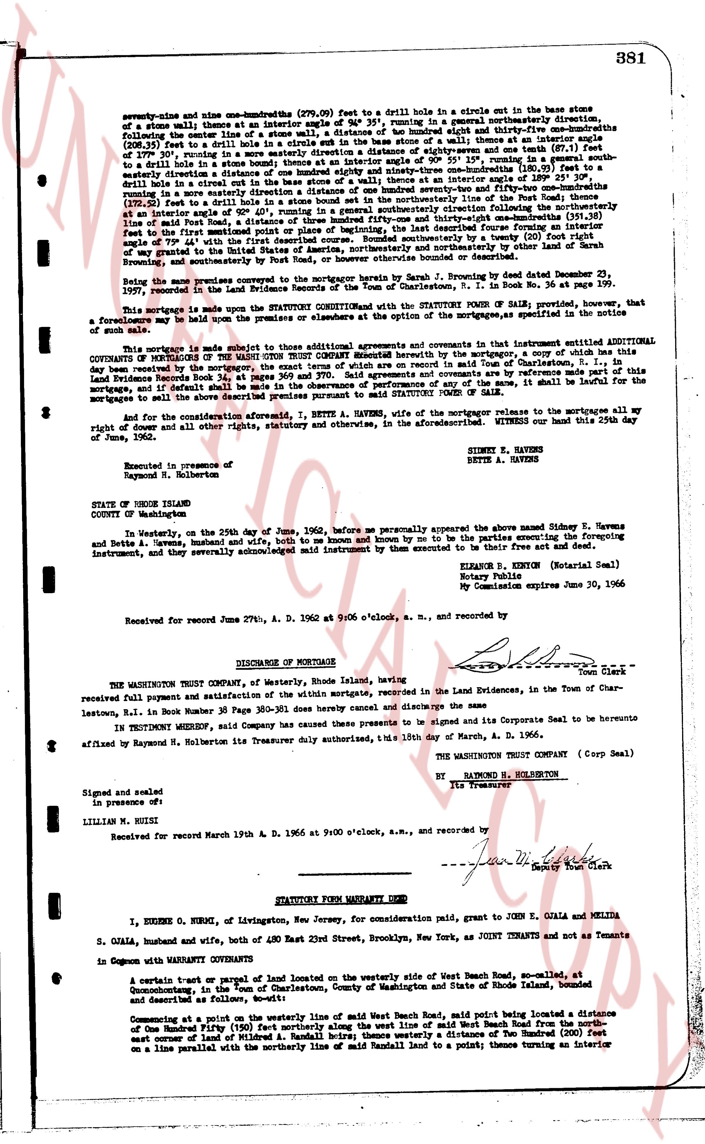
seventy-nine and nine one-hundredths (79.09) feet to a drill hole in a circle out in the base stone
of a stone wall; thence at an interior angle of 94° 35', running in a generally northeasterly direction,
following the center line of a stone wall, a distance of one hundred eighty-eight and seven-tenths (188.7)
(208.7 feet to a drill hole in a circle out in the base stone of a stone wall; thence at an interior angle
of 177° 30', running in a more easterly direction a distance of eighteen and seven tenths (18.7) feet
to a drill hole in a stone wall; thence at an interior angle of 151° 10', running in a generally south
easterly direction a distance of one hundred eighty-three and ninety-three one-hundredths (183.93) feet to a
drill hole in a stone wall; thence at an interior angle of 151° 10', running in a generally south
easterly direction a distance of one hundred twenty-three and fifty-two one-hundredths (123.52) feet
(122.52 feet) to a drill hole in a stone wall; thence at an interior angle of 151° 10', running in a generally
south easterly direction a distance of eighty feet, of beginning, the last described survey forming an interior
angle of 79° 44' with the first described course. Bounded southerly by the south line of the above described
of my tract in the town of Charlestown, Rhode Island, and bounded northerly by other land of Sarah
Browning, and southeasterly by road of Potter Road, or however otherwise bounded or described.
Being the same premises conveyed to the mortgagor by Sarah J. Browning by deed dated December 23,
1959, recorded in the land evidence book 35, page 171, and by deed in Book No. 36 at page 199.
This mortgage is made upon the STATUTORY CONDITION and with the STATUTORY POWER OF SALE; provided, that
a foreclosure may be had upon the premises or elevators at the option of the mortgagee, as specified in the notice
of such sale.
This mortgage is made subject to those additional agreements and covenants which in a contaminant instrument added
ADDITIONAL COVENANTS OF THE WASHINGTON TRUST COMPANY Grantee hereof by the mortgagor, a copy of which has
been delivered to the mortgagor, and dated the eighteenth day of June, 1962. Said agreements and covenants are by reference
made part of this
land Record evidence book 38, page 381, and dated 6/27/1962. And if default shall be made in the observance of performances of any of the same, it shall be lawful for the
mortgagee to call the whole of the above described sum, principal and interest, due.
And for the consideration aforesaid, I, BETTE A. HAVENS, wife of the mortgagor release to the mortgagee all my
right of dower and all other rights, statutory and otherwise, in the aforesaid premises. Witness our hand this 29th day
of June, 1962.
SIDNEY E. HAVENS
BETTE A. HAVENS
Executed in presence of
RAYMOND N. HOLBERTON
STATE OF RHODE ISLAND
COUNTY OF WASHINGTON
In Westerly, on the 29th day of June, 1962, before me personally appeared the above named Sidney E. Havens
and Bette A. Havens, husband and wife, both known to me and known by me to be the parties executing the foregoing
instrument, and they severally acknowledged said instrument by them executed to be their free act and deed.
ELEANOR B. EXTION (Notarial Seal)
Notary Public
My Commission expires June 30, 1966
Received for record June 29th, A. D. 1962 at 9:06 o'clock, a. m., and recorded by [?]
----
DISCHARGE OF MORTGAGE
THE WASHINGTON TRUST COMPANY, of Westerly, Rhode Island, having
[?] town Clerk
received full payment and satisfaction of the within mortgage, recorded in the Land Evidences, in the Town of Char-
leastown, R.I. in Book Number 35 Page 380-381 does hereby cancel and discharge the same
IN TESTIMONY WHEREOF, said Company has caused these presents to be signed and its Corporate Seal to be hereunto
affixed by Raymond N. Holberton its Treasurer duly authorized, this 15th day of March, A. D. 1966.
THE WASHINGTON TRUST COMPANY (Corp Seal)
BY RAYMOND N. HOLBERTON
Its Treasurer
Signed and sealed
in presence of:
LILLIAN M. RUISI
Received for record March 19th A. D. 1966 at 9:00 o'clock, a.m., and recorded by [?] Deputy Town Clerk
----
STATUTORY FORM WARRANTY DEED
I, EUGENE O. NURMI, of Livingston, New Jersey, for consideration paid, grant to JOHN E. OJALA and MELIDA
S. OJALA, husband and wife, both of 480 East 23rd Street, Brooklyn, New York, as JOINT TENANTS and not as Tenants
in Common with WARRANTY COVENANTS
A certain tract or parcel of land located on the westerly side of West Beach Road, so-called, at
Quonochonticut, in the town of Charlestown, County of Washington, State of Rhode Island, bounded
and described as follows, namely:
Commencing at a point on the westerly line of said west Beach Road, said point being located a distance
of One Hundred Fifty (150) feet northerly along the west line of said West Beach Road from the north
east corner of land of Mildred A. Randall heirs; thence easterly a distance of one hundred (100) feet
on a line parallel with the northerly line of said Randall land to a point; thence turning an interior
page 2 · read by Gemma vision
382
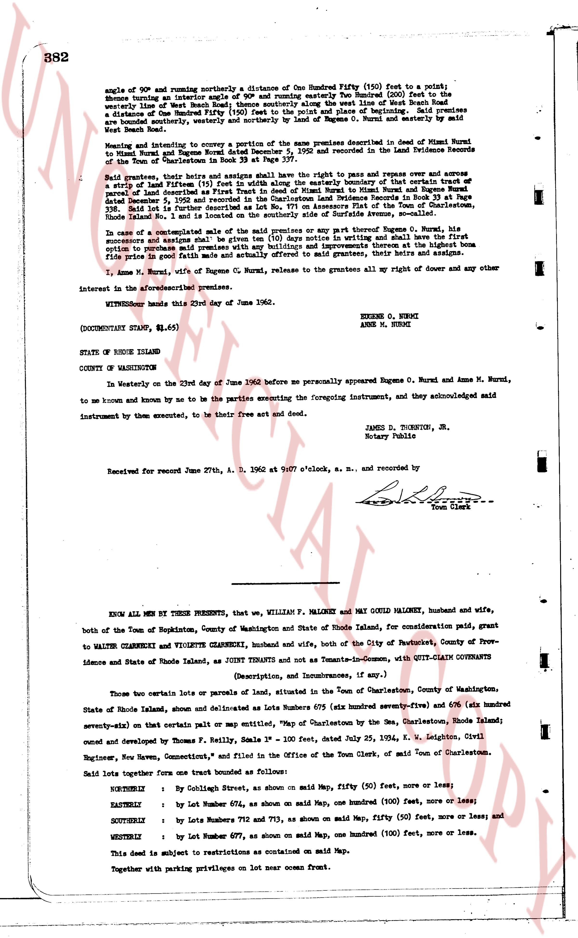
angle of 90° and running northerly a distance One Hundred Fifty (150) feet to a point;
thence turning an interior angle of 90° and running easterly Two Hundred (200) feet to the
easterly line of West Beach Road thence southerly along the west line of West Beach Road
a distance One Hundred Fifty (150) feet to the point and place of beginning. Said premises
are bounded southerly, westerly and northerly by land of Eugene O. Nurmi and easterly by
West Beach Road.
Meaning and intent to convey a suction of the same premises described in deed of Mimi Nurmi
to Nurmi Anne M and Nurmi Eugene O dated December 5, 1952 and recorded in the Land Evidence
Records of the Town of Charlestown in Book 33 at Page 239.
Said grantees, their heirs and assigns shall have the right to pass and repress over and across
a strip of land Fifteen (15) feet wide along the easterly boundary of that certain tract of
parcel of land situated in West Beach Road described in deed to Nurmi Anne M and Eugene Nurmi
dated December 5, 1952 and recorded in the Charlestown Land Evidence Records in Book 33 at Page
239. Said lot is further described as Lot 1 in the subdivision plan of the View of the Oceansides,
Rhode Island No 1 and is located on the southerly side of Surfside Avenue, so-called.
In case of a contemplated sale of the above premises or any part thereof Sobregrane O. Nurmi, his
successors and assigns shall have the first option to purchase said premises by giving written and shall have first
option to purchase said premises with any buildings and improvements thereon at the highest bona
fide price in good faith made and actually offered to said grantees, their heirs and assigns.
I, Anne M. Nurmi, wife of Eugene O. Nurmi, release to the grantees all my right of dower and any other
interest in the aforesaid premises.
WITNESS our hands this 23rd day of June 1962.
EUGENE O. NURMI
ANNE M. NURMI
(DOCUMENTARY STAMP, $1.65)
STATE OF RHODE ISLAND
COUNTY OF WASHINGTON
In Westerly on the 23rd day of June 1962 before me personally appeared Eugene O. Nurmi and Anne M. Nurmi,
to me known and known by me to be the parties executing the foregoing instrument, and they acknowledged
said instrument by them executed, to be their free act and deed.
JAMES D. THORNTON, JR.
Notary Public
Received for record June 27th, A. D. 1962 at 9:07 o'clock, a. m., and recorded by
[Signature]
Town Clerk
----
KNOW ALL MEN BY THESE PRESENTS, that we, WILLIAM P. MALONEY and MAY COLD MALONEY, husband and wife,
both of the Town of Hopkinton, County of Washington and State of Rhode Island, for consideration paid, grant
to WALTER CHIARNEKI and VIOLETTE CHIARNEKI, husband and wife, both of the City of Pawtucket, County of Prov-
idence and State of Rhode Island, as JOINT TENANTS and not as Tenants-in-Common, with QUIT-CLAIM COVENANTS
(Description, and Incumbrances, if any.)
Those two certain lots or parcels of land, situated in the Town of Charlestown, County of Washington,
State of Rhode Island, shown and delineated as Lots Numbers 679 (six hundred seventy-five) and 676 (six hundred
seventy-six) than certain plat or map entitled "Map of Charlestown by the Sea, Charlestown, Rhode Island;
owned and compiled by Thomas P. Reilly, Scale 1" = 100' feet, dated July 25, 1924, K. W. Leighton, Civil
Engineer, New Haven, Connecticut," and filed in the Office of the Town Clerk, of said Town of Charlestown.
Said lots together form one tract bounded as follows:
NORTHERLY : by Colleigh Street, as shown on said Map, fifty (50) feet, more or less;
EASTERLY : by Lot Number 674, as shown on said Map, one hundred (100) feet, more or less;
SOUTHERLY : by Lots Numbers 712 and 713, as shown on said Map, fifty (50) feet, more or less; and
WESTERLY : by Lot Number 677, as shown on said Map, one hundred (100) feet, more or less.
This deed is subject to restrictions as contained on said Map.
Together with parking privileges on lot near ocean front.
The page as recorded