The Deed Walker · From Ninigret · Charlestown, Rhode Island land evidence, 1738 to today
Trail: 7433 › 7914 › 7433

4/21/1925 · MORTGAGE DISCHARGE · book 19 page 522 doc 7433

From RICHARD ALFRED J
To KENYON LOANZE HORTENSE
Premises tract of land at shore of Cedarstorm Pond (Cedarstorm Pond, Hill Pasture, Charlestown)
Also on this page: DEED WINN SAMUEL

Back — where this land came from

This instrument states no source of title that we have read yet.

The grantor's earlier acquisitions, by name — the man, not necessarily this land

◀ 1925 · DEED · ARNOLD THOMAS L; ARNOLD MARY N → RICHARD ALFRED J · book 22 p 82
◀ 1925 · MORTGAGE · CHURCH CLARENCE A → RICHARD ALFRED J · book 22 p 95
◀ 1925 · DEED · KENYON LOANZA HORTENSE → RICHARD ALFRED J · book 21 p 454
◀ 1925 · DEED · HOLT BESSIE C → RICHARD ALFRED J · book 21 p 500
◀ 1925 · DEED · GREENE CHAS J ADMINISTRATOR; KENYON DAVID C ESTATE OF → RICHARD ALFRED J · book 21 p 501
◀ 1921 · MORTGAGE · KENYON LOANZA HORTENSE → RICHARD ALFRED J · book 19 p 519
◀ 1919 · DEED · GREEN ANNIE R → RICHARD ALFRED J · book 19 p 190
◀ 1919 · LEASE · COLUMBIA NARROW FABRIC CO; RICHARD ALFRED J → RICHARD ALFRED J; COLUMBIA NARROW FABRIC CO · book 19 p 207
◀ 1918 · DEED · DUCKWORTH CARRIE E; DUCKWORTH MILTON → RICHARD ALFRED J · book 19 p 45
◀ 1918 · MORTGAGE · CLARK CHARLES C; CLARK HARRIET L → RICHARD ALFRED J · book 19 p 54
◀ 1916 · DEED · CLARKE THOMAS G; CLARKE JOANNA R → RICHARD ALFRED J · book 18 p 336
◀ 1915 · DEED · CLARKE THOMAS G; CLARKE JOANNA R → RICHARD ALFRED J · book 18 p 202
◀ 1914 · DEED · PEARSON MARY A → RICHARD ALFRED J · book 18 p 90
◀ 1913 · DEED · GAVITT OLIVER; MORGAN SUSAN F; KING THANKFUL A; GAVITT MARGARET M; GAV → RICHARD ALFRED J · book 17 p 389

Forward — where this land went

⛔ The record we hold stops here: no later instrument we have read cites this one, and no later conveyance by the grantee is linked by name. The index is complete to 1987, so the gap is in the words: deeds of this era seldom cite book and page, and only about half the instruments of 1936-1965 have been transcribed (some 6,000 were never imaged), so a citation to this deed may sit in a page not yet read.

The instrument's own words

page 1
522 execute such deed or deeds confirmatory of said sale or sales as may be required. In witness whereof, I have hereunto set my hand and seal this 15th day of October, in the year of our lord one thousand nine hundred and twenty one. Signed and sealed in presence of Oscar E. Parker Louange Hortense Kenyon L.S. State of Rhode Island & p County of Washington! At Richmond on the 15th day of October A.D. 1921 before me personally appeared Louange Hortense Kenyon to me known and known by me to be the party executing the foregoing instrument and the acknowledge said instrument by her executed to be her free and voluntary deed. Oscar E. Parker Attorney Public L.S. Received for record October 20, 1921 at 9:05 am and’ and recorded by George Alan Form Clerk [Illegible handwritten note] [Illegible handwritten note] [Illegible handwritten note] [Illegible handwritten note] [Illegible handwritten note] In witness whereof, I have hereunto set my hand and seal. Feb 21 day of March 1923. Alfred S. Bates L.S. Recorded as requested J. Tom Smith Know all Men by these presents, That I, Edward B. Pennock of Charlestown in the County of Washington and state of Rhode Island in consideration of the sum of one dollar to me paid by Samuel Winn of Richmond in said County and state the receipt of which is hereby acknowledged, do hereby remise, release and forever quitclaim unto the said Samuel Winn his heirs and lawfully assigns forever, all the right title, interest property claim and demand which I own have had, or of right ought to have claim or claim, and to a certain tract of land situated in said town Charlestown and described as follows beginning at the shore of Cedarstorm Pond on the lot known as Hill Pasture, at a stone post set in the ground about twenty five feet north of the wall on the north side of said Hill Pasture, thence Easterly parallel with said wall one hundred feet, thence turning at right angle Northerly a distance of approximately five feet, then turning again at right angle Westerly a distance of one hundred more or less to the shore of said Pond, thence Southerly bounding Westerly, by

The page as recorded
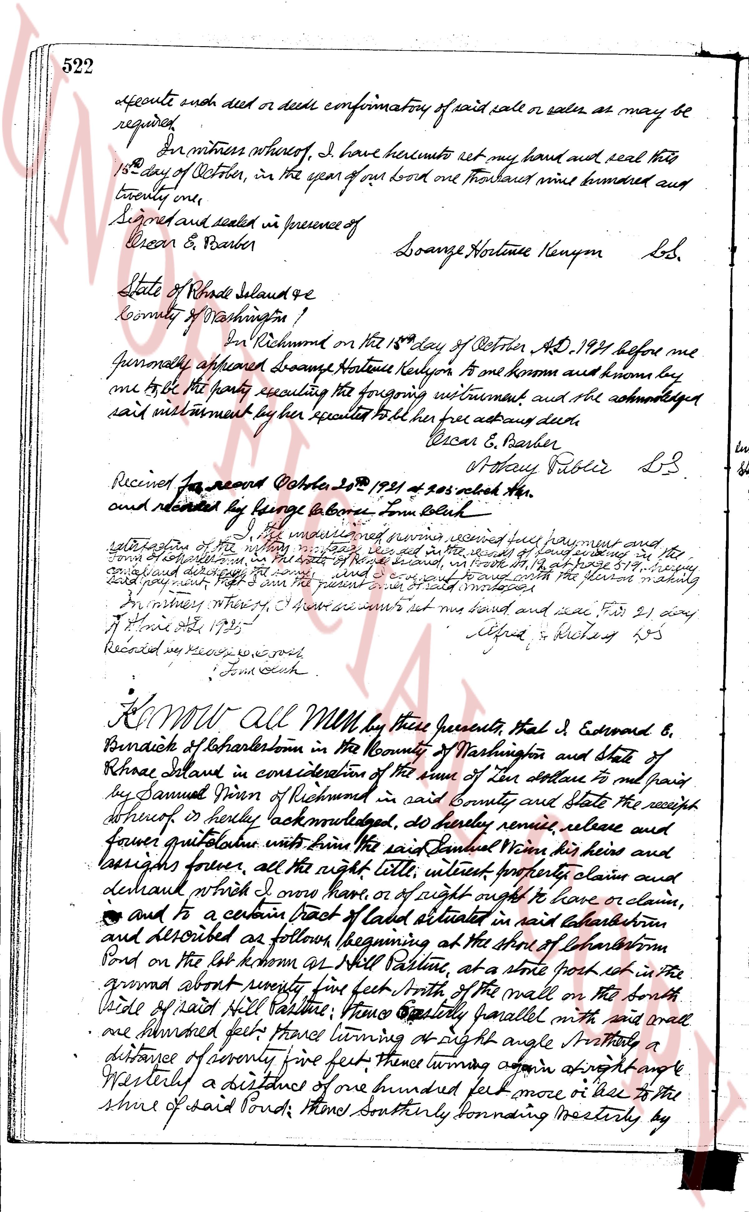
page 1

deed_walker_v1.9_2026-10-10 · the index is the town's own (i2l.uslandrecords.com); transcripts, chains and the assessor's cards are the Perry Machine's reading of it. Where the record we hold runs out, the page says so.