The instrument's own words
page 1
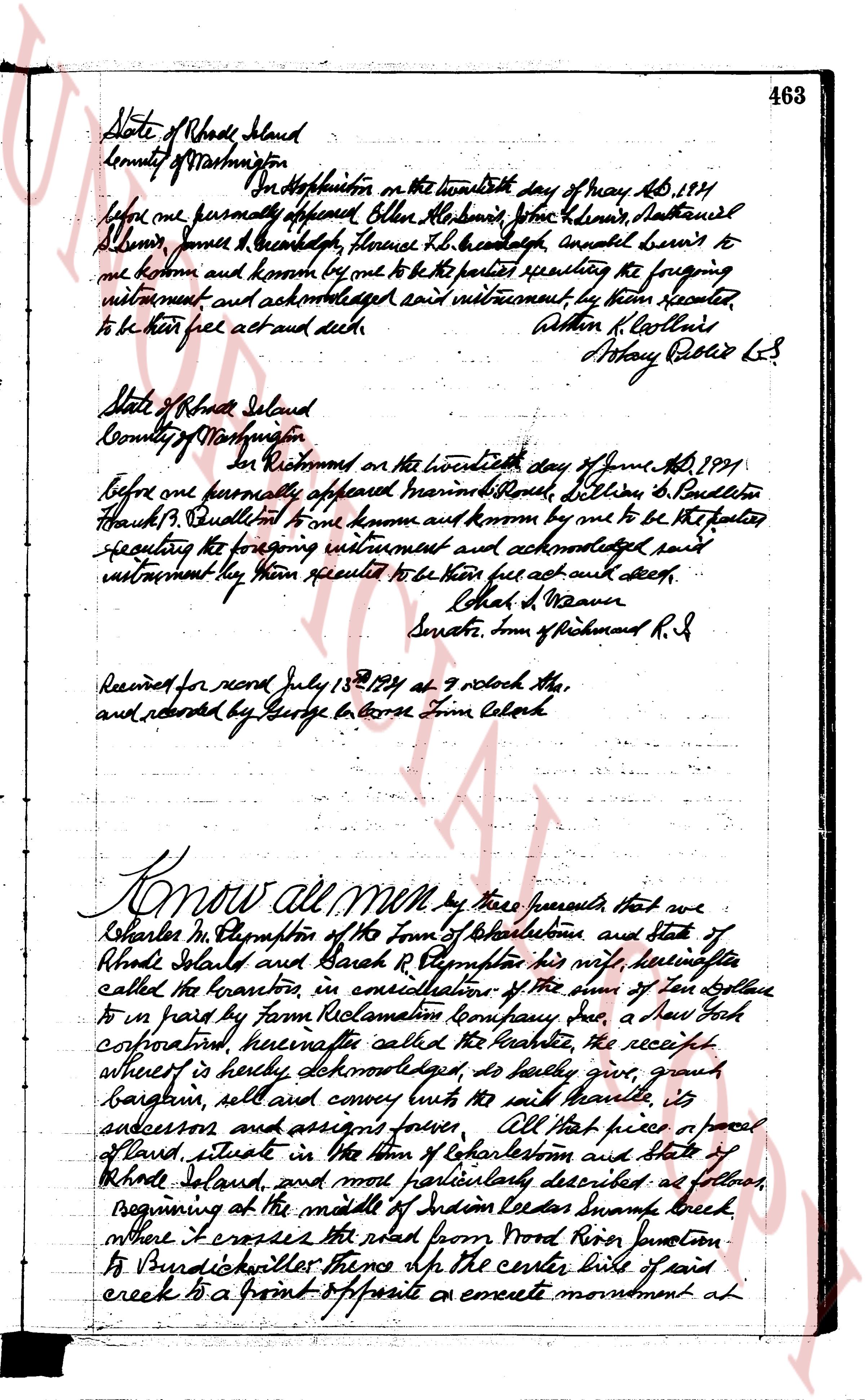
463
State of Rhode Island
County of Washington ss
In Hopkinton on the twenty sixth day of May AD 1891
before me personally appeared Oliver Allen, Barnabas Stone, Dennis, Nathaniel
Allen, James L. Beach, Florence H. L. Beach, Annabel Burns to
me known and known by me to be the parties executing the foregoing
instrument and acknowledged said instrument, by them executed
to be their free act and deed.
William H. Collins
Assistant Register LS
State of Rhode Island
County of Washington ss
In Richmond on the twenty sixth day of June AD 1891
before me personally appeared Mario R. Benell, William S. Benell
Frank J. Benell to me known and known by me to be the parties
executing the foregoing instrument and acknowledged said
instrument by them executed to be their free act and deed.
Charles D. Weaver
Senate. Inn of Richmond R. I
Received for record July 13th 1891 at 9 o'clock AM
and recorded by George G. Morse Town Clerk
Know all men by these presents that we
Charles M. Thompson of the Town of Charlestown and State of
Rhode Island and Sarah R. Thompson his wife, hereinafter
called the grantors, in consideration of the sum of ten dollars
to us paid by Farm Reclamation Company Inc, a New York
corporation, hereinafter called the grantee, the receipt
whereof is hereby acknowledged, do hereby give, grant,
bargain, sell and convey unto the said grantee, its
successors and assigns forever, All that piece of parcel
of land situate in the Town of Charlestown and State of
Rhode Island, and more particularly described as follows,
beginning at the middle of Indian Creek Swamp brook
where it crosses the road from Pond River Junction
to Burdickville thence along the center line of said
creek to a point of opposite a concrete monument at
page 2
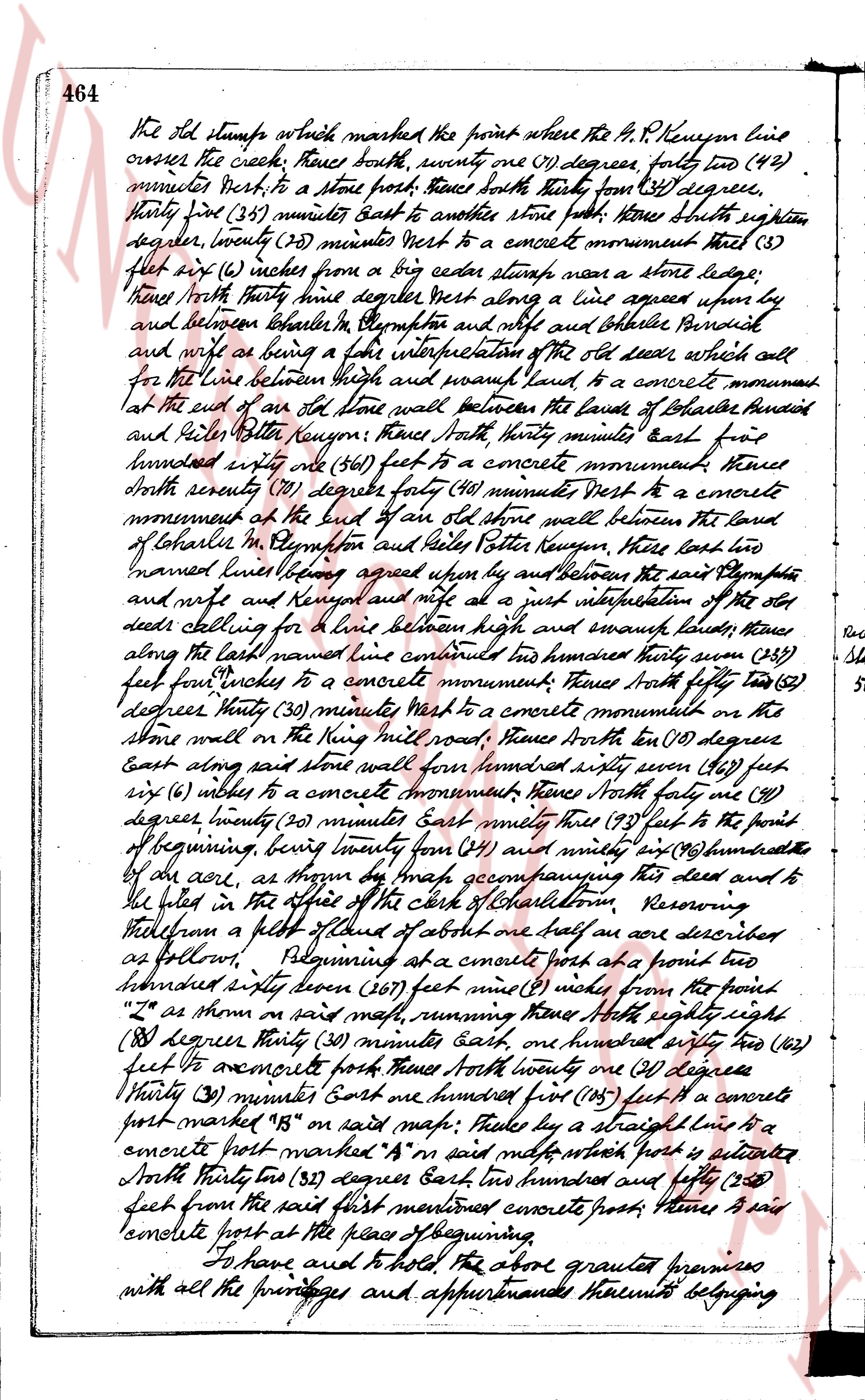
464 The old stump which marked the first point where the N.P. Railroad line
crosses the creek; thence south, seventy one (71) degrees, forty two (42)
minutes West, to a stone post; thence south thirty four (34) degree,
thirty four (34) minutes East to another stone post; thence south eighteen
degrees, twenty (20) minutes West to a concrete monument thereat three (3)
feet six (6) inches from a big cedar stump near a stone ledge;
thence North thirty nine degrees West along a line agreed upon by
and between Charles in Newport and Natalie B. Colwell Personal
and wife as being a fair interpretation of the old deed describing all
for the line between high and swamp land to a concrete monument
at the end of an old stone wall between the lands of Charles and
Natalie and Peter Kuenzen; thence North thirty minutes East five
hundred seventy one (571) feet to a concrete monument; thence
South seventy (70) degrees forty (40) minutes West to a concrete
monument at the end of an old stone wall between the land
of Charles in Newport and Peter Kuenzen; thence East ten
named lines letting agreed upon by and between the said Charles
and wife and Kuenzen and wife as a fair interpretation of the old
deeds calling for a line between high and swamp land; thence
along the marsh land running one hundred seventy three (173)
feet four inches to a concrete monument; thence South fifty two (52)
degree thirty (30) minutes West to a concrete monument on the
stone wall on the Ning mill road; thence North ten (10) degree
East along said stone wall one hundred seventy seven (177) feet,
six (6) inches to a concrete monument; thence North forty one (41)
degree, twenty (20) minutes East nearly three (3) feet to the point of
beginning, being twenty four (24) and ninety six (96) hundredths
of an acre, as shown by the map accompanying this deed and to
be filed in the office of the clerk of Charlestown. Reserving
half an acre of a plot of about half an acre described
as follows, namely, Beginning at a concrete post at a point two
hundred sixty seven (267) feet nine (9) inches from the point
"A" as shown on said map, running thence North eighty
eight (88) degrees thirty (30) minutes East, one hundred sixty two (162)
feet to concrete post; thence North forty one (41) degrees
thirty (30) minutes East one hundred five (105) feet to a concrete
post marked "B" on said map; thence by a straight line to a
concrete post marked "A" on said map, which post is entered
North thirty two (32) degrees East two hundred and fifty (250)
feet from the said first mentioned concrete post; thence a said
concrete post at the place of beginning.
To have and to hold the above granted premises
with all the privileges and appurtenances thereunto belonging
page 3
465
unto and to the use of the said grantor unto and its successors and assigns
forever. And Charles M. Plympston, one of the said grantors declares herebly for
himself and for his heirs, executors and administrators covenant with the
said trustee and its successors and assigns that he be lawfully seised in
fee simple of the said grantor premises, that the same are free from all
encumbrances, that he has good right, full power and lawful authority
to sell and convey the same in manner as aforesaid; that the said trustee
and its successors and assigns shall by these premises at all times hereafter
peaceably and quietly have and enjoy the said premises and
that he the said grantor and his heirs executors and administrators
shall warrant and defend the same to the said trustee and its
successors and assigns forever against the lawful claims and
demands of all persons. And for the consideration aforesaid
the said Sarah R. Plympston does hereby release all her right of
dower in and to the said grantor premises unto the said trustee
and its successors and assigns forever.
In witness whereof, have hereunto set our hands and
seals this 13 day of July one thousand nine hundred and twenty
one.
Received one
Stamp Signed and sealed in presence of
50¢ George LaCosse
Charles M. Plympston L.S.
Sarah R. Plympston L.S.
State of Rhode Island
County of Washington SS.
For Charlestown on the 13th day of July 1921
before me personally appeared Charles M. Plympston and
Sarah R. Plympston to me known and known by me to be the
persons named in and with executors the foregoing instrument
and each of them acknowledged said instrument by them
executed to be his and her free act and deed.
George LaCosse
Notary Public
Received for record July 19th 1921 at 9.30 o'clock a.m.
and recorded by George LaCosse Town Clerk
See next page for blank
page 4
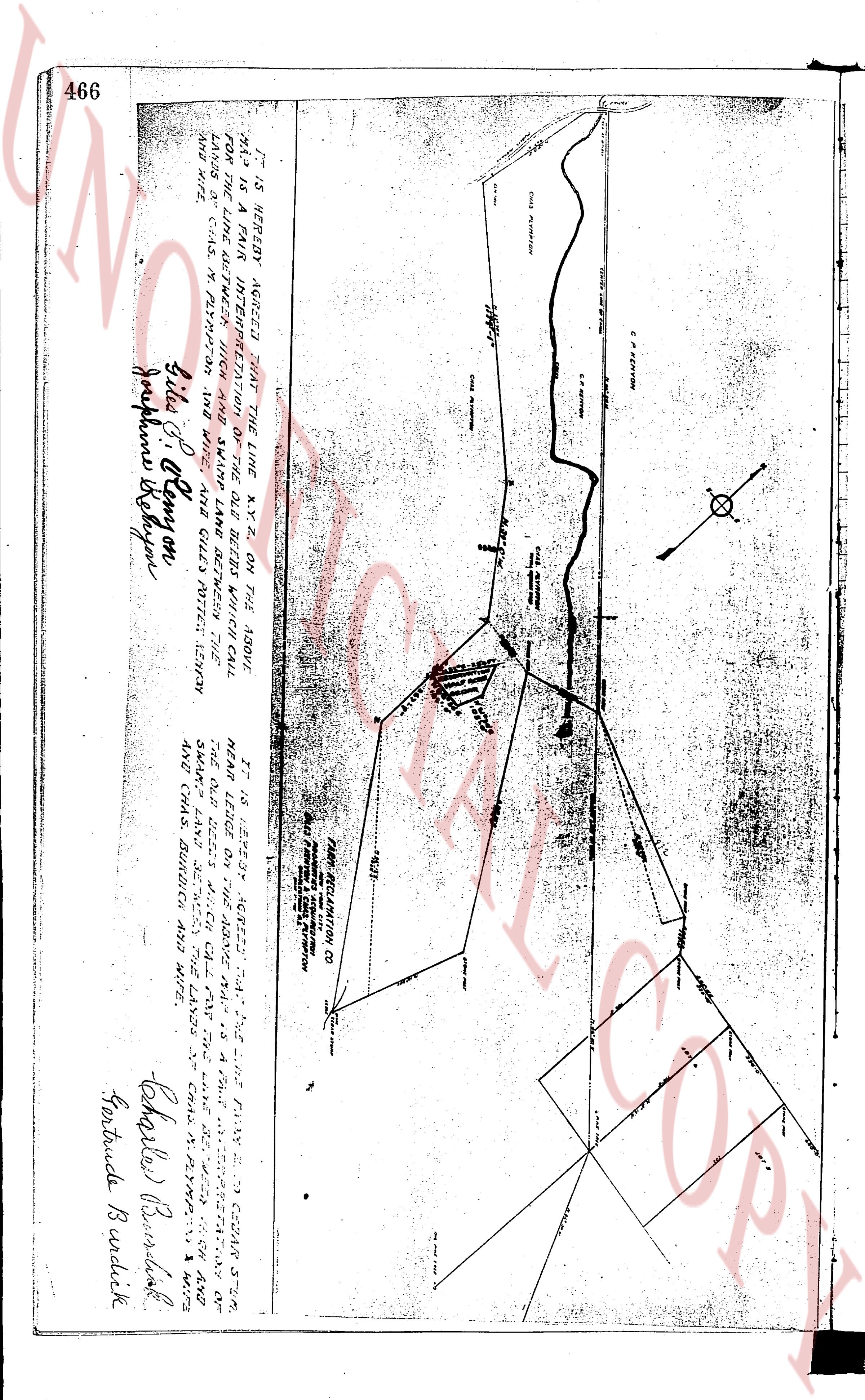
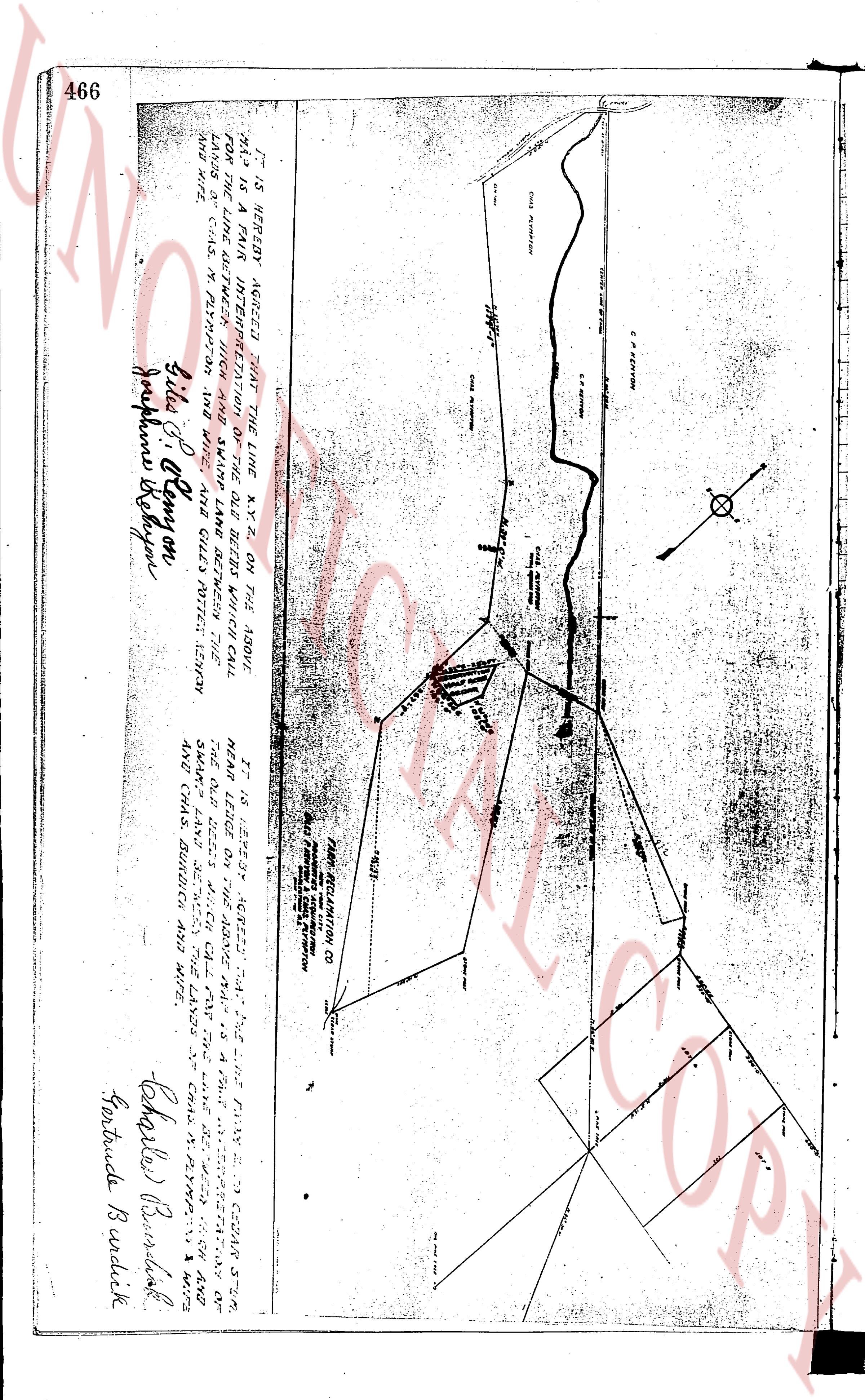
466
IT IS HEREBY AGREED THAT THE LINE K-Y-Z ON THE ABOVE
MAP IS THE TRUE INTERPRETATION OF THE OLD BEECH WHICH CALL
FOR THE LINE BETWEEN THE LANDS OF CHAS. M. PLYMPTON, AND WIFE
LANDS OF C. S. CONYON, M. PLYMPTON, AND WIFE AND IS REALLY SITUATED BETWEEN THE
LANDS AND SITE.
(Signature) Julia S. Conyon
(Signature) Josephine Beeson
IT IS HEREBY AGREED THAT THE LINE P-W-X-S TO COWAN STR.
MEAN LINE LEASED ON THE ABOVE MAP IS THE TRUE DESCRIPTION OF
THE OLD BEECH WHICH CALL FOR THE LINE DESCRIBED BETWEEN
THE LANDS OF CHAS. M. PLYMPTON, AND WIFE AND THE LANDS OF
AND CHAS. BUNDICK AND WIFE.
(Signature) Charles Bundick
(Signature) Gertrude Bundick
The page as recorded