The instrument's own words
page 1 · read by Gemma vision
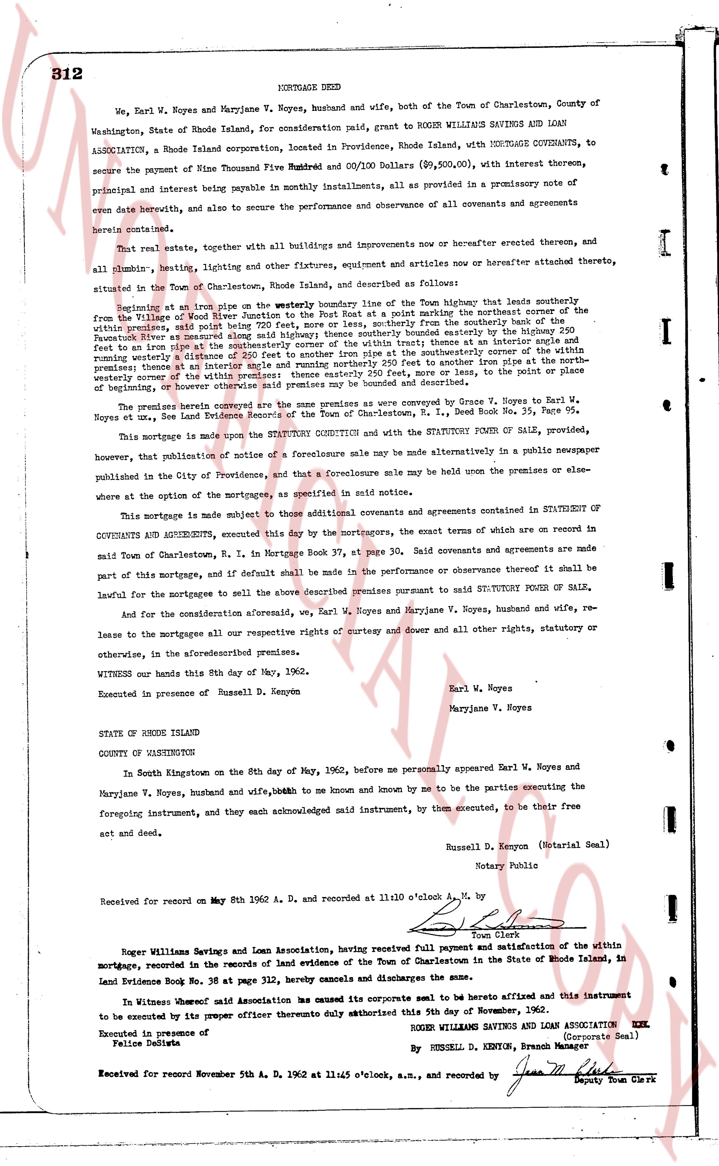
312 MORTGAGE DEED
We, Earl W. Noyes and Maryjane V. Noyes, husband and wife, both of the Town of Charlestown, County of Washington, State of Rhode Island, for consideration paid, grant to ROGER WILLIAMS SAVINGS AND LOAN ASSOCIATION, a Rhode Island corporation, located in Providence, Rhode Island, with MORTGAGE COVENANTS, to secure the payment of Nine Thousand Five Hundred Ninety and 00/100 Dollars ($9,590.00), with interest thereon, principal and interest being payable in monthly installments, all as provided in a promissory note of even date herewith, and also to secure the performance and observance of all covenants and agreements herein contained.
That real estate, together with all buildings and improvements now or hereafter erected thereon, and all plumbing, heating, lighting and other fixtures, equipment and articles now or hereafter attached thereto, situated in the Town of Charlestown, Rhode Island, and described as follows:
Beginning at an iron pipe set in the westerly boundary line of the highway that leads southerly from the Village of Ninigret River Junction to the Village of Ninigret, at the northeast corner of the within property, said point being 720 feet, more or less, southerly from the northerly bank of the within property, said point being 720 feet, more or less, southerly from the northerly bank of the within property, said point being 720 feet, more or less, southerly from the northerly bank of the within property, said point being 720 feet, more or less, southerly from the northerly bank of the within property, said point being 720 feet, more or less, southerly from the northerly bank of the within property, said point being 720 feet, more or less, southerly from the northerly bank of the within property, said point being 720 feet, more or less, southerly from the northerly bank of the within property, said point being 720 feet, more or less, southerly from the northerly bank of the within property, said point being 720 feet, more or less, southerly from the northerly bank of the within property, said point being 720 feet, more or less, southerly from the northerly bank of the within property, said point being 720 feet, more or less, southerly from the northerly bank of the within property, said point being 720 feet, more or less, southerly from the northerly bank of the within property, said point being 720 feet, more or less, southerly from the northerly bank of the within property, said point being 720 feet, more or less, southerly from the northerly bank of the within property, said point being 720 feet, more or less, southerly from the northerly bank of the within property, said point being 720 feet, more or less, southerly from the northerly bank of the within property, said point being 720 feet, more or less, southerly from the northerly bank of the within property, said point being 720 feet, more or less, southerly from the northerly bank of the within property, said point being 720 feet, more or less, southerly from the northerly bank of the within property, said point being 720 feet, more or less, southerly from the northerly bank of the within property, said point being 720 feet, more or less, southerly from the northerly bank of the within property, said point being 720 feet, more or less, southerly from the northerly bank of the within property, said point being 720 feet, more or less, southerly from the northerly bank of the within property, said point being 720 feet, more or less, southerly from the northerly bank of the within property, said point being 720 feet, more or less, southerly from the northerly bank of the within property, said point being 720 feet, more or less, southerly from the northerly bank of the within property, said point being 720 feet, more or less, southerly from the northerly bank of the within property, said point being 720 feet, more or less, southerly from the northerly bank of the within property, said point being 720 feet, more or less, southerly from the northerly bank of the within property, said point being 720 feet, more or less, southerly from the northerly bank of the within property, said point being 720 feet, more or less, southerly from the northerly bank of the within property, said point being 720 feet, more or less, southerly from the northerly bank of the within property, said point being 720 feet, more or less, southerly from the northerly bank of the within property, said point being 720 feet, more or less, southerly from the northerly bank of the within property, said point being 720 feet, more or less, southerly from the northerly bank of the within property, said point being 720 feet, more or less, southerly from the northerly bank of the within property, said point being 720 feet, more or less, southerly from the northerly bank of the within property, said point being 720 feet, more or less, southerly from the northerly bank of the within property, said point being 720 feet, more or less, southerly from the northerly bank of the within property, said point being 720 feet, more or less, southerly from the northerly bank of the within property, said point being 720 feet, more or less, southerly from the northerly bank of the within property, said point being 720 feet, more or less, southerly from the northerly bank of the within property, said point being 720 feet, more or less, southerly from the northerly bank of the within property, said point being 720 feet, more or less, southerly from the northerly bank of the within property, said point being 720 feet, more or less, southerly from the northerly bank of the within property, said point being 720 feet, more or less, southerly from the northerly bank of the within property, said point being 720 feet, more or less, southerly from the northerly bank of the within property, said point being 720 feet, more or less, southerly from the northerly bank of the within property, said point being 720 feet, more or less, southerly from the northerly bank of the within property, said point being 720 feet, more or less, southerly from the northerly bank of the within property, said point being 720 feet, more or less, southerly from the northerly bank of the within property, said point being 720 feet, more or less, southerly from the northerly bank of the within property, said point being 720 feet, more or less, southerly from the northerly bank of the within property, said point being 720 feet, more or less, southerly from the northerly bank of the within property, said point being 720 feet, more or less, southerly from the northerly bank of the within property, said point being 720 feet, more or less, southerly from the northerly bank of the within property, said point being 720 feet, more or less, southerly from the northerly bank of the within property, said point being 720 feet, more or less, southerly from the northerly bank of the within property, said point being 720 feet, more or less, southerly from the northerly bank of the within property, said point being 720 feet, more or less, southerly from the northerly bank of the within property, said point being 720 feet, more or less, southerly from the northerly bank of the within property, said point being 720 feet, more or less, southerly from the northerly bank of the within property, said point being 720 feet, more or less, southerly from the northerly bank of the within property, said point being 720 feet, more or less, southerly from the northerly bank of the within property, said point being 720 feet, more or less, southerly from the northerly bank of the within property, said point being 720 feet, more or less, southerly from the northerly bank of the within property, said point being 720 feet, more or less, southerly from the northerly bank of the within property, said point being 720 feet, more or less, southerly from the northerly bank of the within property, said point being 720 feet, more or less, southerly from the northerly bank of the within property, said point being 720 feet, more or less, southerly from the northerly bank of the within property, said point being 720 feet, more or less, southerly from the northerly bank of the within property, said point being 720 feet, more or less, southerly from the northerly bank of the within property, said point being 720 feet, more or less, southerly from the northerly bank of the within property, said point being 720 feet, more or less, southerly from the northerly bank of the within property, said point being 720 feet, more or less, southerly from the northerly bank of the within property, said point being 720 feet, more or less, southerly from the northerly bank of the within property, said point being 720 feet, more or less, southerly from the northerly bank of the within property, said point being 720 feet, more or less, southerly from the northerly bank of the within property, said point being 720 feet, more or less, southerly from the northerly bank of the within property, said point being 720 feet, more or less, southerly from the northerly bank of the within property, said point being 720 feet, more or less, southerly from the northerly bank of the within property, said point being 720 feet, more or less, southerly from the northerly bank of the within property, said point being 720 feet, more or less, southerly from the northerly bank of the within property, said point being 720 feet, more or less, southerly from the northerly bank of the within property, said point being 720 feet, more or less, southerly from the northerly bank of the within property, said point being 720 feet, more or less, southerly from the northerly bank of the within property, said point being 720 feet, more or less, southerly from the northerly bank of the within property, said point being 720 feet, more or less, southerly from the northerly bank of the within property, said point being 720 feet, more or less, southerly from the northerly bank of the within property, said point being 720 feet, more or less, southerly from the northerly bank of the within property, said point being 720 feet, more or less, southerly from the northerly bank of the within property, said point being 720 feet, more or less, southerly from the northerly bank of the within property, said point being 720 feet, more or less, southerly from the northerly bank of the within property, said point being 720 feet, more or less, southerly from the northerly bank of the within property, said point being 720 feet, more or less, southerly from the northerly bank of the within property, said point being 720 feet, more or less, southerly from the northerly bank of the within property, said point being 720 feet, more or less, southerly from the northerly bank of the within property, said point being 720 feet, more or less, southerly from the northerly bank of the within property, said point being 720 feet, more or less, southerly from the northerly bank of the within property, said point being 720 feet, more or less, southerly from the northerly bank of the within property, said point being 720 feet, more or less, southerly from the northerly bank of the within property, said point being 720 feet, more or less, southerly from the northerly bank of the within property, said point being 720 feet, more or less, southerly from the northerly bank of the within property, said point being 720 feet, more or less, southerly from the northerly bank of the within property, said point being 720 feet, more or less, southerly from the northerly bank of the within property, said point being 720 feet, more or less, southerly from the northerly bank of the within property, said point being 720 feet, more or less, southerly from the northerly bank of the within property, said point being 720 feet, more or less, southerly from the northerly bank of the within property, said point being 720 feet, more or less, southerly from the northerly bank of the within property, said point being 720 feet, more or less, southerly from the northerly bank of the within property, said point
The page as recorded