The instrument's own words
page 1 · read by Gemma vision
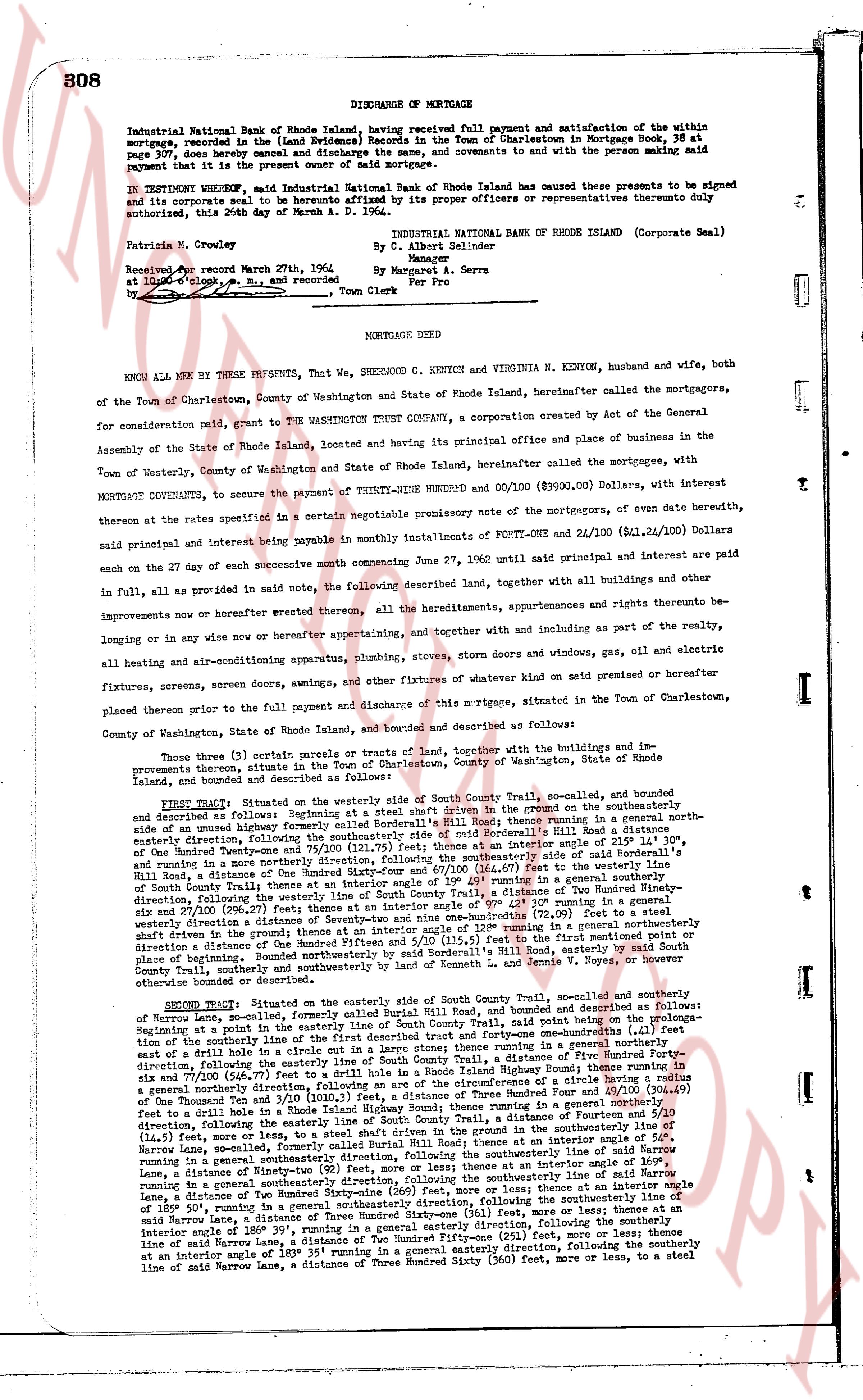
308 DISCHARGE OF MORTGAGE
Industrial National Bank of Rhode Island, having received full payment and satisfaction of the within mortgage, recorded in the Land Evidence Records of the Town of Charlestown in Mortgage Book 38 at page 307, does hereby cancel and discharge the same and covenants to and with the persons making said payment that it is the present owner and paid owner of said mortgage.
IN TESTIMONY WHEREOF, said Industrial National Bank of Rhode Island has caused these presents to be signed and its corporate seal to be affixed thereto and delivered by its proper officers or representatives thereto duly authorized, this 26th day of March A. D. 1962.
Patricia N. Crowley
By C. Albert Seldinger
By Margaret A. Serra
Per Pro
INDUSTRIAL NATIONAL BANK OF RHODE ISLAND (Corporate Seal)
Received and recorded March 27th, 1962
at 10 o'clock, a.m., R. and recorded by
Town Clerk
----
MORTGAGE DEED
KNOW ALL MEN BY THESE PRESENTS, That we, SHERWOOD C. KENYON & VIRGINIA N. KENYON, husband and wife, both of the Town of Charlestown, County of Washington and State of Rhode Island, hereinafter called the mortgagors, for consideration said paid, grant to THE WASHINGTON TRUST COMPANY, a corporation created by Act of the General Assembly of the State of Rhode Island, located and having its principal office and place of business in the Town of Westerly, County of Washington and State of Rhode Island, hereinafter called the mortgagees, with interest MORTGAGE COVENANTS, to secure the payment of THIRTY-NINE HUNDRED $ 00/100 ($3900.00) Dollars, with interest thereon at the rates specified in a certain separate promissory note modifying of the mortgage, of even date herewith, said principal and interest being payable by monthly installments of FORTY ONE AND 24/100 ($41.24) Dollars with interest on the 27th day of each month successive commencing June 27, 1962 until said principal and interest are paid in full, as provided in aid note, the following described land, together with all buildings and other improvements now or hereafter erected thereon, all the hereditaments, appurtenances, rights and tenements therebelonging or in any wise now or hereafter belonging, appertaining, and together with and including as part of the realty, all heating and air-conditioning apparatus, plumbing, stoves, storm doors and windows, gas, oil and electric fixtures, screens, sewers drain awnings, and other fixtures of whatever kind on said premises or hereafter placed thereon prior to the full payment and discharge of this mortgage, situated in the Town of Charlestown, County of Washington, State of Rhode Island, bounded and described as follows:
Those three (3) certain parcels or tracts of land, together with the buildings and improvements thereon, situate in the Town of Charlestown, County of Washington, State of Rhode Island, bounded and described as follows:
FIRST TRACT: Situated on the westerly side of South County Trail, so-called and sundry highways thereafter, formerly called Rural Hill Road, bounded and described as follows: Beginning at a point set in the southerly shaft driven in the ground on the southeasterly side of the highway known as South County Trail, then running in a general easterly direction along the southeasterly side of said Rural Hill Road a distance of 30° north, One Hundred Twenty-nine and 71/100 ($129.71) feet to a stone wall, and then running in a general southeasterly direction, following the southeasterly side of said Rural Hill Road a distance of 180° North, One Hundred Fifty-four and 67/100 ($154.67) feet to a stake, and then running in a general southeasterly direction, following the westerly line of South County Trail, a distance of 230° running in a general southeasterly direction, following the westerly line of South County Trail, a distance of 230° running in a general southeasterly direction, following the westerly line of South County Trail, a distance of 230° running in a general southeasterly direction, following the westerly line of South County Trail, a distance of 230° running in a general southeasterly direction, following the westerly line of South County Trail, a distance of 230° running in a general southeasterly direction, following the westerly line of South County Trail, a distance of 230° running in a general southeasterly direction, following the westerly line of South County Trail, a distance of 230° running in a general southeasterly direction, following the westerly line of South County Trail, a distance of 230° running in a general southeasterly direction, following the westerly line of South County Trail, a distance of 230° running in a general southeasterly direction, following the westerly line of South County Trail, a distance of 230° running in a general southeasterly direction, following the westerly line of South County Trail, a distance of 230° running in a general southeasterly direction, following the westerly line of South County Trail, a distance of 230° running in a general southeasterly direction, following the westerly line of South County Trail, a distance of 230° running in a general southeasterly direction, following the westerly line of South County Trail, a distance of 230° running in a general southeasterly direction, following the westerly line of South County Trail, a distance of 230° running in a general southeasterly direction, following the westerly line of South County Trail, a distance of 230° running in a general southeasterly direction, following the westerly line of South County Trail, a distance of 230° running in a general southeasterly direction, following the westerly line of South County Trail, a distance of 230° running in a general southeasterly direction, following the westerly line of South County Trail, a distance of 230° running in a general southeasterly direction, following the westerly line of South County Trail, a distance of 230° running in a general southeasterly direction, following the westerly line of South County Trail, a distance of 230° running in a general southeasterly direction, following the westerly line of South County Trail, a distance of 230° running in a general southeasterly direction, following the westerly line of South County Trail, a distance of 230° running in a general southeasterly direction, following the westerly line of South County Trail, a distance of 230° running in a general southeasterly direction, following the westerly line of South County Trail, a distance of 230° running in a general southeasterly direction, following the westerly line of South County Trail, a distance of 230° running in a general southeasterly direction, following the westerly line of South County Trail, a distance of 230° running in a general southeasterly direction, following the westerly line of South County Trail, a distance of 230° running in a general southeasterly direction, following the westerly line of South County Trail, a distance of 230° running in a general southeasterly direction, following the westerly line of South County Trail, a distance of 230° running in a general southeasterly direction, following the westerly line of South County Trail, a distance of 230° running in a general southeasterly direction, following the westerly line of South County Trail, a distance of 230° running in a general southeasterly direction, following the westerly line of South County Trail, a distance of 230° running in a general southeasterly direction, following the westerly line of South County Trail, a distance of 230° running in a general southeasterly direction, following the westerly line of South County Trail, a distance of 230° running in a general southeasterly direction, following the westerly line of South County Trail, a distance of 230° running in a general southeasterly direction, following the westerly line of South County Trail, a distance of 230° running in a general southeasterly direction, following the westerly line of South County Trail, a distance of 230° running in a general southeasterly direction, following the westerly line of South County Trail, a distance of 230° running in a general southeasterly direction, following the westerly line of South County Trail, a distance of 230° running in a general southeasterly direction, following the westerly line of South County Trail, a distance of 230° running in a general southeasterly direction, following the westerly line of South County Trail, a distance of 230° running in a general southeasterly direction, following the westerly line of South County Trail, a distance of 230° running in a general southeasterly direction, following the westerly line of South County Trail, a distance of 230° running in a general southeasterly direction, following the westerly line of South County Trail, a distance of 230° running in a general southeasterly direction, following the westerly line of South County Trail, a distance of 230° running in a general southeasterly direction, following the westerly line of South County Trail, a distance of 230° running in a general southeasterly direction, following the westerly line of South County Trail, a distance of 230° running in a general southeasterly direction, following the westerly line of South County Trail, a distance of 230° running in a general southeasterly direction, following the westerly line of South County Trail, a distance of 230° running in a general southeasterly direction, following the westerly line of South County Trail, a distance of 230° running in a general southeasterly direction, following the westerly line of South County Trail, a distance of 230° running in a general southeasterly direction, following the westerly line of South County Trail, a distance of 230° running in a general southeasterly direction, following the westerly line of South County Trail, a distance of 230° running in a general southeasterly direction, following the westerly line of South County Trail, a distance of 230° running in a general southeasterly direction, following the westerly line of South County Trail, a distance of 230° running in a general southeasterly direction, following the westerly line of South County Trail, a distance of 230° running in a general southeasterly direction, following the westerly line of South County Trail, a distance of 230° running in a general southeasterly direction, following the westerly line of South County Trail, a distance of 230° running in a general southeasterly direction, following the westerly line of South County Trail, a distance of 230° running in a general southeasterly direction, following the westerly line of South County Trail, a distance of 230° running in a general southeasterly direction, following the westerly line of South County
page 2 · read by Gemma vision
309
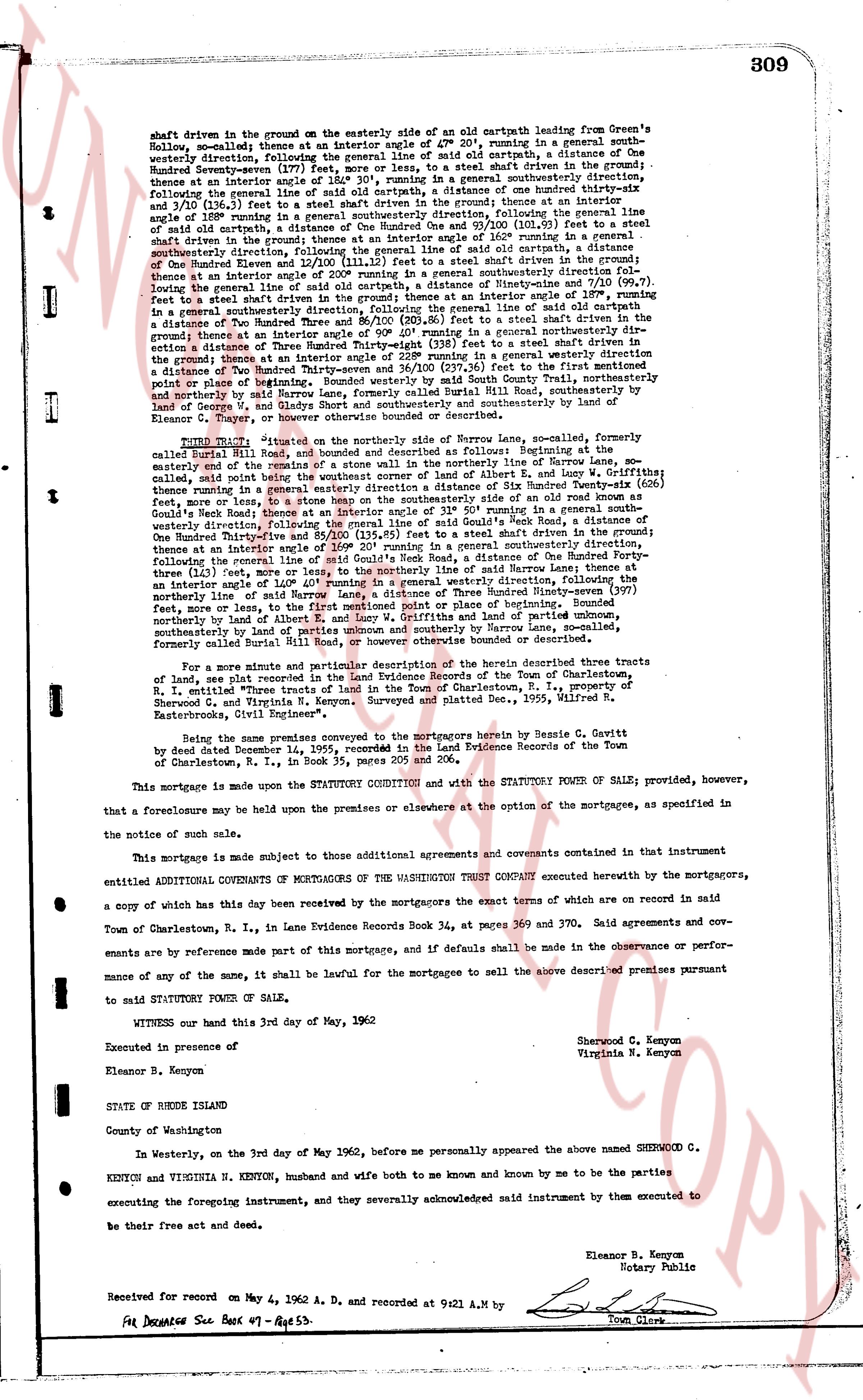
shaft driven in the ground on the easterly side of an old cartpath leading from Green's Hollow, so-called; thence at an interior angle of 40° 0' running in a general southeasterly direction, following the center line of said old cartpath, a distance of One Hundred Seventy-seven (177) feet, more or less, to a steel shaft driven in the ground; thence at an interior angle of 140° 0' running in a general northwesterly direction, following the former general line of side of old cartpath, a distance of one hundred thirty-six and 10/100 (136.10) feet, a street shaft driven in the ground; thence at an interior angle of 180° 0' running in a general northeasterly direction, following the side of said old cartpath, a distance of One Hundred One and 93/100 (101.93) feet to a steel shaft driven in the ground; thence at an interior angle of 160° 20' running in a general southeasterly direction, following the general line of side of old cartpath, a distance of One Hundred Eleven (111) feet to a steel shaft driven in the ground; thence at an interior angle of 200° running in a general southeasterly direction following the general line of side of old cartpath, a distance of Two Hundred Thirty-six and 7/100 (236.70) feet to a steel shaft driven in the ground; thence at an interior angle of 180° running in a general southeasterly direction, following the general line of side of old cartpath, a distance of Two Hundred Eighty-six and 10/100 (286.10) feet to a steel shaft driven in the ground; thence at an interior angle of 140° 0' running in a general northwesterly direction, following the general line of side of old cartpath, a distance of Three Hundred Thirty-eight (338) feet to a steel shaft driven in the ground; thence at an interior angle of 180° 0' running in a general northwesterly direction, a distance of Two Hundred Thirty-seven and 36/100 (237.36) feet to the first mentioned point or place of beginning. Bounded northerly by said South County Trust Company, southerly by land of George W. and Gladys Short and southeasterly by southeasterly by land of Eleanor B. Kenyon, and more or less as described.
FOURTH TRACT: "situated on the northerly side of Barrow Lane, so-called, formerly called Burril Hill Road, and bounded as described as follows: Beginning at the easterly corner of the road now known as Barrow Lane, so-called, formerly Burril Hill Road, so-called, said point being the northwest corner of lot of Albert E. and Lucy W. Griffiths; thence along the easterly line of said road, running in a general southeasterly direction, One Hundred forty-seven (147) feet, more or less, to a stone heap on the southeasterly side of an old road known as Good's Road; thence at an interior angle of 130° 0' running in a general south westerly direction, following the general line of side of Good's Road west, a distance of One Hundred Thirty-nine and 11/100 (139.11) feet to a steel shaft driven in the ground; thence at an interior angle of 160° 20' running in a general southeasterly direction, thence at an interior angle of 180° 0' running in a general southeasterly direction, a distance of Two Hundred Thirty-one (231) feet to a steel shaft driven in the ground; thence following the general line of side of Burril Hill Road, thence at an interior angle of 120° 40' running in a general northwesterly direction, following the general line of side of Burril Hill Road, a distance of Three Hundred Ninety-seven (397) feet, more or less, to the first mentioned point or place of beginning. Bounded northerly by land of either of the heirs of the estate of the late James and Sarah and land of parties unknown, southeasterly by land of parties unknown and southerly by Barrow Lane, so-called, formerly called Burril Hill Road, and more or less as described.
For a more minute and particular description of the herein described three tracts of land, see plat recorded in the Land Evidence Records of the Town of Charlestown, R.I. entitled Three tracts of land in the Town of Charlestown, R.I., property of Sherwood C. and Virginia N. Kenyon. Surveyed and platted Dec. 1955, Wilfred R. Backstroms, Civil Engineer".
Being the same premises conveyed to the mortgagors herein by Bessie G. Cavitt with deed dated December 4, 1929, recorded in the Land Evidence Records of the Town of Charlestown, R.I., in book 35, pages 205 and 206.
This mortgage is made upon the STATUTORY CONDITION and with the STATUTORY POWER OF SALE provided, however, that a foreclosure may be held upon the premises or elsewhere at the option of the mortgagee, as specified in the notice of such sale.
This mortgage is made subject to those additional agreements and covenants contained in that instrument entitled ADDITIONAL COVENANTS OF MORTGAGEES OF THE WASHINGTON TRUST COMPANY executed herewith by the mortgagors, a copy of which has this day been received by the mortgagors the exact terms of which are on record in said Town of Charlestown, R.I., in Land Evidence Records Book 34, at pages 365 and 370. Said agreements and covenants are by reference made part of this mortgage, and if defaults be made in the observance or performance of any of the same, it shall be lawful for the mortgagee to sell the above described premises pursuant to said STATUTORY POWER OF SALE.
WITNESS our hand this 3rd day of May, 1962
Executed in presence of
Eleanor B. Kenyon
STATE OF RHODE ISLAND
County of Washington
In Westerly, on the 3rd day of May 1962, before me personally appeared the above named SHERWOOD C. KENYON and VIRGINIA N. KENYON, husband and wife both to me known and by me to be the parties executing the foregoing instrument, and they severally acknowledged said instrument by them executed to be their free act and deed.
Eleanor B. Kenyon
Notary Public
Received for record on May 4, 1962 A. D. and recorded at 9:21 A.M by
For Deed Index See Book 47 - Page 53.
Town Clerk
The page as recorded