The instrument's own words
page 1 · read by Gemma vision
269
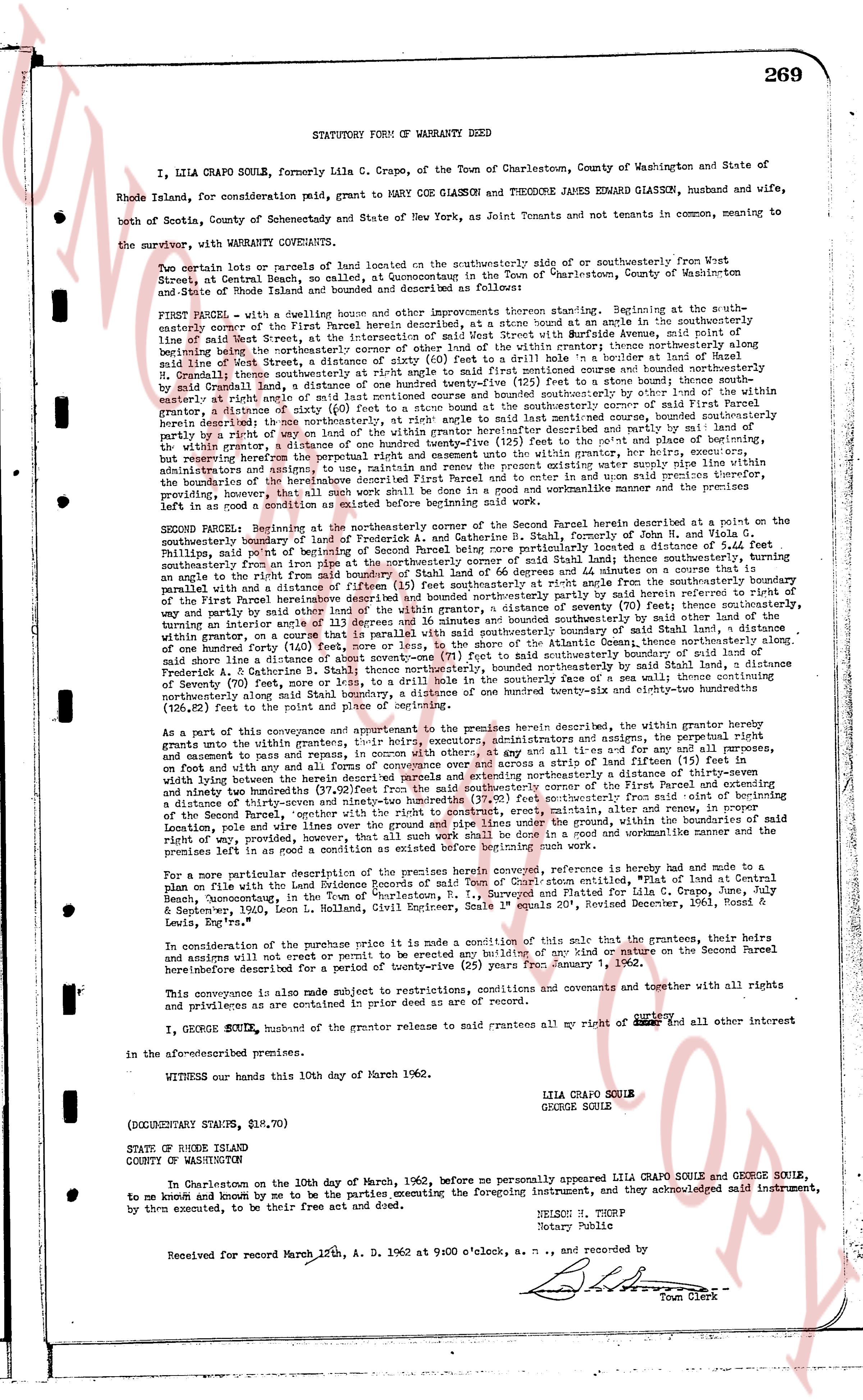
STATUTORY FORM OF WARRANTY DEED
I, LILA CRAPO SOULE, formerly Lila C. Crapo, of the Town of Charlestown, County of Washington and State of Rhode Island, for consideration paid, grant to MARY COE GLASSON and THEODORE JAMES EDWARD GLASSON, husband and wife, both of Scotia, County of Schenectady and State of New York, as Joint Tenants and not tenants in common, meaning to the survivor, with WARRANTY COVENANTS,
Two certain lots or parcels of land located on the southeasterly side of or southeasterly from West Street, at Central Beach, Quonsetpoint, in the Town of "Quonsetpoint", County of Washington and State of Rhode Island described as follows:
FIRST PARCEL - with a house only and other improvements thereon standing. Beginning at the south easterly corner of the first Parcel herein described, at a stone bound at an angle in the southeasterly line of said West Street, at the intersection of West Street with a boundary line dividing the aforementioned land lying within the northeasterly shore of the land of the within trustee thence northerly along the southeasterly line of said West Street, at the intersection of (sixty) 60 feet to a stone bound, thence easterly, to a boundary line dividing the land of the within trustee from the land of the within grantor, as described in a course oriented by said Crapo land, a distance of one hundred twenty-five (125) feet to a stone bound northerly boundary line of the land of the within trustee, thence southerly along the boundary line by a lot of the within grantor, a distance of (sixty) 60 feet to a stone bound at the southerly corner of said First Parcel herein described, thence westerly, to a boundary line dividing the land of the within trustee from the land of the within grantor, by a right of way or lot of the within grantor hereinbefore described and partly run by said lot of the within grantor, a distance of one hundred twenty-five (125) feet to the intersection of the southeasterly line of said West Street, but reserving the perpetual right entrance and exit unto the within grantor, her heirs, executors, administrators and assigns, over and across a strip of land fifteen (15) feet in width running easterly along the boundary of the heretofore described First Parcel and thence to corner and in open said within trustee providing, that all such work shall be done in a good and workmanlike manner and the premises left in as good a condition as existed before beginning said work.
SECOND PARCEL - Beginning at the northeasterly corner of the Second Parcel herein described, at a point on the southeasterly boundary of land of Frederick A. and Catherine G. Glasson, County of Kent, N. York & State of Rhode Island, said point of beginning being particularly located a distance of 5.44 feet southeasterly from an iron pipe at the northeasterly corner of said land located thence southeasterly along the boundary line of said land to a stone bound, thence easterly, to a boundary line partly parallel and with a distance of fifteen (15) feet southeastly right angle from the southeasterly boundary of the first parcel herein described, thence northerly along the boundary line by said first parcel, thence partly by a way and partly by side lots of the within grantor, a distance of seventy (70) feet; thence southeasterly, turning an obtuse angle south easterly, to a boundary line dividing the land of the within trustee from the land of the within grantor, on a course that is parallel with said southeasterly boundary of said land, a distance of one hundred forty (140) feet to a stone bound, thence westerly, to a boundary line dividing the land of the within trustee from the land of a distance of about seventy-one (71) feet to said southeasterly boundary of land of said Frederick A. and Catherine G. Glasson, thence northwesterly, to a drill hole in the westerly saw of a pea wall thence southeasterly along the boundary line to said stone bound, a distance of one hundred twenty-six and eighty-two hundredths (126.82) feet to an iron pipe at the northeasterly corner.
As a part of this conveyance and appurtenant to the premises herein conveyed, reference is hereby made and note to a plat on file with the Land Evidence records of the Town of Charlestown, entitled, "Plat of Land at Central Beach, Quonsetpoint, in the Town of "Quonsetpoint", R. I., Surveyed and Platted for Lila C. Crapo, June July & September, 1936" signed by the surveyor, "S. S. S. S. S. S. S. S. S. S. S. S. S. S. S. S. S. S. S. S. S. S. S. S. S. S. S. S. S. S. S. S. S. S. S. S. S. S. S. S. S. S. S. S. S. S. S. S. S. S. S. S. S. S. S. S. S. S. S. S. S. S. S. S. S. S. S. S. S. S. S. S. S. S. S. S. S. S. S. S. S. S. S. S. S. S. S. S. S. S. S. S. S. S. S. S. S. S. S. S. S. S. S. S. S. S. S. S. S. S. S. S. S. S. S. S. S. S. S. S. S. S. S. S. S. S. S. S. S. S. S. S. S. S. S. S. S. S. S. S. S. S. S. S. S. S. S. S. S. S. S. S. S. S. S. S. S. S. S. S. S. S. S. S. S. S. S. S. S. S. S. S. S. S. S. S. S. S. S. S. S. S. S. S. S. S. S. S. S. S. S. S. S. S. S. S. S. S. S. S. S. S. S. S. S. S. S. S. S. S. S. S. S. S. S. S. S. S. S. S. S. S. S. S. S. S. S. S. S. S. S. S. S. S. S. S. S. S. S. S. S. S. S. S. S. S. S. S. S. S. S. S. S. S. S. S. S. S. S. S. S. S. S. S. S. S. S. S. S. S. S. S. S. S. S. S. S. S. S. S. S. S. S. S. S. S. S. S. S. S. S. S. S. S. S. S. S. S. S. S. S. S. S. S. S. S. S. S. S. S. S. S. S. S. S. S. S. S. S. S. S. S. S. S. S. S. S. S. S. S. S. S. S. S. S. S. S. S. S. S. S. S. S. S. S. S. S. S. S. S. S. S. S. S. S. S. S. S. S. S. S. S. S. S. S. S. S. S. S. S. S. S. S. S. S. S. S. S. S. S. S. S. S. S. S. S. S. S. S. S. S. S. S. S. S. S. S. S. S. S. S. S. S. S. S. S. S. S. S. S. S. S. S. S. S. S. S. S. S. S. S. S. S. S. S. S. S. S. S. S. S. S. S. S. S. S. S. S. S. S. S. S. S. S. S. S. S. S. S. S. S. S. S. S. S. S. S. S. S. S. S. S. S. S. S. S. S. S. S. S. S. S. S. S. S. S. S. S. S. S. S. S. S. S. S. S. S. S. S. S. S. S. S. S. S. S. S. S. S. S. S. S. S. S. S. S. S. S. S. S. S. S. S. S. S. S. S. S. S. S. S. S. S. S. S. S. S. S. S. S. S. S. S. S. S. S. S. S. S. S. S. S. S. S. S. S. S. S. S. S. S. S. S. S. S. S. S. S. S. S. S. S. S. S. S. S. S. S. S. S. S. S. S. S. S. S. S. S. S. S. S. S. S. S. S. S. S. S. S. S. S. S. S. S. S. S. S. S. S. S. S. S. S. S. S. S. S. S. S. S. S. S. S. S. S. S. S. S. S. S. S. S. S. S. S. S. S. S. S. S. S. S. S. S. S. S. S. S. S. S. S. S. S. S. S. S. S. S. S. S. S. S. S. S. S. S. S. S. S. S. S. S. S. S. S. S. S. S. S. S. S. S. S. S. S. S. S. S. S. S. S. S. S. S. S. S. S. S. S. S. S. S. S. S. S. S. S. S. S. S. S. S. S. S. S. S. S. S. S. S. S. S. S. S. S. S. S. S. S. S. S. S. S. S. S. S. S. S. S. S. S. S. S. S. S. S. S. S. S. S. S. S. S. S. S. S. S. S. S. S. S. S. S. S. S. S. S. S. S. S. S. S. S. S. S. S. S. S. S. S. S. S. S. S. S. S. S. S. S. S. S. S. S. S. S. S. S. S. S. S. S. S. S. S. S. S. S. S. S. S. S. S. S. S. S. S. S. S. S. S. S. S. S. S. S. S. S. S. S. S. S. S. S. S. S. S. S. S. S. S. S. S. S. S. S. S. S. S. S. S. S. S. S. S. S. S. S. S. S. S. S. S. S. S. S. S. S. S. S. S. S. S. S. S. S. S. S. S. S. S. S. S. S. S. S. S. S. S. S. S. S. S. S. S. S. S. S. S. S. S. S. S. S. S. S. S. S. S. S. S. S. S. S. S. S. S. S. S. S. S. S. S. S. S. S. S. S. S. S. S. S. S. S. S. S. S. S. S. S. S. S. S. S. S. S. S. S. S. S. S. S. S. S. S. S. S. S. S. S. S. S. S. S. S. S. S. S. S. S. S. S. S. S. S. S. S. S. S. S. S. S. S. S. S. S. S. S. S. S. S. S. S. S. S. S. S. S. S. S. S. S. S. S
The page as recorded