The instrument's own words
page 1 · read by Gemma vision
233
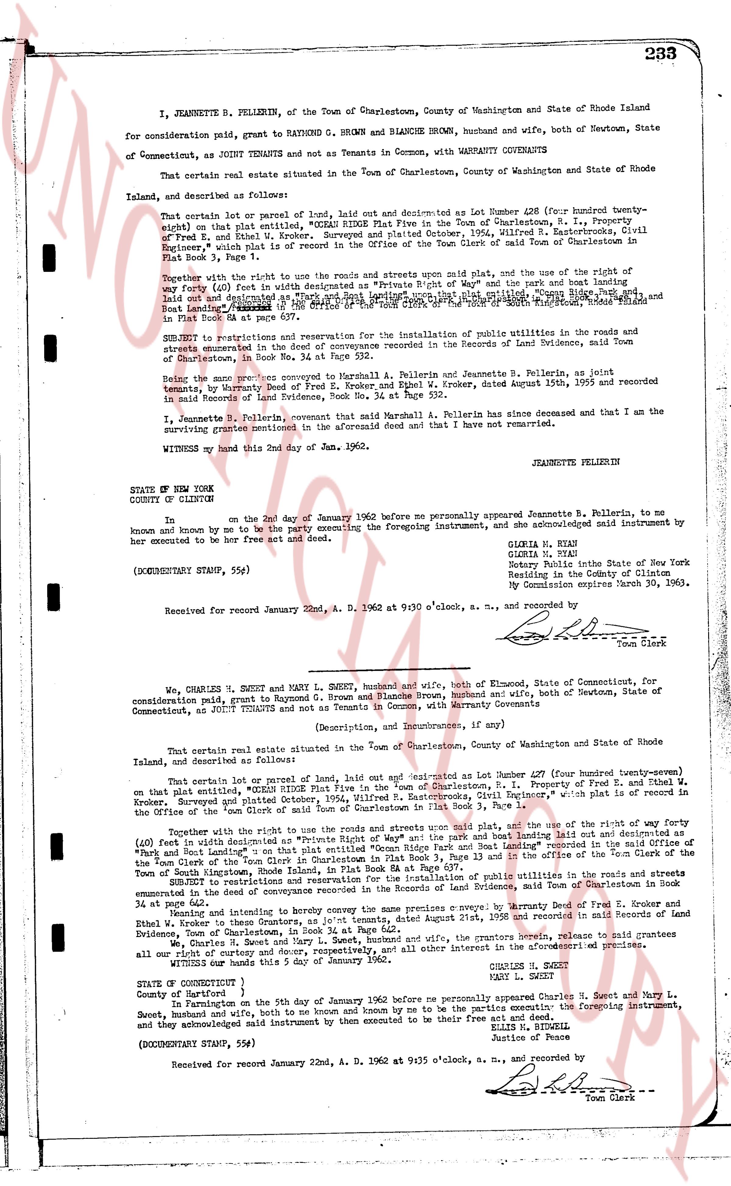
I, JEANNETTE B. PELLERIN, of the Town of Charlestown, County of Washington and State of Rhode Island for consideration paid, grant to RAYMOND G. BROWN and BLANCHE BROWN, husband and wife, both of Newtown, State of Connecticut, as JOINT TENANTS and not as Tenants in Common, with WARRANTY COVENANTS
That certain real estate situated in the Town of Charlestown, County of Washington and State of Rhode Island, and described as follows:
That certain lot or parcel of land, laid out and described as Lot Number 420 (for hundred twenty-eight) on that plat entitled, "OCEAN RIDGE PLAT Five in the Town of Charlestown, R. I., property of Fred E. and Ethel W. Kroker, Surveyed and plat filed October, 1904, Wilfred R. Easterbrook, Civil Engineer, which plat is on record in the Office of the Town Clerk of the town of South Kingstown, Rhode Island Plat Book 1, Page 1.
Together with the right to use the roads and streets shown on said plat, and the use of the right of way (forty feet) in width designated as "Private Right of Way" and the pier and boat landing laid out and described as a "pier and boat landing" shown upon that plat entitled, "Ocean Ridge Plat Five" and Boat Landing [?] recorded in the Office of the Town Clerk of the town of South Kingstown, Rhode Island Plat Book 1, Page 1.
SUBJECT to restrictions and reservation for the installation of public utilities in the roads and streets enumerated in the deed of conveyance recorded in the Records of Land Evidence, said Town of Charlestown, in Book 26, Page 111.
Being the same property conveyed to Marshall A. Pellerin and Jeannette B. Pellerin, as joint tenants, by Warranty Deed of Fred E. Kroker and Ethel W. Kroker, dated August 15th, 1955 and recorded in said Records of Land Evidence, Book No. 34 at Page 392.
I, Jeannette B. Pellerin, covenant that said Marshall A. Pellerin has since deceased and that I am the surviving grantee mentioned in the aforesaid deed and that I have not remarried.
WITNESS my hand this 2nd day of May, A.D. 1962.
JEANNETTE B PELLERIN
STATE OF NEW YORK
COUNTY OF CLINTON
In [?] on the 2nd day of January 1962 before me personally appeared Jeannette B. Pellerin, to me known and by me to be the party executing the foregoing instrument, and she acknowledged said instrument by her execution to be her free act and deed.
(DOCUMENTARY STAMP, 55¢)
Gloria N. Bean
Gloria N. Bean
Notary Public State of New York
Residing in the County of Clinton
My Commission expires March 30, 1963.
Received for record January 22nd, A. D. 1962 at 9:30 o'clock, a. m., and recorded by [Signature] Town Clerk
----
We, CHARLES H. SWEET and MARY L. SWEET, husband and wife, both of Enfield, State of Connecticut, for consideration paid, grant to Raymond G. Brown and Blanche Brown, husband and wife, both of Newtown, State of Connecticut, as JOINT TENANTS and not as Tenants in Common, with Warranty Covenants
(Description, and Incumbrances, if any)
That certain real estate situated in the Town of Charlestown, County of Washington and State of Rhode Island, and described as follows:
That certain lot or parcel of land, laid out and described as Lot Number 420 (for hundred twenty-eight) on that plat entitled, "OCEAN RIDGE PLAT Five in the Town of Charlestown, R. I. Property of Fred E. and Ethel W. Kroker, Surveyed and plat filed October, 1904, Wilfred R. Easterbrook, Civil Engineer," which plat is on record in the Office of the Town Clerk of the town of South Kingstown, Rhode Island Plat Book 1, Page 1.
Together with the right to use the roads and streets shown said plat, and the use of the right of way (40ft) feet in width designated as "Private Right of Way" and the pier and boat landing laid out and described as a "pier and boat landing" shown upon that plat entitled, "Ocean Ridge Plat Five" and Boat Landing recorded in the Office of the Town Clerk of South Kingstown, Rhode Island Plat Book 3, Page 13 and in the Office of the Town Clerk of the Town of South Kingstown, Rhode Island, Plat Book 8 at Page 13.
SUBJECT to restrictions and reservation for the installation of public utilities in the roads and streets enumerated in the deed of conveyance recorded in the Records of Land Evidence, and Town of Charlestown in Book 26 at Page 111.
Being and intending to thereby convey the same premises c. above described, by Warranty Deed of Fred E. Kroker and Ethel W. Kroker to them, dated August 15th, 1955 and recorded in said Records of Land Evidence, Town of Charlestown, in Book 34 at Page 392.
We, Charles H. Sweet and Mary L. Sweet, as owners in severalty and sole owners, the grants herein, refer to realize all our right of entry to douse and decory, respectively, and all other interest either in the aforementioned premises.
WITNESS our hands this 5 day of January, 1962.
CHARLES H. SWEET
MARY L. SWEET
STATE OF CONNECTICUT )
County of Hartford )
In Farmington on the 5th day of January 1962 before me personally appeared Charles H. Sweet and Mary L. Sweet, husband and wife, both to me known and by me to be the parties executing the foregoing instrument, and they acknowledged said instrument by their execution to be their free act and deed.
(DOCUMENTARY STAMP, 55¢)
Ellis B. Ringgold
Justice of Peace
Received for record January 22nd, A. D. 1962 at 9:35 o'clock, a. m., and recorded by [Signature] Town Clerk
The page as recorded