The instrument's own words
page 1 · read by Gemma vision
188
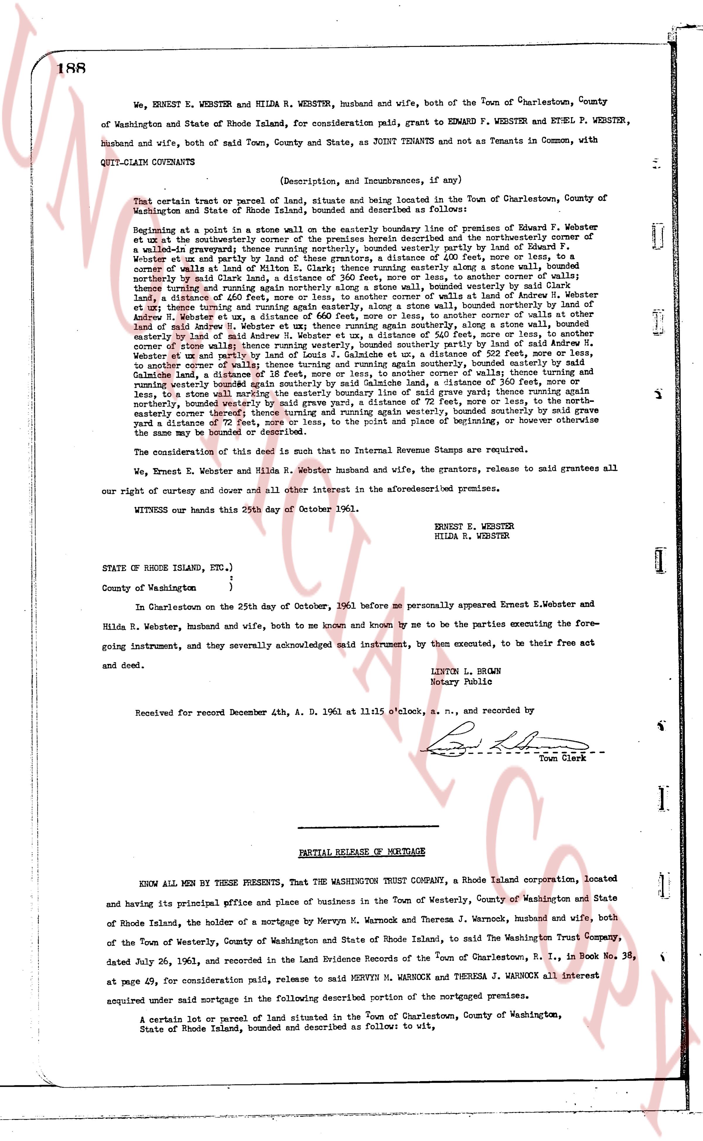
We, ERNEST E. WEBSTER and HILDA R. WEBSTER, husband and wife, both of the Town of Charlestown, County of Washington and State of Rhode Island, for consideration paid, grant to EDWARD F. WEBSTER and ETHEL P. WEBSTER, husband and wife, both of said Town, County and State, as JOINT TENANTS and not as Tenants in Common, with QUIT-CLAIM COVENANTS
(Description, and Incumbrances, if any)
That certain tract or parcel of land, situate and being located in the Town of Charlestown, County of Washington and State of Rhode Island, bounded and described as follows:
Beginning at a point in the stone wall on the easterly boundary line of premises of Edward F. Webster et ux and the northwesterly corner of the premises herein described and the northeasterly corner of by land of Edward F. Webster et ux and the northwesterly part of land of Ernest E. Webster et ux and partly by land of Ernest E. Webster et ux and partly by land of these grantors, a distance of 400 feet, more or less, to a corner of walls of Edward F. Webster et ux and the northeasterly corner of a stone wall running thence southerly marked by said Clay land, a distance of 360 feet, more or less, to another corner of walls thence turning north easterly and running along a stone wall running bounded easterly by land of Andrew H. Webster land, a distance of 460 feet, more or less, to another corner of walls at another corner of walls of Andrew H. Webster et ux, a distance of 660 feet, more or less, to another corner of walls at other corner of walls of Andrew H. Webster et ux, a distance of 460 feet, more or less, to another corner of walls at other corner of walls of Andrew H. Webster et ux, a distance of 360 feet, more or less, to a stone wall running easterly by land of Andrew H. Webster et ux, a distance of 540 feet, more or less, to another corner of walls running easterly by land of Andrew H. Webster et ux, a distance of 540 feet, more or less, to another corner of walls of Edward F. Webster et ux and partly by land of Louis J. Galimche et ux, a distance of 522 feet, more or less, to another corner of walls of Edward F. Webster et ux and partly by land of Louis J. Galimche, bounded again on the easterly by Galimche land a distance of 18 feet, more or less, to another corner of walls; thence turning and running westerly bounded again southerly by said Galimche land, a distance of 522 feet, more or less, to another corner of walls, by a stone wall and by a fence and by a road and by grave yard fence turning once again northerly, bounded westerly by said grave yard, a distance of 72 feet, more or less, to the north- easterly corner of said grave yard and thence running easterly, bounded southerly by said grave yard a distance of 72 feet, more or less, to the point and place of beginning, or however otherwise the same may be bounded on the ground.
The consideration of this deed is such that no Internal Revenue Stamps are required.
We, Ernest E. Webster and Hilda R. Webster husband and wife, the grantors, release to said grantees all our right of curtesy and dower and all other interest in the aforementioned premises.
WITNESS our hands this 25th day of October 1961.
ERNEST E. WEBSTER
HILDA R. WEBSTER
STATE OF RHODE ISLAND, ENT.)
)
County of Washington )
In Charlestown on the 25th day of October, 1961 before me personally appeared Ernest E. Webster and Hilda R. Webster, husband and wife, both to me known and by me known to be the parties executing the Fore- going instrument, and they severally acknowledged said instrument, by then executed, to be their free act and deed.
LEYTON L. BROWN
Notary Public
Received for record December 4th, A. D. 1961 at 11:15 o'clock, a. m., and recorded by
[Signature]
Town Clerk
----
PARTIAL RELEASE OF MORTGAGE
KNOW ALL MEN BY THESE PRESENTS, That THE WASHINGTON TRUST COMPANY, a Rhode Island corporation, located and having its principal office and place of business in the Town of Westerly, County of Washington and State of Rhode Island, the holder of a mortgage by Mervyn M. Warnock and Theresa J. Warnock, husband and wife, both of the Town of Westerly, County of Washington and State of Rhode Island, to said The Washington Trust Company, dated July 26, 1961, and recorded in the Land Evidence Records of the Town of Charlestown, R. I., in Book 38, at page 49, for consideration paid, release to said MERVYN M. WARNOCK and THERESA J. WARNOCK all interest acquired under said mortgage in the following described portion of the mortgaged premises.
A certain lot or parcel of land situated in the Town of Charlestown, County of Washington, State of Rhode Island, bounded and described as follow: to wit,
page 2 · read by Gemma vision
189
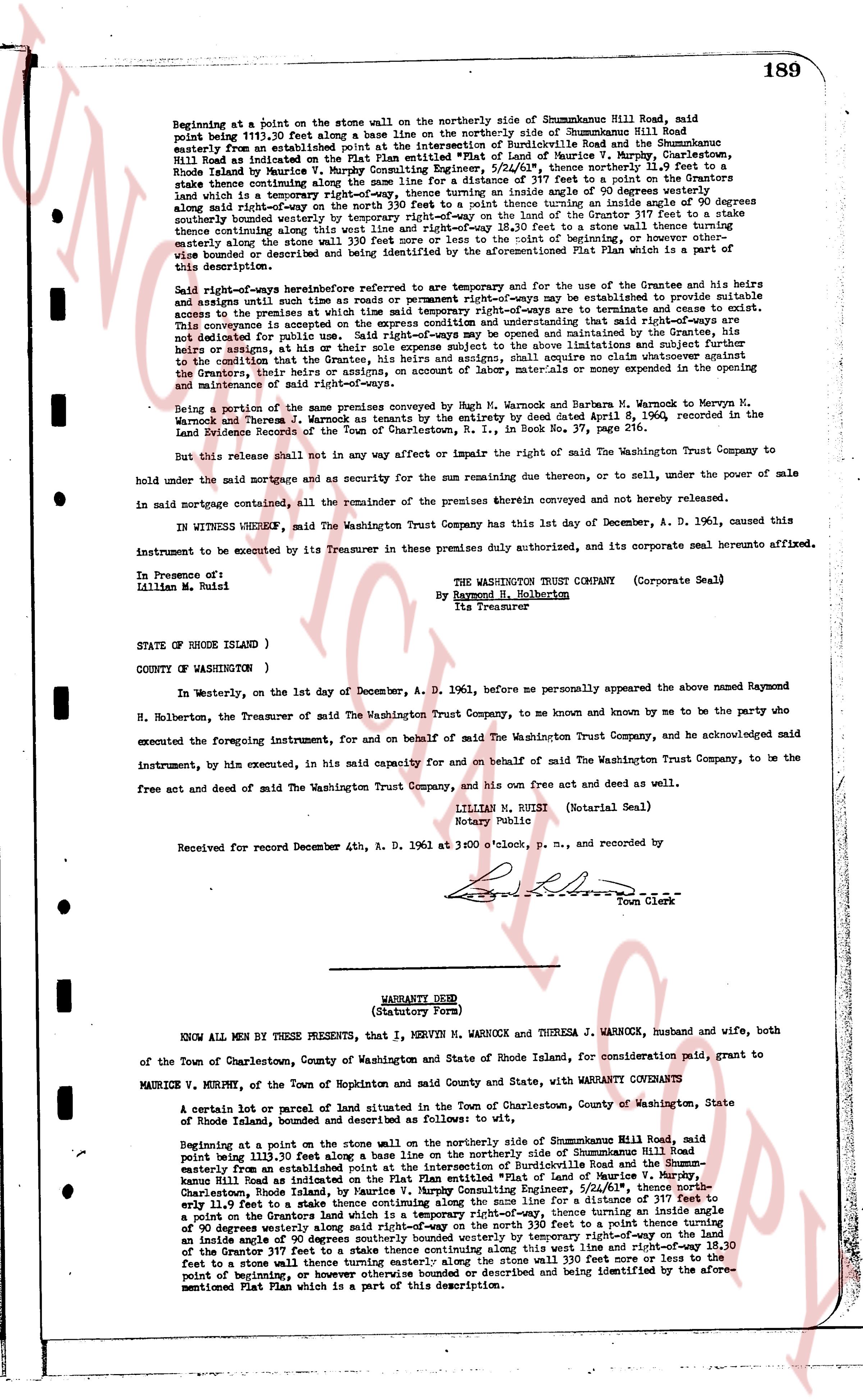
Beginning at a point on the stone wall on the northerly side of Shummunkabne Hill Road, said
point being 111.20 feet along a base line on the northerly side of Shummunkabne Hill Road,
easterly from an established point at the intersection of Burdickville Road and the Shummunkabne
Hill Road as indicated on the Plat Plan attached hereto as Exhibit A, of Maurice F. Murphy, Surveyor,
Rhode Island by Maurice V. Murphy Consulting Engineer, 5/24/61", thence northerly 11.9 feet to
a stake thence continuing along the line for a distance of 317 feet to a point (said point being a
stake) on the westerly side of a temporary right-of-way, thence turning an inside angle of 90 degrees westerly
along said right-of-way to a stake on the north 330 feet to a stake thence turning an inside angle of 90 degrees
northerly beyond westerly to a stake on the westerly side of a temporary right-of-way, thence continuing
thence continuing along this west line and right-of-way 18.30 feet to a stone wall thence turning a
stake northerly along the stone wall to a point at the northeast corner of the property, or otherwise
wise bounded or described and being identified by the aforementioned Plat Plan which is a part of this
description.
Said right-of-ways heretofore referred to are temporary and for the use of the Grantee and his heirs
until such time as roads or permanent right-of-ways are determined or available to provide suitable
access to the property of the Grantee, at which time said right-of-ways are to terminate.
This conveyance is accepted on the express condition and understanding that said right-of-ways are to
be opened, or widened, or altered or improved and maintained by the Grantee, his heirs and assigns or
others, as assigns or all the his sole expense subject to the above limitations and subject further to
the condition that the Grantee, his heirs and assigns, shall acquire no claim whatever as to the title or
ownership of the Grantor, their heirs and assigns, nor any claim for money or expenses incurred in the
opening and maintenance of said right-of-ways.
Being a portion of the same premises conveyed by Sgt. Warnock and Barbara M. Warnock to Mervyn M.
Warnock and Theresa J. Warnock by Quit Claim Deed by the unity deed dated April 8, 1960, recorded in the
Land Evidence Records of the Town of Charlestown, R.I., in Book No. 37, page 216.
But this release shall not in any way affect or impair the right of the Washington Trust Company to
hold under the said mortgage and as security for the sum remaining due therein, or to sell, under the power of sale
in said mortgage contained, all the remainder of the premises therein conveyed and not hereby released.
IN WITNESS WHEREOF, the Washington Trust Company has this 1st day December, A. D. 1961, caused this
instrument to be executed by its Treasurer in these premises duly authorized, and its corporate seal hereunto affixed.
In Presence of:
Idellian M. Buisi
THE WASHINGTON TRUST COMPANY (Corporate Seal)
By Raymond H. Holbertson
Its Treasurer
STATE OF RHODE ISLAND )
COUNTY OF (WASHINGTON ) )
In Westerly, on the 1st day of December, A. D. 1961, before me personally appeared the above named Raymond
H. Holbertson, the Treasurer of the said Washington Trust Company, to me known and by me to be the party who
executed the foregoing instrument, for and on behalf of said The Washington Trust Company, and he acknowledged
said instrument, by his own execution, in his said capacity for and on behalf of said The Washington Trust Company, to be the
free act and deed of said The Washington Trust Company, and his own free act and deed as well.
LILLIAN M. BUISI (Notarial Seal)
Notary Public
Received for record December 4th, A. D. 1961 at 3:00 o'clock, p. m., and recorded by
[Signature]
Town Clerk
----
WARRANTY DEED
(Statutory Form)
KNOW ALL MEN BY THESE PRESENTS, that I, MERVYN M. WARNOCK and THERESA J. WARNOCK, husband and wife, both
of the Town of Charlestown, County of Washington and State of Rhode Island, for consideration, paid to grant, to
MAURICE V. MURPHY, of the Town of Hopkinton and said County and State, with WARRANTY COVENANTS to
A certain lot of parcel or parcel of land situated in the Town of Charlestown, County of Washington, State
of Rhode Island, bounded and described as follows to wit:
Beginning at a point on the stone wall on the northerly side of Shummunkabne Hill Road, said
point being 111.20 feet along a base line on the northerly side of Shummunkabne Hill Road,
easterly from an established point at the intersection of Burdickville Road and the Shummunkabne
Hill Road as indicated on the Plat Plan attached hereto as Exhibit A, of Maurice F. Murphy, Surveyor,
Charlestown, Rhode Island, by Maurice V. Murphy Consulting Engineer, 5/24/61", thence northerly
else 11.9 feet to a stake thence continuing along the line for a distance of 317 feet to a point (said point
being a stake) on the westerly side of a temporary right-of-way, thence turning an inside angle of
90 degrees westerly along said right-of-way to a stake on the north 330 feet to a stake thence turning an
inside angle of 90 degrees northerly beyond westerly to a stake on the westerly side of a temporary
right-of-way, thence continuing along this west line and right-of-way 18.30 feet to a stone wall thence turning
a stake northerly along the stone wall to a point at the northeast corner of the property, or otherwise
wise bounded or described and being identified by the aforementioned Plat Plan which is a part of this
description.
The page as recorded