The instrument's own words
page 1 · read by Gemma vision
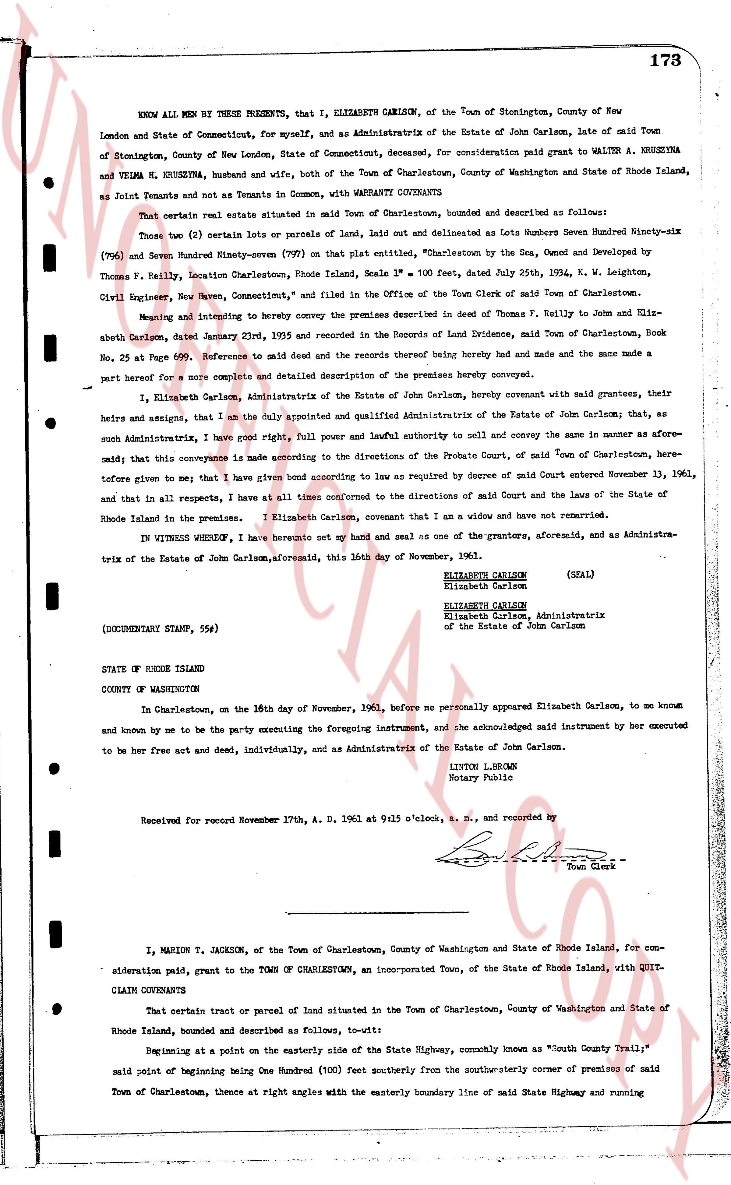
173
KNOW ALL MEN BY THESE PRESENTS, that I, ELIZABETH CARLSON, of the Town of Stonington, County of New
London and State of Connecticut, for myself, and as Administratrix of the Estate of John Carlson, late of said Town
of Stonington, County of New London, State of Connecticut, deceased, for consideration paid grant to WALTER A. KRUZINA
and VELMA N. KRUZINA, husband and wife, both of the Town of Charlestown, County of Washington and State of Rhode Island,
as Joint Tenants and not Tenants in Common, with WARRANTY CONVEYANTS
That certain real estate situated in said Town of Charlestown, bounded and described as follows:
Those two (2) certain lots or parcels of land, laid out and delineated as Lots Numbers Seven Hundred Ninety-six
(796) and Seven Hundred Ninety-seven (797) on that plat entitled, "Charlestown by the Sea, Owned and Developed by
Thomas F. Kelly, Location Charlestown, Rhode Island, Scale 1" = 100 feet, dated July 25th, 1934, by W. Leighton,
Civil Engineer, New Haven, Connecticut," and filed in the Office of the Town Clerk of said Town of Charlestown.
Meaning and intending to hereby convey the premises described in deed from Thomas F. Kelly to John and Elis-
abeth Carlson, dated January 23rd, 1955 and recorded in the Deeds of Land Evidence, said Town of Charlestown, Book
No. 25 and Page 599. Reference to said deed and the records thereof being hereby made and the same made a
part hereof for a more complete and detailed description of the premises hereby conveyed.
I, Elizabeth Carlson, Administratrix of the Estate of John Carlson, hereby covenant with said grantees, their
heirs and assigns, that I am the duly appointed and qualified Administratrix of the Estate of John Carlson; that, as
such Administratrix, I have full power and lawful authority to sell and convey the same in manner as afore-
said; that this conveyance is made according to the Directions of the Probate Court, of said Town of Charlestown, here-
tofore given to me; that I have given bond according to law as required by decree of said Court entered November 13, 1961,
and that, in all respects, I have at all times conformed to the directions of said Court and the Laws of the State of
Rhode Island in the premises. I Elizabeth Carlson, covenant that I am a widow and have not remarried.
IN WITNESS WHEREOF, I have hereunto set my hand and seal as one of the grantors, aforesaid, and as Administra-
trix of the Estate of John Carlson, aforesaid, this 16th day of November, 1961.
ELIZABETH CARLSON (SEAL)
Elizabeth Carlson
ELIZABETH CARLSON
Elizabeth Carlson, Administratrix
of the Estate of John Carlson
(DOCUMENTARY STAMP, 55¢)
STATE OF RHODE ISLAND
COUNTY OF WASHINGTON
In Charlestown, on the 16th day of November, 1961, before me personally appeared Elizabeth Carlson, to me known
and known by me to be the party executing the foregoing instrument, and acknowledged said instrument by her executed
to be her free act and deed, individually, and as Administratrix of the Estate of John Carlson.
LIBTON L. BROWN
Notary Public
Received for record November 17th, A. D. 1961 at 9:15 o'clock, a. m., and recorded by
[Signature]
Town Clerk
----
I, MARION T. JACKSON, of the Town of Charlestown, County of Washington and State of Rhode Island, for con-
sideration paid, grant to the TOWN OF CHARLESTOWN, an Incorporated Town, of the State of Rhode Island, with QUIT-
CLAIM COVENANTS
That certain tract of parcel of land situated in the Town of Charlestown, County of Washington and State of
Rhode Island, bounded and described as follows, to-wit:
Beginning at a point on the easterly side of the State Highway, commonly known as "South County Trail";
said point of beginning being One Hundred (100) feet southerly from the southwesterly corner of premises of said
Town of Charlestown, thence at right angles with the easterly boundary line of said State Highway and running
page 2 · read by Gemma vision
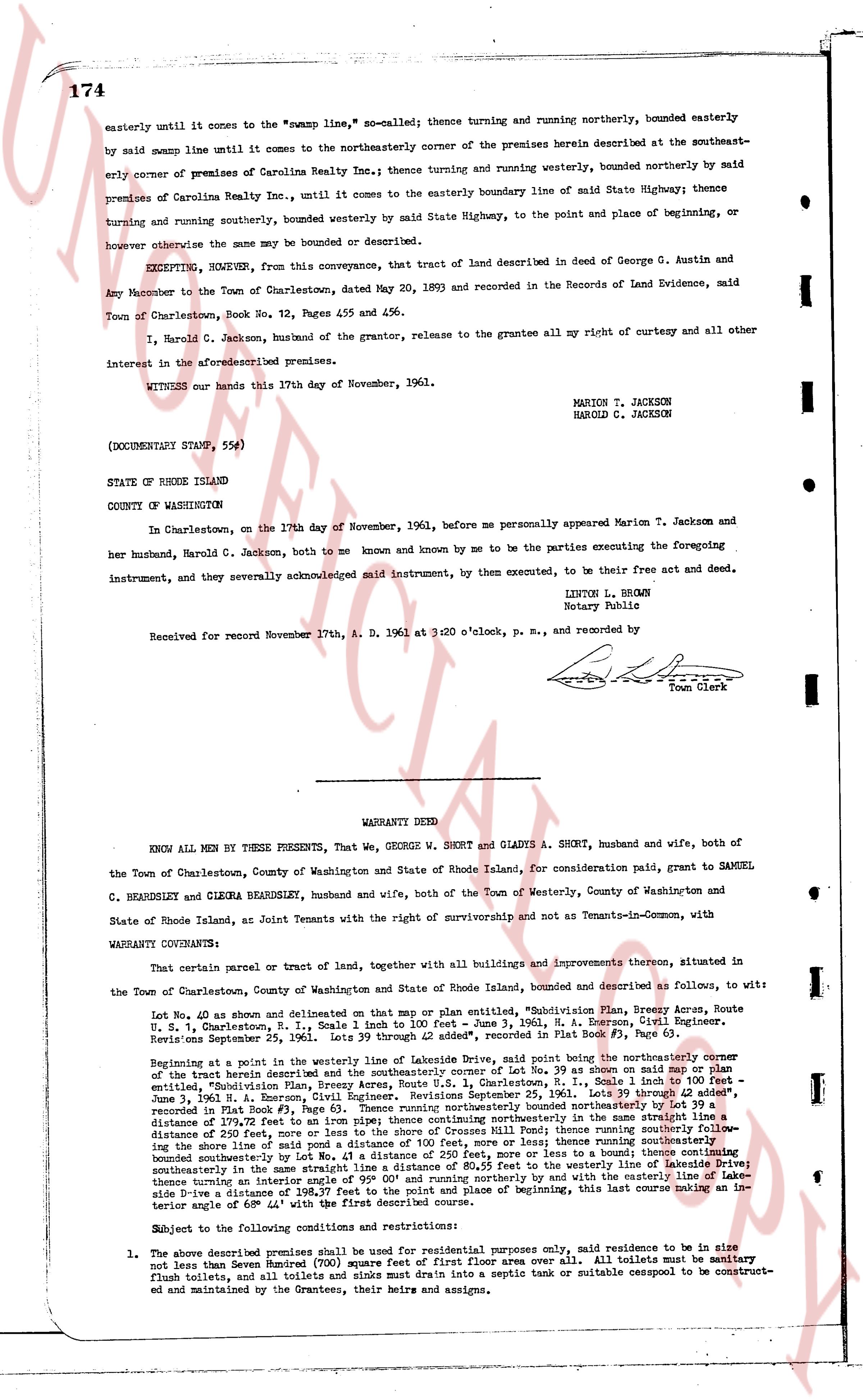
174
easterly until it comes to the "swamp line," so called; thence turning and running northerly, bounded easterly
by said swamp line until it comes to the northeasterly corner of the premises herein described at the southeast-
erly corner of premises of Carolina Realty Inc.; thence turning and running westerly, bounded northerly by said
premises of Carolina Realty Inc., until it comes to the easterly boundary line of said State Highway thence
turning and running southerly, bounded westerly by said State Highway, to the point and place of beginning, or
however otherwise the same may be bounded or described.
EXCEPTING, HOWEVER, from this conveyance, that tract of land described in deed of George C. Austin and
Amy ancestor to the Town of Charlestown, dated May 20, 1893 and recorded in the Records of Land Evidence, said
Town of Charlestown, Book No. 72, Pages 455 and 456.
I, Harold C. Jackson, husband of the grantor, release to the grantee all my right of curtesy and all other
interest in the aforesaid premises.
WITNESS our hands this 17th day of November, 1961.
MARION T. JACKSON
HAROLD C. JACKSON
(DOCUMENTARY STAMP, 55¢)
STATE OF RHODE ISLAND
COUNTY OF WASHINGTON
In Charlestown, on the 17th day of November, 1961, before me personally appeared Marion T. Jackson and
her husband, Harold C. Jackson, both to me known and known by me to be the parties executing the foregoing
instrument, by them executed, to be their free act and deed.
Instrument, and they severally acknowledged said instrument, by them executed, to be their free act and deed.
LINTON L. BROWN
Notary Public
Received for record November 17th, A. D. 1961 at 3:20 o'clock, p. m., and recorded by
[Signature]
Town Clerk
----
WARRANTY DEED
KNOW ALL MEN BY THESE PRESENTS, That, We, GEORGE W. SHORT and GLADYS A. SHORT, husband and wife, both of
the Town of Charlestown, County of Washington and State of Rhode Island, for consideration paid, grant to SAMUEL
C. BEARDSLEY and CLEMENT BEARDSLEY, husband and wife, both of the Town of Westerly, County of Washington and
State of Rhode Island, as Joint Tenants with the right of survivorship and not as Tenants-in-Common, with
WARRANTY COVENANTS:
That certain parcel or tract of land, together with all buildings and improvements thereon, situated in
the Town of Charlestown, County of Washington and State of Rhode Island, bounded and described as follows, to wit:
Lot No. 40 as shown and delineated on that map or plan entitled, "Subdivision Plan, Breezy Acres, Route
U. S. 1, Charlestown, R. I." sheet 2 of 3, dated September 29, 1961, R. I. Surveyor, June 3, 1961, R. I. Engineer,
recorded September 25, 1961, pages 39 through 42 added", recorded in Plat Book # 3, Page 63.
Beginning at a point in the westerly line of weekly Lakeside Drive, first spoke being the northeasterly corner
of the tract herein described and the northeasterly corner of Lot No. 39 as shown on said map, Scale 1 inch to 100 feet
entitled, "Subdivision Plan, Breezy Acres, Route U. S. 1, Charlestown, R. I." sheet 2 of 3, dated September 29,
June 3, 1961, H. A. Emerson, Civil Engineer, Revisions September 25, 1961, sheets 39 through 42 added",
recorded in Plat Book # 3, Page 63, thence turning and running southerly, bounded easterly by said Lakeside
distance of 197.72 feet to an iron pipe, thence turning southeasterly in the same straight line a distance 307.57
feet to an iron pipe, bounded easterly by Lot No. 39, thence turning easterly, bounded northerly by said iron
piping the shore line of said pond a distance of 100 feet, more or less; thence running southeasterly, bounded
northeasterly by said pond a distance of 100 feet, more or less; thence running southerly, bounded easterly by
said pond a distance of 100 feet, more or less; thence turning southwesterly, bounded northeasterly by said
northeasterly in the same straight line a distance of 80.25 feet to the westerly line of Lakeside Drive, thence
turning an interior angle of 180.37 degrees northerly or by with said waterline a distance of 197.72 feet, thence
side a distance of 197.72 feet to the point and place of beginning, this last course making an in-
terior angle of 68° 44' with the first described course.
Subject to the following conditions and restrictions:
1. The above described premises shall be used for residential purposes only, said residence to be in size
not larger than Seven Thousand square feet of first floor area only. All toilets must be sanitary
flush toilets, and all toilets and sinks must drain into a septic tank or suitable cesspool to be construct-
ed and maintained by the Grantees, their heirs and assigns.
The page as recorded