The instrument's own words
page 1 · read by Gemma vision
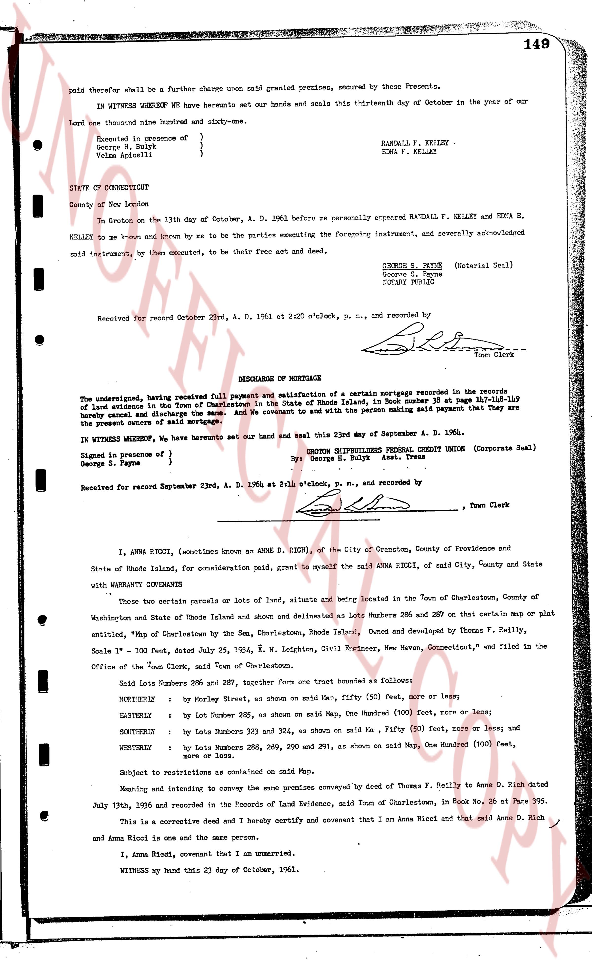
149
paid therefor shall be a further charge upon said granted premises, secured by these Presents.
IN WITNESS WHEREOF We have hereunto set our hands and seals this thirteenth day of October in the year of our Lord one thousand nine hundred and sixty-one.
Executed in presence of
George H. Bulyk }
Velma Apiccelli } RANDALL F. KELLEY
EDNA V. KELLEY
STATE OF CONNECTICUT
County of New London
In Groton on the 13th day of October, A. D. 1961 before me personally appeared RANDALL F. KELLEY and EDNA E. KELLEY, to me known and by me to be the parties executing the foregoing instrument, and severally acknowledged said instrument, to them executed, to be their free act and deed.
GEORGE S. PAYNE (Notarial Seal)
George S. Payne
NOTARY PUBLIC
Received for record October 23rd, A. D. 1961 at 2:20 o'clock, p. m., and recorded by
[Signature]
Town Clerk
----
DISCHARGE OF MORTGAGE
The undersigned, having received full payment and satisfaction of a certain mortgage recorded in the records of land evidence in the Town of Charlestown in the State of Rhode Island, in book number 35 page 114[?] 115-119 hereby release and discharge the same. And we covenant to and with the person making said payment that They are the present owners of said mortgage.
IN WITNESS WHEREOF, We have hereunto set our hand and seal this 23rd day of September A. D. 1964.
Signed in presence of
George S. Payne } GROTON CREDIT UNION (Corporate Seal)
By: George H. Bulyk Asst. Treas
Received for record September 23rd, A. D. 1964 at 2:11 o'clock, p. m., and recorded by
[Signature]
Town Clerk
----
I, ANNA RICCI, (sometimes known as ANNE D. RICH), of the City of Cranston, County of Providence and State of Rhode Island, for consideration paid, grant to myself said ANNA RICCI, of said City, County and State with WARRANTY COVENANTS Conveyance
Those two certain parcels or lots of land, situate and being located in the Town of Charlestown, County of Washington and State of Rhode Island and shown and delineated as Lots Numbers 286 and 287 on that certain map or plat entitled, "Map of Charlestown by the Sea, Charlestown, Rhode Island. Owned and developed by Thomas F. Reilly, Scale 1" = 100 Feet, dated July 25, 1924, W. H. Leichten, Civil Engineer, New Haven, Connecticut," and filed in the Office of the Town Clerk, said Town of Charlestown.
Said Lots Numbers 286 and 287, together Form one tract bounded as follows:
NORTHERLY : by Morley Street, as shown on said Map, fifty (50) feet, more or less;
EASTERLY : by Lot Number 285, as shown on said Map, One Hundred (100) feet, more or less;
SOUTHERLY : by Lots Numbers 321 and 324, as shown on said Map, a Fifty (50) feet, more or less; and
WESTERLY : by Lots Numbers 286, 289, 290 and 291, as shown on said Map, One Hundred (100) feet, more or less.
Subject to restrictions as contained on said Map.
Meaning and intending to convey the same premises conveyed by deed of Thomas F. Reilly to Anne D. Rich dated July 13th, 1936 and recorded in the Records of Land Evidence, said Town of Charlestown, in Book No. 26 at Page 395.
This is a corrective deed and I hereby certify and covenant that I am Anna Ricci and that said Anne D. Rich and Anna Ricci is one and the same person.
I, Anna Ricci, covenant that I am an unmarried.
WITNESS my hand this 23 day of October, 1961.
page 2 · read by Gemma vision
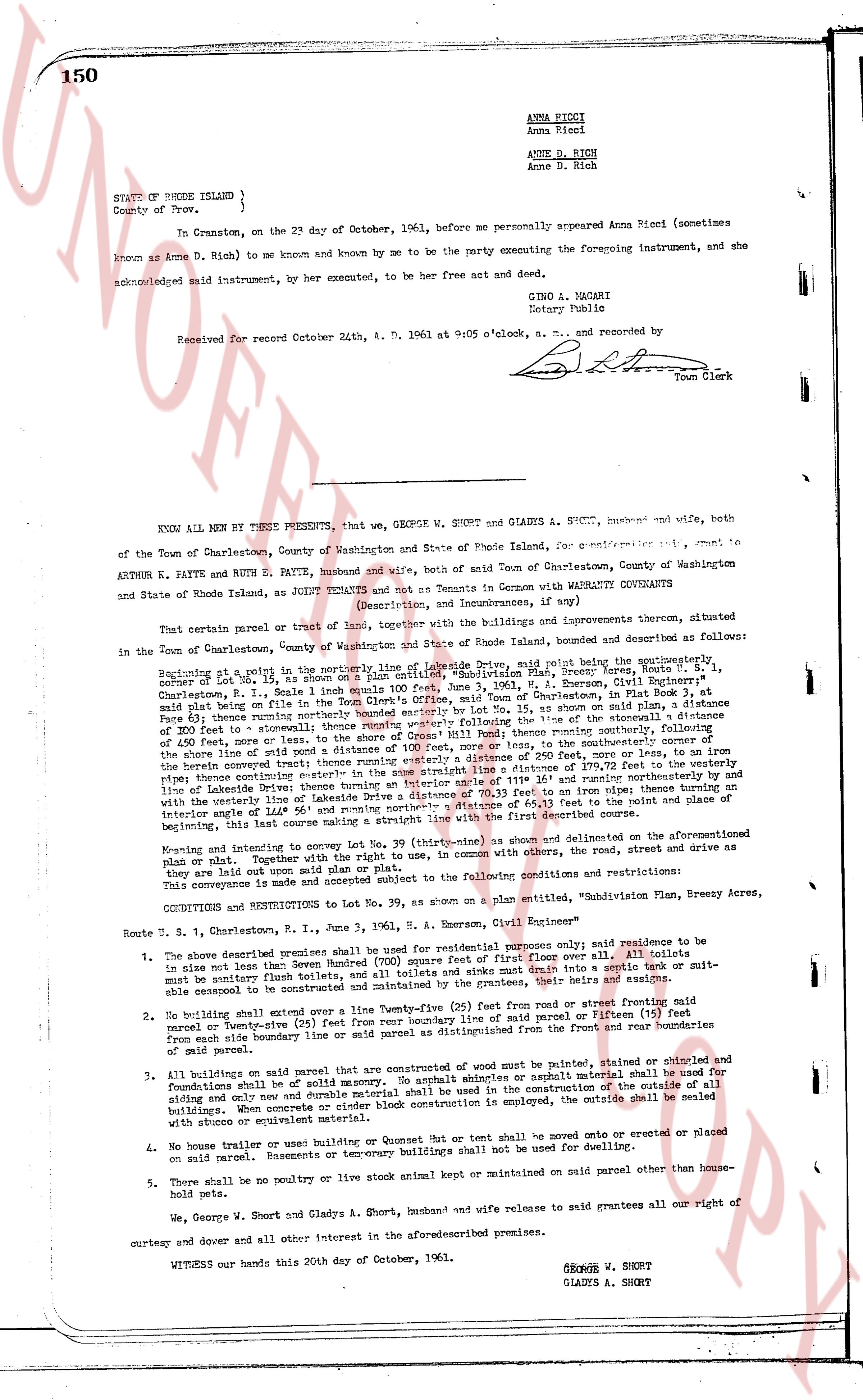
150
ANNA RICCI
Anna Ricci
ANNE D. RICH
Anne D. Rich
STATE of RHODE ISLAND }
County of Prov. }
On, Certain in the 23 day of October, 1961, before me personally appeared Anna Ricci (sometimes
known as Anne D. Rich) to me known and known by me to be the party executing the foregoing instrument, and she
acknowledged said instrument, by her executed, to be her free act and deed.
GINO A. MAGARI
Notary Public
Received for Record October 24th, A. D. 1961 at 9:05 o'clock, a. m., and recorded by
[Signature]
Town Clerk
----
KNOW ALL MEN BY THESE PRESENTS, that we, GEORGE W. SHORT and GLADYS A. SHORT, husband and wife, both
of the Town of Charlestown, County of Washington and State of Rhode Island, for consideration and grant, to
ARTHUR E. PATTE and RUTH E. PATTE, husband and wife, both of said Town of Charlestown, County of Washington
and State of Rhode Island, as JOINT TENANTS and not as Tenants in Common with MARITAL COVENANTS
(Description, and Improvements, if any)
That certain parcel of land, together with the buildings and improvements thereon, situated
in the Town of Charlestown, County of Washington and State of Rhode Island, bounded and described as follows:
Beginning at a stake in the corner of the line of the road called "Divide Road" said stake being the southwestern
corner of a lot marked "No. 39" as shown on a plat entitled, "Subdivision Plan, Branch Estate," by "A. Emerson, Civil Engineer",
Charlestown, R. I., dated June 3, 1963, a record copy of which plat being on file in the Town Clerk's Office, said Office of the Town of Charlestown, in File Book 3, page
63 (see plat being on file with the Town Clerk's Office), then running southeasterly along the road called "Divide Road"
page 63 thence running northeasterly along the running westerly following the line of the stonewall a distance
of 250 feet to a stake, then running northeasterly along the line of said stonewall a distance of 100 feet, more or
less, 450 feet, more or less, to the shore of the pond, thence running southeasterly along the shore of said pond a
distance of 100 feet, more or less, to the southeasterly corner of the herb overrun terrain; thence running easterly a distance of 100 feet, more or less, on the line of the
herb overrun terrain; thence running easterly a distance of 100 feet, more or less, to the line of the
road called "Divide Road"; thence running northwest a distance of 170.72 feet to the western margin of the
line of Lakeside Drive; thence running an interior angle of 114.34 degrees northwest a distance of 111.14 feet
and with the interior angle of 114.34 degrees running northeasterly a distance of 63.13 feet to an iron pipe; thence running an
interior angle of 114.34 degrees running northeasterly a distance of 63.13 feet to the point of place and
beginning of the above described course.
Knowing and intending to convey hereby Lot No. 39 (three ninety) as shown and delimited on the aforementioned
said plat or plan. Together with the right to use, in common, with others, the road, the street and drive as
they are laid out upon said plan. Said premises are subject to the following conditions and restrictions:
CONDITIONS and RESTRICTIONS to Lot No. 39, as shown on a plan entitled, "Subdivision Plan, Branch Estate," by
Route U. S. 1, Charlestown, R. I., dated June 3, 1963, A. Emerson, Civil Engineer"
1. The shore described premises shall be used for residential purposes only; said residence to be
not smaller than Seven Hundred (700) square feet of first floor over all; all toilets to
be sanitary type from tank or sewer; all waste pipes and drains to run into a septic tank or suit-
able cesspool to be constructed and maintained by the grantees, their heirs and assigns.
2. No building shall extend over a line Twenty-five (25) feet from the road and front property line
parcel or Twenty-five (25) feet from the side property line (said road) or Fifteen (15) feet
from each side boundary line of said parcel or mid parcel as distinguished from the front and rear boundaries
of said parcel.
3. All buildings on said parcel that are constructed of wood must be painted, stained or shingled and
foundations shall be of solid masonry. No asphalt shingles or asphalt material shall be used for
siding or any new and durable material shall be used in the construction of the walls of
buildings. When concrete or concrete block for foundations is employed, the outside shall be sealed
with stucco or equivalent material.
4. No house trailer or used building or houseboat or Tent but or tent shall be moved onto or erected or placed
on said parcel. Basements or temporary buildings shall not be used for dwelling.
5. There shall be no poultry or live stock animal kept or maintained on said parcel other than house-
hold pets.
We, George W. Short and Gladys A. Short, husband and wife release to said grantees all our right of
curtesy and dower and all other interest in the aforesaid described premises.
WITNESS our hands this 20th day of October, 1961.
GEORGE W. SHORT
GLADYS A. SHORT
The page as recorded