The instrument's own words
page 1 · read by Gemma vision
118 STATUTORY FORM OF WARRANTY DEED
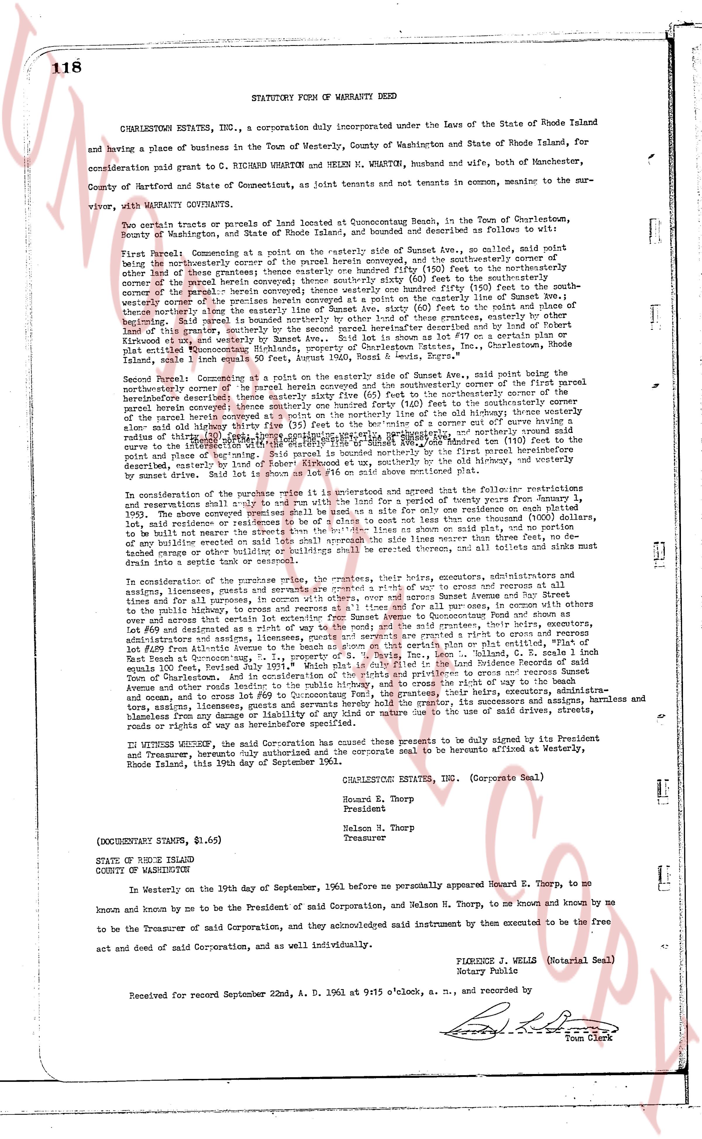
CHARLESTOWN ESTATES INC., a corporation duly incorporated under the Laws of the State of Rhode Island and having a place of business in the Town of Westerly, County of Washington and State of Rhode Island, for consideration paid grant to C RICHARD WHARTON and HELEN M. WHARTON, husband and wife, both of Manchester, County of Hartford and State of Connecticut, as joint tenants and joint tenants in common, meaning to the survivor, with WARRANTY COVENANTS.
Two certain tracts or parcels of land situated at Quonsetcong Beach, in the Town of Charlestown, County of Washington, and State of Rhode Island, bounded and described as follows to wit:
First Parcel: Commencing at a point on the easterly side of Sunset Ave., so called, said point being the northeasterly corner of the parcel herein conveyed, and the southeasterly corner of the first parcel other than the one herein conveyed; thence southerly one hundred forty (140) feet to the southerly corner of the parcel herein conveyed; thence westerly sixty six (66) feet to the southeasterly corner of the parcel herein conveyed; thence northerly one hundred forty (140) feet to the northeasterly corner of the parcel herein conveyed; thence easterly sixty six (66) feet to the point of beginning; the westerly corner of the premises herein conveyed at a point on the easterly side of Sunset Ave.; thence easterly sixty six (66) feet to the east limit of the said lot; thence northerly one hundred forty (140) feet to the north limit of the said lot; thence westerly sixty six (66) feet by other land of this grantee, easterly by other land of this grantor, southerly by the second parcel hereinabove described such lot being as shown on lot #17 on a certain plan or drawing entitled "Quonsetcong Beach, property of Charlestown Estates, Inc., Charlestown, Rhode Island" said plan being recorded in land evidence book 34, page 118.
Second Parcel: Commencing at a point on the easterly side of Sunset Ave., said point being the northeasterly corner of the parcel herein conveyed and the southeasterly corner of the first parcel hereinabove described; thence southerly one hundred forty (140) feet to the southerly corner of the first parcel herein conveyed; thence southeasterly one hundred forty (140) feet to the southeasterly corner of the parcel herein conveyed; thence westerly one hundred forty (140) feet to the southwesterly corner of said lot; along said westerly thirty five (35) feet to the beginning of an arc of curve cutting outward have a radius of thirty five (35) feet; thence along said arc to the easterly side of Sunset Ave., thence northerly one (110) feet to the point of beginning; the said second parcel being bounded on the north by the first parcel, on the east by property described as "Lot #18 of Robert Howard et ux", southerly by the old highway, and westerly by sunset drive. Said lot is shown as lot #16 on said above mentioned plan.
In consideration of the purchase price its unrestricted and agreed with the following restrictions and reservations shall be and remain in full force and effect until the expiration of twenty years from January 1, 1965. The above conveyed premises shall be used as a site for only one residence not exceeding 1,000 square feet in size, and said residence shall not be sold for more than one thousand (1000) dollars, to be built not nearer the streets than the abutments the building lines as shown on plan and plot, no partition fence shall be erected on the property, no livestock shall be kept on the premises, no garbage burned in trashage cans or other combustible buildings shall be erected therefore, and all toilets and sinks must be drained into a septic tank or cesspool.
In consideration of the purchase price the grantor, the grantees, their successors, executors and administrators assigns, licensees, grantees, users and grantees are granted a right of way to pass and cross and recurses at all times, and for all purposes in public, to access to and from the easterly side of Sunset Avenue from the street and to the public highway, to access to and from the first parcel forty (40) feet wide and for all purposes, in common with others and across that certain lot entitled "Lot #15 of Robert Howard et ux" at Quonsetcong Beach, and for all purposes, in common with others and across that certain lot entitled "Lot #69 of Quonsetcong Beach, E. P., property of S. I. Tracy, Inc." Lee, the said right of way being forty (40) feet wide and as shown on the plan or plot entitled, "Plat of Lot #69 of Quonsetcong Beach, E. P., property of S. I. Tracy, Inc." recorded in the Land Evidence Records of said East Beach at Quonsetcong, E. P., property of S. I. Tracy, Inc. Lee, the said grantors, their heirs, executors, administrators and assigns, licensees, grantees, users and grantees are granted a right of way to pass and cross and recurse Sunset Avenue and other public roads, and the right of way to pass and cross the beach and the high water mark to the ocean, and in consideration of the rights and privileges to access and recurse Sunset Avenue and other public roads, and the right of way to pass and cross the beach and the high water mark to the ocean, the grantor, their heirs, executors, administrators and assigns, licensees, grantees, users and grantees are held harmless and blameless from any damage or liability of any kind or nature one to the said of drive streets, roads, towage and access, limit of roads or way of highways hereinabove specified.
IN WITNESS WHEREOF, the said Grantor has caused these presents to be duly signed by its President and Treasurer, pursuant to the bylaws of said Corporation and the corporate seal to be hereunto affixed at Westerly, Rhode Island, this 19th day of September 1961.
CHARLESTOWN ESTATES INC. (Corporate Seal)
Howard E. Thorp
President
Nelson H. Thorp
Treasurer
(DOCUMENTARY STAMPS, $1.65)
STATE OF RHODE ISLAND
COUNTY OF WASHINGTON
In Westerly on the 19th day of September, 1961 before me personally appeared Howard E. Thorp, to me known and known by me to be the President of said Corporation, and Nelson H. Thorp, to me known and known by me to be the Treasurer of said Corporation, and they acknowledged said instrument than executed to be the free act and deed of said Corporation, and as well individually.
FLORENCE A. WELLS (Notarial Seal)
Notary Public
Received for record September 22nd, A. D. 1961 at 9:15 o'clock, a. m., and recorded by
[Signature]
Town Clerk
The page as recorded