The instrument's own words
page 1 · read by Gemma vision
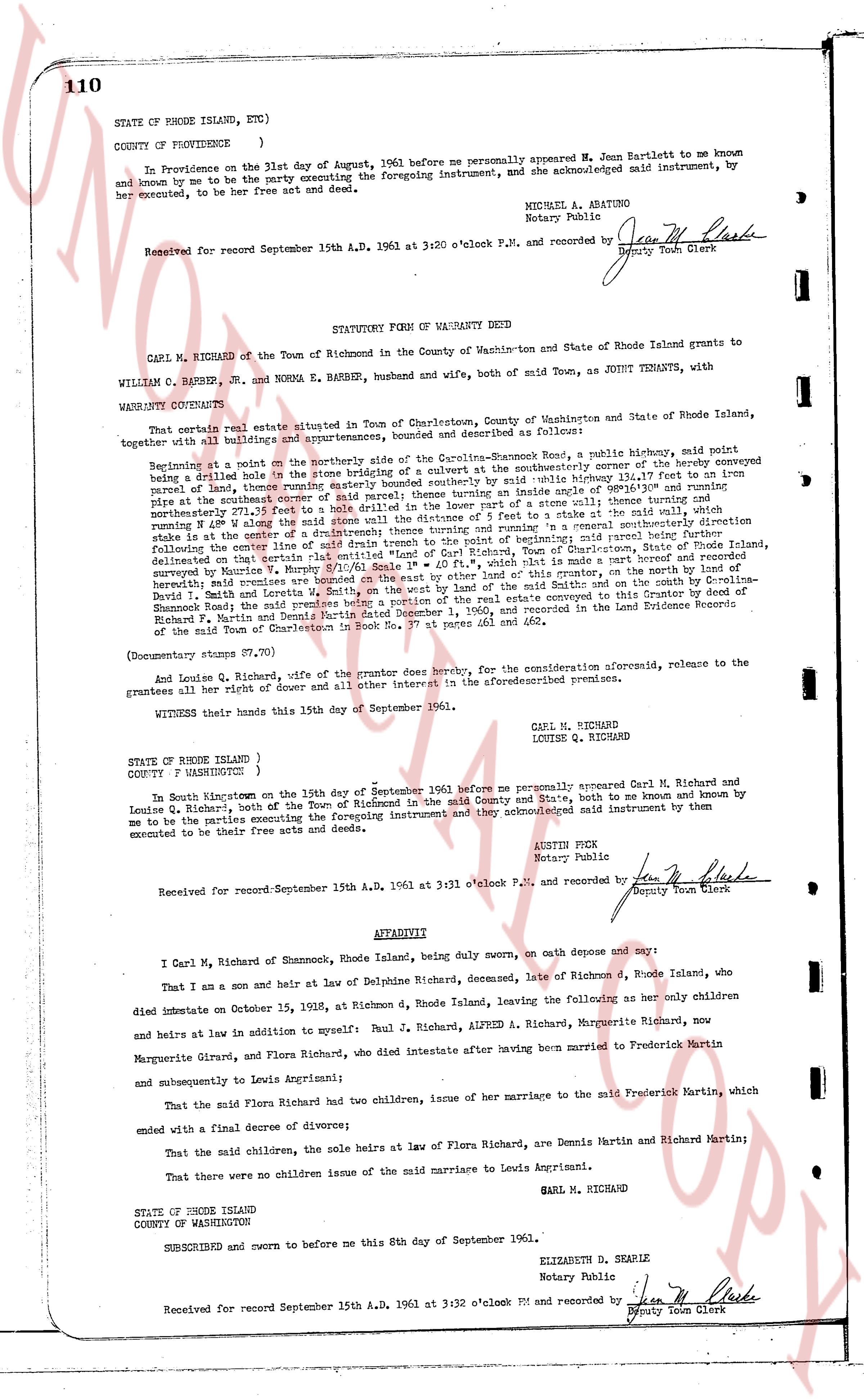
110
STATE OF RHODE ISLAND, ETC.)
COUNTY OF PROVIDENCE )
In Providence on the 31st day of August, 1961 before me personally appeared M. Jean Bartlett to me known and known by me to be the party executing the foregoing instrument, and she acknowledged said instrument, by her executed, to be her free act and deed.
MICHAEL A. ABATUNO
Notary Public
Received for record September 15th A.D. 1961 at 3:20 o'clock P.M. and recorded by Jean M. Clark
Deputy Town Clerk
----
STATUTORY FORM OF WARRANTY DEED
CARL M. RICHARD of the Town of Richmond in the County of Washington and State of Rhode Island grants to
WILLIAM C. BARBER, JR. and NORMA E. BARBER, husband and wife, both of said town, AS JOINT TENANTS, with
WARRANTY COVENANTS:
That certain real estate situated in Town of Charlestown, County of Washington and State of Rhode Island, together with all buildings and appurtenances, bounded and described as follows:
Beginning at a point on the northerly side of the Quidnick-Shannon Road, a public highway, said point being a drilled hole in the stone bridging of a culvert by said highway, easterly corner of the hereby conveyed parcel, then a line thence running south 27° 15' west 115.4' to a point by said public highway boundary 12.47' east to run along said highway south 27° 15' west 115.4' to a point by said highway boundary 12.47' east to run along said highway south 27° 15' west 115.4' to a point by said highway boundary 12.47' east to run along said highway south 27° 15' west 115.4' to a point by said highway boundary 12.47' east to run along said highway south 27° 15' west 115.4' to a point by said highway boundary 12.47' east to run along said highway south 27° 15' west 115.4' to a point by said highway boundary 12.47' east to run along said highway south 27° 15' west 115.4' to a point by said highway boundary 12.47' east to run along said highway south 27° 15' west 115.4' to a point by said highway boundary 12.47' east to run along said highway south 27° 15' west 115.4' to a point by said highway boundary 12.47' east to run along said highway south 27° 15' west 115.4' to a point by said highway boundary 12.47' east to run along said highway south 27° 15' west 115.4' to a point by said highway boundary 12.47' east to run along said highway south 27° 15' west 115.4' to a point by said highway boundary 12.47' east to run along said highway south 27° 15' west 115.4' to a point by said highway boundary 12.47' east to run along said highway south 27° 15' west 115.4' to a point by said highway boundary 12.47' east to run along said highway south 27° 15' west 115.4' to a point by said highway boundary 12.47' east to run along said highway south 27° 15' west 115.4' to a point by said highway boundary 12.47' east to run along said highway south 27° 15' west 115.4' to a point by said highway boundary 12.47' east to run along said highway south 27° 15' west 115.4' to a point by said highway boundary 12.47' east to run along said highway south 27° 15' west 115.4' to a point by said highway boundary 12.47' east to run along said highway south 27° 15' west 115.4' to a point by said highway boundary 12.47' east to run along said highway south 27° 15' west 115.4' to a point by said highway boundary 12.47' east to run along said highway south 27° 15' west 115.4' to a point by said highway boundary 12.47' east to run along said highway south 27° 15' west 115.4' to a point by said highway boundary 12.47' east to run along said highway south 27° 15' west 115.4' to a point by said highway boundary 12.47' east to run along said highway south 27° 15' west 115.4' to a point by said highway boundary 12.47' east to run along said highway south 27° 15' west 115.4' to a point by said highway boundary 12.47' east to run along said highway south 27° 15' west 115.4' to a point by said highway boundary 12.47' east to run along said highway south 27° 15' west 115.4' to a point by said highway boundary 12.47' east to run along said highway south 27° 15' west 115.4' to a point by said highway boundary 12.47' east to run along said highway south 27° 15' west 115.4' to a point by said highway boundary 12.47' east to run along said highway south 27° 15' west 115.4' to a point by said highway boundary 12.47' east to run along said highway south 27° 15' west 115.4' to a point by said highway boundary 12.47' east to run along said highway south 27° 15' west 115.4' to a point by said highway boundary 12.47' east to run along said highway south 27° 15' west 115.4' to a point by said highway boundary 12.47' east to run along said highway south 27° 15' west 115.4' to a point by said highway boundary 12.47' east to run along said highway south 27° 15' west 115.4' to a point by said highway boundary 12.47' east to run along said highway south 27° 15' west 115.4' to a point by said highway boundary 12.47' east to run along said highway south 27° 15' west 115.4' to a point by said highway boundary 12.47' east to run along said highway south 27° 15' west 115.4' to a point by said highway boundary 12.47' east to run along said highway south 27° 15' west 115.4' to a point by said highway boundary 12.47' east to run along said highway south 27° 15' west 115.4' to a point by said highway boundary 12.47' east to run along said highway south 27° 15' west 115.4' to a point by said highway boundary 12.47' east to run along said highway south 27° 15' west 115.4' to a point by said highway boundary 12.47' east to run along said highway south 27° 15' west 115.4' to a point by said highway boundary 12.47' east to run along said highway south 27° 15' west 115.4' to a point by said highway boundary 12.47' east to run along said highway south 27° 15' west 115.4' to a point by said highway boundary 12.47' east to run along said highway south 27° 15' west 115.4' to a point by said highway boundary 12.47' east to run along said highway south 27° 15' west 115.4' to a point by said highway boundary 12.47' east to run along said highway south 27° 15' west 115.4' to a point by said highway boundary 12.47' east to run along said highway south 27° 15' west 115.4' to a point by said highway boundary 12.47' east to run along said highway south 27° 15' west 115.4' to a point by said highway boundary 12.47' east to run along said highway south 27° 15' west 115.4' to a point by said highway boundary 12.47' east to run along said highway south 27° 15' west 115.4' to a point by said highway boundary 12.47' east to run along said highway south 27° 15' west 115.4' to a point by said highway boundary 12.47' east to run along said highway south 27° 15' west 115.4' to a point by said highway boundary 12.47' east to run along said highway south 27° 15' west 115.4' to a point by said highway boundary 12.47' east to run along said highway south 27° 15' west 115.4' to a point by said highway boundary 12.47' east to run along said highway south 27° 15' west 115.4' to a point by said highway boundary 12.47' east to run along said highway south 27° 15' west 115.4' to a point by said highway boundary 12.47' east to run along said highway south 27° 15' west 115.4' to a point by said highway boundary 12.47' east to run along said highway south 27° 15' west 115.4' to a point by said highway boundary 12.47' east to run along said highway south 27° 15' west 115.4' to a point by said highway boundary 12.47' east to run along said highway south 27° 15' west 115.4' to a point by said highway boundary 12.47' east to run along said highway south 27° 15' west 115.4' to a point by said highway boundary 12.47' east to run along said highway south 27° 15' west 115.4' to a point by said highway boundary 12.47' east to run along said highway south 27° 15' west 115.4' to a point by said highway boundary 12.47' east to run along said highway south 27° 15' west 115.4' to a point by said highway boundary 12.47' east to run along said highway south 27° 15' west 115.4' to a point by said highway boundary 12.47' east to run along said highway south 27° 15' west 115.4' to a point by said highway boundary 12.47' east to run along said highway south 27° 15' west 115.4' to a point by said highway boundary 12.47' east to run along said highway south 27° 15' west 115.4' to a point by said highway boundary 12.47' east to run along said highway south 27° 15' west 115.4' to a point by said highway boundary 12.47' east to run along said highway south 27° 15' west 115.4' to a point by said highway boundary 12.47' east to run along said highway
The page as recorded