The instrument's own words
page 1 · read by Gemma vision
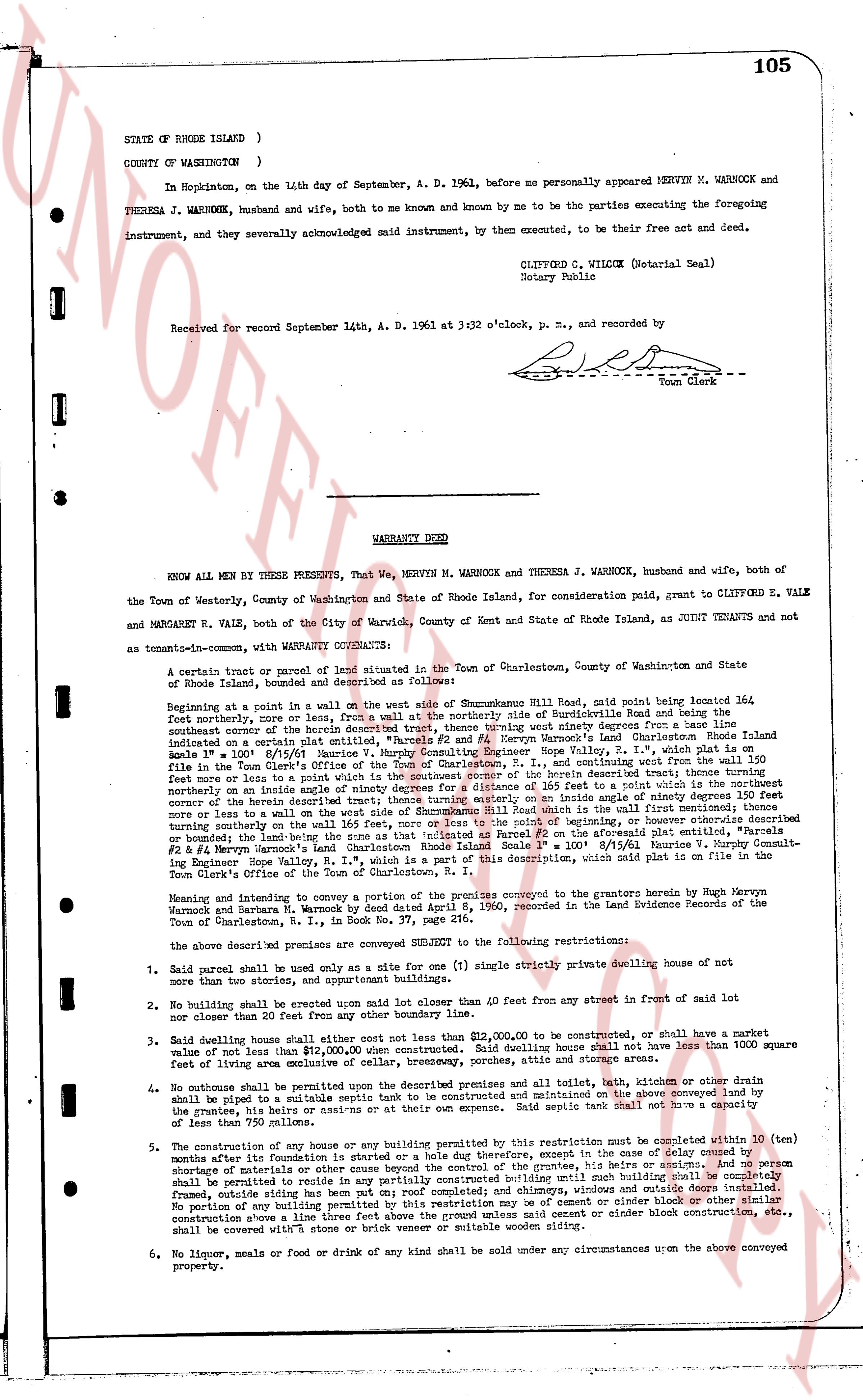
105
STATE OF RHODE ISLAND )
COUNTY OF WASHINGTON )
In Hopkinton, on the 14th day of September, A. D. 1961, before me personally appeared MERVYN M. WARNOCK and THERESA J. WARNOCK, husband and wife, both to me known and by me known to be the parties executing the foregoing instrument, and they severally acknowledged said instrument, by them executed, to be their free act and deed.
CLIFFORD C. WILCOX (Notarial Seal)
Notary Public
Received for record September 14th, A. D. 1961 at 3:32 o'clock, p. m., and recorded by [?] Town Clerk
WARRANTY DEED
KNOW ALL MEN BY THESE PRESENTS, That We, MERVYN M. WARNOCK and THERESA J. WARNOCK, husband and wife, both of the Town of Westerly, County of Washington and State of Rhode Island, for consideration paid, grant to CLIFFORD E. VALE and MARGARET R. VALE, both of the City of Warwick, County of Kent and State of Rhode Island, as JOINT TENANTS and not as tenants-in-common with WARRANTY COVENANTS:
A certain tract or parcel of land situated in the Town of Charlestown, County of Washington and State of Rhode Island, bounded and described as follows:
Beginning at a point in a wall on the west side of street of Shannockune Hill Road, said road being located 364 feet northerly, more or less, from a wall on the northerly side of Southwickville Road and being the southeast corner of the herein described tract of land, thence running west ninety degrees from a base line indicated on a certain plat entitled, "Parcels #1 and #2, Mervyn Warnock's Land Charlestown Rhode Island Scale 1" = 100' 8/15/61" drawn by [?] [?] surveyor, Pawtucket, R. I., a record copy of which is on file in the Town Clerk's Office of the Town of Charlestown, R. I., and continuing west from the wall 150 feet more or less to a point in a wall, thence running northerly ninety degrees from said base line, and continuing northerly on the inside of a nearby stone wall ninety degrees for a distance of 165 feet to a point which is the northeast corner of the herein described tract of land, thence running westerly ninety degrees from said base line, and continuing west more or less to a wall on the west side of street of Shannockune Hill Road which is the wall (first mentioned) thence running southerly on the inside of said wall along the zone as that is indicated as Parcel #2 on the aforesaid plat entitled, "Parcels #1 & #2, Mervyn Warnock's Land Charlestown Rhode Island Scale 1" = 100' 8/15/61" to the point of beginning. This description, which said plat is on file in the Town Clerk's Office of the Town of Charlestown, R. I.
Meaning and intending to convey a portion of the premises conveyed to the grantors herein by Hugh Mervyn Warnock and Theresa J. Warnock by a deed dated August 15, 1960, recorded in the Land Evidence Books of the Town of Charlestown, R. I., in Book No. 37, page 126.
The above described premises are conveyed subject to the following restrictions:
1. Said parcel shall be used only as a site for one (1) single strictly private dwelling house of not more than two stories, and appropriate buildings.
2. No dwelling shall be erected upon said lot closer than 40 feet from any street in front of said lot nor within 25 feet from any other boundary line.
3. Said dwelling house shall either cost not less than $20,000.00 to be constructed, or shall have a market value of not less than $12,000.00 when constructed. Said dwelling house shall not have less than 1000 square feet of living area not including basements, porches, garages and storage areas.
4. No outhouse shall be permitted on the premises under the premises and all toilet, bath, kitchen or other drain shall be piped to a suitable septic tank to be constructed and maintained on the above conveyed land by the proprietor his heirs or assigns or any person or persons for the time being the owner or owners thereof of less than 750 lumen square.
5. The construction of any dwelling house or building permitted by this restriction may be completed within 10 (ten) months after its foundation is started or a hole dug therefore, except in the case of delay caused by shortage of materials or other cause beyond the control of the grantee, his heirs or assigns. And no person shall be permitted to reside in any such house or building until said house or building is completely framed, outside walls dry and tight, on roof completed; chimneys, windows and outside doors installed. No portion of any building permitted by this restriction may be of cement or cinder block construction, etc., construction above a living space of one story. Any such cement or cinder block construction, etc., shall be covered with a stone or brick veneer or suitable wooden siding.
6. No liquor, meals or food or drink of any kind shall be sold under any circumstances upon the above conveyed property.
page 2 · read by Gemma vision
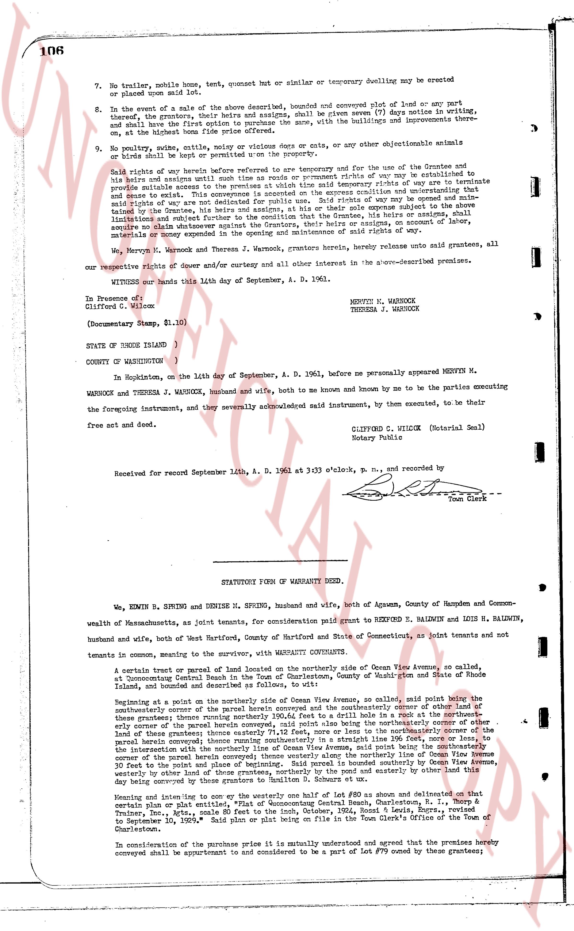
106
7. No trailer, mobile home, tent, quonset hut or similar or temporary dwelling may be erected or placed upon said land.
8. In the event of a sale of the above described, bounded and conveyed subject of land or any part thereof, the grantors, their heirs and assigns, shall be given seven (7) days notice in writing, and shall have the first option to purchase the same, with the buildings and improvements there-on at the lowest bona fide offer received.
9. No poultry, swine, cattle, noisy or vicious dogs or cats, or any other objectionable animals or birds shall be kept or permitted upon the property.
Said rights of way herein before referred to are temporary and for the use of the Grantees and to his heirs and assigns until such time as the town or county prompt rights of way are established to provide suitable access to the premises at which time said temporary rights of way are to terminate and cease to exist. This conveyance provides no easement for public use. Said rights of way may be opened and maintained by the Grantees, his heirs and assigns, at their sole expense subject always to the following limitations and conditions: that the Grantees, his heirs or assigns, shall assume and acquire no claim whatsoever against the Grantors, their heirs or assigns, in account of labor, materials or damage occurring in the opening or maintenance of said rights of way.
We, Mervyn M. Warnock and Theresa J. Warnock, grantors herein, hereby release unto said grantees, all our respective rights of dower and curtesy and all other interest in the above-described premises.
WITNESS our hands this 14th day of September, A. D. 1961.
In Presence of:
Clifford E. Vale
(Documentary Stamp, $1.10)
MERVYN M. WARNOCK
THERESA J. WARNOCK
STATE OF RHODE ISLAND )
)
COUNTY OF WASHINGTON )
In Hopkinton, on the 14th day of September, A. D. 1961, before me personally appeared MERVYN M. WARNOCK and THERESA J. WARNOCK, husband and wife, both to me known and by me to be the parties executing the foregoing instrument, and by themselves acknowledged said instrument, by them executed, to be their free act and deed.
CLIFFORD E. VALE (Notarial Seal)
Notary Public
Received for record September 14th, A. D. 1961 at 3:33 o'clock, p. m., and recorded by
[Signature]
Town Clerk
----
STATUTORY FORM OF WARRANTY DEED.
We, EDWIN R. SPRING and DENISE M. SPRING, husband and wife, both of Agawam, County of Hampden and Commonwealth of Massachusetts, as joint tenants, for consideration paid grant to REYMOND E. BALMWIN and LOIS H. BALMWIN, husband and wife, both of West Hartford, County of Hartford and State of Connecticut, as joint tenants and not tenants in common, meaning to the survivor, with WARRANTY CONVEYANTS.
A certain tract or parcel of land located on the northerly side of Ocean View Avenue, so called, at Dunstable Central State Hospital, in the town of Hopkinton, County of Washington, State of Rhode Island, and bounded and described as follows to wit:
Beginning at a point on the northerly side of Ocean View Avenue, so called, said point being the southeasterly corner of the parcel of land conveyed to the Grantors and the northeasterly corner of other land of these grantees; thence running northerly 100.64 feet to a drill hole in a rock at the northeasterly corner of said parcel; thence running easterly 100 feet to a drill hole in a rock at the northeasterly line of these grantees; thence easterly 71.2 feet, more or less now to the northeasterly corner of the parcel herein conveyed; thence running southerly 100.64 feet to the line of Ocean View Avenue, so called, the intersection with the northerly line of Ocean View Avenue, said point being the southeasterly corner of the parcel herein conveyed; thence westerly along Ocean View Avenue to the southwesterly corner of the parcel herein conveyed; thence northerly along the boundary line of Ocean View Avenue 100 feet to the point of beginning. The parcel of land herein conveyed is bounded southerly by Ocean View Avenue, westerly by other land of these grantees, northerly by the mound and easterly by other land this day being conveyed to the Grantees.
Meaning and intending to convey one to the westerly half of Lot #80 as shown and delineated on that certain plan or plat entitled, "Map Accompanying Central Bank, Rhode Island, M. T. Sharp & Treasury Co., Inc., dated September 10, 1929," filed Sept 14, 1930, in Town's records, dated to September 10, 1929. Said plan or plat being on file in the Town Clerk's Office of the Town of Charlestown.
In consideration of the purchase price it is mutually understood and agreed that the premises hereby conveyed shall be appurtenant to and considered to be a part of Lot #79 owned by these grantees;
The page as recorded